Sección y punto del estratotipo del límite global
Una sección y punto de estratotipo de límite global (GSSP) es un punto de referencia acordado internacionalmente en una sección estratigráfica que define el límite inferior de una etapa en el tiempo geológico escala. El esfuerzo por definir los GSSP está a cargo de la Comisión Internacional de Estratigrafía, parte de la Unión Internacional de Ciencias Geológicas. La mayoría, pero no todos, los GSSP se basan en cambios paleontológicos. Por lo tanto, los GSSP generalmente se describen en términos de transiciones entre diferentes etapas de fauna, aunque se han descrito muchas más etapas de fauna que GSSP. El esfuerzo de definición de GSSP comenzó en 1977. A partir de 2022, 77 de las 101 etapas que necesitan un GSSP tienen un GSSP ratificado.
Reglas
Una sección geológica tiene que cumplir con un conjunto de criterios para ser adaptada como GSSP por el ICS. La siguiente lista resume los criterios:
- Un SGP tiene que definir el límite inferior de una etapa geológica.
- El límite inferior tiene que definirse usando un marcador primario (generalmente dato de primera aparición de una especie fósil).
- También debe haber marcadores secundarios (otros fósiles, química, inversión geomagnética).
- El horizonte en el que aparece el marcador debe tener minerales que pueden datarse radiométricamente.
- El marcador tiene que tener correlación regional y global en afloramientos de la misma edad
- El marcador debe ser independiente de las facultades.
- El afloramiento tiene que tener un espesor adecuado
- La sedimentación debe ser continua sin cambios en las facultades
- El afloramiento no debe ser afectado por movimientos tectónicos y sedimentarios, y metamorfismo
- El afloramiento tiene que ser accesible a la investigación y libre de acceso.
- Esto incluye que el afloramiento tiene que estar ubicado donde se puede visitar rápidamente (Aeropuerto Internacional y buenas carreteras), tiene que mantenerse en buenas condiciones (Idealmente una reserva nacional), en terreno accesible, lo suficientemente extenso como para permitir el muestreo repetido y abierto a investigadores de todas las nacionalidades.
Sección y puntos de estratotipo de límite global acordados
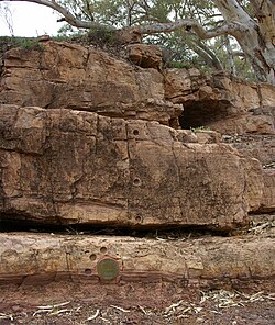
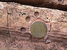
Una vez que se ha acordado un límite de GSSP, un "punta dorada" se introduce en la sección geológica para marcar el límite preciso para los futuros geólogos (aunque en la práctica, la 'punta' no necesita ser dorada ni una punta real). El primer límite estratigráfico se definió en 1972 al identificar el límite silúrico-devónico con una placa de bronce en una localidad llamada Klonk, al noreste del pueblo de Suchomasty en la República Checa. Los GSSP también se denominan a veces Golden Spikes.
Fortune Head GSSP
El GSSP del límite Precámbrico-Cámbrico en Fortune Head, Newfoundland es un GSSP típico. Es accesible por camino pavimentado y está reservado como reserva natural. Se dispone de una sección continua desde lechos claramente precámbricos hasta lechos claramente cámbricos. El límite se establece en la primera aparición de un rastro fósil complejo Treptichnus pedum que se encuentra en todo el mundo. Es poco probable que el GSSP de Fortune Head sea arrastrado por el agua o reconstruido. No obstante, Treptichnus pedum no es ideal como fósil marcador, ya que no se encuentra en todas las secuencias del Cámbrico, y no se garantiza que se encuentre al mismo nivel en todas las exposiciones. De hecho, erosionando aún más su valor como marcador de límites, desde entonces ha sido identificado en estratos 4m por debajo del GSSP. Sin embargo, no se conoce ningún otro fósil que sea preferible. No hay lecho datable radiométricamente en el límite de Fortune Head, pero hay uno ligeramente por encima del límite en lechos similares cercanos. Estos factores han llevado a algunos geólogos a sugerir que este GSSP necesita una reasignación.
Edades estratigráficas estándar globales
Debido a que definir un GSSP depende de encontrar secciones geológicas bien conservadas e identificar eventos clave, esta tarea se vuelve más difícil a medida que uno retrocede en el tiempo. Antes de hace 630 millones de años, los límites en la escala de tiempo geológico se definían simplemente por referencia a fechas fijas, conocidas como "Edades estratigráficas estándar globales".
Contenido relacionado
Esperanza diamante
Cúpula geodésica
Cabo Guardafui


