
Würm Glaciation (Ice Age)
| Glacier/Engineering | Start, in years |
| Holocene | 9700 a. C. |
| Würm Glacier | 110 000 |
| Interglaciar Riss-Würm | 140 000 |
| Glacier Riss | 200 000 |
| Interglaciar Mindel-Riss | 390 000 |
| Mindel Glacier | 580 000 |
| Interglaciar Günz-Mindel | 600 000 |
| Günz Glacier | 850 000 |

The Würm Glaciation, also called Ice Age, is the last glacial period that has occurred in the geological history of the Earth. It began about 110,000 years ago and ended around 9700 BC. C., giving way to the Holocene, the period of current temperate climate.
During this period, extensive areas of the Earth's surface were occupied by ice caps, the climate became extremely stormy globally, which even affected tropical areas and caused a marine regression that decreased the surface of oceans and seas. The main areas covered by ice were the Patagonian Andes, the entire Andes mountain range to the eastern Colombian mountain range, Fenoscandia, New Zealand, the Alps, the northern North American Cordillera, the area of the great lakes - including all of eastern Canada—Iceland, the British Isles, as well as Greenland and Antarctica that have retained their glaciers since then. As a result of this glaciation, some areas, now arid, had greater rainfall, as is the case of the Altiplano. From the point of view of human archeology, the ice age is located in the Paleolithic and early Mesolithic. When glaciation began, Homo sapiens was confined to lower latitudes and used tools comparable to those used by Neanderthals in western and central Eurasia and Denisovans and Homo erectus in Asia. Archaeological and genetic data suggest that the source populations of Paleolithic humans survived the Ice Age in sparsely forested areas and dispersed across areas of high primary productivity, avoiding dense forest cover.
Local names
The last ice age is called by different names depending on the place that was affected. Around the Alps it is called Würm; in northern Europe, Vistula or Weichsel; in eastern North America, Wisconsin; in the Venezuelan Andes, Mérida; in the south of Chile, Llanquihue; in New Zealand, Otago and Lauricocha in Peru.
Development
It is considered that the ice age began 110,000 years ago and ended 12,000 years ago. During this period the species Homo sapiens left Africa and dispersed, first throughout Asia and from there throughout the continents and islands.
According to one theory, the humans of that time took advantage of this glaciation to make their way from Asia to America through the Bering Strait. During this glacial period, the Earth's climate became very cold. Then the glaciers advanced beyond the polar caps, close to the tropics. In that area the continents were covered in ice, the lakes, lagoons and rivers were frozen. The shallow seas disappeared, because their waters became glaciers. It was precisely in those times when the continental and insular straits and archipelagos were left without liquid coverage; Therefore, and temporarily, many nearby areas were united. It joined, for example, Australia-Tasmania with New Guinea, the Philippines and Indonesia. The same thing happened between Japan and Korea. The continental territory of South America was joined with Tierra del Fuego.
Between Asia and America, as its water level decreased, the Bering Strait became the "Bering Bridge" or "Beringia Bridge." It is named in honor of the navigator Vitus Jonassen Bering (Denmark, 1681-1741), who explored those seas with the help of the Russian tsars.
Scientists claim that the "Beringian Bridge", suitable for being crossed by people and animals, lasted a short geological period. In its first stage, about 4,000 years and, in its second stage, about 15,000 years. That land bridge had a length of 1,500 km and a maximum width of 75 km. These magnitudes are more characteristic of an isthmus, but scientists maintain the name "bridge" because of its meaning of "union" between both continents.
For 19,000 years, primitive groups in Asia had the opportunity to cross the "Beringian Bridge." That time was enough for the first human groups and other species from Asia to reach northern America.
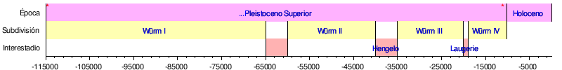
The Wurmian glaciations are periods of more intense cold in the Paleolithic, which are divided into:
- Würm I
- Würm II
- Würm III
Between these periods there are periods of oscillations that separate them and are called interglacials or substages of less cold climate.
Scandinavia and northern Europe

Alternative names include Weichsel glaciation or Vistulian glaciation (referring to the Polish river Vistula or its German name Weichsel). Evidence suggests that the ice sheets reached their maximum size for only a short period, between 25,000 and 13,000 BP. Eight interstadials have been recognized in the Weichselian, including Oerel, Glinde, Moershoofd, Hengelo and Denekamp; however, correlation with isotope stages is still in progress. During the glacial maximum in Scandinavia, only the western parts of Jutland were ice-free, and a large part of what is now the North Sea was land. dry land that connected Jutland with Great Britain (see Doggerland).
During the height of the Würm glaciation, between 24,000 and 10,000 years BC, most of western and central Europe and Eurasia was an open steppe-tundra, while the Alps featured fields of solid ice and mountain glaciers, Scandinavia and much of Britain were under ice. During the Würm, the Rhône glacier covered the entire western Swiss plateau, reaching the present-day regions of Solothurn and Aarau. In the Bern region it merged with the Aar glacier. The Rhine Glacier is currently the subject of the most detailed studies.
Local subdivisions
These subdivisions are those made for Germany, having a correspondence with the French ones as indicated:
| Germany | France |
|---|---|
| Würm I | Würm I + II |
| Würm II | Würm III |
| Würm III | Würm IV |
In the Iberian Peninsula they are grouped into two blocks: ancient Würm (I + II) and recent Würm (III + IV).
Both the Iberian Peninsula and what is currently France, for the most part, can be attributed the following chronology, taking into account the variations that exist according to regional characteristics:
- Source: Sanchidrián, J. L. (2001). Prehistoric art manual. Ariel. pp. 16-7. ISBN 9788434466173. Consultation on 30 August 2011.
Contenido relacionado
Annex: Municipalities of the province of Huesca
Length
Ichnanthus