Watershed
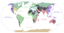
The watershed line, drainage divide or simply divide is the boundary between two contiguous river basins (two contiguous river basins). The rainwater that falls on each side of the divide ends up being collected by the main rivers of the respective basins or springs, and may end up in very distant destinations. For example, the continental divide of America is the imaginary line that separates the waters that end up draining the Pacific Ocean from those that drain into the Atlantic. Dividing lines have historically been used as criteria to mark territorial borders.
When two watersheds intersect, that is, where three hydrographic basins meet, a hydrographic vertex or tripont appears.
In mountainous regions
In mountainous regions or regions with pronounced relief, the divide passes through the ridges and elevations where the last slopes of each basin join. Conversely, the establishment of a dividing line in swampy regions can be almost impossible. Thus, the waters of the Belarusian wetlands, depending on the rainfall or the direction of the wind, can flow into the Black Sea or into the Baltic Sea. The same occurs with the Amazon and Paraná river basins, whose waters are mixed in their upper course.
In geopolitics
The watershed is an important geopolitical criterion by which borders have been established between countries, states, or subnational entities. The divide that marks the great slopes between different oceans or seas on a continent is called the continental divide.
In Roman law
In Roman law this criterion is called Divortium aquarium, which is a Latin expression meaning Dividing waters. Said of the imaginary line that traces the separation between two slopes or bordering river basins. In international law, watersheds are frequently used as a criterion to establish border sections in regions, such as the Amazon, with a high density of river channels and a scarcity of other geographical references or a lack of historical borders.
Contenido relacionado
Kingdom of Iberia
Maracay
Wadati-Benioff zone


