
Washington (state)
Washington, also called Washington State to differentiate it from Washington D.C., is one of fifty states that, along with the District of Columbia, make up the USA. Its capital is Olympia and its largest city, Seattle. It is located in the western region of the country, Pacific division, bordering Canada to the north, Idaho to the east, Oregon to the south, and the Pacific Ocean to the west. It was admitted to the Union on November 11, 1889, as the 42nd state.
It was named in honor of the leader of the American forces in the 1776 American War of Independence and the first president of the United States, George Washington. The names of many cities and counties in the United States honor various US presidents, but the state of Washington is the only state to be named after a US president. To avoid confusion with the federal capital, in the United States the state is usually called "Washington State" and "D. c.” (abbreviation of "District of Columbia", District of Columbia in English), "federal city" or "city of Washington" or to the national capital.
Washington is home to vast coniferous forests, which have earned it the nickname Evergreen State. These forests make Washington a leader in the American lumber industry. It is cut by several rivers and dotted with several lakes, which creates favorable terrain for the installation of dams. Here is located the largest in the country, the Grand Coulee Dam, on the Columbia River. Its economy, however, is mainly focused on tourism and the aerospace industry. The second largest aircraft manufacturer in the world, Boeing, has its headquarters in this state, as well as several of its factories.
The first Europeans to explore this region were the Castilians, and later, the British founded the first settlements. The region was originally part of a larger area called Oregon Country, a territory disputed between the Americans and the British between the 1810s and the 1840s. In 1846, the Oregon Treaty established that all land south of the 49th parallel of the Oregon Country would pass to the control of the United States (with the exception of Vancouver Island). Until 1859, Washington was part of the Oregon Territory, created from the US part of the Oregon Country. In 1859, the territory of Washington was created, which was named in honor of George Washington.
History
Until 1889
In the region where the state of Washington is located today, various Native American tribes lived several thousand years ago, long before the arrival of the first Europeans. Various indigenous tribes lived in the region, and most were part of two groups: the Salishians and the Penutians. The former lived in the north and on the Washington coast, while the latter lived in the interior, along the west and south of the state.
The first Europeans to explore Washington were the Castilians, in the 1750s. They intensively explored the coastline of the current state, and claimed the area for the, then, dynastic union between Castile and Aragon, in accordance with the Treaty of Tordesillas. However, they did not found any permanent settlement. Such explorations were carried out under fear of a Russian expansion—which then controlled Alaska—in a southerly direction. The Englishman George Vancouver is usually considered the first European to map the coastline of present-day Washington state, during the year 1792. However, that same year a map of the Northwest American coast had been published that included the entire area, due to Juan Francisco de la Bodega y Quadra, who had traveled it in 1775. Both sailors exchanged cartographic information and maintained a friendly relationship during the resolution of the incident on the island of Nutca. The expedition led by Alejandro Malaspina had also explored the area. The English, at least in principle, were not interested in founding permanent settlements either, even though they did claim the region to the British crown.
In 1791 under Spanish control by Manuel Quimper, in Nea Bay (practically at the extreme northwest of the current state of Washington and on the southern shore of the strategic Strait of Juan de Fuca), the first European settlement was established by the Spanish Empire and this due to the expedition of the sailor Salvador Fidalgo, it was a fortified position: the Fort of Núñez Gaona (also called Fort of Santa Rosalía ) becoming the first European settlement in territories corresponding to the current state of Washington and then corresponding to the litigated territory of Oregon.

A year later, the American Robert Gray, along with his expedition, made up of hunters and traders, were the first Americans to explore the interior of Washington, having set out from Boston, Massachusetts, under the command of a private company. They landed on the Washington coast in 1792. The United States then went on to claim the region. British and American traders and hunters hunted and traded in the region of present-day Washington. The Hudson's Bay Company founded the first permanent settlement in the region, the present-day city of Vancouver.
American expansion westward resulted in increasing numbers of American settlers moving to the region beginning in the 1840s. The United States came to claim all land south of the 54th meridian. 40' and west of the Rocky Mountains. The British had demanded that the border be the 49th meridian, and it would continue south along the Columbia River west of the Rocky Mountains—in which case much of western Washington state would come under control. British. In 1846, the United States and the United Kingdom reached an agreement, which delimited the border between the United States and the British colonies in the region along the 49th parallel.
In 1848, under pressure from settlers living in the northwestern United States, the US government established the Oregon Territory, and implemented a government in the region. This territory included all the current states of Oregon, Idaho and Washington. During the 1850s, Seattle is founded. In 1859, Oregon is elevated to the category of state and the Territory of Oregon becomes the Territory of Washington. Subsequently, the government of the Territory of Washington would begin to pressure the indigenous natives to settle on reservations, and thus, provide land to white settlers. Following US President Franklin Pierce's attempted purchase of Indian lands, of particular importance is the response from Chief Seattle of the Duwamish tribe (letter known as "We are part of the land" (translation of the version of Joseph Campbell into Spanish), where the chief of the tribe presents a particular vision of the world and a way of understanding nature. The Salishians accepted, but not the Penutians, who went to war with white settlers in the region in 1855. The war between the American settlers and the Indians lasted until 1858, when the Penutians were defeated and forced to move to Indian reservations.
From the beginning of the 1860s, the number of settlers who began to settle in the Washington Territory grew, thanks to the discovery of large gold mines in the region. Population growth in the territory led to the secession of several areas west of Washington, for the formation of the Idaho Territory. Washington's territorial limits, since then, have not changed. Washington's strong population growth would continue in the 1870s and 1880s. Seattle became a major port center. In 1883, the Northern Pacific Railway was inaugurated, connecting Washington with the eastern part of the country. On November 11, 1889, the territory was elevated to state status, becoming the forty-second state of the United States of America.
1889 - present day
Washington's economy, in its first decades as a state, depended primarily on agriculture and mining. Throughout the 1890s, modern irrigation techniques would allow agriculture to be practiced in the desert eastern Washington region. There, cattle were replaced by wheat crops. Other important sources of income were the timber industry and fishing. At the turn of the 20th century, Washington's reputation at home was as dangerous and wild as the rest of the world. American West, only with lumberjacks instead of cowboys and forests instead of deserts. In particular, the city of Aberdeen had a reputation as the toughest city west of the Mississippi, due to gambling, violence, widespread drug use, and prostitution.


Seattle prospered with American migration to Hawaii and Alaska, and was a major supply center for Hawaii for several decades, and is still Alaska's primary supply center today. Washington's economy boomed with the start of World War I. Wood and food production increased significantly. Seattle also became an industrialized city, one of the largest manufacturers of ships and aircraft in general throughout the war. In 1917, Boeing was founded in Seattle. The war generated a greater union between the workers of the state, and several unions were created. After the end of the war, in February 1919, the city's unions organized a general strike in Seattle, which drew more than 60,000 workers.
The Great Depression, which began in 1929, ruined the state's economy. To try to minimize the problems caused by the Depression, such as misery, unemployment and poverty, the state began the construction of various public works, including several dams, which culminated in the inauguration of the Grand Coulee Dam in 1941., to this day the largest operating dam in the United States.
Washington's economy recovered with the onset of World War II. The Seattle metropolitan area, thanks to its proximity to the Pacific battlefront, became one of the largest manufacturers of military ships, and the largest manufacturer of military aircraft in the country. In 1943, the US government opened a nuclear power plant in the state, the Hanford Site. This plant generated much of the nuclear fuel (plutonium) used in the atomic bombs of Hiroshima and Nagasaki. Washington industrialized rapidly, during and after the end of World War II, and the agriculture, mining, and lumber industries lost much of their importance in the state's economy.

During the 1960s, the Washington government approved a series of programs to clean up rivers and lakes polluted by industrial and fecal waste. Boeing's ascension as the world's largest aircraft manufacturer led to a large population growth in the Seattle metropolitan area. In 1962, Seattle held the 1962 World's Fair. The biggest attraction of the fair was the construction of the Space Needle, a 184-meter-tall tower, inaugurated a year earlier, in 1961. Later, In 1964, the Canadian and US governments began a joint program to build various dams along the Columbia River and its tributaries.
On May 18, 1980, Mount Saint Helens erupted. Dormant for hundreds of centuries, the volcano literally exploded, causing total destruction in a radius of about 25 kilometers. In total, 57 people died, and the damage caused amounted to more than 4,000 million dollars. Washington's economy entered a recession that lasted for nearly two years. The eruption released volcanic ash within a radius of more than 1,500 kilometers from the explosion, mainly in the first 200 kilometers, covering several cities in a thick layer of ash, several centimeters thick.
During operation, the Hanford Site released several tons of slightly radioactive water (used as a cooler) per day into the Columbia River. On top of that, failures throughout its construction caused the surrounding soil to become contaminated. The reactor was shut down in 1971, and in 1989, the Washington government, along with the US government, began a major cleanup program, scheduled to be completed by 2030.
In 1996, Gary Locke is elected governor of the state. Locke was the first American of Chinese descent to be elected governor of a US state.
Geography
Washington is located in the northwestern part of the 48 contiguous United States of America. It limits to the west with the Pacific Ocean, to the north with the Canadian province of British Columbia, to the east with Idaho and to the south with Oregon. The Columbia River forms most of the border between Washington and Oregon. Washington is a state of contrasts. For example, much of the state is covered by forests (the forested region of the Olympic Peninsula is among the rainiest in the world), while, on the other hand, much of the eastern part of the state is arid, and it is very rare to encounter trees. The altitude variation is enormous, between zero meters, along the coast, to more than four thousand meters.
The state's coastline with the Pacific Ocean is about 255 kilometers long. If we count all the regions bathed by the sea—bays, estuaries, and oceanic islands—this total rises to 4,870 kilometers. The main river of the state is the Columbia River, whose source is located in British Columbia. This river runs through Washington from north to south for about 1,100 kilometers, turning west at the Oregon border. The dams installed along the river produce half of all the electricity generated in the country's hydroelectric plants. Grand Coulee Dam is currently the third largest dam in the world and the largest in the country.
Several other rivers cross the state. Most originate in the Rocky Mountains and flow towards the Pacific Ocean or the Columbia River. Most of the state forests—which cover almost half of the state—are located in its western part.
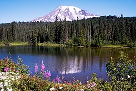
Mount Rainier reflected in Lake Reflection.

Lake Quinault.

Columbia River Gorges.

Lake Wenatchee.


.jpg)

Maps

Washington State Map

The Columbia River crosses Washington from the northeast to the southwest, forming much of its southern border with Oregon

The Snake River also flows through Washington, in its last stretch, until it breaks down in Columbia
![Regiones fisiográficas de Washington.[4]](https://upload.wikimedia.org/wikipedia/commons/thumb/9/96/Physiographic_regions_Washington.svg/120px-Physiographic_regions_Washington.svg.png)
physiographic regions of Washington.


![Regiones fisiográficas de Washington.[4]](https://en.wikipedia.org/wiki/Archivo:Physiographic_regions_Washington.svg)
Physiographic Regions
We can divide Washington into six physiographic regions:

- The Okanogan Highlands (which is part of the Rocky Mountains) occupy the northeast of the state of Washington. They are characterized by their high altitude and their very rough terrain. There are several gold mines, zinc, granite and magnesium.
- La Columbia Basin It occupies much of the central region of Washington, as well as the entire central-east and south-east region. It is characterized by its average altitude, which varies between 150 and 600 meters, which contrasts with the neighboring regions, of higher altitude, and by its relatively uneven terrain. It is located immediately south of the Okanogan Highlands. There are deserts instead of forests, due to the mountains that sometimes stop the clouds of the west.
- The Cascade Mountains extend from British Columbia to Northern California and Nevada. They extend immediately to the west of the Rocky Mountains and the Columbia Basin. It is a region with several active volcanoes, including Mount St. Helens, who killed 57 people and caused billions of dollars in damages after a gigantic eruption on May 18, 1980. It has a highly rugged terrain, and several peaks with more than three thousand meters of altitude. The highest point in the state, Mount Rainier, is 4,400 metres high.
- The Plains of Puget extend west of the Cascade Mountains. They are characterized by their uneven terrain, by their very fertile soil and by the presence of large forest masses—about 70% of the state forests are located in this region. It's the most populous region in the state.
- The Olympic Mountains are located northwest of the state, west and north of the Plains of Puget. They are characterized by their rough terrain, and by the presence of mountains with a thousand meters of altitude or more. It's a sparsely populated region.
- The Colinas Willapa extend from the southern coast of the state to the central region of the Oregon coast. Most of this region is covered by forests. It is characterized by its rough terrain, and by its low altitude mountain chains.
Climate
Due to the proximity of large bodies of water and warm ocean currents from the Pacific Ocean, western Washington State has the mildest climate of any state in the northern 48 United States. Washington's climate is temperate, with four distinct seasons. Summers are cool and less hot than other northern states, while winters are relatively mild, less cold than any other northern state. Much of western Washington experiences very high rates of average annual precipitation. For its part, the eastern part of the state experiences very hot summers and cold winters, and low annual precipitation rates.

In winter, the average temperature is 5 °C in the west and -3 °C in the east of the state. The lowest averages are in the higher-altitude regions of Washington, at -8°C in regions above 5,000 feet. The minimum temperatures vary between -30 °C to 12 °C, and the maximum between -22 °C and 18 °C. The lowest temperature recorded in the state, -44 °C, was measured on December 30, 1968, in Mazama and Winthrop, in the north of the state.
In summer, the average temperature is 16 °C in the west and 23 °C in the east of the state. The lowest averages are recorded along the Washington coastline. The minimum temperatures vary between 5 °C and 18 °C, and the maximum temperatures between 14 °C and 35 °C. The highest temperature recorded in the state, 48 °C, was measured on August 5, 1961, at Ice Harbor Dam, in the southeast of the state.
Mean annual rainfall rates of rainfall vary from 100 to 350 centimeters per year in the west of the state to only 10 to 35 centimeters in the central-eastern region. Average annual snow precipitation rates vary between 15 centimeters on the coast, 130 to 200 centimeters in mountainous regions, and 30 centimeters in the central-eastern region.
| Seattle | |||||||||||||
|---|---|---|---|---|---|---|---|---|---|---|---|---|---|
| Month | Ene | Feb | Mar | Abr | May | Jun | Jul | Ago | Sep | Oct | Nov | Dic | Year |
| Average maximum temperature (°C) | 8 | 10 | 12 | 15 | 19 | 22 | 25 | 24 | 21 | 17 | 12 | 9 | 16 |
| Average minimum temperature (°C) | 3 | 3 | 5 | 7 | 10 | 12 | 13 | 14 | 12 | 9 | 5 | 4 | 8 |
| Precipitation (mm) | 98.0 | 54.6 | 106.5 | 88.6 | 50.0 | 36.1 | 26.4 | 19.3 | 34.3 | 54.7 | 175.51 | 120.9 | 868.42 |
Demographics

| Historical population | ||
|---|---|---|
| Year | Pob. | ±% |
| 1850 | 1201 | - |
| 1860 | 11 594 | +865.4% |
| 1870 | 23 955 | +106.6% |
| 1880 | 75 116 | +213.6% |
| 1890 | 357 232 | +375.6% |
| 1900 | 518 103 | +45.0% |
| 1910 | 1 141 990 | +120.4% |
| 1920 | 1 356 621 | +18.8% |
| 1930 | 1 563 396 | +15.2% |
| 1940 | 1 736 191 | +11.1% |
| 1950 | 2 378 963 | +37.0% |
| 1960 | 2 853 214 | +19.9% |
| 1970 | 3 409 169 | +19.5% |
| 1980 | 4 132 156 | +21.2% |
| 1990 | 4 866 692 | +17.8% |
| 2000 | 5 894 121 | +21.1% |
| 2010 | 6 724 540 | +14.1% |
| 2020 | 7 705 281 | +14.6% |
According to the 2005 census, Washington had an estimated population of 6,271,973 inhabitants, which represents an increase of 80,713 inhabitants (or what is the same, 1.3%), in relation to the previous year and an increase of 393,619 inhabitants (or 6.7%), in relation to the year 2000. The demographic increase since the last census is due to a natural growth of 180,160 people (418,055 births minus 237,895 deaths) and an increase in migration net of 215,216 people in the state. External migrations have given rise to a net increase of 134,242 people, while internal migrations produced a net loss of 80,974 people.
In 2004, 10.3% of the state's inhabitants (631,500 people) were not born in the United States, of whom an estimated one hundred thousand (1.6%) are illegal immigrants.
About 83% of Washington's population lives in metropolitan areas. The largest of these is the Seattle metropolitan area, which is the state's largest city with 375,000 residents. Its metropolitan area has about 3.1 million inhabitants, or what is the same, about two fifths of the state's population. Most of the population is concentrated in the northwest of the state.
Population
| racial composition | 1990 | 2000 | 2010 |
|---|---|---|---|
| Whites | 88.5% | 81.8% | 77.3% |
| African American | 3.1% | 3.2% | 3.6% |
| Native American | 1.7% | 1.6% | 1.5% |
| Asian | 4.3% | 5.5% | 7.2% |
| Pacific Island | - | 0.4% | 0.6% |
| Other | 2.4% | 3.9% | 5.2% |
| Two or more Races | - | 3.6% | 4.7% |
According to the 2016 American Community Survey, 12.1% of Washington's population was of Hispanic or Latino origin (of any race): Mexican (9.7%), Puerto Rican (0.4%), Cuban (0.1%) and other Hispanic or Latino origin (1.8%). The five largest ancestry groups were: German (17.8%), Irish (10.8%), English (10.4%), Norwegian (5.4%), and American (4.6%).
Mexicans are mainly concentrated in the southeast and center-south region, where they work in the fields as cheap labor (many of these rural workers are illegal). Wahkiakum County, like most counties in the state, is home to many people of Scandinavian origin.
Washington's population of Asian descent is the fifth largest in the country. Within it, the largest ethnic group is the Filipinos. Gary Locke was elected the first Asian-American governor in 1997.
African Americans outnumber Asians and Hispanics in many communities. In Seattle, they are moving to the southern part of the city and various suburban areas, such as southern King County.
Numerous Indian reservations are located in Washington. Many cities have unusual names given by Native Americans, such as Seattle, Puyallup, and Walla Walla.

Pyramid of ages
The age distribution of the population in 2004 was:
- Less than 5 years: 6.2%
- Under 18: 24 %
- Over 65 years: 11.3%
Female people make up 50.1% of Washington's population.
Religion
Religious affiliations of the population of Washington:
- Christianity: 79 %
- Protestants: 45%
- Baptist Church: 7 %
- Lutheran Church: 7 %
- Methodist Church: 4 %
- Presbyterian Church: 3 %
- Other Protestant affiliations: 24 %
- Catholics: 27%
- Other Christian affiliations: 1 %
- Mormons: 5%
- Protestants: 45%
- Other religions: 2 %
- No religion: 19 %


Like most states in the American West, Washington's percentage of the non-religious population is relatively high, much higher than in the rest of the country. Washington state's percentage of non-religious is the highest of any US state, and rates of religious affiliation with churches or other religious institutions are among the lowest in the country.
Main cities
- Seattle
- Olympia
- Spokane
- Tacoma
- Bellevue
- Redmond
- Aberdeen
- Vancouver
- Everett
- Tri-Cities
- Walla Walla
- Wenatchee
- Yakima
- Bremerton
- Port Townsend
- Bellingham
Economy


Washington's economy is largely concentrated in the tertiary sector. Washington's gross domestic product was, as of 2004, $262 billion, which ranked it 14th in the nation. The per capita income in 2004 was $33,332. The unemployment rate stands at 6.2%. The economic, financial, and industrial center of the state is Seattle.
The primary sector accounts for 2% of Washington's GDP. Agriculture and livestock together account for 1.6% of the state's GDP, and employ nearly 140,000 people. The state has about 39,000 farms, of which 13,000 rely on modern irrigation techniques to grow plantations. The main agricultural and livestock products that Washington produces are wheat, apples (the state is the largest national producer), milk, cherries, and beef. In total, the value of agricultural products produced by the state is 5.4 billion dollars. The timber industry corresponds to 0.35% of GDP and employs approximately 5,000 people. Fishing comprises 0.05% of Washington's GDP, and employs approximately 2,000 people. The total annual value of the fish caught in the state is $100 million.
The secondary sector accounts for 17% of Washington's GDP. The manufacturing industry corresponds to 12% of the state's GDP and employs approximately 375,000 people. The total value of the products manufactured in the state is 35,000 million dollars. The main industrialized products manufactured in Washington are airplanes, ships, software, electronic products, processed foods, and paper and wood products. Boeing, the world's largest aircraft manufacturer, has its headquarters in the state (in Seattle) as well as its main factories. Also based in Washington are Microsoft, Amazon, Starbucks and Nintendo America. The construction industry comprises 4.6% of the state's GDP, and employs approximately 212,000 people. For its part, mining is responsible for 0.4% of GDP, employing nearly 5,000 people. The main natural resources of the state are coal, gold and sand.

The tertiary sector comprises 81% of Washington's GDP. About 24% of the state's GDP comes from community and personal services, activities that employ more than 1,100,000 people. Washington is a great financial center, with Seattle being the main economic center of the state and one of the main ones on the US West Coast. Wholesale and retail trade correspond to 17% of GDP, and employ approximately 770,000 people. Financial and real estate services correspond to about 18% of the state's GDP, employing approximately 270,000 people. Government services correspond to 13% of GDP, and employ approximately 553,000 people. Lastly, transport and telecommunications employ around 172,000 people and comprise 9% of GDP.
About 78% of the electricity generated in the state comes from hydroelectric plants. No US state produces more electricity in hydroelectric plants than Washington. 13% of the electricity generated in Washington is produced in coal-fired power plants, and 9.5% in nuclear power plants. The remaining 0.5% is generated in wind and solar power plants.
Agriculture

Washington is a leading agricultural state (The following figures are from the Washington State Office of Financial Management and the Washington Agricultural Statistics Service.)
In 2003, the total value of Washington's agricultural products was $579 billion, the 11th highest in the country. The total value of its crops was 38,000 million, the 7th largest. Finally, the total value of their cattle was 15 billion, the 26th largest in the country.
In 2004, Washington state ranked first in the nation in production of red raspberries (90.0% of total US production), peas (80.6%), hops (75.0%), peppermint oil (73.6%), apples (58.1%), sweet cherries (47.3%), pears (42.6%), peppermint oil (40.3%), Concord grapes (39.3%), carrots (36.8%), and Niagara grapes (31.6%). Washington also ranked second in the nation in production of lentils, potatoes, snap peas, apricots, grapes (all varieties), asparagus (about one-third of the nation's production), sweet corn, and green peas; third place in production of sour cherries, plums, prunes and dried summer onions; the fourth place in production of barley and trout; and the fifth place in production of wheat, blueberries and strawberries.
Government and politics

The Washington state government has a division of powers: executive, legislative, and judicial.
- The chief executive officer in Washington is the governor. It is chosen by the population through state elections, for a term of up to four years, and may re-enter the office as many times as it may wish. The state governor has the power to elect more than 350 different officers. Since 2013, the current governor of Washington has been Democrat Jay Inslee.
- The legislative branch of Washington is composed of the Senate and the House of Representatives. The Senate is composed of 49 senators, while the House of Representatives has 98 representatives. Senators have a term of up to four years, while the term of office of representatives is two years maximum. Both senators and representatives may come to re-election as often as they wish.
- The highest court in the Washington Judiciary is the Washington Supreme Court. The nine judges of this court are elected by the state population for a term of up to six years. Every three years, elections are held for the posts of the Supreme Court, in which three judges are elected. The second cut of the state in importance is the Court of Appeals of Washington, consisting of 22 judges, elected by the state population for a term of up to six years. No judge can stand for re-election in a given court.
Constitution
The current Washington Constitution came into effect in 1889, created prior to Washington's elevation to statehood. The Washington Legislature can propose amendments to the Constitution, and to be approved, they need to receive at least two-thirds of the votes of the state Senate and House of Representatives, and then another two-thirds of the votes of the electorate of Washington, through a referendum. Amendments can also be made through constitutional conventions, which are special political gatherings. Amendments made in this way need to be approved by at least 51% of each Chamber of the Legislative Branch, and then by at least 60% of the state's electoral population, in a referendum.
Administrative division
| Washington County |
|---|
 AD AS BE CH CL CK CO CW DO FE FR GA GR GH IS JE KG KI KT KL LA LN MA OK. PA PE PC SJ SK FS SN SP ST TH WK WL WH WT YA |
Washington is divided into 39 different counties. Most of these 39 counties are governed by a 3-member council. Washington has about 300 cities. Any city with more than 20,000 inhabitants is free to choose its form of municipal government.
Politics
Both the Democratic Party and the Republican Party have had a strong presence in Washington throughout the 20th century. The majority of the population of the main and most populous cities of the state support Democratic candidates, while the electorate of rural areas and small cities tend to vote for Republican candidates. However, the state throughout its history has been characterized as one of the most progressive in the entire country.
Education
Washington's first school was founded in 1832, in Vancouver, built for the education of the children of employees of the Hudson's Bay Company. The state instituted a public school system in 1895.
Currently, all educational institutions in Washington must follow certain rules and standards set forth by the Washington State Board of Education. This council directly controls the state's public school system, which is divided into several school districts. Every city, several towns, and every county has at least one school district. In cities, the responsibility for running schools rests with the municipal school district, while in less densely populated regions, this responsibility rests with the school districts operating in the county. Washington allows "charter schools" — Independent public schools, which are not administered by school districts, but which depend on public budgets for their support. Schooling is compulsory for all children and adolescents over eight years of age, until the conclusion of secondary education or until eighteen years of age.
In 1999, the state's public schools served about 1,004,000 students, employing approximately 50,400 teachers. For their part, private schools served close to 76,900 students, employing approximately 5,700 teachers. The state's public school system used about $6.098 billion, and public school spending was about $6,600 per student. Close to 89% of the state's inhabitants over the age of 25 have a high school diploma to their credit.

Washington's first library was built in 1853 in the current state capital, Seattle. Currently, Washington has 65 public library systems, which annually move an average of 9.6 books per inhabitant.
Washington's first institution of higher learning, the University of Washington, was established in 1861. Today, Washington has 78 institutions of higher learning, of which 45 are public and 33 are private. Seattle stands out as the largest educational center in the state.
Transport and telecommunications


Thanks to its strategic location, close to Alaska, Hawaii and Asia, Seattle has become a major airport and port hub in the United States. Various flights departing from Seattle-Tacoma International Airport connect the country with various cities in Asia, Hawaii and Alaska. Alaska Airlines has its operations center at this airport. The port of Seattle is one of the busiest on the US West Coast. On top of that, the state runs the world's largest ferry company, which connects Seattle with cities located on islands in the Columbia River delta.
About 20 railway companies provide cargo and passenger transportation services in the state. In particular, Amtrak provides passenger transportation services between the main cities of the state. In 2002, Washington had 5,063 km of railways. In 2003, the state had 132,391 kilometers of public highways, of which 1,230 were interstate highways, considered part of the United States federal highway system.
The various islands and peninsulas are served by the largest ferry fleet in the United States, and the fourth largest in the world. Organized as part of the state highway system, the ferries carried 23.9 million passengers in 2015.
The first newspaper published in Washington was The Columbiam, first printed in Olympia in 1852. Today, there are about 200 newspapers published in the state, 28 of which are daily newspapers. About 175 magazines are also printed. Washington's first radio station was founded in 1920, in Everett, and the first television station, in 1948, in Seattle. Washington currently has 188 radio stations (of which 73 are AM and 115 are FM) and 26 television stations.
Culture
Ten ships of the United States Navy have been named USS Washington, initially in honor of President George Washington and later in honor of the state of Washington.
Sports
Washington state has three major league professional teams: the Seattle Seahawks of the National Football League, the Seattle Mariners of Major League Baseball, and the Seattle Sounders FC of Major League Soccer. The Seahawks and Sounders home at CenturyLink Field and the Mariners at Safeco Field, all having moved from the Kingdome.
For their part, the Seattle SuperSonics of the National Basketball Association competed between 1967 and 2008, after which they moved state. Since 2000, the Seattle Storm has competed in the WNBA women's basketball. Both teams have played primarily at the KeyArena.
The Washington Huskies are a college team that has excelled in American football.
Status symbols
These are the symbols of the state of Washington:
- Nick: Evergreen State
- Tree: Tsuga, adopted in 1947
- Boat: Boat container President Washingtonadopted in [1983]
- Song: Washington, My Home (Washington, my house), adopted in [1959]
- Folk song: Roll On, Columbia, Roll Onadopted at [1987]
- Dance: Cuadrilla, adopted in 1979
- Flower: Rododendro (Rhododendron)adopted in [1892]
- Fosil: Mamut, adopted in 1998
- Fruit: Apple, adopted in 1989
- Gem: Petrified wood, adopted in 1975
- Herb: Agropyron spicatum
- Insect: Libélula, adopted in 1997
- Lema: Al-ki or Alki (from Chineseok: whatever happens, will pass)
- Mammal: Orca
- Bird: Yellow Jilguero (Carduelis tristis)adopted in [1951]
- Pez: Rainbow trout (Oncorhynchus mykiss)adopted at [1969]
- Eslogan: Experience Washington; The Evergreen State (Experience Washington; the status of the perennial leaf)
Contenido relacionado
Bethesda
Wolves (Buenos Aires)
Spanish wanderings and visions