
Volga
The Volga (![]() /vol/θ/ (?·i) in Russian, Воалга) is a river of European Russia that, with its 3645 kmIt is the longest in Europe and the longest in the world. Administratively, it runs through ten Oblates—Tver, Yaroslavl, Kostromá, Ivánovo, Nizhni Nóvgorod, Uliánovsk, Samara, Sátov, Volgograd and Astracán—and three republics—Mari-El, Chuvasia and Tartaristan.
/vol/θ/ (?·i) in Russian, Воалга) is a river of European Russia that, with its 3645 kmIt is the longest in Europe and the longest in the world. Administratively, it runs through ten Oblates—Tver, Yaroslavl, Kostromá, Ivánovo, Nizhni Nóvgorod, Uliánovsk, Samara, Sátov, Volgograd and Astracán—and three republics—Mari-El, Chuvasia and Tartaristan.
The Volga rises in the Valdai Hills at an altitude of 228 m, between Moscow and Saint Petersburg, and empties into the Caspian Sea. It is navigable in almost its entire length thanks to the enormous conditioning works carried out mainly in the second half of the XX century during the dictatorship of Joseph Stalin. Its river basin, with an area of 1,360,000 km², is the 18th largest in the world and irrigates a third of European Russia, bringing together a great mosaic of villages and, since World War II, an important part of Russia's industrial activities. It also plays a large role in the Russian imagination and inspired numerous Russian novels and songs, for example the Song of the Volga Rowers.
Toponymy
The Russian name Во́лга is close to Slavic words designating the character «wet», «damp» (влага волога). This name is translated in French and English by Volga and in German by Wolga. The name could also have Finnish origins.
The Turkish people who live along the river call it Itil or Atil. Attila the Hun might owe his name to the river. Today in the Turkic-linked languages, the Volga is known as İdel (Идел) in Tatar, Атăл (Atăl) in Chuvash, and İdil in Turkish. In the Mari language the river is called Юл (Yul) using the same root.
If we go back even further in time, the Scythians gave the river the name Rha which can be associated with the ancient Sanskrit word Rasah designating a sacred river. This origin is preserved in the name given by the Mordves to the river: Рав (Raw).
Course of the river
Top
The Volga River rises in the Valdai Hills at 228 meters above sea level, near the town of Volgo-Verkhovie (Tver Oblast), in a place located about 300 km northwest of Moscow and about 320 km southeast of St. Petersburg. The first stretch is called Selizhárovka and is a short 36 kilometer watercourse that empties into Lake Seliger (which has an area of 212 km² and is at an elevation of 205 m). The Volga first heads in a southeasterly direction, crossing the Valdai region until it reaches the town of Rzhev (63,729 inhabitants in 2002), after which it turns to the northeast and from which small boats can navigate the river. merchandise transports. The watercourse, after a little more than 100 kilometers, reaches Tver (the ancient Kalinin, founded in 1135, with 408,903 inhabitants), the capital of the oblast located on the highway that connects Moscow with Saint Petersburg.
The Volga describes a new curve and turns to the southwest, running through the first of the many sections in which its waters will be dammed, this time by the Ivankovo dam, where it receives the Shosha river from the right. It then turns west, and enters the Dubna reservoir, built to supply Moscow (it is the closest section to the capital, just 100 km away). In this reservoir it receives the Dubna River, and, very close to the dam, it connects with the Moscow Canal, a 128 km artificial channel built in 1932 that joins the Volga River with the Moskva River. Leaving the dam behind, the Volga bathes the town of Dubná (pop. 60,951), and then turns northeast, in a section that crosses the city of Kimry (pop. 58,500) and continues through the reservoir of the Úglich dam, a new section in which it receives its first major tributaries, the Medveditsa and Nerl rivers. It follows the river in an ever more northerly direction, crossing the border with the Yaroslavl Oblast, passing through the city of Uglich (38,900 inhabitants) and reaching the great lake of the Rybinsk dam (which, with 4,580 km², is known as the Rybinsk Sea, and which is at an elevation of 102 m). It is the oldest of the dams built on the river (1935-41) and also the northernmost point through which the Volga flows. Two important tributaries flow into this lake, the Mologa River (456 km) and the Cheksna River. It also links the Volga-Baltic waterway, which through Lake Onega and Lake Ladoga, connects with the Gulf of Finland and, through the White Sea-Baltic channel, the White Sea.
The Volga leaves the lake on the same southern side as it enters, heading south-east. At the foot of the dam is the industrial city of Rybinsk (pop. 222,653, formerly renamed Andropov) which is the major transshipment port for the upper Volga. Follow the river southeast and reach Yaroslavl (pop. 613,088), one of the oldest cities in central Russia, founded in the 17th century XII. The river heads more and more in an easterly direction, crossing the border with the Kostroma Oblast. About 70 km downstream from Yaroslavl is the city of Kostroma (pop. 278,750), located shortly after the confluence with the Kostroma River, another ancient city (founded in 1152). From here, the Volga becomes more and more a river of plain, wide and slow flowing. It soon crosses the Kostroma Oblast in its southern part and enters the Ivanovo Oblast, which it crosses in its northeastern part. It immediately reaches Kineshma (pop. 95,233) and downstream it finds a new large artificial lake, the Gorky Reservoir (1,591 km²), with a tail 430 km long, created by the Nizhny Novgorod dam (built in 1955). The Nemda and Unzha rivers (426 km) drain into the northern part of the reservoir. Following the large reservoir downstream in a southerly direction, it enters the Nizhny Novgorod Oblast, and receives the Uzola River on the left. The Volga leaves the dam behind and the city of Nizhny Novgorod (1,311,252 inhabitants) is located on the right bank, at the confluence with one of its most important tributaries, the Oka River (1,500 km). This is the point at which the upper reaches of the Volga have traditionally been considered to end. On the other side of the river, on the left bank, opposite, is the industrial city of Bor (61,525 inhabitants).
Medium
The middle course of the Volga runs in an East-Southeast direction, crossing the central part of European Russia, and the asymmetry of its banks is beginning to be observed, which is more clearly manifested in the lower course, with the shore higher and steeper right, due to the presence of the foothills of the Volga heights, as opposed to a lower left bank. Leaving Nizhny Novgorod, the river veers east, passing in front of Kstovo and receiving the Kerzhenets River from the left. It reaches further down to another long reservoir, that of Cheboksary, of more than 131 km, of which a part is in the Nizhny Novgorod oblast, the central part in the republic of Mari-El (in which it receives the rivers from the left Vetluga and Rutka) and the final part in the Chuvash Republic, where the dam is also located, built in the 1980s (and for which some 20,000 people must have been relocated). Downstream of the dam are the cities of Cheboksary (pop. 440,621) and Novocheboksarsk (pop. 125,857). Then the Volga forms for a stretch the natural boundary between the Chuvashia and Mari-El republics, a stretch in which it receives the Bolshaya Kokshaga, Malaya Kokshaga and Ilet rivers on the left, and the Tsivil on the right and in which, Also on the left bank is the town of Volzhsk (pop. 58,987). The river then enters, still in an easterly direction, in the Republic of Tatarstan, bathing first the city of Zelenodolsk (100,139 inhabitants) and then Kazan (1,105,289 inhabitants), the capital of the republic, both in the left margin.
After Kazán, the river (already dammed in another section) turns south. The city is located at the beginning of another long reservoir, the 550 km long Kuibyshev Reservoir, created by the Samara Dam, which with its 6,450 km² area is the largest artificial retention lake in Europe. The Kama River (1,850 km), the main tributary of the Volga, enters from the left, draining into this great artificial lake, at a point that has been commonly considered the beginning of the lower Volga, although now, with the reservoir, it has lost part of its geographical relevance.
Lower
The reservoir runs south into Ulyanovsk Oblast, a province it runs through in its eastern part and in which the capital Ulyanovsk (formerly Simbirsk, with 635,947 inhabitants) is located on the right bank. Further south, the lake enters the Samara Oblast and then forms an almost closed curve in which the cities of Togliatti (702,879 inhabitants) and Samara (formerly Kouïbychev, located in the confluence with the Samara River, which has 1,157,880 inhabitants) and Novokuybyshevsk (112,973 inhabitants) where the Chapayevka River flows into; and, on the right bank, at the end of the curve, the city of Syzran (pop. 188,107). Past Samara soon begins the tail of another long reservoir, the Saratov Reservoir (1,831 km²), located 357 km downstream.
Always heading south, the reservoir enters the Saratov Oblast, and after passing the dam, at the bottom, on its left bank, the river bathes the industrial city of Balakovo (pop. 200,470). Soon after, also from the left, the Volga receives the waters of the Irgiz river, in one of the few intact sections of the old course, and in which the city of Volsk (71,124 inhabitants) is located on the left bank. The characteristic shapes of the landscape, made up of meadows and hills to the west and a flat shoreline to the east, are still perceptible between Kazan and Volgograd, although reservoir lakes have submerged the former shores.
The Volga turns to the Southwest, and passes, on the left bank, in front of the small town of Marks (pop. 32,849), and then Engels (pop. 200,800). Facing the latter, on the other bank, is the city of Saratov (pop. 873,055), an important university center. Starting from Marks, the tail of another long reservoir begins, the Volgograd Dam (3,117 km²), with a length of about 540 km. The region through which the river flows begins to become increasingly desert. The reservoir continues almost in a southerly direction, entering the Volgograd Oblast and shortly afterwards bathing the city of Kamychine (pop. 127,891), located on the left bank of the lake. Below the dam are the cities of Voljski (pop. 313,169), on the left, and 80 km downstream, on the right, Volgograd (formerly Zarizyn, then Stalingrad, pop. 1,011,417). Near Svetly Yar, the Volga-Don canal begins, opened in 1952 and which, after 101 kilometers, allows you to reach the Black Sea.
The Volga curves south-westerly and begins its long final stretch. Shortly after, it enters the last of the oblasts through which it flows: the Astrakhan oblast, and shortly after, a branch branches off, the Akhtouba river, which will follow its own course parallel to the main channel on the left side until it empties into the Caspian Sea. In this section, in the course of the Volga, is the town of Akhtubinsk (45,542 inhabitants), on the left bank, and at the end of the section, on the right bank, at the beginning of the delta formed by the river, is the The last of the important urban centers bathed by the river, Astrakhan (formerly Itil, with 504,501 inhabitants). A part of the delta is protected as the region is a transit point for migratory birds. The Volga River, its major arms, the Bakhtemir and Tabola, and also the Akhtouba arm, further east, all flow into the Caspian Sea, the largest lake in the world.
Maps
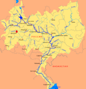
Map in Russian of the Volga

Satellite image of the mid and low Volga course

El Volga on a map of Russia


The first map shows the following cities in its course: Tver (Тверь), Ribinsk (Рыбинск), Yaroslavl (Ярославль), Kostroma (Кострома́), Kíneshma (Кинешма), Nizhny Novgorod (Ни́жний Но́в город), Волгогра́д) and Astrakhan (А́страхань). Likewise, in the satellite image, some of these cities also appear.
Gallery

Nilov Monastery, Seliguer Lake (Photograph by Serguéi Prokudin-Gorski, 1910)

Confluence of the Volga and the Kótorosl, a place to walk in the city of Yaroslavl

The iced Volga River, north of Yaroslavl

The River Volga in Tver
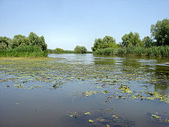
The river Volga near its mouth

The Volga in Uliánovsk


Hydrology
The Volga is fed 60% by water from melting snow, 30% by groundwater and 10% by rainwater. The Volga has an irregular regime, since half of the water that the river carries annually does so in a period of only six weeks: from the end of April to the beginning of June, at the time of the thaw, which begins in the southern part. of the basin, to spread rapidly towards the North. The level (water height) of the river is subject to significant annual fluctuations: it reaches 11 m in Tver; the 16 m before the point of confluence with the Kama river; and the 3 m at the mouth, in Astrakhan. However, the construction of reservoirs in its course and in that of its tributaries has made it possible to considerably reduce these fluctuations.
The interannual average production or module of the river is 182 m³/s in Tver; 1110 m³/s in Yaroslavl; 2,970 m³/s in Nizhny Novgorod; 7,720 m³/s in Samara; and 8060 m³/s in Volgograd. Downstream of Volgograd, the river does not receive any more significant tributaries and evaporation determines a decrease in its flow by 2%. The river flow could previously reach a maximum of 67,000 m³/s downstream of the confluence with the Kama River and 52,000 m³/s in Volgograd, with part of the water discharging into the surrounding floodplains. The annual rainfall in the basin is 187 mm in Volgograd, for a total rainfall received of 662 mm. Before the creation of the reservoirs, the Volga discharged 25 million tons of sediment and 40-50 tons of dissolved minerals in a year at its mouth. The waters of the Volga reach a temperature of 20-25 °C in July and remain ice-free 260 days a year in Astrakhan.
Economy
It was not until after World War II that the region really developed: more than 200 factories (tools, automobiles) were built in the main agglomerations. Gigantic adaptation works were undertaken on the Volga and its tributary, the Kama, to make permanent communication arteries, to produce electricity, and to irrigate the rainfed lands along its lower reaches. The exploitation after the Second World War of important oil and gas deposits throughout the basin (90 Mtes of oil and 28 million m³ produced during the year 2001) favored the creation of an important dynamic petrochemical industry, although the deposits They tend to run out today. The central part of the river basin is relatively fertile, although rainfall is very irregular from one year to the next. On the contrary, the attempts to irrigate the lands located further south did not give the expected results. In addition, a part of the arable land, located on the shore of the Caspian Sea, was flooded in the eighties, after the rise of the Caspian Sea level, which caught the specialists by surprise. The Volga basin is rich in mineral resources such as potash and salt. The Volga delta, as well as the approaches to the Caspian Sea, are rich in fish. Astrakhan, located on the Volga delta, is the center of the caviar industry.
Conditioning of the river course
In the course of the Volga, numerous dams have been built for hydroelectric use and flow regulation, so that practically hardly any undisturbed sections of the river course remain. Following the river downstream, the dams are the following (with year of entry into service, water surface, dammed volume, electricity production):
- Ivankovo dam (1937): 327 km2; 1,12 km3; 130 MkWh;
- Uglich dam (1940): 249 km2; 1.25 km3; 212 MkWh;
- Rybinsk dam (1941): 4550 km2; 25,42 km3; 1100 MkWh;
- Nijni Novgorodo (1955): 1591 km2; 8.7 km3; 1,513 MkWh;
- Cheboksary dam (1980): 2100 km2; 14,2 km3; 3280 MkWh;
- Samara dam (also a barrage of Kouïbychev, in confluence with the Kama River) (1955): 6450 km2; 58 km3; 11 000 MkWh;
- Sátov dam (1967): 1850 km2; 12.9 km3; 5400 MkWh;
- Volgograd dam (1958): 3317 km2; 32.1 km3; 11 100 MkWh;
Tributaries of the Volga
The Volga River has many tributaries, the most important being those listed in the following Table, arranged in a downstream direction. (The tributaries of the tributaries are ordered in the opposite direction, from the mouth to the source)
| Ramal | Affluent name | Destroying | Length (km) | Cuenca (km2) | Caudal (m3/s) | Tram. | ||||
|---|---|---|---|---|---|---|---|---|---|---|
| I | - | Selizhárovka River | Volga | 36 | 2950 | Higher Course | ||||
| I | - | Tvertsá River | Volga | 188 | 6510 | 60 | ||||
| - | - | Río Vazuza | Volga | 162 | 7120 | |||||
| - | - | Shosha River | Volga | 163 | 3080 | |||||
| - | D | Dubná River | Volga | 167. | 5350 | |||||
| I | - | Rio Medveditsa | Volga | 259 | 5570 | 25.2 | ||||
| - | D | Rio Nerl | Volga | 112 | 3270 | 12.8 | ||||
| - | - | Kashinka River | Volga | 128 | 661 | 4,5 | ||||
| I | - | Sheksná System—the Béloye—Kema—the Kémkoye—I Amdo—I Amdozero | Volga | 441 | 19 000 | 139 | ||||
| I | - | Río Suda | Volga | 184 | 13 500 | 134 | ||||
| I | - | Rio Mologa | Volga | 456 | 29 700 | 237 | ||||
| - | - | - | Chagodoshcha River | Rio Mologa | 242 | 9680 | 58 | |||
| - | D | Kótorosl River | Volga | 132 | 5500 | |||||
| I | - | Kostroma River | Volga | 354 | 16 000 | 71 | ||||
| I | - | Niomda River | Volga | 146 | 4750 | 28.9 | ||||
| I | - | Río Unzha | Volga | 426 | 27 800 | 158 | ||||
| I | - | Rio Uzola | Volga | 147 | 1920 | |||||
| - | D | Oká River | Volga | 1500 | 245 000 | 1300 | ||||
| - | - | - | Río Upa | Oká River | 399 | 9510 | ||||
| - | - | - | Rio Zhizdra | Oká River | 223 | 9170 | ||||
| - | - | - | Rio Ugra | Oká River | 399 | 15 700 | ||||
| - | - | - | Rio Protva | Oká River | 282 | 4620 | ||||
| - | - | - | Río Nara | Oká River | 158 | 2030 | ||||
| - | - | - | Río Osyotr | Oká River | 228 | 3480 | ||||
| - | - | - | Moscova River | Oká River | 502 | 17 600 | 250 | |||
| - | - | - | Rio Pronia | Oká River | 336 | 10 200 | ||||
| - | - | - | Rio Pra | Oká River | 192 | 5520 | 250 | |||
| - | - | - | Rio Mokcha | Oká River | 656 | 51 000 | ||||
| - | - | Rio Tsna | Rio Mokcha | 451 | 21 500 | |||||
| - | - | - | Tiosha River | Oká River | 331 | 7800 | ||||
| - | - | - | Seriozha River | Tiosha River | ||||||
| - | - | - | Kliazma River | Oká River | 686 | 42 500 | ||||
| - | - | - | Rio Teza | Kliazma River | 192 | 3450 | ||||
| - | - | - | Rio Nerl | Kliazma River | 75 | 53 000 | 400 | |||
| - | D | Kudma River | Volga | 144 | 2200 | Middle Course | ||||
| - | D | River Kérzhenets | Volga | 290 | 6410 | 19.6 | ||||
| - | D | Rio Surá | Volga | 841 | 67 500 | |||||
| - | - | - | Alátyr River | Rio Surá | 307 | 11 200 | ||||
| I | - | Río Vetluga | Volga | 889 | 39 400 | 255 | ||||
| - | - | - | Rio Usta | Río Vetluga | 253 | 6030 | 28 | |||
| I | - | Rutka River | Volga | 153 | 1950 | 7.32 | ||||
| - | D | Rio Tsivil | Volga | 173 | 4658 | 53 | ||||
| I | - | River Bolshaya Kokshaga | Volga | 297 | 6630 | 30 | ||||
| I | - | Rio Málaya Kokshaga | Volga | 194 | 5160 | |||||
| I | - | Rio Ilet | Volga | 204 | 6470 | |||||
| - | D | Sviyaga River | Volga | 375 | 16 700 | 34 | ||||
| I | - | Kazanka River | Volga | 142 | 2600 | |||||
| I | - | Kama River | Volga | 1805 | 507 000 | 3800 | ||||
| - | - | - | Rio Myosha (Mёша) | Kama River | 204 | 4180 | ||||
| - | - | - | River Shesma (Sunday) | Kama River | 259 | 6040 | ||||
| - | - | - | Río Viatka (Вяатка) | Kama River | 1314 | 129 000 | 890 | |||
| - | - | - | Rio Kilmez (Кильмезь) | Río Viatka | 270 | 17 525 | 84.6 | |||
| - | - | - | Pizhma River (Palestinian) | Kilmez River | 305 | 14 660 | ||||
| - | - | - | Rio Moloma (Morole) | Río Viatka | 419 | 12 700 | 79.1 | |||
| - | - | - | Cheptsa River, Chile | Río Viatka | 501 | 20 400 | 130 | |||
| - | - | - | River Letka (Léтка) | Río Viatka | 267 | 3680 | 20.6 | |||
| - | - | - | Kobra River (Кобра) | Río Viatka | 324 | 7810 | 55.8 | |||
| - | - | - | Rio Zaj (Zia) | Rio | 270 | 4540 | 16.9 | |||
| - | - | - | Rio Iž (originally) | Rio | 259 | 8510 | 34.1 | |||
| - | - | - | Rio Ik | Kama River | 571 | 18 000 | 45.5 | |||
| - | - | - | Belaya River (Belaya River) | Kama River | 1430 | 142 000 | 858 | |||
| - | - | - | Rio Sjun (Сюнь) | Belaya | 209 | |||||
| - | - | - | River Bystry Tanyš or only Tanyš (Tyâà ́nыpi) | Belaya | 345 | 7560 | ||||
| - | - | - | Rio Dema (Diёма) | Belaya | 535 | |||||
| - | - | - | Rio Ufá (Караидель) | Belaya | 918 | 53 100 | 388 | |||
| - | - | - | Rio Yuriuzán (шрюзань) | River Ufá | 404 | 7240 | 55 | |||
| - | - | - | Ay River (Ae) | River Ufá | 549 | 15 000 | ||||
| - | - | - | river Sim (Сим) | Belaya | 239 | 11 700 | 47.9 | |||
| - | - | - | Rio Inser (Years) | Rio Sim | 307 | 5380 | ||||
| - | - | - | Rio Nuguš (Нугуш) | Belaya | 235 | |||||
| - | - | - | Siva River (Сива) | Kama River | 206 | 4870 | ||||
| - | - | - | Chusovaya River (CHESDA) | Kama River | 592 | 23 000 | 222 | |||
| - | - | - | Rio Sylva (Сылва) | Chusovaya River | 493 | 19 700 | ||||
| - | - | - | Rio Iren (Iraq) | Rio Sylva | 214 | 6110 | ||||
| - | - | - | Rio Usva (рсьва) | Chusovaya River | 266 | 6170 | ||||
| - | - | - | Rio Obva (United Nations) | Kama River | 247 | 6720 | ||||
| - | - | - | Rio Inva (Iraqa) | Kama River | 257 | 5920 | ||||
| - | - | - | Kosva River (Косьва) | Kama River | 283 | 6300 | 90 | |||
| - | - | - | Jajva River (Azuvi) | Kama River | 304 | 6250 | ||||
| - | - | - | Río Víshera (Виашера) (Vishera-Kolva system reaches 520 km) | Kama River | 415 | 31 200 | ||||
| - | - | - | River Kolva | Víshera River | 460 | 13 500 | 457 | |||
| - | - | - | Yazva River | Víshera River | 135 | 5900 | ||||
| - | - | - | Kosa River (Коса) | Kama River | 267 | |||||
| - | - | - | Río Vesljana (Весляна) | Kama River | 266 | 7490 | ||||
| I | - | Bolshói River Cheremsán | Volga | 336 | 11 500 | 36.1 | Inferior course | |||
| - | D | Rio Usa | Volga | 76 | 2240 | 16.1 | ||||
| I | - | Rio Sok | Volga | 364 | 11 700 | 33.3 | ||||
| I | - | Samara River | Volga | 594 | 46 500 | 47.2 | ||||
| - | - | - | Buzuluk River | Samara River | 248 | 4460 | 7.7 7.7 | |||
| I | - | Chapayevka River | Volga | 298 | 4310 | 2.53 | ||||
| I | - | Rio Mali Irgiz | Volga | 235 | 3900 | 6.4 | ||||
| I | - | Rio Irgiz (or Bolshoi Irgiz) | Volga | 675 | 24 000 | |||||
| - | D | Rio Terioshka | Volga | 213 | 9710 | 17,5 | ||||
| I | - | Río Yeruslán | Volga | 278 | 5570 | |||||
| - | - | Ajtuba River (Volga branch) | Volga | 537 | 153 | |||||
Contenido relacionado
Annex: Municipalities of the province of Segovia
The Savior
Frankfurt (disambiguation)