Vichada
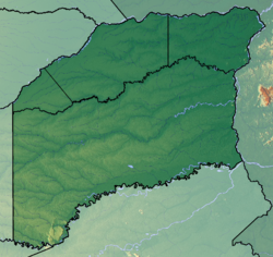
Vichada is one of the thirty-two departments that, together with Bogotá, Capital District, make up the Republic of Colombia. Its capital is Puerto Carreño. It is located in the east of the country, in the Orinoquía and Amazonia regions, bordering Casanare and Arauca to the north, Venezuela to the north and east, Guainía to the south, Guaviare to the southwest, and Meta to the west. With 100,242 km², it is the second largest department —behind Amazonas—, with some 116,944 inhabitants in 2023, the sixth least populated and with 1.15 inhabitants/km², the second least densely populated, ahead of Guainía. Within this department is the El Tuparro National Park.
History
At the time of the arrival of the Spanish conquerors, several indigenous groups were found in Vichada, some of which still exist today; Among them are the Guahibos of the Guahibo linguistic group, the Curripacos and Piapocos, of the Arawak linguistic group, and the Cuivas, Desanos, Puinaves and Salivas. In order to survive, these natives have had to endure all sorts of harassment, which have made them move to habitats less conducive to survival.
From colonial times until the middle of the XIX century, the current territory of Vichada belonged to the province of Bogotá; during Gran Colombia (1819-1830), it was part of the department of Boyacá; Between 1831 and 1857, together with Meta, it constituted the Territory of San Martín; in 1857, it became part of the Sovereign State of Cundinamarca; in 1867 it began to be administered directly by the national government under the name of Territory of San Martín; Vichada came to life as an independent entity in 1913, the year in which the Vichada police station was created by decree 523, segregated from the jurisdiction of the Municipality of Meta.
When Vichada was created, its capital was established in front of the Raudal de San José de Maipures. Politically-administratively, the Special Police Station was made up of the municipality of Maipures and the corregimientos of San José del Vichada and Empira. On June 12, 1924, through Decree 1021, the capital was moved to Egua (today Puerto Nariño), at the mouth of the Vichada River, and the municipality of Orinoco was created. On June 5, 1974, the National Government definitively transferred the capital to the municipality of Puerto Carreño, the administrative center of Vichada founded in 1922 by General Buenaventura Bustos, the first Commissioner of Vichada. Finally, on July 4, 1991, the National Constituent Assembly elevated Vichada to the category of special department, reaching its full powers as a department as of 1995.
Geography
The department of Vichada has an area of 100 242 km². It is located in the eastern region of Colombia, on the left bank of the Orinoco and the right bank of the Meta river in the so-called altillanura, since the drainage of the right bank of the Meta river is towards the Orinoco and not towards the Meta. The Meta River forms its northern border with the Colombian departments of Casanare and Arauca, and with the Venezuelan state of Apure, the Orinoco River its eastern border with the Venezuelan state of Amazonas, and the Guaviare River its southern border with the Colombian department of Guainía..
Limits
To the north it is bordered by the Meta River, which separates it from the departments of Casanare and Arauca, and from the Venezuelan state of Apure. To the east it limits with the Orinoco River that separates it from the Venezuelan state of Amazonas. To the south with the Guaviare River that separates it from the departments of Guaviare and Guainía. Finally, to the west its border forms a straight line between the Gauviare and Meta rivers, which separates it from the department of Meta.
Physiography
The relief of Vichada is made up of extensive plains belonging to the Eastern Plains of Colombia, which extend from the foothills of the Eastern Cordillera to Venezuela, over the Orinoco River basin known in Colombia as Orinoquía.
In the department there are rocky outcrops of the Guiana shield, there are active dunes and fossils. Due to the flora present in the plains, in summer there are fires that are almost always caused by human action. Vichada is characterized by being covered by vegetation typical of the plains to the north of the Vichada River, and by tropical forests to the south of it.
The soils are relatively poor because they do not receive Andean alluvial contributions since the original courses of the Tomo and Vichada rivers, which originally came from the Eastern Cordillera of Colombia, were "decapitated" by the Meta river itself and one of its tributaries as it deviates to the left. It is not really a capture phenomenon but a typical course change in a plain region. Nor does the existence of a fault in the area seem to be very important, since the greatest relative height in the department's territory was achieved in the geological past, with the contributions of sediments from the Andes. In any case, the existence of a fault line is very evident, but it is located much closer to the mountain range itself, in the foothills. What happened, also during the geological past, is that, as the Andes rose, the Colombian-Venezuelan Llanos basin progressively sank (as happens in all sedimentary basins) and this subsidence was much greater in the lower part. of the Apure state, with which the waters of the Meta ended up being diverted towards those lower areas.
In the central region of the department and close to the Vichada river is the Vichada structure, a presumable impact crater that, if confirmed as such, would probably be the largest impact structure in South America.
Hydrography
The hydrographic network of Vichada is made up of large rivers, streams, pipes and some lagoons, which drain into the Orinoco through the Meta, Vichada, Guaviare and Tomo rivers; In addition to those already mentioned, the Bita, Tuparro, Uvá, Elbita, Muco, Iteviare and Siare rivers, and the Tuparrito, Bravo and Mono pipes also stand out. The most important lagoons are those of Sesama and Caimán.
Political-administrative division
The department of Vichada is divided into four municipalities: Puerto Carreño (the capital), La Primavera, Santa Rosalía and Cumaribo. In addition to these municipalities, the department of Vichada has several reservations and indigenous settlements of great importance for the region.
Demographics
| Evolution of the population of the department of Vichada (1938-2023) |
 |
Population by census.Population by projection.Source: Statoids. DANE. |
Ethnic composition
According to the figures presented by DANE from the 2005 census, the ethnographic composition of the city is:
- Mestizo and white (52.8%)
- Indigenous or Amerindians (44.4%)
- Afro-Colombians (2.8%)
Economy
The department's economy revolves around agricultural activities, mainly forestry and livestock farming on a very low productive scale, as well as extensive livestock farming (vaccination stands out) and extractive activities. The El Tuparro national natural park, the Gaviotas center and the Marandúa project, in addition to being great attractions, constitute plans to improve the quality of life in the department. Due to its geographical isolation, there are illegal coca leaf plantations, a raw material for the elaboration of alkaloids such as cocaine, whose trade and distribution is penalized by the Colombian state, which has allowed groups outside the law to seek to take control of this business, which has earned them confrontation with the Public Force. Important deposits of coltan have been found in the subsoil of this department, but not enough to justify large-scale exploitation; However, illegal armed groups and informal adventurers seek to take advantage of the million-dollar profits from the sale of this mineral abroad by exploiting it illegally, for which reason the Colombian government has declared these reserves "of strategic interest", prohibiting its exploitation even legally.
Places of interest
- Natural National Park El Tuparro
Contenido relacionado
Constitutional Court
Annex: Municipalities of the province of Huesca
Length


