
Valera
Valera is a city in Venezuela located at the foot of the Andes in the Trujillo state in the west of the country. It is the capital of the homonymous municipality and is located 540 m above sea level. n. m. (height measured in the city center in Plaza Bolívar with GPS positioning) and has an area of approximately 20 square km. It is located on an Andean alluvial terrace with straight edges. The Motatán and Momboy rivers border the city, the latter gives its name to the famous and picturesque Momboy Valley on the way to the town of La Puerta at 1800 m above sea level. n. m. It is located between the coordinates 9°02'00", 9°21'00" North latitude and 70°36'00", 7°43'00" West longitude. In addition, it is located approximately 33 km from the city of Trujillo, the state capital. It is connected by the Valera-Trujillo Interurban Highway or Highway " General Cruz Carrillo", expressway with 3 channels per side, in addition to the shoulder, which is familiarly called " Road Axis" being the only highway that the entity has.
The city has an average temperature of 27 °C (INAMEH). Known as "The City of the Seven Hills" It is the most important town in the state of Trujillo, above the Capital, thanks to the commercial and industrial activities that make life in the area. It has a population of approximately 173,000 inhabitants. for 2018 and the state of Trujillo about 900,000 inhabitants according to official figures from the INE; and the population of its metropolitan area (Valera, Carvajal) is 200,000 inhabitants. approximately for the year 2018, corresponding to the Valera and San Rafael de Carvajal municipalities.
Geography
Valera is located 540 m above sea level. n. m. (height measured in Plaza Bolívar in the center of the city), between the Momboy and Motatán rivers; It is also located about 33 km from the state capital, Trujillo de Nuestra Señora de la Paz. It has an average temperature of 27°C. It is a crossing point on the roads that lead to the City of Mérida, Maracaibo (second city in Venezuela) and Barquisimeto (fourth city in Venezuela), which speaks of its privileged location. Its estimated population for 2015 based on projections from the last census in 2011 is 165,848 (city) and for 2020 in its bicentennial year 173,769. For the year 2030, the population projection amounts to 186,012 inhabitants (3)
Climate
Valera is located at an altitude of 540 m above sea level. n. m. on a river valley above a terrace open to the action of the NE winds, of a certain humidity, at the same time that it is subject to the descending winds of the mountain range. The temperature is warm, modified by its altitude, having an average temperature of 28 degrees. The extreme maximums should not exceed 35 °C and the extreme minimums should not fall much below 18 °C, with the average temperature being about 28 °C. The first of these temperature minimums occur in the early mornings of January and February and the second in the daytime from April to October. The average annual precipitation reaches 1,016 mm with extremes of 1,249 and 792 mm and the volume of precipitation is quite regular from one year to the next.
| Month | Ene. | Feb. | Mar. | Open up. | May. | Jun. | Jul. | Ago. | Sep. | Oct. | Nov. | Dec. | Annual |
|---|---|---|---|---|---|---|---|---|---|---|---|---|---|
| Temp. max. abs. (°C) | 31 | 32 | 31 | 32 | 33 | 32 | 33 | 32 | 32 | 33 | 31 | 30 | 31.8 |
| Average temperature (°C) | 29 | 30 | 30 | 31 | 31 | 29 | 30 | 30 | 29 | 31 | 29 | 28 | 27.2 |
| Average temperature (°C) | 21 | 23 | 23 | 23 | 23 | 24 | 23 | 24 | 23 | 25 | 22 | 22 | 23 |
| Temp. medium (°C) | 16 | 17 | 18 | 19 | 18 | 18 | 19 | 18 | 17 | 18 | 17 | 16 | 17.6 |
| Temp. min. abs. (°C) | 15 | 15 | 17 | 16 | 17 | 16 | 16 | 17 | 17 | 16 | 15 | 14 | 15.9 |
| Rains (mm) | 76 | 60 | 135 | 105.5 | 204.8 | 60 | 65.4 | 179.1 | 156.6 | 90.7 | 63 | 62 | 1258.1 |
| Days of rain (≥ 1 mm) | 10 | 9.5 | 15 | 16 | 22 | 15 | 16 | 20 | 19.5 | 17 | 15 | 12 | 187 |
| [chuckles]required] | |||||||||||||
History
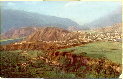
Homes of the city (of a postcard of the 50s)

Photo of the 90s of the 20th century
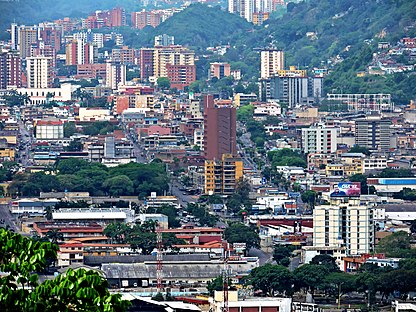
Valera from Carvajal

Valera from Carvajal

Night photography of the city from the Ave. Bolivarian

Air photography of the city


Valera takes its name from the encomendero Marcos Valera. The year of its foundation is not known for certain, although several historians agree that it was August 25, 1811. Others say that it was in 1817 on land owned by Doña Mercedes Díaz de Terán and Dr. Gabriel Briceño.
Although it is said that Valera was born as a city without a defined date, only its elevation to a parish in 1820 by Bishop Lasso de la Vega is considered a historical reference. Colonel Agustín Codazzi, the traveling geographer who dearly loved the state of Trujillo, mentions Valera as a parish of Escuque.
It is known that El Libertador passed through the town on his way to Trujillo (Venezuela) to sign the famous “Decree of War to the Death” in those turbulent times of republican history.
Its first newspaper that circulated regularly was the Diario de Valera, directed by Dr. José María Colina in 1900. The first public registrar of the city was Fabián Salas.
Almost dormant during its first 100 years and slowly expanding across the Andean terrace on which it is located, its growth was slow but important, perhaps becoming the city with the greatest commercial development in the area until a few years ago, when began to lose importance with respect to its Andean peers of Mérida and San Cristóbal.
Its location is privileged for its commercial and industrial development, as it is an intersection point between the Mérida - Maracaibo - Caracas - San Cristóbal roads. For this reason, they made it a mandatory destination for everyone who was looking for something, they made it “news” in Venezuelan events.
Valera in 1853 was the victim of a terrible epidemic, which left it practically alone as its inhabitants fled to neighboring towns. But the city was quickly reborn and gained light and commercial boom. Tradition places the romantic Valera as the one that decorated its streets with arches full of flowers, flagged its houses on historical and religious days such as July 24 and Corpus Christi, those of the moonlight serenades, the lyrical city. where Laudelino Mejías conceived the unforgettable waltz “Conticinio”.
Valera has been the cradle of significant values, among which Ana Enriqueta Terán, Adriano González León, Víctor Valera Mora, José Antonio Abreu, Ángel Sánchez, Juan Carlos Chirinos, Omar Lares, Jesús Muchacho Bertoni stand out, as well as adopted children, among them José Antonio Tagliaferro, Rafael Gallegos Celis, Américo Briceño Valero, Domingo Giacomini, Pompeyo Oliva, Vincenzo Clerico, Ignacio Burk, Rafael Isidro Briceño, Francisco Fernández Galán, Pedro Emilio Carrillo and the linguist Natalia Rossi de Tariffi, who in her book “America fourth dimension: the Etruscans left the Andes”, exposes the science of lexicogenetics, which unravels and finds the original meaning of words.
Among its notable constructions are the San Juan Bautista Church, a neo-Gothic style temple created under the direction of the Pbros. Guillermo José Parra and José Humberto Contreras affectionately called "The Cathedral" although it is not because the cathedral is in Trujillo, the state capital and seat of the bishopric. St. John's Church has a twin church in a town in Italy. One of its oldest and most resistant bridges is the one built over the Motatán River on the road that leads to Carvajal and Trujillo. It was built in 1934 by the civil engineer and master builder Ángel Tognetti. It was inactive for about two years while it was rebuilt, having been reopened in 2013.
Valera has modern commercial buildings, an Athenaeum, Hotels, Avenues, the Parque de los Ilustres, the Agricultural Fair Park and the Botanical Garden located in the La Beatriz sector separated from the main town of Valera by a viaduct (José Antonio Paéz) hero of the independence of Venezuela. The modern city extended its arms through the sugarcane fields of La Plata, San Luis and Morón, in the northern part. To the south, the cacti and creeping vegetation were eliminated, creating first the Las Acacias Urbanization and then La Haciendita, La Esperanza, El Country and El Gianni. Los Ilustres Park does not meet expectations in terms of size and two new parks are being promoted: one in the Cañón de las Acacias next to Avenida Bolivariana adjacent to the hill, which in turn should be decreed a natural monument and protective zone of Valera. The other should be on the sides of the new Avenida Bicentenario and called Parque Metropolitano as promoted by the late Dr. Bazó.
To the east it became populous in the El Milagro neighborhood, and to the west it sprung up neighborhoods in the hills, on the hills and in the San Antonio Urbanization.
The Seven Hills
Valera is located in a valley surrounded by seven hills - like Rome, Italy - stony and sandy watchdogs that have been losing their mountain greenery to become overpopulated and become neighborhoods bordering the plain of the great metropolis; heights from where you can observe the cosmopolitan city from all cardinal points.

- Colina La Concepción: (Cerro La Concepción or Cerro a Juro) is located on the border of Calle 08, (called Calle Motatán) bordering the Point of Merida (Calle 08 with Avenida 04) and continuing to the southwest (Barrio El Milagro). Its name is due to the fact that there were several midwives (seven midwives) in that place that attended home births when the doctor was not close or unavailable at the clinic in the sector. This name is also accepted by virtue of religious faith and veneration to the Immaculate Conception of Mary of Nazareth. This motto adjacent to Cerro La Pollera in a fork in front of 08th Street in its blind spot, called Calle Motatán.
- Colina La Pollera: (Cerro La Pollera) starts at 17th Street and lowers ten more streets to be located as border before Avenues 02-03-04, reaching the Point of Merida, in the convergent corner of Avenida Cuatro and Calle 08, following the southwest to the limit with Cerro La Concepción at a blind point of the beginning of 08th Street. its name is due to the fact that when the expansion of the city begins with the purchase of the San Pedro Plain (1891), there was a poultry farm (or plumbing farm), which supplied the necessary birds to the city for domestic consumption (pollus, hens, birds, geese, ducks). More towards the south-west, this hill (without populating) extends towards today Bolivarian Avenue, adjacent to the viaduct that communicates with La Beatriz.
- Colina La Cruz: (Cerro La Cruz) located northwest, at the end of Calle 07. From this summit you can see 50% of the city. It is the motto seen from Bolivar Square and that majestically rises as a giant vigía. Its name is because in the pope and looking at the city, it was installed a Cross of the Mission (1951) of about four meters high in order to venerate it every 3 May. He wears, puts incandescent lights and makes it the Rosary to the Cross of May. Its visibleness is a cultural attraction that identifies and can be observed and admired from all the streets. The construction of a park has been proposed to operate as a protective area of the city and the area, as well as the hill itself, which would be located on its skirts next to the Bolivarian Avenue to which it is next. This proposal for 2019 is being evaluated to be one of the works of the Bicentennial of the city.
- Colina El Cementerio: (Cerro El Cementerio or Cerro El Quemador) is located west of the city, via Escuque and Betijoque. It is all the hill that borders to the left the municipal cemetery and that begins by adjoining Las Mercedes towards the exit for La Floresta; it covers the edge of the municipal cemetery; at the back it limits the 16th Street and the border to the south in the area of San José (behind the avenue Bolívar Sector Las Acacias and which connects with the Cerro La Caja de Agua and culminates in the entrance of the Cienfuegos Neighborhood). His name is because it is the front of the cemetery of the city and forty years ago there was also the garbage burner.
- Colina La Cabaña: (Cerro La Cabaña) is located south, towards the right of the city, going up Bolivar Avenue – Las Acacias- Mendoza. It erases the San José Sector and communicates with Escuque on a road that begins at the La Esperanza Service Station. It is a rural area of the city, very populated. His name is due to the fact that in times of the colony he was released to Black Norberto, a warmer benefited by his work and dedication to his master. As he had nowhere to go, he rode up the hill and built for himself a great cabin where he lived a long time. It was its property where it sowed agricultural items of all kinds and sold them or changed them in the city, such as modus vivendi. During their stay they went to dwell in the surroundings of that mountain other more labriegos until they formed a small village. The first house gave the name to the site.
- Colina La Plata: (Cerro La Plata, Cerro Morón or Cerro Evangélico) located in front of the Fire Department; this hill is limited by the end of Avenida 09, Sector El Bolo, the Municipal Market and the Morón Urbanization. Its name is due to the fact that the entire plain at the foot of this hill were land of the Gran Hacienda La Plata, with ramifications towards the east and northeast of the city; it is another of the very populated rural sectors. Communicate on roads and stairs with Morón, San Isidro, with the street of the municipal market and the end of the avenues 09 and 10 at the start point of La Marchantita on its back street with El Bolo. The appeal of Cerro Morón is because to the west it is facing this urbanization. And the Gospel is because in recent times they built an evangelical temple where the services of their believers are offered.
- Colina La Ciénaga: (Cerro La Ciénaga) located a little lower than Cerro La Cruz, the end of Calles 04,05,06; it limits Avenue 16, heading towards Lasso La Vega in the boundary sectors of the Ambulatory of Lasso La Vega. Its name is because about fifty years ago there was a lagoon that served to wash clothes and bathe, but that when it rained toretally the whole sector became a whole swamp (or a swamp) between mud, water and smaller mountain. It is commented that in the beginning there were caymans, buckles, wild animals of the mountain and beautiful claws and birds beaking in search of food. these seven hills are fundamental to Valera so it is called the city of the seven hills each hill has a different location
Places of interest

- St. John the Baptist Church: is a Gothic-style religious building, designed by Jesuit priest Luis Yogorza. Its construction began in 1927 and culminated 26 years later in 1953. It has twin towers similar to the cathedral of Cologne that rise to 47 meters high, making it the highest church of all Venezuelan Andes. On its side ships and on the apse you can admire 62 stained glass windows made in Munich, Germany, brought after World War II. It is a tourist attraction of the city in front of the emblematic Plaza Bolívar de Valera.
- Plaza Bolívar: public space built in 1954 by Luigi Pandini, located between 10th and 11th Avenues with 7th and 8th Streets and extends over an area of 1 000 square meters. It includes green areas with fruit trees, palms and gardens while the fauna present is made up of squirrels, pigeons, iguanas and lazinesses, sheltered in a closed perimeter with a 1 metre high gates.” In the center of the square the original marble pedestal, iron luminaries and a glorieta; and the statue of Simon Bolivar in scale to its real size made in bronze.
- The Murachi Towers: is a residential and commercial set consisting of three 20-storey towers each of the three towers are 100 meters high the Murachi towers are south of the city of Valera are the highest towers of the Venezuelan Andean region. The construction of these towers begins in the mid 80's when the urban expansion begins in the city of Valera.

Casa Carmania, important historical corner of the country. - Libertad Theatre: characterized by the presence on the facade of an immense wall of polychrome mosaic art Decó style that shows a great deterioration. The room where cinematographic films were previously projected, today is the commercial venue for a department store. The reconstruction of the mural is being proposed in 2015. No one has assumed such a project and there are only ideas. It is rumored that this theater has that name because at its inauguration was attended by Mexican actress Libertad Lamarque and in her honor it was named so

Plaza Shopping Center.


- Teatro Ana Enriqueta Terán: In honor of the Venezuelan poet born in Valera, he has become a meeting place for believers in the Evangelical Church. Its previous name was that of Teatro Valera who with Liberty were the two cinemas around Plaza Bolívar.
- Plaza Sucre: the centenary square was built on July 4, 1903 by the aegis of the illustrious trujillano Américo Briceño Valero (1877 – 1955), who called it “Plaza de la Concordia”. Four years later the City Council changed the name to Plaza Araujo in homage to the “Leon of the Cordillera” the Andean general Juan Bautista Araujo (24 June 1833 – 11 February 1898). The Institute of Cultural Heritage, in its patrimonial catalogue of the Trujillo state, refers that at the beginning of the centuryXX. the square was used as a velodrome to perform cycling tests, but when they were made fences, they planted trees and conditioned with benches and lighting, the Municipal Chamber called it Mariscal Sucre Square.
- San Pedro Church: religious construction inspired by the Romanesque architecture, was founded in 1953 with capacity for 1500 people located south of the Plaza Sucre de Valera. In 1946 Father Humberto Contreras constituted a meeting of neighbors in order to manage the creation of a new parish, works that began on June 29, 1948, the day of Saint Peter and Paul. The construction inspired by the Church of Saint Peter of Rome occurs in the midst of the urban development that Venezuela experienced in the mid-centuryXX..
- Parque Los Ilustres: large parking space located between the 27th and 28th streets adjacent to Bolívar Avenue. It is practically the only green area that the valeranos take advantage of to spend the morning and afternoon. It is a green area very used to walk, trot, meeting place to do aerobic exercises and to play children. It is already insufficient because more than a park is a large square and it has been proposed to build two new parks on Bolivarian Avenue and Bicentennial Avenue even without official response.
- Casa de Carmania: constitutes the main house of the hacienda of Father Francisco Antonio Rosario, who gave accommodation on 12 and 13 June 1813 to the Liberator of the Patriarch who arrived in Merida with the patriotic army. It is worth noting that in it Simon Bolivar, as a great strategist, conceived his Proclamation of War to Death together with the owner of the place, which was subsequently signed in the city of Trujillo. There is a campaign to turn it into a museum and park area. At present, a juvenile correctional facility should be relocated to be used as a tourist area. This house was declared a Historic Monument of the Nation on August 20, 1963. Currently, there is the headquarters of the Foundation for the rescue, conservation and dissemination of the historical values of the Trujillo State.
- Estadio José Alberto Pérez: the largest stadium in the Trujillo state with a capacity for 30,000 spectators is seat of the Trujillanos Football Club. It has the particularity of having been built in several stages and its tribunes unfortunately have no harmony in their architecture.
- Tulene Bertoni Anthropological Museum: became a museum on May 20, 1976, in the center of the city, located at the headquarters of the Anticancerous Society, on Calle 6 with Avenida 13 near the "Pedro Emilio Carrillo University Hospital", where it remains open to the public at a time of 7:30 to 16:30. It has 116 original paleontological samples, 787 pre-Columbian pieces of ceramic and stone, 162 pieces of carvings of colonial times, altarpieces of domestic worship, paintings and ancient photographs, distributed in its five rooms "Salvador Valero", "Arte Colonial", "Archeology", "Numismatic" and "Paleontology".
- Edivica Shopping Center: This is the mall that is located throughout the city center being one of the oldest in it, its amazing construction has made it last in perfect condition throughout the years. It is the most popular shopping center in the city because, despite not being the largest one, being in the central area of the same own and visitors arrive at their doors easily. Parking facilities in the shopping centre and nearby. Currently the deterioration of the surrounding areas by the proliferation of unchecked street vendors has made it lose its original splendor
- Centro Comercial Plaza: recreation site, shopping and entertainment. Started in 1999 and opened in 2001, it is the largest shopping centre in the state and the second in the Andean area with modern shops, 3 fast food fairs, supermarket and five digital cinema rooms and one in 3D (sala 5) of a national film chain. Built in a way that is currently made up of three mall interconnected by a 2-level glazed bridge. Located in the Las Acacias sector, specifically between Avenidas Bolivar and 6. Large parking lot on the sides and on the front.
- Centro Comercial El Recreo: on Avenue 5 with street 19. It hosts the famous Locatel chain and other shops, medical clinics and offices. A fast food fair. Covered parking with rise by wide ramp.
- Centro Comercial Diego Andrés: located on Avenue 5 between 11th and 12th Streets, it is home to a large number of medical offices, laboratory, counter offices and other businesses including a stationery.
- Centro Comercial Canaima: located in the center sector one block below the Plaza Bolivar. It has several types of businesses and there are offices of professionals especially doctors, travel agencies, Agent Zoom-DHL, Cybercafe.
- Centro Comercial Virgen del Cármen: located on the side of the church of the same name. It is modern construction (2014) and three floors. He has a food fair.
- Arichuna Shopping Centre: important shopping center where were the missing offices of Movistar and Directv who left the city of Valera. Currently there are sales of spare parts, cafes, insurers, beauty rooms and other businesses.
- Centro Comercial Las Acacias: one of the oldest where there was a shop of the missing VAM Store Chain. Currently, the main offices of the CANTV government telephone company and the Hidroandes offices as well as numerous offices of lawyers and other professionals as well as two bank offices operate there.
- Bolivarian Forum: This magnificent modern-style construction is part of a tourist, cultural and educational complex, was opened in 2005 by the then State Governor Gilmer Viloria. It has a wonderful window that pays homage to the Liberator Simon Bolivar on the occasion of the oath on Mount Sacro. It belongs to the state and is used mostly for official acts. Found at the intersection of Viaducto towards La Beatriz with Bolivarian Avenue.
- Mendoza Fria, La Puerta and Lagunita: picturesque towns of the Municipality Valera located 10 minutes from the other, with high mountains and crystal clear waters, broken and green. In La Puerta the tourist will find crafts, culinary art and floriculture; it is located 21 km from Valera. Those adventurous avid can choose the old waterways which will lead you to the beautiful adjoining moors and magical lagoons nestled in the Andean mountain range, in turn they will appreciate natural polychromy and agricultural development. Lagunita, leaving at the end of La Puerta, is a town that is reached by a beautiful mountain road similar to that which goes to Valle Grande in Mérida. Unfortunately there is no place to stop for coffee or visit handicrafts as well as no theme park. Upon arrival, the opportunity for a boat ride, in canope and on horseback will be opened in addition to spending a morning or afternoon with its various natural attractions thanks to its cosy mountain climate.
Communication routes
The city can be accessed by air through the modern Antonio Nicolás Briceño National Airport with its 2,100 m long runway, suitable for medium-range jets such as Boeing 737, Airbus A300 and Embraer 190. It has night markings. (I had 3 flights a week until April 2015). At the beginning of 2018, the airport is completely inactive (since 2015) for commercial flights and only private small planes arrive, depriving the city and the State of this important benefit for communication and tourism.

Today the most important urban avenues in the city are Avenida Bolívar, considered the spine and most important and congested avenue; Bolivariana Avenue, taken as an alternative route mainly for the inhabitants of La Beatriz Parish; and Bicentenario Avenue, the newest, fulfilling the objective of allowing residents of the Escuque and Rafael Rangel Municipalities to pass to other towns in the State without having to enter the center of Valera. Calle 17 also stands out for its width and with 4 canals, Calle 22 that leads to the Beatriz Viaduct and an important work that connects with the urbanization of the same name. It is important to note that the city requires new roads from south to north and from east to west. The Salesiano School was unfortunately located during its construction in the late 1950s in such a way that it cut off 3 avenues from north to south. One of them (the connection of Ave 4) can be reopened without the need to expropriate or demolish any home. Bicentennial Avenue (photo)
Likewise, the city is connected to the capital of the State, the City of Trujillo, by an interurban highway (the only one in the State) called General Cruz Carrillo. This road meets the requirements of a fast track without intersections or traffic lights with two circulation channels plus a shoulder of stops and three more shoulders in some sectors.
The city has communication with the City of Mérida through the trans-Andean highway through the moor, via Pico del Collado del Cóndor (Águila), at 4,100 m above sea level. n. m., which is the highest road point in Venezuela, along the Pan-American highway towards the city of El Vigía and with the cities of Maracaibo along the route taken by the Lara-Zulia highway and along the eastern coast of the lake towards Ciudad Ojeda and Lagunillas. Towards Barquisimeto and Caracas and the center of the country taking the Lara-Zulia highway.
Economy

The city has always maintained a great commercial exchange with the surrounding areas both outside and inside the state, which is why it has branches of almost all the large banks in the nation, some with up to three branches. The largest banks with the greatest number of agencies are Venezuela (government) and the Mercantil, Provincial, Banesco and Occidental discount banks (BOD). There are representations of large franchises worldwide such as McDonald's and Subway, Courier agencies (Zoom, DHL and MRW), car agencies of companies present around the world such as General Motors, Ford, Toyota, Chrysler, Volkswagen, Hyundai and Fiat. (Many of these agencies have closed due to the national automotive crisis situation). The city has important businesses, including large hardware stores, cell phone companies with their regional service centers such as Digitel (own service center), and Movilnet (own service center) and Movistar (left the city in 2016 and took away their offices, leaving only authorized agents) shoe stores and clothing and appliance stores. In the construction industry, high-caliber companies such as Vinccler, Fernández Galán, and Ediviagro stand out.
Large shopping centers such as the Plaza Shopping Center demonstrate the vitality of the city and its growth potential. It has three malls, interconnected 1 and 2 by a two-level skybridge with steel and glass walls and which has become an icon and reference point of the city. It also has the only active movie theaters, 5 in number, very modern and stadium-type, with a 3D projection room. Other important shopping centers are Edivica on Avenida Bolívar between 7th and 8th streets, Arichuna on the same Avenida Bolívar, Monte Casino on 18th street, Las Acacias Shopping Center, Virgen del Carmen in the northern area, El Recreo on 5th avenue New shopping centers such as Canaima, Diego Andrés, and the Caravaggio shopping center, all in the central area, and Plaza Centro will revitalize the central part of the city, which is very abandoned. There are also important services in the health area, the presence of two large urban hospitals and important clinics that offer private health services and employment to a large number of people. Among these health centers, the Dr. Pedro Emilio Carrillo University Hospital (HUPEC) and the Dr. Juan Motezuma Ginnari Social Security Hospital located in Beatriz stand out. The large private health centers include the Valera Medical Institute (IMV), the María Edelmira Araujo clinic, the UGA, the Los Ilustres clinical center, the Dr. José Gregorio Hernández Clinic and the former Rafael Rangel Policlínic. There is an Industrial area to the north of the city with a large number of warehouses, warehouses, and some medium-sized industries such as mattress factories and other more important ones such as the Diario de los Andes media outlet and the Polar companies at the distribution level. The Coca Cola company and previously PepsiCola had an important bottling plant that was closed.
Education
The city has public and private universities, institutes of higher education and technology, public and private high schools for secondary education, primary and preschool schools.
The most well-known and famous University based in the city is the Universidad Valle del Momboy (UVM) with its main headquarters in the Carvajal municipality called Estovacuy headquarters and in the Mirabel Urbanization called Mirabel headquarters, which belongs to the metropolitan area of Valera.. There is also the extension of the Simón Rodríguez National Experimental University (UNESR), and the extension of the Rafael María Baralt Experimental University. The University of Los Andes has the Valera Extension Faculty of Medicine, the only one in the state of Trujillo, which is based next to the Dr. Pedro Emilio Carrillo University Hospital. Likewise, there are university postgraduate degrees in various medical specialties under the tutelage of the University of Los Andes. Other important educational institutions in Valera are the Mario Briceño Iragorry University Institute of Technology (IUTEMBI) and the Mario Briceño Iragorry Territorial Polytechnic University of the State of Trujillo (UPTMBI) (4). Likewise, the Rodolfo Loero Arismendi Institute of Technology (IUTIRLA) is based in the La Beatriz parish.
Transportation
Buses
The public transportation service of the City of Valera is made up of small buses and the popular "busetas" They are nothing more than old VAN-type trucks from the 80s, not in very good condition. In total there are 5 municipal lines: two being the most used (Popular Line and Line 48) for having routes to the places of greatest interest in the city; Others to mention would be Line 7 Colinas and Line Floresta 79, which is responsible for transporting citizens of the center to popular locations such as the La Floresta Sector, the Las Lomas Urbanization and the San Luis Sector in the upper part; The last line, but not least, is in charge of the route to the Mendoza del Momboy and La Puerta Parishes, both belonging to the Valera Municipality. The large number of "buseta" They cause great congestion on the poor urban roads of Valera. The modern Chinese buses of the government system "BusTrujillo" They have their starting point next to the Pedeval headquarters in the Las Plata area. There is no urban Trujillo Bus route yet.
Taxis and motorcycle taxis
The city does not have a control system for taxis, they are organized in small lines and grouped in large supermarkets, shopping centers, the Municipal Market and the Passenger Terminal. On the other hand, the motorcycle taxi service is provided; this activity is being controlled by the Valera Mayor's Office and provides an alternative to avoid traffic congestion.
Airport
The Antonio Nicolás Briceño National Airport is the most important air terminal in the State located in the San Rafael de Carvajal municipality, 4 km from the Center of Valera, the international acronym for this city being VLV. Operations returned only to Caracas thanks to the Avior Regional airline, working three days a week, Monday, Wednesday, Friday. This airline had planned to make a flight to the city of Coro in Falcón and possibly another to Curacao, which would turn it into an international airport after enabling the respective customs. The company Conviasa only has offices in the terminal for now and has not reactivated flights. There is a controversy about whether jets can land at this airport. Its length of 2100 m makes it suitable for medium-range aircraft such as the Embraer 190 operated by Conviasa and the Boeing 737 and Airbus A300. Previously, DC9 and Boeing 737 type jets from the airlines Avensa (defunct), Aeropostal and Avior Airlines landed for years without any type of accident. On the contrary, the only incident with an airplane leaving the runway was an aircraft - not a jet - type ATR 72 propeller. Finally, until the airport closed in 2015, only Avior Airlines Fokkers operated. The airport is currently being expanded in its waiting room and has not had any commercial flights since December 2016, remaining only for the use of private and State light aircraft. The reason is unknown.
Media
Press
- Diario Los Andes (located in the industrial zone). He stopped circulating in 2018 frequently reappearing daily in December of the same year. By 2020 it only leaves in weekly form on Tuesdays.
- Diary El Tiempo (Trujillo). (Located in the area of La Plata (Leave of circular in 2018) With a presence on social networks like: Twitter @diario_time FB Diary Weather CA Instagram @eltime.digital and Telegram @eltimedigital
- Both daily circulation.
2.0
- Andean News Agency
- Valera News
- The Mix Smart Radio
- Al Rojo Vivo (closed)
- All News
Radio stations
- Superior 88.3 FM
- Decibel 88.7 FM
- Life 89.1 FM
- Ven fm 89.7 FM
- WOPSS 90.5 FM
- South Radio 90.1 FM
- RDS 91.1 FM
- Radio Tiempo 91.5 FM
- Power 92.1 FM
- Paisana 92.5 FM
- Cima 92.9 FM
- DCN Radio 93.1 FM
- Voz 93.3 FM
- Classic 93.7 FM
- Super K 94.3 FM
- The Mix 94.7 FM
- Activates 95.1 FM
- Comes 95.7 FM
- Super Hit 96.1 FM
- Plenitude 96.5 FM
- Brava 96.9 FM
- Heme Here 97.7 FM
- Ula 97.9 FM
- Al Rojo Vivo 98.3 FM
- Solidarity 98.5 FM
- Paz 98.9 FM
- Unique 99.9 FM
- Ecos of the Panamo 100.3 FM
- Renacer 100.5 FM
- More Network 101.1 FM
- Radio Miraflores 101.9 FM
- Trujillo 102.5 FM
- Puerta 102.9 FM
- Orinoco Stereo 103.1 FM
- Ideal 103.7 FM
- Trujillana Stereo 104.5 FM
- RSV 105.3 FM
- Minunboc 105.5 FM
- Sol 105.7 FM
- Excellence 106.1 FM
- Radio Nacional de Venezuela 106.5 FM
- Valerana Stereo 106.9 FM
- Lighting 107.3 FM
- Optimum 107.7 FM
Television
- TV Andes, channel 10 Inter and channel 16 Ven Cable tv
- Ven Televisión channel 8 Ven Cable tv
- Mercy tv, channel 101 Ven Cable tv
- Trujillo TV channel 21 cable TV and channel 10 Ven Cable tv
- Telemas, channel 24 VHF
- Total TV (old)
- Plus TV (Antiguo)
- Directv: Global satellite TV service (returned its Valera public service offices)
- Intercable (national and international TV channels)
It also has coverage from the main national channels, the open frequencies mentioned below:
- Venevisión, channel 9
- Venezuelan TV channel 11
- ViVe, channel 21
- TVs, channel 7
- Televen, channel 13
Featured Valerans
- José Antonio Abreu, creator of the National System of Youth and Child Orchestra of Venezuela.
- Ana Enriqueta Terán, poet.
- Adriano González León, writer.
- Juan Carlos Chirinos, writer.
- Antonio Pérez Carmona, poet and journalist.
- Angel Sanchez, fashion designer.
- Omar Lares, journalist.
- Andrés Peretti Serra, Journalist.
- Victor Valera Mora, poet.
- Alfredo Morles Hernández, jurist.
- Emmanuel Palomares, actor.
Data of interest
- As a curious fact we can present an appointment that Augustine Codazzi made in 1841, which describes the situation of the city for that moment:
"Valera already had 348 houses and 1,294 inhabitants and was the capital of the department of his denomination. In the entire parish there were 20 sites with a total of 712 dwellings, 119 without living and 3,297 inhabitants. Overall, the department consisted of 18,893 inhabitants." According to the Apuntes themselves, Valera was erected in Parroquia on February 15, 1820, which is currently considered as the beginning date of the city. Head of department in 1860 and city in 1871. »

- Valera has two newspapers of regional circulation: the Diario de Los Andes and the Diario El Tiempo. By November 2019 only the Diario de Los Andes circulated as a weekly. His daily circus ceased on November 12..
- Valera is the capital of the municipality of the same name, and was founded on August 25, 1818. He was baptized in 1595 at the initiative of Governor Diego de Osorio, who granted these lands to Marcos Valera.
- In 1801, the first houses of the area, owned by Águeda González de Rada, were built and the Hacienda Santa Rita was founded.
- This village was recognized as a villa in 1860, after the Bishop of Merida decreed it as the Church Parish of St John the Baptist of Valera. Then in 1871, Valera was declared a city.
- It was the capital of the state between the years of 1900 and 1901.
- Due to its privileged location, Valera, it became a collection and distribution center of all kinds of products, especially cotton and coffee and crossroads in the way to Merida, Maracaibo and Barquisimeto. It is currently a modern Venezuelan city with sophisticated shopping centres[chuckles]required] like the Centro Comercial Plaza (Sector La Haciendita) which has Stadium cinemas of the Cinex chain one of them for 3D movies, 6 levels of commerce and 6 offices; the Arichuna Shopping Center; Monte Cassino Shopping Center located in the Las Acacias Sector; Jabreco Center Shopping Center and the Edivica Shopping Center located in the center of the city. There are other malls under construction.
- Valera is currently a city where the largest number of industrial and commercial activities in the area are concentrated and since 2000 it has been a feverish pace of growth of new vertical buildings that have increased its modern city appearance. Likewise, numerous chains of fast international renowned food have been established, such as Mc Donald's, Subway, among others. Road traffic is still a weak point in the city due to the considerable increase in the motor park and the lack of urban planning, causing road chaos in the city, this increased with the high proliferation of activities in the informal sector without any control that encourages anarchy. On November 1, 2018 the informal traders were withdrawn by decree of the occupation of the sidewalks and streets of the city center, a measure widely applauded by citizens
- Valera is currently the city that has the highest contamination in Trujillo state being the most important pollution in the air causing a thin layer of Smog in the city.[chuckles]required]
- It has the largest Passenger Terminal in the State [chuckles]required] turning the city into an obligatory destination if it comes from other parts of the country, but its infrastructure is already quite obsolete and in case it is little is disordered. In spite of being in the West, the local national bus lines only have bus trips to Caracas and not to other western cities such as Maracaibo, Punto Fijo-Coro, San Cristóbal or Mérida. to move to those cities or destinations can only be done in taxi units or the so-called "per post"
- As it is a city with a large motor park has large international car companies such as: Centro VAS Valera (Volkswagen), Toyoandina (Toyota), Valcar (Fiat), Valera Motors (Chevrolet), Valfor (Ford) asteroid(Mazda), Won Motors (Hyundai), among others. By 2019 many of these dealers have closed their sales, product of the collapse of new car sales in Venezuela
- According to the National Statistical Institute, it is the Third Metropolitan Area of the Andean Region by population, reaching the 260,596 inhabitants by 2011, these corresponding to the municipalities Valera, Carvajal, Motatán, Rafael Rangel and Escuque. In this way 37% of the population of the state Trujillo lives in Valera. It should also be considered that the city in ten years had a percentage growth of 13,66%, so the resident population increased by 35,725 hectares. The population of the city itself is 165,848 hab (3)
- Currently in much of the city have begun constructions of new Shopping Centres, as well as buildings for offices and commerce. Among them a new extension of the Plaza Valera Shopping Center in the center of the city (paralyzed construction). The commercial centers currently in operation for 2019 and with greater volume of users are: C.C Plaza, C.C. Edivica, El C.C. Arichuna, El C.C. Las Acacias, El Centro Comercial Virgen del Carmen, C. C. Canaima, C. C. Diego Andrés
- In a survey conducted in early 2011 and completed in 2012, Valera was elected by a public in different parts of the country as the most balanced city, with greater favoritism and with more growth potential, imposing on Barquisimeto, Caracas, Coro, Mérida, Valencia, Maracaibo, San Cristóbal and Barcelona.
- The population of Valera has been increasing a pace less than other Andean cities such as Mérida and San Cristobal perhaps because of the lack of competitiveness and less tourist development but still always its pace of growth has been sustained and has been taken into account in establishing franchises and trades of national and international distribution such as Mc Donald's (2000), Subway (2008), Wendy's (2002, but already disappeared), Arturos (2012), Cinex (2002),
Parishes

- Juan Ignacio Montilla is located northeast of the municipality. It is the second parish that integrates the city of Valera and since 1945 it is an important part of the development and progress of the city.
- La Beatriz is the newest of the six in the municipality. Located in a geographical strategic point to the southeast of the municipality. It's a big semi-inclined plane plateau.
- Mercedes Díaz is located in practice towards the west of the city of Valera and north of the municipality; it is one of its most populous integrated parts, with more streets, avenues and commercial mobility. It is the space that gave rise to foundation and development
- San Luis it is located to the north of the municipality and serves as limits with other municipalities; its proximity to the river (the valley) and to the high semi-montanese areas (high zone), make it prosperous and affects to live in tranquility.
- Mendoza Del Momboy, located in the Momboy Valley, is a must between Valera and La Puerta, is located in the central part of the municipality.
- The Gate is located in the south of the municipality, between fertile hills parameras and crystal clear natural current waters with a climate of paradise. It is the only parish that does not present urban continuity as such, however, has a close and dependent socio-economic relationship with the city.
- Campo Alegre
Sports
Sports Facilities

- Polideportivo Luis Loreto Lira: is a sports complex opened in 2005 for the National Andes Games 2005. It consists of various gyms and a football stadium, these are:
- Estadio José Alberto Pérez: José Alberto Pérez, who in life was one of the best football players in the state Trujillo and was the one who won the Trujillo Cup in 1979.
- Three Gyms are from Football Room, Gymnastics and Karate.
- Olympic pool.
In addition, the city has small Baseball Stadiums for the local league and little leagues. The city, due to its enormous football fandom, needs the construction of a modern stadium since the current one leaves much to be desired in infrastructure despite some recent renovations. It is important to highlight that this sports field does not present harmony in its stands, being of three different types, which creates a bad visual appearance.
Teams
- Trujillanos Football Club First Division of Venezuela
- Flor de Patria Fútbol Club Superliga feminine de football de Venezuela
Trujillanos Rugby Club
Sister cities
 Barquisimeto (Venezuela).
- Maracaibo (Venezuela).
- Merida (Venezuela).
- San Cristobal (Venezuela).
- Trujillo (Venezuela).
- Boconó (Venezuela).
- Tovar (Venezuela).
- Sabana de Mendoza (Trujillo).
- Carache (Trujillo).
 Montesano sulla Marcellana, Italy.