
Uruapan del Progreso
Uruapan del Progreso is a Mexican city located in the state of Michoacán; Recognized as the World Capital of Avocado, it is one of the most important cities in the state of Michoacán and the head of the municipality of Uruapan. It has 299,523 inhabitants according to data from the XIV Population and Housing Census of INEGI in 2020, making it the 2nd most populous city in the state of Michoacán and the 60th most populous city in Mexico.
It has a temperate climate and exuberant vegetation, ideal for forestry and agricultural exploitation, mainly for the cultivation of avocados. Due to the large production of this fruit in the region, the city concentrates a large number of companies dedicated to its packaging and processing. in various products, which are exported to countries in America, Asia and Europe.
Uruapan is considered the junction point between the Tierra Caliente region and the Purépecha Plateau, it has various parks, colonial monuments, as well as natural attractions that position it as one of the main tourist spots, as well as being an important center economic, financial, commercial, educational and services of Michoacán.
Origin and meaning of the name
There is a discrepancy about the origin of the word Uruapan. The Purepecha words "Ulhuapani" and "Uruapani", but both refer to the exuberant vegetation of the place, since they mean “place that always blooms" and "place where the trees turn green', although the most accepted version is "place where the trees always bear fruit" and "place of the eternal formation and fecundity of flower buds", as well as "place of eternal spring".
History
Some authors, such as Francisco Hurtado, place the settlement of people in the Uruapan region up to 1500 years before Christ, and it became an important manor during the pre-Hispanic period, tripartite of Pátzcuaro-Ihuatzio-Tzintzuntzan in 1400 AD. c. approximately. The location of Pre-Hispanic Uruapan is located where the Magdalena neighborhood is currently. Uruapan was the shelter of the last Purépecha cazonci, Tangaxoán II, which is why the Spanish arrived at the place in approximately 1522. The violence caused by the incursion of the invaders into the region led by Nuño de Guzmán, to find the last Purhepecha king, caused the natives to disperse and move away from the urban centers.
A short time later, when it was decided to evangelize the region, Fray Juan de San Miguel was in charge of carrying out said task. But he finds the area of Uruapan uninhabited, he then decides to gather the natives, to evangelize them and give them a job. Observing the geographical advantages of the area such as the large amount of water, its fertile lands and its location between Tierra Caliente and the Sierra Purépecha, he founded the city of Uruapan with its 9 original neighborhoods in the year 1533, the patron saint of the city It is Saint Francis of Assisi. In these neighborhoods a chapel dedicated to the patron saint was built to be the protector of each one, in the same way the city was drawn according to the time, the streets go from north to south and from east to west, and the position of each chapel It was made so that the atriums faced another, creating a large cross throughout the city.
During the colony, the main activity in Uruapan was trade and agriculture. In the middle of the XVIII century, Uruapan had the following urban composition: 9 neighborhoods with 600 indigenous, 500 Spanish families and 300 mestizo families.
The surrounding towns were made up as follows: San Francisco Jicalán, with 60 indigenous people, 3 families of mulattoes and one of broken color; San Francisco Jucutacato, with 100 indigenous residents and 2 families of broken color; San Lorenzo, with 75 indigenous people; Tiamba, made up of 20 mulattoes; the Caracha hacienda, with 30 people where only the owner was Spanish, and San Marcos, with 30 inhabitants, all of them mulattoes.
In that century the region was characterized by insubordination and outbreaks of violence, among them those of 1766 and 1767. It is known that a group conspired against the Monarchy, among them Licenciado Michelena and Licenciado José María Izazaga, the latter prominent intellectual, who was related to famous people.
José María Morelos y Pavón: He was in Uruapan more than once when he made his pilgrimage in his life as a muleteer, but he officially arrived in this city as an educator and religious in 1798. Another visit was known until 1815 in as an insurgent chief, where he dedicated himself to preparing drafts of the Constitution that was later promulgated in Apatzingán.
The authorities of the Crown, faced with the thrust of the insurgent force, were forced to equip themselves inside the parish of San Francisco itself, which was set on fire, forcing the forces of the viceroyalty to surrender. After this combat there were small confrontations. Once independence was consummated in 1821, the city fell into a torpor. So until the time of the reform.
In 1822 it already had a Constitutional City Council and on March 15, 1825 it was constituted as the head of the party and sub-delegation. It was constituted as a Municipality by the Territorial Law of December 10, 1831. Due to the importance it had during the war of independence, on November 28, 1858 it was given the name City of Progress.
During the French invasion, when Morelia was taken, it was decided to change the state capital to Uruapan, on November 24, 1863.
The rebelliousness of the city was seen during the war between the liberals and conservatives, where it led to the arrest and execution of the Martyrs of Uruapan, who had decided some time before to organize their troops in a "Great Parade" that they made at the time. east of the city, where there is currently a plaque on the corner of Paseo Lázaro Cárdenas and Gran Parada street.


Important events
- 1533: The foundation village of Uruapan by Fray Juan de San Miguel.
- 1535: The division of the population in nine districts is determined, each of them will have the name of a character of the Catholic saint, with a central chapel.
- 1540: The government system known as the Republic of Indians is established in the population.
- 1577: A terrible plague strikes the population.
- 1766: A riot is unleashed in protest over the recruitment system for the provincial militias of the virreinate.
- 1767: Violent repression in which 39 persons are punished for the acts committed against the crown the previous year and for the protests made because of the expulsion of the Jesuits.
- 1795: José María Morelos receives the task of teaching and staying until 1798.
- 1806: On March 25, a tremor destroys the hospital.
- 1810: Uruapense José María Izazaga is incorporated into independence.
- 1814: Constituent Congress meets twice.
- 1822: The first local council is established.
- 1825: On 15 March, Uruapan is declared the head of the judiciary and an administrative branch.
- 1831: On December 10 it is constituted as a municipality.
- 1842: Miguel Montaño adheres to the pronouncement of San Luis Potosí in favor of Antonio López de Santa Anna and Nicolás Bravo.
- 1858: On November 28, Uruapan receives the appointment of city and is added the name "Progress", remaining as an official name Uruapan del Progreso.
- 1863: November 24, after the taking of Morelia by the French troops the powers of government of Michoacán are moved to Uruapan, so the city becomes the capital of the State.
- 1864: On December 20, uprising for the imperialists.
- 1865: On June 19, General Nicolás Régules took the city from the imperialists.
- 1865: On June 23, General García Pueblita died.
- 1865: On 21 October, General José María Arteaga and four other officers are shot and known as the Martyrs of Uruapan.
- 1866: On February 20, the battle of the Magdalene was waged, where the Republicans were defeated.
- 1874: On 27 July, the first textile company is established.
- 1880: The first local newspaper "The Uruapense Precursor" appears.
- 1899: Mexico City - Morelia - Uruapan is inaugurated.
- 1900: The tram that ran from the railway station to the Plaza de los Mártires is opened.
- 1910: On April 25 there is a fire in which several textile factories are damaged.
- 1914: The city is assailed, passing from one side to another during the revolution.
- 1932: The first agrarian congress is held.
- 1936: On the 27th of November, H. Voluntario de Bomberos de Uruapan was founded, being the first fire force of the state of Michoacán.
- 1939: The creation and staffing of the first ejidos of the municipality is carried out.
- 1943: On February 20, the Paricutin volcano erupted.
- 1947: The Tepalcatepec commission, based in Uruapan, is created.
- 1996: Jesús María Doddoli Murguía assumes the municipal presidency, becoming the first woman in history to occupy the most important political position in the municipality of Uruapan.
Culture

Crafts
The main handicrafts are lacquers, gourds, trays and masks, all of them with the famous technique known as maque and rebozos; in addition to making rustic cotton and acrilan blankets, in rustic wooden pedal looms, which is one of the heirlooms of Vasco de Quiroga. These crafts are made mainly by the indigenous people of the Purepecha plateau.
Among the handicrafts, we can also find toys carved with wood, they can be from small sliding boards, to small trucks, miniature-sized brooms, very small household furniture, etc. Other handicrafts that we find in Uruapan are women's bags made with corn leaves. Jewelry accessories made of wood, such as bracelets, earrings, necklaces. We also find carved wooden pictures, or painted canvases showing from small nearby towns, to Uruapan landscapes on them. These handicrafts are made mainly by the indigenous people of the Meseta Purépecha.
Each year during Holy Week and Easter Week the Palm Sunday Craft Market is held, which lasts 15 days and houses more than 1,300 artisans from the entire State of Michoacán, who participate in the exhibition and sale of products from the 12 artisan branches. Among the main activities of the Tianguis are:
- Parade of the artisans: It marks the arrival of the artisans to Uruapan and the beginning of Tianguis.
- Crafts contests: The branches that are qualified in this contest are: bouquet palm, pottery, vegetable fibers, miniatures, toying, chopped paper, penile art, cane paste, copper, wood carving, musical instruments and textiles.
- Traditional Indumentary Contest: They allow to appreciate the culture, ideology, magic, color and textures of the indigenous peoples of the State of Michoacán (purhépecha, masahua, otomí and nahua).
- Fine food gastronomic sample
- Watering Ritual:
Gastronomy
Given the diversity of ethnic groups that the city has received in recent years, due to immigration from the Tierra Caliente regions and from indigenous communities, a gastronomic diversity has been generated that offers a variety of regional dishes. Of the indigenous communities there are corundas; churipo (a beef stew made with regional spices and vegetables such as cabbage); the soricua; cooked blood, the lamb barbecue; the famous pork carnitas; the quesadillas (tortilla with cheese or other ingredients) made of pumpkin flower; flour tamales; milk, changunga, blackberry, black (cocoa shell), tamarind, pineapple, guava and grain atole; the fritters; metate chocolate; the uchepos; sweet potatoes; cooked plantains; the Michoacan enchiladas; the eggs to the michoacana; the guacamole (a paste made of avocado with lemon, onion and chili), the morisqueta; which consists of steamed white rice and on top of it, ingredients such as beans, pork in red chile, cream, cheese and cabbage, and many other dishes are placed.
Festivities
The main festivals of Uruapan are:
- Party in the San José neighborhood (19 March).
- Celebrations of Holy Week and Tianguis Artesanal (considered the largest artisanal tianguis in Latin America).
- Festival in the neighborhood of El Vergel (variable between May and June).
- Party in the neighborhood of San Juan Quemado (24 June).
- Party in the San Pedro neighborhood (29 June).
- Party in the neighborhood of La Magdalena, the best known in the city (22 July).
- Party in the neighborhood of Santo Santiago and in the village of Angahuan (25 July).
- Party in the San Miguel district (29 September).
- Feast of San Francisco de Assisi (4 October).
- Sail Festival (dates near the Day of the Dead).
- Expo Feria del Aguacate (last two weeks of November. Suspended since 2014).
- Fiesta in the San Juan Evangelista neighborhood (27 December)
Geography

Uruapan is immersed in the Mexican neovolcanic axis, in the center-west of the state of Michoacán, it has a total territorial extension of 954.17 km². It limits with the municipalities of Los Reyes, Charapan, Paracho, Nahuatzen, Tingambato, Ziracuaretiro, Taretan, Nuevo Urecho, Gabriel Zamora, Parácuaro, Nuevo Parangaricutiro, Tancítaro and Peribán.
Its main orographic accidents are the Cerro de la Cruz, de la Charanda and Jicalán. Its main hydrographic system is the Cupatitzio River, which is born within the city and from which most of the drinking water used in the city is obtained. And the Santa Bárbara river that rises in the Caltzonzin dam and crosses the east of the city. Both belong to the Tepalcatepec River basin and this in turn to the Balsas River hydrographic region.
Climate
The climate of the municipality of Uruapan is one of the most varied in the state of Michoacán as it is influenced by the differences in altitude in the terrain, there are five different types of climate. The northern zone has a temperate sub-humid climate with summer rains, in the central zone of the municipality, the highest, has a humid temperate climate with abundant summer rains, in the same central zone another sector has a semi-warm humid climate with abundant rains in summer, to the south another area registers a semi-warm sub-humid climate with summer rains and finally in the extreme south of the municipality the climate is classified as warm sub-humid with summer rains.
The average annual temperature of the territory is also divided into three zones, the northern zone of the municipality has a range of 6 to 20 °C, the central and southern zone has an average between 10 and 27 °C, and finally two portions of the extreme south register from 14 to 33 °C; The center of the municipality of Uruapan is one of the areas that registers the highest average annual rainfall in the state of Michoacán, exceeding 1,500 mm per year, to the north and south of this area the average ranges from 1,200 to 1,500 mm, and to the south there are two more zones, where the average is 1000 to 1200 mm and 800 to 1000 mm.
| Month | Ene. | Feb. | Mar. | Open up. | May. | Jun. | Jul. | Ago. | Sep. | Oct. | Nov. | Dec. | Annual |
|---|---|---|---|---|---|---|---|---|---|---|---|---|---|
| Temp. max. abs. (°C) | 29.5 | 31.5 | 39.0 | 35.0 | 34.0 | 36.0 | 32.0 | 31.5 | 32.0 | 32.0 | 31.0 | 36.0 | 39.0 |
| Average temperature (°C) | 24.7 | 26.1 | 28.3 | 30.0 | 30.1 | 27.6 | 26.3 | 26.1 | 26.0 | 26.4 | 26.0 | 24.9 | 26.9 |
| Average temperature (°C) | 16.9 | 17.8 | 19.5 | 21.2 | 22.0 | 21.4 | 20.5 | 20.3 | 20.2 | 19.9 | 18.8 | 17.6 | 19.7 |
| Temp. medium (°C) | 9.1 | 9.4 | 10.7 | 12.5 | 14.0 | 15.3 | 14.7 | 14.6 | 14.5 | 13.3 | 11.6 | 10.3 | 12.5 |
| Temp. min. abs. (°C) | 0.9 | 0.0 | 2.0 | 6.0 | 5.0 | 6.0 | 9.5 | 10.0 | 6.0 | 6.5 | 3.0 | 2.7 | 0.0 |
| Total precipitation (mm) | 45.2 | 10.5 | 6.3 | 9.0 | 31.9 | 270.5 | 326.0 | 338.1 | 299.3 | 138.3 | 32.1 | 13.5 | 1.520.7 |
| Source: National Meteorological Service 10 June 2022 | |||||||||||||
Ecosystems
A very important sector of the territory of Uruapan, mainly towards the center and north, is dedicated to agriculture, the rest of the municipality is covered by forest, in which pine and oak are found in the highest areas, in lower areas species such as parota, guaje, cascalote and cirián. Its fauna is made up mainly of coyote, skunk , deer, fox, cacomixtle, hare, opossum, rabbit, duck, pigeon and chachalaca.
Demographics
Population

According to the data provided by the INEGI 2020 Population and Housing Census, the city of Uruapan has 299,523 inhabitants, and its suburban area with populations that have been absorbed by the urban sprawl such as Caltzontzin, Jicalán or Santa Rosa, reaches 322,082 inhabitants, which places it as the second most populous in the State.
Main urbanized towns:
| Locality | Population |
|---|---|
| Uruapan | 299,523 |
| Caltzontzin | 6,055 |
| Storm | 5.414 |
| Santa Rosa | 3.749 |
| Jicalán | 2.281 |
| Jucutácato | 1.753 |
| The Basil | 707 |
| Therapies | 548 |
| Lomas of the King | 419 |
Population of the city of Uruapan 1921-2020
| Historical population | ||
|---|---|---|
| Year | Pob. | ±% |
| 1900 | 9808 | - |
| 1910 | 13 149 | +34.1% |
| 1921 | 13 689 | +4.1% |
| 1930 | 16 713 | +22.1% |
| 1940 | 20 583 | +23.2% |
| 1950 | 31 420 | +52.7% |
| 1960 | 45 727 | +45.5% |
| 1970 | 82 677 | +80.8% |
| 1980 | 122 828 | +48.6% |
| 1990 | 187 623 | +52.8% |
| 2000 | 225 816 | +20.4% |
| 2010 | 264 439 | +17.1% |
| 2020 | 299 523 | +13.3% |
| Graph of demographic evolution of Uruapan del Progreso between 1900 and 2020 |
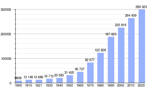 |
Population of censuses of the National Institute of Statistics and Geography (INEGI) from 1900 to 2020. |
Ethnic groups
The population over five years of age that speaks an indigenous language in the municipality of Uruapan amounts to a total of 16,043 people, which are 7,856 men and 8,197 women; Of these, 14,352 are bilingual in Spanish, only 1,394 speak only their mother tongue, and 297 do not specify their status. Most of the speakers of an indigenous language in Uruapan are Purepecha, totaling 15,127 speakers, Mazahua with only 37 speakers, Nahuatl with 35, 14 speakers of Mixtec languages, 7 of Otomi, 4 of Zapotec languages, 3 of Maya, and between three and one speaker of languages such as Amuzgo, Huichol, Tarahumara, Tlapaneco, Totonac, Tsotsil and Tseltal.
Neighborhoods

History tells us that since pre-Hispanic times the region was inhabited by a complex Purépecha society, whose center was Tzintzuntzan (place of hummingbirds). When the conquistadors arrived, the ancient inhabitants were persecuted, murdered, looted, and their mythologies offended. In this way, the indigenous people fled to the mountains to protect themselves from the invaders. In this context, Fray Juan de San Miguel arrived in 1533, a Spanish Franciscan friar who carried out a great work of mediation, evangelization and pacification. Over time he convinced them to return to their regions, organized them into communities and assigned a Patron Saint to each one. This is how the nine neighborhoods of Uruapan were founded:
- The Magdalena
- San Miguel
- San Pedro
- San Juan Evangelista
- St. John the Baptist
- The Three Kings
- The Most Holy Trinity
- San Francisco
- Santo Santiago
Each neighborhood was governed by a government called the República de Indios which over time became a true parallel power to the Spanish Government. The representative of the Republic was elected every year in assembly. This institution disappeared in 1767 when the Spanish crown punished them for the continuous protest riots against the monarchy. On the other hand, the religious organization was deposited in four "Cargueros", in Indians "Semaneros" and in a "Butler". In each of the neighborhoods, a chapel was built in which an altarpiece was built with the image of the Holy Title.

In the XXI century, the nine original neighborhoods were recovered, the case of the Barrio de La Santísima Trinidad whose The chapel was abandoned at the beginning of the 20th century and finally demolished in 1936 to become the headquarters of the Mexican Army, which caused the transfer of the characteristic symbols to the new neighborhood of the Sacred Heart of Jesus or El Vergel, located a few streets to the south. While that of San Juan Evangelista was forgotten as its chapel burned down in 1920, which led to the construction of a provisional one that would later be a church dedicated to La Sagrada Familia, leaving the original colony in oblivion, it was not until 2007 when it was recovered. the name of traditional neighborhood, locating its chapel inside the Municipal Pantheon, located in the same area. With the resurgence of the Sagrado Corazón and San Juan Evangelista neighborhoods, the only one considered lost was Los Tres Reyes, without However, at the beginning of the XXI century, this neighborhood identity was resumed, although under the name of San José, with a chapel located to the northeast of the city where the symbols of the original neighborhood were housed, so Uruapan returned to its nine original neighborhoods.
Economy

The economically active population of the municipality in 2005 was 33.1% and unemployment was 1.27%, people work mainly in the tertiary sector (commerce and services), with 82.7% of the total in 2005, followed by the secondary sector with 84.56%. The average income of the municipality in HIGH wages is 7.9.
- The main agricultural activity of the municipality of Uruapan is undoubtedly the cultivation of avocado, which has been called the green gold of Michoacán. The great boom in the production of avocado in the state was given from 1997, this was the year where the ban of exporting Mexican avocado to the United States decree imposed since 1913.2016 Since 1997 2016 the municipality has exported avocado to the United States being this the largest consumer of the Uruguayan production reaching 200 thousand tons of a total of 300 thousand tons exported abroad.
- Undoubtedly, some of the agricultural activities in the municipality are: the cultivation of sugar cane, corn, peach, coffee, guava and vegetables such as tomato, chili and pumpkin. Pecuary activity is important, in addition, bovine, pork, goat, equine, poultry and there is a small sector of forestry.
- Industrial activity is not very developed, although there are companies dedicated to the manufacture of plastics, paper manufacturing, chocolate-based products and avocado packaging.
- The trade and services sector is integrated by the activity of hotels and restaurants in the city, as well as of the shopping centres, including large international and national chains.
Tourism


The city has cultural and natural tourist attractions. Among the most prominent are:

- Lic National Park. Eduardo Ruiz: In which the river Cupatitzio (Río que canta) is born, minguar park in which it combines the crystal clear waters of the river, the lush vegetation and legends that are found when passing through each of the sources, the most relevant is that of "La knee del Diablo" just where the river is born.
- La Huatápera: It is an ancient hospital and one of the first in America, founded by Fray Juan de San Miguel, was a place where the indigenous were cured of their diseases, they were educated and instructed about religion. The materials with which it is built are: wood, tejamanil, volcanic stone and quarry. Its architectural style is Plateresco and Mudejar.
- The Tzararacua: south of Uruapan, downstream, 10 km along the road to New Italy, is located this extraordinary waterfall that has been and is a point of admiration of own and strange, surrounded by lush vegetation. You can reach her, enjoying a pleasant walk on foot or on horseback.
- Artisanal Tianguis Palm SundayThe center of the city is filled with handicrafts, all these are brought from different communities in which Fray Juan de San Miguel, where he evangelized the settlers and offered a trade.
- Temple of San Francisco and House of Culture: their origins date back to the foundation of the city, they are of silver style and were recently restored.
- Antojitos Market: typical dishes of the region can be found in that market.
- Factory of San Pedro: during the last century were made of high quality looms, now functioned as a convention center and in the same way a disco.
 Uruapan craving market.
 - Square of the Martyrs: it is located in the center of the city, in it is a monument erected in 1893 to honor the Martyrs of Uruapan, next to this square is the Plaza Morelos, where there is a monument dedicated to José María Morelos, who before joining the cause of independence, carried out his work as a priest in the city.
- The narrowest house in the world: which has lately become popular for appearing in the Guinness book of records. The house measures 1.4 × 7.7 m.

Uruapan is the starting point to get to know the Purhépecha plateau, and it is the step of the Don Vasco tourist route.
- Artisan Tianguis of Palm Sunday: Craftsmen meet from various points of the state, in particular members of the Nahua, Mazahua, Purépecha, and Otomi ethnic groups. Artisanal pieces are displayed and marketed, mainly made of mud, ceramic, wood, skin, copper, vegetable fibres, etc.
- Sail Festival (Night of the Dead): from October 29th on November 1st, on more than 20 thousand candles through the streets and squares of the center, night tours through the national park and the linear park "the cameline" on the shore of the Copaatitzio river.
Communications
Aerial
The municipality of Uruapan has the Uruapan International Airport, located within the urban sprawl. This air terminal has flights to the cities of Tijuana and Los Angeles operated by the airline Volaris, in addition to serving as an air communications point in the region.
Roads
- Federal Highway 37: It is a road that starts from the city of León, Guanajuato, crossing the state of Michoacán, in cities like La Piedad, it is at its turn through Uruapan it becomes the Paseo Lázaro Cárdenas, divides the city into two parts and follows its way to the coast until reaching the community of Playa Azul in the municipality of Lázaro Cárdenas
- Federal Highway 14: There is a free road and a highway of quota, which have a parallel layout, starting in the city of Pátzcuaro to Uruapan
- Autopista Siglo XXI: It is a highway that communicates to the cities of UruapanMorelia and Lazarus Cárdenas
- Uruapan-Los Reyes Road: It begins its route in the Federal Highway 37, about ten kilometres north of Uruapan, connects with the city of Los Reyes de Salgado, as well as being used as a communicative axis between different communities of the Purépecha Meseta and the western region of Michoacán.
- Uruapan-Tancitaro Road: Communicate the city of Uruapan with the municipalities of Nuevo San Juan Parangaricutiro and Tancítaro
Uruapan also has the Uruapan Bus Station, which offers bus services to different cities in the state of Michoacán and Mexico.

Railways
The city has a connection to the Mexico City-Acámbaro-Morelia-Uruapan railway, the current railway station is located in the community of Caltzontzin, and is used for cargo service.
Radio Broadcasters
In the city of Uruapan and its surroundings there are a total of 11 radio stations: 8 in Frequency Modulation and 4 in Amplitude Modulation, however, three of the AM frequencies also broadcast in FM.
Amplitude Modulation (AM)
| Name | Acronyms | Frequency |
| Stereo Mia | XEUF | 610 A.M. |
| Media Group Radio | XEUORN | 750 A.M. |
| The Mighty One | XEIP | 1050 A.M. |
| Candela Uruapan | XEFN | 1130 A.M. |
Frequency Modulation (FM)
| Name | Acronyms | Frequency |
| The Mighty One | XHIP | 89.7 F.M. |
| Candela Uruapan | XHFN | 91.1 F.M. |
| The 40s. | XHENI | 93.7 F.M. |
| SM Radio | XHRUA | 99.7 F.M. |
| Stereo Mia | XHUF | 100.5 F.M. |
| Stereo Youth Channel | XHIW | 101.3 F.M. |
| La Mexicana | XHURM | 102.1 F.M. |
| Uandarhi | XHRHI | 107.9 F.M. |
Open television
In the city of Uruapan you can tune in to 19 open television channels. However, it should be mentioned that several of the signals come from broadcast antennas located in other parts of Michoacán and are not assigned to this location.
| Acronyms | HD | TDT | Name | Owner |
|---|---|---|---|---|
| XHCBM | 1.1 1.2 | 24 | Aztec One Aztec 7 | TV Azteca |
| XHURT | 2.1 2.2 | 30 | The Stars ForumTV | Televisa |
| XHCTUR | 3.1 3.4 | 36 | Image Excélsior TV | Picture |
| XHMOW | 5.1 9.1 | 29 | Channel 5 NU9VE | Televisa |
| XHRAM | 7.1 7.2 | 23 | Aztec 7 a+ | TV Azteca |
| XHJGMI | 12.1 | 15 | Multimediated Michoacán | José Guadalupe Manuel Trejo García |
| XHBG | 13.1 | 27 | Canal 13 Michoacán | Telsusa Television Mexico, S.A. de C.V. |
| XHSPRUM | 14.1 14.2 11.1 20.1 22.1 45.1 | 14 | Canal Catorce Ingenio Tv 11 tv•unam Canal 22 Congress channel | Mexican State Public Broadcasting System |
| XHURU | 16.1 | 34 | SM Television | Government of the State of Michoacán |
Education
The schooling of the municipality is 7.8 years, the percentage of illiteracy is 9.1, however the municipality of Uruapan has covered the needs of basic, upper secondary and higher education.
Infrastructure and services
Health services
In Uruapan there are public and private medical institutions, in the first case there are two clinics and a hospital belonging to the IMSS, one from the ISSSTE, a Regional Hospital and a Health Center, which provide services to the municipality and others belonging to the region.
In the private sphere there are different hospitals and clinics such as the Fray Juan de San Miguel Hospital, El Ángel Hospital, Uruapan Civil Hospital, San Francisco Specialty Hospital, San Jorge Clinic, La Esperanza Clinic, La Magdalena Clinic or Red Cross Medical Services.
Commercial and entertainment establishments
Shopping centers
In the city there are various shopping centers which have different establishments, especially supermarkets, business service centers, food stores or clothing stores.
Sports infrastructure
In Uruapan there are two sports units, as well as some private clubs and other similar facilities
Sports units
- Hermanos López Rayón
- The Capulin
Political organization
The municipal government is made up of the municipal president, a trustee and the council made up of 12 councilors, 7 elected by relative majority and 5 by the principle of proportional representation. The city council is elected for a period of three years, renewable for the immediate period, beginning to exercise its position on September 1 of the year in which the election is held.
The municipality is divided for its internal administration into nine tenure headquarters, and into forty-six heads of order, all of them are elected by popular plebiscite and last three years in office.
State and Federal legislative representation
For the election of local deputies to the Michoacán Congress and federal deputies to the Chamber of Deputies, the municipality of Uruapan belongs to the following electoral districts:
Place:
- XIV Local Electoral District of Michoacán, Uruapan Norte.
- XX Local Electoral District of Michoacán, Uruapan Sur.
Federal:
- IX Federal Electoral District of Michoacán with head office in Uruapan.
Uruapan Municipal Presidents
Last periods:
- 1987-1989 Víctor Manuel Barragán Garibay

- 1989 Manuel Trejo
- 1990 Anacleto Mendoza
- 1990-1992 Agustín Martínez Maldonado
- 1993-1995 José Robledo Estrada
- 1996-1998 Jesús María Doddoli Murguía

- 1999-2001 Juan Rafael Elvira Quesada
- 2002-2004 Jesus Mary Doddoli Murguía
- 2004 Prisciliano Jiménez
- 2005-2007 Marco Antonio Lagunas Vázquez

- 2008-2009 Antonio González Rodríguez
- 2009-2010 Jesús María Doddoli Murguía
- 2010-2011 Antonio González Rodríguez
- 2012-2015 Aldo Macias Alejandres

- 2015-2018 Víctor Manuel Manríquez González

- 2018-2020 Víctor Manuel Manríquez González
- 2020-2021 Michelangelo Paredes Melgoza
- 2021-2021 Luis Manuel Magaña
- 2021 Ignacio Benjamín Campos Equihua


Holdings
The Municipality of Uruapan has the following tenures:
- Capacuaro
- Angahuan
Angahuan is a Michhuaque or P'urhépecha community, located 32 kilometers from the city of Uruapan in the state of Michoacán. It is a community of pre-Hispanic origin that still preserves its language, its customs and traditions; They speak the Michhuaque or P'urhépecha language. It is a very visited tourist place due to its proximity to the Paríkutini volcano, Paricutin and the pre-Hispanic town of Paranharikutiro, San Juan Parangaricutiro, which was buried by the volcano in 1943. It has a tourist area with very good services, such as: as a hotel and cabins, parking, sale of handicrafts, horseback riding services to the volcano and to the ruins of the Church of Parangaricutiro, buried by the volcano among other things.
Angahuuan (Angahuan), place name michhuaque which means, where is the temple of the god prince, where is the temple of the son of the Lord. Formed by anga-, radical of angahchacuhpeni, to be a prince or leader of people (Dic. Gde. Tar-Esp, p. 32); huua-, radical of huuata, mount, hill (Dic. Gde. Esp-Tar, p. 500), by extension place; and, an- radical of angaxurini, to be standing (Gilberti, Vocab. Tar-Cast, fo. 6v); or, the radical of anga, to be upright (in the temple), upright thing (Lagunas, Dec. Fo. 18), by extension where the temple of a deity is raised; the same evangelizer affirms that place names "that derive from the names of idols or barbarically" (Lagunas, Arte fo. 152), that is, from the names of the gods; thus forming the preterm Anga-huua-an, in which the radical huua-, upon joining with the ending -an, loses the final letter a to avoid duplication. (Morphological research by Salvador Garibay Sotelo) The prince god is a Michhuaque deity, equivalent to Piltzintecuhtli (Nahuatl language), the child god, from Aztec or Mexican mythology.
- San Lorenzo
- Caltzontzin
- Jucutacato
- Jicalán
- Santa Ana Zirosto
- Corupo
- New Zirosto
Sports
In Mexican soccer, the city of Uruapan is represented by the Aguacateros CDU team, which was founded in July 2018 and participates in the Second Division of Mexico, third category of the professional league system of the Mexican Soccer Federation. Previously, the town had two teams: Club Deportivo Uruapan and the Originales Aguacateros de Uruapan, which merged to form the current club.
On the other hand, the Ireris Uruapan team, which participates in the Mexican Women's Volleyball League, also has its headquarters in the town.
Sister cities
The city of Uruapan is twinned with the following cities:
 Culver City, United States; since February 24, 1964.
 Matanzas, Cuba; since 10 October 2003.
- North Little Rock, United States; from September 30, 2005.
 Quillota, Chile; From December 10, 2005
 Antigua Guatemala, Guatemala, since 23 July 2003.
 Madrigal de las Altas Torres, Spain; since 14 March 2007.
- Kansas City, United States; since October 23, 2008.
 Casma, Peru, since 24 August 2012.
 Zihuatanejo, Mexico; from 1 June 2013.
- Bacanora, Mexico; since 26 November 2016.
- Laredo, United States; since 12 November 2021.
Contenido relacionado
Cyperez
Castraz
Counties of England