
Ural River
The Ural (Russian: Урал, Ural; Kazakh: Жайық, Zhayyq ) is a river in the extreme east of Europe and the extreme west of Asia, which originates in the south of the Ural Mountains and flows in a south-west-south direction through Russia and Kazakhstan, until it empties into the sea. Caspian. Traditionally it is considered the border between Europe and Asia. With 2,228 kilometers in length, it is the third longest in Europe, after the Volga and the Danube, and drains a basin of 231,000 km².
Administratively, it runs through the Orenburg Oblast, the Chelyabinsk Oblast and the Autonomous Republic of Bashkortostan, in the Russian Federation; and for the Atyrau oblis, in Kazakhstan.
Etymology
The river, at the beginning of the reign of Catherine II during the 18th century, was called Yaík (Russian: Яик). After the end of the Cossack rebellion, in the vast region of the river, the empress decided to change the name to Ural (in Russian: Урал), probably trying to erase the memory of the aforementioned event.
The current name in Kazakh, Zhayyq (Жайық), is the direct equivalent for the ancient Yaík.
Geography
The Ural River rises in the southeastern part of the Ural Mountains, near the city of Uchaly, about 150 km from the city of Magnitogorsk, in the northeastern border of Bashkortostan. The river heads south through the eastern region of the Ural foothills, in a section where it forms some lakes and, after passing through the city of Oral, it enters the Chelyabinsk Oblast. In this first section, the river runs parallel to another important channel, the Bélaya River, a few kilometers further west. It continues in a southerly direction, in a section where the Verjneurálskoye reservoir has been built, after which the river passes through the important industrial city of Magnitogorsk. Downstream, it receives its first important tributaries: on the left, the Guzbeika and Zingueika rivers; and, on the right, the Yanguelka and the Bolshoi Kizil. It then crosses the towns of Kazílskoye and Bogdanovskoye, receives the Bolshoi Karaganka on the left and enters the Orenburg Oblast.
It continues to flow south, in a section where the tail of the long Iriklínskoye reservoir is located, more than 60 km in length, and in which it receives the waters of the Sunduk rivers, on the left, and Tanalyk, on the right. It crosses the towns of Iriklínskoye and Kolpaskoye and, after receiving the waters of the Bolshoi Kumak River on the left, it reaches another important city, a former agricultural commercial center that is today an important industrial city: Orsk (250,963 inhabitants in 2002).
Here the water current decisively turns its course ninety degrees, heading west, and a few kilometers away it bathes another important nearby industrial city, Novotroitsk. The river flows in the same westward direction for a long stretch of more than 300 km south of the southern Urals, crossing a weakly occupied steppe region in the that there are no settlements of importance until Orenburg. After Novotroitsk, the river forms the natural border between Russia and Kazakhstan for more than 70 km, a section in which it receives the waters of the Guberlia River from the right. Then it continues in the same direction, parallel to the south to the P-360 highway between Orenburg and Orsk, a section in which it receives the waters on the left of many streams that have their sources in Kazakh territory: Kizhalý Burtá, Urlá-Burtzhia, Burtzhia and Berdianka. Finally, it reaches Orenburg, the capital of the homonymous oblast and the main city of its entire course. It continues to flow towards the west and soon receives the waters of one of its longest tributaries, the Sakmara River, on the right; Then, for a short distance, the stream borders the Obshchi Syrt mountain range, a branch of the Ural Mountains. In this section, on the left, it receives other Kazakh rivers, such as the Dongüi, the Chiórnaya and the longer Ilek River, which marks the beginning of another section of about 80 km, which begins after the town of Ilek, in the that the river will be the natural border between Russia and Kazakhstan. In this border section it receives the Kindelia River on the right and the Utva River on the left. After the Russian town of Rannoye, where it receives the Buzuluk River on the right, the Ural River enters the territory of Kazakhstan, where it is called "Oral".
The watercourse runs through a very flat and arid region, in an increasingly meandering course, with many long meanders, in a section that takes it to the city of Oral (Uralsk in Russian). There, after receiving the waters from Russia from the Chagan River on the right, it turns south. In this last part of its course, it runs in a flat region covered by a thin steppe that gradually first becomes semi-desert and later, as it approaches the Caspian Sea, it becomes increasingly humid. In this section it bathes the towns of Chapáyevo, Inderborski and Atyrau.
After a long journey of 2,428 kilometers, many of them conventionally considered the border between Europe and Asia, it finally flows into the Caspian Sea in the form of a delta.
The fishing industry has developed along the river.
Riverside cities
The areas affected by the river basin have a low population density, particularly in the areas of Kazakh territory, due to the arid climate and subject to a range of extreme temperatures throughout the year. The population is mostly concentrated in large cities, the most important being the following:
- Magnitogorsk, with 418 545 inhabitants in 2002.
- Orsk, with 250 963 inhabitants in 2002 (Orembourg population);
- Orembourg, with 549 361 inhabitants in 2002 (Orthenburg population);
- Novotroitsk, 106 315 inhabitants in 2002 (Orthenburg population);
- Oral, with 210 600 estimated inhabitants in 2007 (Kazajistan);
- Atyrau, with 154 100 estimated inhabitants in 2007 (Kazajistan);
Maps and images

Map in Russian of the Ural River, in which the cities of Verjneuralsk (Верхнеральск), Magnitogorsk (Máгнитогорск), Orsk (Орск), Novotroitsk (Новотроицк), Orembourg (Оренарг), Oral (рарарарарарарарарарарарарарарарарарарарьк)

Mismo map in English

Aerial view of the course of the Ural River, between Oral and Atyrau (Kazajistan)

Bridge crossing the river in Orembourg

Night view of a bridge over the Ural River (Orembourg)


Tributaries
The Ural River, despite its length, drains an area of approximately 231,000 km², much smaller than the territory covered by the basins of the main rivers of Russia, which means that it does not have tributaries with significant basins. The most important of its tributaries are the Sakmará River, on the right, and the Or and Ilek Rivers, on the left. One of the reasons for the reduction in the size of the basin is the dryness of the climate, which causes some rivers (such as the Uil, the Olenty or the Kaldygajty) to have become endorheic basins in places close to the course of the Ural River.
The main tributaries of the Ural River are the following (ordered from source to mouth):
- Sunduk River;
- river Tanalyk (Tyrall), on the right, with a length of 225 km, a basin of 4160 km2 and a flow of 2.96 m3/s;
- River Gran Kizil (Bolíssip), with a length of 172 km, a basin of 2080 km2;
- river Or (Орь), with a length of 332 km, a basin of 18 600 km2 and a flow of 21.3 m3/s;
- river Guberlia (Gááерля), with a length of 110 km, a basin of 18 600 km2 and a flow of 6.3 m3/s;
- River Salmys;
- river Sakmara (Сакмара), with a length of 798 km, a basin of 30 200 km2 and a flow of 144 m3/s; in turn, it has as a subfluent to the Bolshói Ik River (Bioльшой Íк), with a length of 341 km, a basin of 7670 km2 and a flow of 61 m3/s;
- Kindelia River;
- River Bolshaya Chobda;
- river Ilek (Ilek), with a length of 623 km, a basin of 41 300 km2 and a flow of 39.8 m3/s;
- River Utva;
- Irtek river;
- Chagán River, with a length of 264 km, a basin of 7350 km2 and a flow of 7.7 m3/s;
Fluvial regime
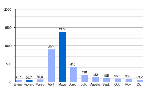
The Ural does not have a high water flow, despite the size of its basin, since it passes through very arid climatic zones. Like most Russian rivers, the minimum is reached at the end of the winter season, which runs from the beginning of November to the beginning of April, in the upper course, and, from the end of November to the end of March, in the lower course.. Peak flooding occurs in spring, a season in which the Ural discharges approximately 80% of its annual flow.
It presents a moderate plain snow regime. In fact, there is a sudden rise in the level of the river's waters in April and May, when the snow melts. Then, the flow and water level decrease considerably, reaching their lowest levels in February. Its average flow is more than 55.7 m³/s, compared to 1,377 m³/s in May.
The average annual flow is around 100 m³/s in the city of Orenburg, in the middle course, and rises in Kusum, in the lower course, to almost 400 m³/s. These values can reach, at the same points, a maximum of 12,000 and 14,000 m³/s and a minimum of 1.6 and 13.3 m³/s.
| Average monthly flow of the Ural River at Kusum hydrological station (Data calculated in the period 2000-23, with a green basin of 190 000 km2, in m3/s) |
 |
Fauna
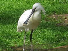
The wetlands of the Ural River Delta and its surroundings are especially important for migratory birds, as they constitute an important stopover on the Asian migratory route. They are home to many endemic and endangered species, such as the common pelican, the crested pelican, pygmy cormorant, cattle egret, little egret, flamingo, white-headed duck, brown pochard, spoonbill, brown ibis, houbara bustard, black-headed gull, slender-billed gull, crab egret, common crane, damselfish crane, curlew slender-billed stork, red-breasted stork, lesser black-faced goose, lesser kestrel, whooper swan, tundra swan, osprey, hen harrier, short-toed eagle and many others. The pygmy cormorant was observed sporadically before 1999 and more regularly thereafter. The cattle egret has been observed since 1990 between April and September (like most other migratory birds in this area), with a total population of several dozen pairs. It feeds on frogs, mollusks and small fish. Upstream, there are more resident bird species, such as capercaillie, wild pigeon and partridge.
The Ural River is also important for many species of fish from the Caspian Sea that visit its delta and migrate upstream to spawn. In the lower course of the river there are 47 species from 13 families. The Cyprinidae family represents 40%, sturgeon and herring 11%, perch and herring 9% and salmon 4.4%. The main commercial species are sturgeon, roach, bream, perch, carp, asp and European catfish. Rare species include Caspian salmon, sterlet sturgeon, white salmon and kutum.
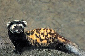
About 48 animal species belonging to 7 orders live in the river delta and nearby regions; the most common are rodents (21 species) and predators (12). Among them, the bat Eptesicus bobrinskoi and the marbled polecat are endemic. The key species are the raccoon dog, the muskrat (recently emerging), the European hare, the house mouse, the brown rat and the wild boar. Wild boars had a density of 1.2-2.5 per hectare in 2000 and are hunted commercially. Other animals include the elk, fox, wolf, fat-tailed dwarf gerbil, great gerbil, northern mole, and saiga antelope. The Turkmen kulan (Equus hemionus kulan) used to live on the Ural River. It is possible that it is extinct from that region.
Reptiles are represented by the swamp turtle, common water snake, rat snake and sand lizard. Swamp turtles are found in all waters. Common water snakes live on the banks of canals. Rat snakes and sand lizards are rare and live on relatively high land areas. Two other reptiles, the Caspian whip snake and Coluber spinalis, are extremely rare. Among amphibians, the lake frog and the green frog are common.
With some 5,000 to 10,000 species, insects surpass all other animals in the region in diversity and biomass. Terrestrial and aquatic insects make up a significant proportion of the birds' diet. Many species are parasitic on birds and transmit infections. Other dominant inhabitants of the river are protozoans, rotifers, cladocerans and copepods. Mollusks are mainly represented by gastropods and bivalves.
Euro-Asian State

Estobius talpinus North mole

Great rank
Bulgarian tube

Sturdy


History

Between the 10th and 16th centuries, the city of Saray-Jük (or Saraichik, meaning 'little Sarai'), on the banks of the Ural River (now in the Kazakh province of Atyrau), was a important commercial center of the Silk Road. In the 13th century, it became a stronghold of the Golden Horde. It was destroyed in 1395 by Timur's army, but was later rebuilt to become the capital of the Nogai Horde in the 15th and 16th centuries. It was eventually reduced to a village in 1580 by the Ural Cossacks.
After the Russian conquest of the Ural basin at the end of the XVI century, the banks of the Urals became in the home of the Yaik Cossacks. One of its main activities was fishing for sturgeon and related fish (including true sturgeon, starry sturgeon and beluga) in the Ural and Caspian Rivers. There was a great variety of fishing techniques; the most famous of them was the bagrenye (in Russian: багренье, from bagor in Russian: багор, meaning pike rod): harpoon hibernating sturgeons in their underwater lairs in the middle of winter. Bagrenye was only allowed one day a year. On the appointed day, a large number of Cossacks with pike poles were gathering on the shore; After giving a signal, they rushed onto the ice, broke it with their poles, and speared and fished out the fish. Another fishing technique consisted of building a weir, known as uchug (учуг) on the other side of the river, to capture fish that came upstream to spawn. Until 1918, a uchug was installed in summer and autumn near Uralsk, so that the fish did not go up the river beyond the Cossack lands. Although uchug reservoirs were also known in the Volga delta, bagrenye was thought to be a technique unique to the Urals.
The Ural Cossacks (originally known as Yaik Cossacks) resented the central government's attempts to impose rules and regulations on them, and at times revolted. The largest rebellion, the Pugachev Rebellion of 1773-75, affected not only the Urals, but much of southeastern Russia, and saw the loss of government control in the area. After its suppression, Empress Catherine promulgated a decree of January 15, 1775 to change the name of most of the places involved in the revolt, in order to erase the memory of it. Thus, the Yaik River and the city of Yaitsk were renamed the Ural River and Uralsk, respectively, and the Yaik Cossacks became the Ural Cossacks.
Contenido relacionado
Okayama Prefecture
Annex: Municipalities of the province of Zamora
Veracruz (disambiguation)