
Tropic of Capricorn

The Tropic of Capricorn is a parallel to the southern hemisphere. It is situated at a latitude of 23° 26' 17", south of the equator. This imaginary line delimits the most southern points in which the Sun can occupy the zenith at noon. In the Tropic of Capricorn, therefore, the sun's rays fall vertically on the ground at the instant the December solstice occurs, which occurs between December 21 and 22, date and time given in astronomical tables in time Coordinated Universal Time (UTC). The Tropic of Capricorn marks the southern limit of the so-called intertropical zone, between the Tropics of Capricorn and Cancer. It is called "of Capricorn" because in classical antiquity, when the summer solstice occurred in the southern hemisphere, the Sun was in the constellation of Capricorn. Currently, it is in the constellation of Sagittarius, but the name Tropic of Capricorn continues to be accepted by tradition.
Origin of name
The name Tropic of Capricorn is astrological because the date of the month/astrological sign of the astrological year that coincides with the summer solstice in the southern hemisphere is the 1st of the month/sign of Capricorn (10th month of the astrological year)., and in the Gregorian calendar the corresponding day is December 22. Astrologers date the days of the astrological calendar in Gregorian format; hence the beginning of the sign/month of Capricorn is dated as December 22, and the tropic is called "of Capricorn". However, the solstice is an astronomical phenomenon and has its astronomical name, as well as the tropics. In fact, on that same solstice the Sun appears visually at the beginning of the constellation Sagittarius in the annual sense and at the end in the sense of precession (1 degree every 71 years = 1 precessional day), and thus we can identify it with an astronomical name.: «solstice of Sagittarius», and also to the tropic as «tropic of Sagittarius». Also, since the solstice is intimately linked to precession, there are still a few hundred years left for the day of the December solstice for the Sun to appear in the zodiacal constellation, prior to Sagittarius, which is Ophiuchus, and to be the solstice and tropic of Ophiuchus». And likewise with the other solstice and the Tropic of Cancer.[citation needed]
Geography and environment
The Tropic of Capricorn is the dividing line between the South to the south and the tropics to the north. The Northern Hemisphere equivalent of the Tropic of Capricorn is the Tropic of Cancer.
The position of the Tropic of Capricorn is not fixed, but is constantly changing due to a slight wobble in the Earth's longitudinal alignment relative to its orbit around the Sun. The Earth's axial tilt varies over a period of 41,000 years from 22.1 to 24.5 degrees and currently stands at about 23.4 degrees. This wobble means that the Tropic of Capricorn is currently moving north at a rate of nearly half a second of arc (0.468″) latitude, or 15 meters, per year (it was exactly 23° 27′S in 1917 and will be at 23° 26'S in 2045). Therefore the distance between the Arctic Circle and the Tropic of Capricorn is essentially constant while moving in parallel. See under circles of latitude for information.
During the June solstice (southern hemisphere winter) there are approximately 10 hours and 41 minutes of light. During the December solstice (southern hemisphere summer), there are 13 hours, 35 minutes of daylight. The longitude of the Tropic of Capricorn at 23°26′11.7″S is 36,788 km (22,859 mi).
Africa
In most of this southern African belt, a seasonal rainfall minimum is reliable and agriculture is possible, though yields struggle to compete with, say, the Mississippi Basin, even against similar soil fertilizers. Rivers have been successfully dammed, especially those flowing from high-relief rainfall areas (high eminences) and those coming from the edge of the Great Rift Valley, such as the Zambezi, deep within the Tropics. This, with alluvial or enriched soils, allows for the cultivation of cereals of considerable yield in areas with good soil. Pasture farming is widespread throughout this vast region, which, when intensive, brief, and rotating, helps fertilize and stabilize the soil, preventing runoff and desertification. This approach is traditional in many tribes and is promoted by advisors. such as Allan Savory, Zimbabwean-born biologist, farmer, game herder, politician and international consultant and co-founder of the Savory Institute. According to the United Nations University Our World, he is credited with developing "holistic management" in the 1960s and has for decades led anti-desertification efforts in Africa, using an approach contrary to most developed economies of increasing the number of cattle on rangelands rather than fencing them for conservation. Such practices in this area have been successful and have won generous awards; he delivered the keynote address at the UNCCD Earth Day in 2018, and later that year in a widely broadcast TED conference address.

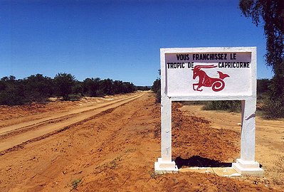
A sign that marks the Tropic of Capricorn in its passage through Namibia.

A monument that marks the Tropic of Capricorn at its passage through Botswana.
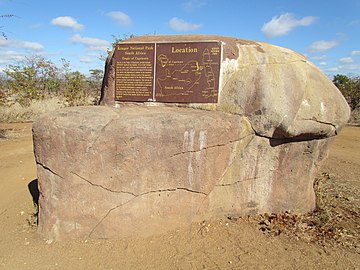
A monument in Kruger National Park, South Africa.
A sign that marks the Tropic of Capricorn in Atsimo-Andrefana Region, Madagascar.
.jpg)


Australia
In Australia, areas around the Tropics have some of the most variable rainfall in the world. In the east, advanced plants such as flowering shrubs and eucalypts, and in most bioregions, grasses grow They have adapted to deal with environments such as deep roots and low transpiration. In the more humid areas, irrigated seasonally, grazing is practiced a lot. As for animals, birds and marsupials are well adapted. The arable, naturally difficult, specializes in dry fruits, nuts and products with modest water consumption. Other types are possible if reliable irrigation sources are available and, in the best of cases, enriched or alluvial soils that retain water, especially wheat; shallow irrigation sources dry up very often in and after dry years. The Great Dividing Range provides sufficient rainfall in relief to make cultivable hundreds of kilometers on both sides, and its rivers are extensively dammed to store the necessary water; this benefits populated areas of New South Wales and Queensland.
Beyond the end of the green hills, far from the Pacific, which is subject to warm and negative El Niño-Southern Oscillation phases (colloquially this is an "El Niño year/season"), lies a white, red and yellow landscape of 2,800 to 3,300 kilometers of rain shadow heading west, which, in turn, presents the normally arid cattle lands of Channel Country, the white Kati Thanda- Lake Eyre National Park, the mainly red Mamungari Conservation Park, then the Gibson Desert, after others the dry landscape settlement of Kalbarri on the west coast and the rest to the north. The Channel Country presents an arid landscape with a series of former floodplains of rivers that only flow intermittently. The major rivers are the Georgina River, Cooper Creek, and the Diamantina River. In most years their waters are absorbed into the land or evaporate, but when there is sufficient rainfall in their catchment area these rivers flow into Lake Eyre in South Australia. One of the most important rainfall events occurred in 2010, when a low monsoon from former Cyclone Olga created a period of exceptional rainfall.
Adverse phases of El Niño cause a change in atmospheric circulation; precipitation decreases over Indonesia and Australia, rainfall and tropical cyclone formation increase over the tropical Pacific. Low-level surface trade winds, which normally blow east-west along the equator, weaken or begin to blow from the other direction.

Tropic of Capricorn at its pass through Australia in the Dunn World Map of 1794

Road sign marking the Capricorn Tropic in Western Australia

Monument marking the Capricorn Tropic north of Alice Springs, Northern Territory

Capricorn Tropic at Diamantina Developmental Road, Amaroo, Queensland

Needle Marking Capricorn Tropic in Rockhampton, Queensland


South America
In South America, while soils in the continental craton are almost as old as in Australia and southern Africa, the presence of the geologically young and evolving Andes places this region on the opposite side. west of subtropical anticyclones and therefore receives warm, humid air from the Atlantic Ocean. As a result, the parts of Brazil adjacent to the Tropics are impressively productive agricultural regions, producing vast amounts of crops such as sugar cane, and the natural vegetation of the tropical rainforest has been almost entirely cleared, except for a few patches. remaining Atlantic Forest. Further south in Argentina, the temperate grasslands of the Pampas region are equally influential in wheat, soybeans, corn and beef, making the country one of the world's largest agricultural exporters, similar to the role played by the prairie region in Canada.
West of the Andes, which creates a rain shadow, the air is further cooled and dried by the cold Humboldt Current, making it very arid, creating the Atacama Desert, one of the driest in the world. world, so there are no glaciers between Volcán Sajama at 18˚30'S and Cerro Tres Cruces at 27˚S. Vegetation here is almost nonexistent, although on the eastern slopes of the Andes rainfall is adequate for rainfed agriculture.
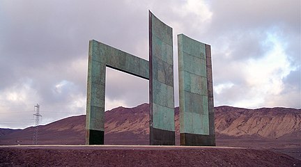
Monument marking the Tropic of Capricorn north of Antofagasta, Chile

Capricorn Tropic Solar Clock, Jujuy Province, Argentina

Signal that marks the tropics in Maringá, Brazil

Sign that marks the tropics in Maringá, Paraná, Brazil
.jpg)


Countries traversed
 Argentina
 Australia
 Botswana
 Brazil
 Chile
Chile Madagascar
 Mozambique
 Namibia
 Paraguay
 South Africa
- Template:Geodatos Adriano
 Peru
Peru
Countries that are completely below
As most of the land area is in the Northern Hemisphere, only four countries are completely south of the Tropic of Capricorn (as opposed to 73, about a third of today's total, completely north of the Tropic of Cancer):
 Lesoto
 New Zealand
 Swaziland
 Uruguay
Gallery
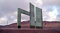
Hito the Tropic of Capricorn. Region of Antofagasta, Chile

Solar clock of the Tropic of Capricorn, near the town of Huacalera, Jujuy Province, Argentina.

Tropic Monolith of Capricorn. To the bottom, solar clock. Near Huacalera, Jujuy, Argentina

Capricorn Tropic Framework in Itaí, São Paulo, Brazil.

Toliara Province, Madagascar.

_REFON.jpg)
Contenido relacionado
Bulnes orange tree
Space Shuttle Naming Designation
Territorial Organization of Cuba