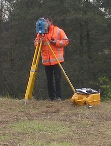
Total station
A total station is an electro-optical device used in surveying, whose operation is supported by electronic technology. It consists of the incorporation of a distance meter and a microprocessor to an electronic theodolite.
Some of the features that it incorporates, and which theodolites do not have, are an alphanumeric liquid crystal display (LCD), warning leds, lighting independent of sunlight, calculator, distance meter, tracker (path follower) and in electronic format, which allows it to be used later on personal computers. They come equipped with various simple programs that allow, among other capabilities, the calculation of coordinates in the field, setting out points in a simple and efficient way, and calculation of azimuths and distances.
Operation
Viewed like a theodolite, a total station is made up of the same parts and functions. The parking and verticalization are identical, although for the total station there are electronic levels that facilitate the task. The three axes and their associated errors are also present: the verticality one, which with the double compensation sees its influence on the horizontal readings reduced, and the collimation and inclination of the secondary axis, with the same behavior as in a classic theodolite, except that the first can be corrected by software, while in the second the correction must be done by mechanical methods.
The instrument performs angle measurement from marks made on transparent discs. The distance readings are carried out by means of a carrier electromagnetic wave (generally microwaves or infrared) with different frequencies that bounces off a prism located at the point to be measured and returns, taking the instrument the phase difference between the waves. Some total stations feature the ability to measure "to solid," which means that a reflective prism is not necessary.
This instrument allows obtaining coordinates of points with respect to a local or arbitrary system, as well as defined and materialized systems. To obtain these coordinates, the instrument performs a series of readings and calculations on them and other data supplied by the operator. The readings obtained with this instrument are those of vertical and horizontal angles and distances. Another particularity of this instrument is the possibility of incorporating data such as point coordinates, codes, pressure and temperature corrections, etc.
The precision of the measurements is of the order of one ten thousandth of a gradian in angles and millimeters in distances, being able to make measurements at points located between 2 and 5 kilometers depending on the device and the number of prisms used. For the optimal performance of the total stations it is necessary that the equipment is calibrated; for this, maintenance and adjustments must be given through the use of a collimator.
Theodolite, total station and GPS
Generically, they are called total stations because they have the ability to measure angles, distances, and levels, which previously required various instruments. These electro-optical theodolites have long been an economically accessible technical reality. Their precision, ease of use and the possibility of storing the information to download it later in CAD programs have made them displace theodolites, which are currently out of use.
On the other hand, for several years now, total stations have been displaced by GNSS (Global Navigation Satellite System) equipment that includes systems such as GPS, formerly known as Navstar, from the USA. USA, GLONASS from Russia, COMPASS from China and GALILEO from the European Union. The advantages of the topographic GNSS with respect to the total station are that, once the ground base is established, only one person is necessary to collect the data, while the station required two: the technician who managed the station and the operator who positioned the prism; and although with robotic total station technology this is no longer necessary, the price of GNSS systems has fallen so much that they have been displacing those in the open field. On the other hand, the total station requires that there be a line of sight between the device and the prism (or control point), which is not necessary with GNSS, although GNSS for its part requires the operator to be located at said point, which which is not always possible. The great advantage that the total station maintains over satellite systems are indoor and underground jobs, in addition to those where the operator cannot access, such as electrical towers or cliffs, and that with non-prism measurement systems of up to 3000m (at the date) these surveys can be done by one person and from a single point, although laser scanners and LIDAR technology have been gaining ground in this regard.
Instrument makers
- F. W. Breithaupt & Sohn
- Fennel (Geo-Fennel)
- KOLIDA
- Hilti
- Leica Geosystems
- Topcon
- Trimble
- North Surveying
- Stonex
- Pentax
- Acnovo
- Nikon, (historically), is now part of Trimble Navigations Ltd.
- Ruide (historically), is now part of South Surveying and Mapping Instruments Co. Ltd.
- Kern & Co. AG (up to 1992, today Leica Geosystems)
- Wild Heerbrugg AG (historically). The company was absorbed by Leica Geosystems in 1990
- Miller, Innsbruck (until 1990)
- Sokkia (historically), is now part of Topcon.
- Carl Zeiss (historically), is now part of Trimble Navigations Ltd.
- Geodimeter (historically), is now part of Trimble Navigations Ltd.
- Spectra Precision, (historically), is now part of Trimble Navigations Ltd.
Contenido relacionado
The age of spirit machines
Patent
Coupled charge device

