
Toledo Province
Toledo is a Spanish province of the autonomous community of Castilla-La Mancha, with its capital in the homonymous city of Toledo. It has a population of 703,772 inhabitants (INE 2020), spread over 204 municipalities. The Tagus River, which passes through the cities of Toledo and Talavera de la Reina, crosses the province from east to west, opening a wide valley in its path, which leaves the Sierra de San Vicente to the north and the Montes de Toledo to the south. In the southeast of the province lies the Manchego plain. Toledo limits to the north with Ávila and Madrid, to the east with Cuenca, to the south with Ciudad Real, to the southwest with Badajoz and to the west with Cáceres.
Symbols
The coat of arms previously used by the Provincial Council was very similar to that of the capital, with the exception that it accompanies the imperial eagle of the Pillars of Hercules: Counter-quartered coat of arms of Castilla y León, set at the point of Granada. It is represented in a silver field, loaded on the Golden Fleece, attached to an eagle exploded with saber, chopped and limbed with gold, tongued and clawed gules and with an imperial crown at the bell, flanked by the Pillars of Hercules on waves of azure, also crowned with an imperial crown and the legend Plus Ultra.
On May 13, 2013, the Provincial Council updated its heraldic shield and its flag. The shield is emblazoned as follows:

Shield: Bicephalus eagle in sable, with shield left in two barracks, the first with a barracks of Castile and Leon and the second in azur with an imperial crown of gold. Tied with the imperial crown, crowned by the world and the cross; surrounding the shield appears the Golden Toy. On one side the columns of Hercules on two waves of sugar, also crowned with Imperial crown and the Legend Plus Ultra.Diario Oficial de Castilla-La Mancha No. 103 of 29 May 2013
The textual description of the flag is as follows:
Flag: green or simplified with the previous shield on the Flag.Diario Oficial de Castilla-La Mancha No. 103 of 29 May 2013
Geography
It borders with Madrid and with the provinces of Ávila (Castilla y León), Cáceres and Badajoz (Extremadura), apart from the Castilian-La Mancha provinces of Cuenca and Ciudad Real.

The northern limit of the province of Toledo begins at the confluence of the Alardos gorge with the Tiétar, and follows its course, passing to the south and north of the watercourse in some sections, until reaching the municipality of Fresnedilla; It then continues to the south of this locality and Higuera de las Dueñas, which are towards Ávila, and along the Cenicientos to the Alberche River, which crosses to the north of Méntrida, and goes between Navalcarnero and Casarrubios to cut the Guadarrama River, below Batres; It then passes through the north of Carranque, Ugena, and Seseña to look for the Jarama river, downstream from its union with the Tajuña; It then heads towards the Tagus, along whose right bank it continues to the south of Villamanrique, not far from this town; it turns east there and goes south of Zarza de Tajo to end at the Riánsares river, south of Tarancón.

The eastern limit follows the course of this river until its confluence with a stream that rises towards Rozalén: there it takes a southeasterly direction, crosses the Cigüela river and passes between Villamayor de Santiago and Villanueva de Alcardete, Mota del Cuervo and El Toboso, to the northwest of Pedro Muñoz.
From this point the southern limit starts, and passing through the north of Cristo de Villajos, Campo de Criptana and Alcázar de San Juan, it goes to look for the Cigüela downstream and to the south of the Quero lagoon. It follows the course of this river until the end of Herencia, passes through the north of said town, from the ventas of Puerto Lápice, origins of the Amarguillo and Valdespino streams, to Piedraescrita and Minas de Santa Quiteria and the meeting of the Guadarranque river.
The western limit continues up the course of this river to its source; it then passes between Aldeanueva de San Bartolomé and Carrascalejo, to the east of Villar del Pedroso as far as El Puente del Arzobispo; It then continues through the west of Valdeverdeja and La Calzada de Oropesa, to look for the Tiétar river at its confluence with the Alardos gorge.
From the territory enclosed in these limits, we must exclude the royal site of Aranjuez, which is part of the province of Madrid.
| Northwest: Avila | North: Madrid | Northeast: Madrid |
| West: Cáceres |  | This: Cuenca |
| Southwest: Badajoz | South: Ciudad Real | Sureste: Ciudad Real |
Provincial boundary

Orography
.jpg)
The 15,368 km² of the province of Toledo rise on a plain of about 590 m above sea level at average altitude. Being between 201 and 600 m. 6,285 km², between 601 to 1,000 m 8,620 km², and between 1,001 to 2,000 m 463 km². To the right of the Tagus, the slope is around 2/1000, with wide fields, gentle undulations, where rivers and streams with wide meadows descend, in contrast to the left bank, where the terrain rises rapidly, abrupt, it seems that a large mountainous area is going to extend towards the south, with rough streams, ravines and deep gorges, whose slope reaches 60/1000. When it reaches 200 m above the river and at a distance of 3,000 m, the rapid slopes cease and a gently undulating plain appears, interrupted in the direction of the river by a series of isolated hills, among which are the Nambroca serreta, small and without importance, the Sierra de Layos (1048 m) and the Noez peak (1035 m).

In the mountains of Toledo, located in the south, along the province, there are three alignments: that of the Sierra de Los Yébenes, which continues to the west, with summits of greater consideration than the Cerro de Castillejos, such as that of Peñafiel (1420 m), Corral de Cantos (1419 m) and Rocigalgo (1441 m), which are the highest altitudes of these mountains.

To the south of the Sierra de Los Yébenes extends the Sierra de Guadalerzas, whose heights are located in the Alberquilla hill (993 m), Valdelacárcel (1038 m), which will join the formation formed with the Sierra de la Calderina, which rises suddenly by the ledge, and in which the Morrón Grande (1,203 m) and Alamillo (1,213 m) are found.
In the area of La Mancha Alta Toledana we find large flat expanses with an average altitude of around 700 m with gentle undulations and small elevations such as the Sierra del Romeral (Villacañas, El Romeral) or the Sierra del Gollizno (825 m) (Corral de Almaguer).
The mountainous relief of the province is completed with the Sierra de San Vicente in the northwest, which comes out of the Central system, from Gredos towards Talavera de la Reina. Its culminating slopes are San Vicente (1,321 m), Los Pelados (1,331 m) and Las Cruces (1,368 m).
It is frequent to observe that the erosive action has made the clayey slates disappear due to wear, leaving the quartzites upright, constituting mountains with great resistance to erosion. In places where granites outcrop, Piedras Caballeras are not rare.
Hydrography

Most of the province drains its waters into the Tagus hydrographic basin, although in the south and east several rivers belong to the Guadiana basin, such as the Cigüela, the Estena, the Amarguillo and the Riánsares. Among the tributary rivers of the Tagus, which crosses the province from east to west, are the Alberche, Tiétar, Guadarrama and Algodor.
The Tagus, one of the main rivers of the Iberian Peninsula, crosses the center of the province, entering it from Madrid just above Aranjuez, running southwest through a valley limited on the right by a steep earthen fort where Añover and Mocejón settle, and interrupted by the Guadalén stream, which, deeply boxed in, runs down from north to south from Moraleja.
.jpg)
The Algodor and Guazalate streams open two large ravines in the line of hills that close the valley to the left, gently descending from the Ocaña table. The first rises near Los Yébenes, and flows down lapping the southern slope of the low-lying sierra that bears its name, and by the boundaries of Orgaz, Mora and Tembleque it joins the Cedrón stream, which runs from east to west through a ravine in a from whose skirts the famous slope of Madero opens, while on the other the town of La Guardia can be seen. Together the Algodor and the Cedrón follow Villasequilla through an arid valley, and after a limited course and with little flow they empty into the Tagus. Near Orgaz the Guazalate has its source, and in the southerly direction to this it runs through a sad and uninhabited terrain, its waters entering the Tagus between Ain and Cañete.
The Tagus continues its course in the same direction until it reaches the provincial capital; there it describes a meander, at whose ends are the Alcántara and San Martín bridges, and enclosed by steep verticals of great elevation, it runs to the west along the foot of a rocky ridge, on which the famous Cigarrales are located, until it receives by the right bank the waters of the Guadarrama. This river is born in the sierra of its name and the ports of Fuenfría and Navacerrada, and, after a regular course, enters the province towards the southwest, delimiting the judicial districts of Toledo and Torrijos, and gives the Tagus the small amount of waters it carries in ordinary times.

From the mouth of the Guadarrama the pit continues its course and receives the waters of the Guajaraz from its left; the Cuevas, which comes down from the hills of San Pablo through Menasalbas and Gálvez; Torcón, which descends from the Galinda peak; the Cedena parallel to the Torcón, the Pusa parallel to these two spreads through a little more extensive valley, draining next to La Pueblanueva; and finally, the Sangrera river, which, making its way between two slightly uneven spurs and through a generally flat terrain, goes down to San Bartolomé de las Abiertas and the depopulated area of this name, at whose terminus it gives its scarce waters to the Tagus. On this route it does not receive more than insignificant streams on the right bank, next to Albarreal, La Puebla, El Carpio and Mesegar, until the waters of Alberche enter it.
The Alberche is the most important tributary of the Tagus. Born between the moors of Ávila and the Sierra de Gredos, and after crossing the provinces of Ávila and Madrid, it enters that of Toledo through the Escalona district, heading southwest, irrigating Méntrida, Escalona, Cardiel and Cazalegas, receiving for its right bank several streams of little importance; and after the forest and tower of Salinas, to finally mix its waters with those of the Tagus.

The Tagus follows Talavera de la Reina, Herencias, Azután and El Puente del Arzobispo, leaving at the end of this town in the province, passing to that of Cáceres, without receiving more than insignificant streams that come from the left of the escarpments of La Jara, rough terrain of towering mountains and deep valleys, from which the Gévalo, the Uso and the Pedroso flow, while on the right they enclose a deep bed, whose edges They bear the name of sierras, the branches that emerge from the ridge that, close to the Tagus, serves as a dividing line between it and the Tiétar, a river that, although it rises and dies outside the province, runs through a large part of it to the north. the land between it and the Tagus being very clear and populated with holm oaks and cork oaks.
The tributaries of the Guadiana that also bathe the province are the Cigüela and its tributaries, the Riánsares and the Amarguillo. The Cigüela rises in the highlands of Cabrejas, disputing the name of the high Guadiana, and enters the district of Quintanar de la Orden, not far from Villanueva de Alcardete, follows Quero and further on receives the flow of the Riánsares, a river on the right. which, born in the Sierra de Altomira, enters the province through Cabezamesada, Corral de Almaguer and passing between Puebla de Don Fadrique and Villacañas, it joins the Cigüela, a few kilometers downstream from La Puebla de Almoradiel. This river follows its course directly to the south, bled to feed the Villafranca de los Caballeros lagoon, leaving the province shortly after, not without having received the waters of the Amarguillo river on its right, which, coming from the mountains of Urda, bathes the foot of the hill that crowns the demolished fortress of Consuegra, and crosses the town through its streets, as later that of Madridejos.
Climate
.jpg)
.jpg)
In general, long and harsh winters and summers predominate, typical of Mediterranean climates with continental influence due to the altitude and being far from the coast; and in the mountainous areas of the north and south, the temperatures are conditioned by the height, being slightly lower and the rainfall more abundant.
In general terms, in the province of Toledo there are two differentiated climatic zones: the eastern half of the province has a continental Mediterranean climate with strong thermal contrasts and low rainfall, while the western half enjoys a milder climate, with features typical Mediterranean climate and greater amount of rainfall. The differences arise if one compares the climate of La Sagra and La Mancha, extreme and dry and with cereal and viticultural agriculture and sheep farming, with that of the Talavera region, in which, because it is sheltered to the north by the mountains of the sierra de Gredos and being furrowed by several rivers and streams, it enjoys a mild and humid climate conducive to irrigated crops such as corn, potatoes, tobacco or tomatoes and with cattle. The minimum temperatures are usually in January and the absolute maximum in the second half of July and during the month of August.
This province is characterized by the dryness of the atmosphere for two thirds of the year, registering the highest relative humidity between the months of November and February, being maximum in the mountainous regions and minimum in La Mancha. This winter humidity gives rise to dense fog in the Tagus Valley during periods of atmospheric stability. The month with the most rains is usually April.
Territorial organization
Municipalities
The following is an image map of the province where you can place the mouse cursor to identify each of the municipalities and click on them to open the corresponding article:


According to the INE municipal register, the 20 most populated municipalities in the province in 2021 were:
The province of Toledo is the 48th (second to last) in Spain in which there is a higher percentage of inhabitants concentrated in its capital (12.26%, compared to 31.96% for the whole of Spain), only ahead of the provinces of Cádiz and Pontevedra.
The largest municipalities in the province are Los Yébenes, Consuegra, Navalucillos, Corral de Almaguer and Oropesa.
Entities of territorial scope inferior to the municipality
The province has 9 constituted EATIMs. They are the following:
| Name | Municipality | |
|---|---|---|
| Alberche del Caudillo | Calera and Chozas | |
| The Bercial | Alcolea de Tajo | |
| Bernúy | Tajo Malpica | |
| Morning | Sevilleja de la Jara | |
| The Casar of Talavera | Talavera de la Reina | |
| Gamonal | Talavera de la Reina | |
| Rinconada | La Puebla de Montalbán | |
| Talavera the New | Talavera de la Reina | |
| Vegas | La Pueblanueva |
Country

| Name | Population | Extension (km2) | Main municipalities |
|---|---|---|---|
| Campana de Oropesa | 22 663 | 1369 | Oropesa, Calera and Chozas, Velada |
| The Jara | 19 470 | 2166 | The Navalucillos, Los Navalmorales, Belvís de la Jara |
| La Mancha de Toledo | 99 800 | 3488 | Consuegra, Madridejos, Quintanar de la Orden, Villacañas, Corral de Almaguer |
| Table of Ocaña | 37 163 | 1454 | Ocaña, Yepes, Santa Cruz de la Zarza, Dosbarrios, Cabañas de Yepes, Villatobas, Lillo, Ontígola, Villamuelas, Villasequilla, Villarrubia de Santiago, La Guardia, Huerta de Valdecarábanos, Noblejas |
| The Sagra | 137 751 | 983 | Illescas, Seseña, Bargas, Yuncos, Olías del Rey, Añover de Tajo, Esquivias, Villaseca de la Sagra |
| Montes de Toledo | 70 832 | 3018 | Sonseca, The Yébenes, Argés |
| Sierra de San Vicente | 7914 | 484 | La Iglesuela, El Real de San Vicente, Segurilla |
| Lands of Talavera | 87 763 | 192 | Talavera de la Reina |
| Toledo | 82 489 | 232 | Toledo |
| Torrijos | 94 207 | 2061 | Torrijos, Fuensalida, La Puebla de Montalbán, Santa Cruz del Retamar |
Demographics
| Graphic of demographic evolution of the province of Toledo between 1877 and 2020 |
 |
Source: Spanish National Statistical Institute - Graphical development by Wikipedia. |
Traditionally the province of Toledo has provided immigrants especially to the Community of Madrid. However, in recent years there has been a tendency for this population to return to the province, together with native people from said community, foreign immigrants and residents of the bordering regions of Ávila and Cáceres, who due to their good communications with the national capital, its services and housing prices (cheaper than in Madrid) have decided to move to the province of Toledo, promoting a large demographic increase in recent years. This increase in the population is observed especially in the municipalities adjacent to and close to the Community of Madrid and in the surroundings of Toledo and Talavera de la Reina, while the rest of the province loses population for the most part.

Population by municipality in 2018

Population density by municipality in 2018
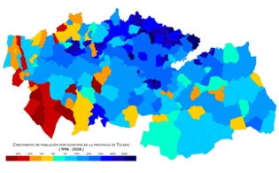
Population growth by municipality between 1998 and 2008

Population growth by municipality between 2008 and 2018


Politics
- Provincial Council
- Representatives in General and Regional Courts
Culture
.jpg)
Within the rich folklore of the province, the paloteos and other dances, parades, Castilian seguidillas, processional sounds and flag dances that in the past were often accompanied by dulzaina and tamboril stand out for their singularity. In some localities, these manifestations of popular folklore are already lost and in others they are performed with string instruments or by music bands, although the dulzaina and the tamboril are still preserved in certain municipalities. Some examples of all this are:
.jpg)
- Tinaní de Quismondo
- Paloteos and other dances of Escalonilla
- Stickers and other dances of Méntrida
- Jota de los Gigantones y Cabezudos o de la Dulzaina de Torrijos
- Horseback Riding, Carnival Welding Trailer Dance in El Carpio de Tajo
- Procession line, Castilian tails and La Mata rigodon
- Jota of Uncle Vicente, touch of procession of Saint Peter Chair of Antioch and Castilian followers of Carriches
- Dance of the flag during the holidays of the Christ of Charity of Santa Olalla
- Dance of the flag of Cebolla
- Danzas de Alcabón
- Seguidillas del cordón y paloteo de La Puebla de Montalbán
- Work the Gerindote cord
- Dance of the Santa Cruz de Retamar cord.
- Maqueda Dances.
- Tejetecordón en El Real de San Vicente
- Paloteos and other dances of Villacañas
- Paloteos and other dances of Villanueva de Alcardete
- The cord and other dances in Cabezamesada
- Dance or dance of the Cord of Villatobas
- Dances at Marjaliza Christmas Car
- Castilian followers and touch of procession of the saint in Carmena
- Dance of the flag and boot of the riff of Villaseca de la Sagra
- Danzas de Novés
- Castilian followers of San Juan in Huecas
- The dulzain was also used in the city of Toledo itself, at least until the centuryXIX, accompanying for example the gigantons and the gigantillas.
Contenido relacionado
Chimaltenango Department
Ejection cone
Carbajosa de la Sagrada