
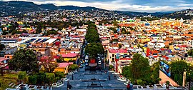
Tlaxcala
Tlaxcala, officially the Free and Sovereign State of Tlaxcala, is one of the thirty-one states that, together with Mexico City, make up Mexico. Its capital is Tlaxcala de Xicohténcatl and its most populated city, San Pablo del Monte. It is located in the eastern region of the country, bordering Hidalgo to the northwest, Puebla to the north, east, and south, and the State of Mexico to the west.
With 1,342,977 inhabitants in 2020, it is the fifth least populated state —ahead of Nayarit, Campeche, Baja California Sur and Colima—, with 4,016 km2, the least extensive, and with 291.32 inhabitants/km 2, the third most densely populated, behind the State of Mexico and Morelos.
It was founded on December 9, 1856. It is internally divided into 60 municipalities. The ancient Tlaxcalans allied themselves with the Spanish to defeat the Mexicas, after years of dominance by them, so this alliance gave them allowed to remain almost intact during 300 years of the viceroyalty period. It was recognized as a federal territory of Mexico in the Constitution of 1824, under dependence on the government of Puebla. In 1857 it became the twenty-second state of the republic. Its territorial administration it also changed from municipalities to parties, districts and again to municipalities. Between August and October 1995, sixteen new city councils were created.
Most of the state's economy is based on agriculture, light industry, and tourism. The tourism industry is based on the long history of Tlaxcala with the main attractions such as archaeological sites such as Cacaxtla and colonial buildings in the surroundings of the city of Tlaxcala.
The territory of Tlaxcala has two large plains: Calpulalpan and Huamantla. It has a temperate climate most of the year, which allows a great diversity of flora and fauna. This led to the settlement of human groups more than 8,000 years ago on the hill of La Gloria and the founding of the town of Atlihuetzia.
In pre-Hispanic times, Tlaxcala was one of the areas most populated by cultures such as the Olmec-Xicallanca to the south, which inhabited a thousand years before Christ, and the Otomi to the north. The mean altitude of the state is 2230 m a.s.l. no. m. (meters above sea level), favoring a temperate-subhumid climate in the central-southern part, semi-cold-subhumid to the north and cold in the vicinity of the La Malinche volcano; the highest point in the state.
Toponymy

The end point of the Tlaxcalan pilgrimage was the Sierra de Tepeticpac and the site chosen for the founding of the manor was called Texcallac (AFI: [teʃkal:ak] ), which in the opinion of Don Diego Muñoz Camargo means "cliff", thus describing the place to which the god Camaxtli had led them.
Due to phonetic corruption, Texcallac was changed to Tlaxcalla (AFI: [tɬaʃkal:a]), which changed its meaning of «cliff» to "place of tortillas or cornbread", since in the opinion of linguists, the word Tlaxcala comes from the Nahuatl "tlaxcalli" (AFI: [tɬaʃkal:i]) which means tortilla, but by modifying the ending lli to lla, the noun changes from singular to plural, meaning place of tortillas.
Even, the glyph that symbolizes the word Tlaxcala consists of two hills from which two hands emerge making a tortilla.
The letter «x» in the state name historically represented the phoneme /ʃ/ (a voiceless postalveolar fricative, the current «sh» sound), a sound that was written as X in Old Spanish at the time of the Spanish colonization and, later, in the alphabets of indigenous languages of America codified by the Spanish during the viceregal era. Due to phonetic changes in the language, the phoneme /ʃ/ came to be pronounced as a voiceless velar fricative (represented as /x/ in the International Phonetic Alphabet, the current "j" sound) at the beginning of a word and intervocalic, while it came to be pronounced as /s/ at the end of a syllable. In this way, Tlaxcala went from being pronounced [tlaʃkala] to [tlaskala]. In 1815, an orthographic reform of the Spanish language established by the RAE was carried out, which promulgated that the letter "x" be replaced by the letter "j" in words that historically had the phoneme /ʃ/ at the beginning of a word and intervocalically, leaving the letter «x» with the current pronunciation /ks/. However, several Mexican place names retained the letter despite the reform (including the very name of the country, Mexico). Due to this situation, the pronunciation [tlaks.kala] arose as an orthographic pronunciation of the place name.
Symbols
Tlaxcalan flag

According to the chronicles of Bernal Díaz del Castillo, in his Historia verdadera de la conquista de la Nueva España, it is noted that the distinctive colors of the Republic of Tlaxcallan included white and red, which were carried on banners and insignia.
For this reason, and with Tlaxcala already having a coat of arms, the inhabitants of the province decided to fly a flag that maintained the same indigenous past and the representative colors of the Republic prior to the conquest. The resurgence of the Tlaxcala flag has reinforced the identity of the state at a national and international level, which is why the state government carries it as a symbol of respect and cohesion.
In 2011, the municipality of Tlaxcala de Xicohténcatl gave legal recognition to the flag of Tlaxcala as a symbol of state identity: despite being one of the oldest flags that exist within the United Mexican States and that it had no official recognition, it was the third state flag of the country behind Tamaulipas and Jalisco.[citation required]
In the year 1535, Tlaxcala became the first city to be awarded the coat of arms by King Felipe II together with the title of "Very noble and very loyal city of Tlaxcala".
Shield

The shield dates from April 22, 1535, in the city of Madrid, Spain, and was issued by Emperor Charles V, and its description is as follows: The royal shield that Charles V and his mother, the queen Doña Juana, awarded to the city of Tlaxcala, is made on a red background from which a gold castle stands out with blue doors and windows of three towers, standing out in the middle a pavilion with a rampant eagle that dominates over a gold-colored field.
The first two letters correspond to the initials of the royal couple Isabel of Portugal and Carlos V, while the third alludes to the infant Felipe II of Spain, heir to the throne. Among the spaces for the initials, the two royal crowns that correspond to the aforementioned monarchs stand out. On the lower edge, in the center, two yellow bones crossed as crosses can be seen, and at the ends two skulls, the green palm branches symbolize the glory and greatness of Spain, and the greatness and glory of Tlaxcala.
The letters come from the initials of the kings of the Spanish Crown. The letter I comes from the Latin name of Queen Juana I of Castile known as Juana "La Loca", mother of Carlos I who was King of Spain and Holy Roman Emperor during the first half of the century XVI, period during which the conquest of Mexico took place, and to whom the letter K (Karolus) corresponds. The letter F comes from the initial of King Felipe II, son of Carlos V, who granted the title of "Very noble and very loyal" to the city of Tlaxcala. The castle of the field of gules is usually a symbol of the Kingdom of Castile, which by extension is often a symbol of the Crown of Castile and the kings of Spain. The saber eagle on the gold flag is a symbol of the Holy Roman Empire. It also symbolizes the victory of the battles won. And it is worth mentioning that the castle in which the flag with the eagle is located is a symbol of strength and power, greatness and wisdom.
Hymn to Tlaxcala
The Hymn to Tlaxcala was composed by Carlos Cea y Díaz, who was distinguished in the State of Tlaxcala for this work. Likewise, he was granted Tlaxcalan citizenship, without having been born in the entity. On October 26, 1986, a street in Tlaxcala was named after him, and the full Government welcomed him as a Tlaxcalan in the Auditorium of the Autonomous University of Tlaxcala, where he was named Distinguished Guest of the City.
History
Pre-Hispanic
Tlaxcalan

Tlaxcala and Tenochtitlán emerged in the indigenous world with two different political conceptions, which would inevitably clash. Tlaxcala developed a system of city-states that formed a republic, while Mexico-Tenochtitlán became an empire.
For many years the enemies of Tlaxcala tried to enter its territory, without managing to conquer a single inch of land. In turn, Tlaxcala could not go beyond its borders, until the Mexica in the year 1504, together with their Huexotzinca and Cholulteca allies, launched an offensive under the reign of Moctezuma II, being defeated before the thrust of the Tlaxcala; a second attack was also dismantled, having to withdraw the Aztecs and their allies.
In these wars, the legendary Tlahuicole was taken prisoner, who became a symbol of dignity and the struggle for autonomy of the Tlaxcalans. As a consequence of these wars, the city-states of Tlaxcala were subjected to an economic blockade, which prevented them from trading with the peoples of the Gulf and Central America, as well as those of the Valley of Mexico.
The myth of Quetzalcóatl was common to the peoples of Nahuatl origin, among them the Tlaxcalans. According to the oldest historian of Tlaxcala, Diego de Muñoz Camargo, Quetzalcóatl, within the religious conception of the Tlaxcalans, was the son of their god Camaxtli, who married Cuatlicue on his pilgrimage through the provinces of Culhuacán, Teotlacochcalco and Teohuitznahuac. The prediction of his return coincides with the appearance of the first Spanish expeditions and would become a catastrophe with the arrival of Hernán Cortés.
Conquest
"It is more inhabited than other provinces, and its inhabitants are the least oppressed in New Spain. They owe this favor to the alliance that their Republican predecessors made with the disciplined robbers that Cortez had commanded, and who had submitted to the Aztec empire. They are smarter than all Americans subject to Spain." -Thomas Kitchin, The Present State of the West-Indies: Containing an Accurate Description of What Parts Are Possessed by the Several Powers in Europe, 1778 |

When Cortés requested the permission of the Tlaxcalan Senate to transit through its territory towards Tenochtitlán, through the embassy of four main Cempoaltecans, the greatest opposition to letting them pass came from Senator Xicohténcatl Axayacatzin of Tizatlán, who governed the manor with his father Xicohténcatl -Huehuetl.
Xicohténcatl Axayacatzin argued in the Senate that the prediction of the arrival of the white and bearded men could be a hoax and that those travelers from the east might not be the ones they expected. He also said "that the floating castles were the result of human work, which is admired because it has not been seen." He proposed the reunion of the four lordships "so that they would regard foreigners as tyrants of the country and of the gods." This speech, contrary to the opinion of Maxixcatzin, Lord of Ocotelulco, decided the confrontations with the Spanish.
Cortés entered the territory of Tlaxcala through the ravine known today as La Mancera. In Tecoantzinco the Spanish had their first confrontation with the hosts of the lord of Tecoac. On September 2, 1519, Xicohténcatl faced Cortés in the Tecoantzinco gorge, with adverse results. The following day he fought on the plains of the same place, without the Tlaxcalan arms seeing his efforts crowned. The desertion of the divisions of Ocotelulco and those of Tepeticpac, due to the intrigues of Maxixcatzin, diminished the forces of Xicohténcatl who, thinking that the blond men won with the support of the sun, tried to defeat them in a night joust, which was also adverse to him.
Viceroyalty

Once the occupation of New Spain was consolidated, the viceroyalty was territorially divided into five major provinces, one of them being Tlaxcala. The province was governed by a mayor, on whom the four senators of Tlaxcala depended. At the end of the XVI century, the Spanish government elevated the mayoralty to a governorship with powers to exercise acts of justice, but with it the Tlaxcalan Senate also disappeared. Henceforth, the senators were simply called alcaldes mayores. These, in turn, had the power to appoint an indigenous governor, who together with the councilors appointed by the caciques, made up the Cabildo or Republic of Naturals.
The population began to decline since the confrontations with the Spanish and the capture of Tenochtitlán, as well as their participation with the captains of Cortés in various expeditions, discoveries and conquests, from which many did not return. Another factor that influenced the decline of the population was the colonization of the mining regions, which implied the migration of settlers to the current territories of San Luis Potosí, Sonora, Coahuila, Texas, etc.

Following the current highway from San Martín Texmelucan to Tlaxcala, you can still see the ruins of the chapel of Nuestra Señora de las Nieves, the place where the carts used to travel to the north of the country for the 400 families that went to populate, pacify and cultivate what was known at that time as "La Gran Chichimeca".
In the Tlaxcalan countryside, spacious and stately houses began to appear, with numerous rooms and wide corridors, where arches carved by indigenous hands could be observed; chapels for religious worship with decorated altars and sculptural images, and canvases that speak of the refined taste of their owners. Likewise, barns, warehouses, corrals for cattle, mechanical workshops for the arrangement of farming instruments and deep wells for irrigation were built. Gradually they were transformed into thriving haciendas and ranches, whose vestiges can still be seen along the paved roads of Tlaxcala. But with the haciendas also came the concentration of ownership. By the middle of the XVIII century, 217 haciendas concentrated just under half of the territory of the province. The conditions of the workers of the haciendas and ranches were less intensely exploited than those that took place in other provinces of New Spain, since they always had the protection of the indigenous Cabildo, who dealt with the hiring of the tlaquehuales (workers stationary), controlling the payment of taxes that the landowners should pay for them, in addition to ensuring that they do not withhold them for onerous debts.
Independence


.svg)
Given the weakness of the Spanish monarchy in confronting the Napoleonic occupation, the Central Government Board summoned the American provinces to elect deputies to represent them in the Cortes of Cádiz. Tlaxcala was not called for having an exceptional government. Only the tenacity of the indigenous Cabildo, which once again invoked the services rendered to the Crown and the privileges that it granted it, among them that of "Insigne, Very Noble and Very Loyal City", corrected the forgetfulness. Tlaxcala elected the brothers Manuel and Miguel de Lardizábal, descendants of Basques, and Dr. José Miguel Guridi y Alcocer, who participated in the elaboration of the Constitution of Cádiz and in honor of which, the city of Tlaxcala designated its Plaza de weapons like "Plaza de la Constitución".
The resurgence of the annexationist trend that had already failed during the colonial administration, had its source of support in the workers, merchants, landowners and part of the clergy of Tlaxcala, mostly of Spanish or Creole origin, with closer interests to Puebla.
The City Council of Tlaxcala, together with those of Chiautempan, Nativitas, Teolocholco, Xaltocan and Zacatelco, ordered their representatives before Congress to defend Tlaxcala as a Free and Sovereign State within the Union. The battle in Congress and in the journalistic media was waged by deputies Blázquez, Romero, Amador, González de la Cruz, Reyes and Zimerman, under the political strategy designed by Joaquín de las Piedras, Political Chief of Tlaxcala.
The prestigious legislator Mr. José Miguel Guridi y Alcocer, energetically protested before Congress for the claim of Puebla and the bad sons of Tlaxcala, managing to curb the petty ambitions of the annexationists. After a long and protracted discussion, Tlaxcala was not annexed as part of the state of Puebla, remaining as territory of the Federation. In 1836, when the states were transformed into departments, the territory of Tlaxcala was included within the Department of Mexico, until May 1847, when Tlaxcala regained its status as territory.
Reform
In 1853, Santa Ana returned to the Presidency of the Republic, through a coup. In March 1854 Don Juan Álvarez proclaimed the Plan of Ayutla, which aims to overthrow Santa Ana and restore the federal regime. The following year, the Tlaxcalan lawyer Guillermo Valle, and his supporters, adhere to the Ayutla Plan and, upon its triumph, he is recognized as Political Chief of Tlaxcala, integrating a Government Council and issuing a provisional organic statute, through of which it is proposed to politically organize the Tlaxcalan territory.

With the triumph of the Ayutla Plan, a Constituent Congress was called. Tlaxcala sent two representatives, who brought to the legislature the old demand that it be considered as a free and sovereign state within the Union, and not only as a territory.
Representative Mariano Sánchez made a broad historical defense of the Tlaxcalan struggle to obtain its autonomy, as well as a presentation in which he demonstrated the economic and social solvency of the entity. In a solemn session on December 9, 1856, the legislators overwhelmingly approved the proposal that Tlaxcala leave the status of territory and assume that of a free and sovereign state. Finally, after many vicissitudes in their struggle for autonomy, tenacity and historical reason happily prevailed. The following year, Guillermo Valle was elected governor of the state by the Constituent Congress of Tlaxcala.
The administration of Miguel Lira y Ortega was one of pacification and recovery for the battered economy of Tlaxcala. He promulgated a new Constitution in which he included the Reform Laws; he issued the Primary Education Law; it created new municipalities and gave broad support to the construction of railways. He joined Tlaxcala to the new textile technology with the establishment of 6 new spinning and weaving factories. He also dedicated a substantial part of the budget to the opening and maintenance of roads. Lira y Ortega supported President Benito Juárez against Porfirio Díaz's attempts to remove him from executive power. Upon the death of Juárez, Sebastián Lerdo de Tejada imposed Melquiades Carbajal in the governorship, leaving Miguel Lira and Ortega to go into voluntary exile to Puebla.
Mexican Revolution


The founders of the Antireelection Party of Tlaxcala were Juan Cuamatzi, Marcos Hernández Xolocotzi, Antonio Hidalgo, Diego and Trinidad Sánchez, Severiano Pulido and others. Sections of the political organization called anti-reelection centers were established in the main towns. On the other hand, the local anti-reelectionists recognized the regional leadership of the Puebla Revolutionary Board, led by Aquiles Serdán. The Revolutionary Junta agrees to rise up in arms on May 26, 1910, both in Puebla and in Tlaxcala. The revolutionaries from Santa Cruz Tlaxcala and from other towns concentrated in Contla and arrested the municipal president Nicolás Reyes, who escaped when he passed where there was a confrontation with the police. The revolutionaries surprisingly received orders from the Revolutionary Junta to suspend the uprising until further notice. Juan Cuamatzi and his followers headed for Cerro Blanco where they agreed to break up into small groups and await further instructions.
During factional fighting at the national level, fissures arise among the Tlaxcalan revolutionaries. Pedro M. Morales, former president of the Maderista Party, joins the ranks of Francisco Villa and Domingo Arenas to those of Emiliano Zapata. Only Máximo Rojas remained firm in the ranks of the constitutionalist army, which transformed the old Maderista Party into the Tlaxcalteca Constitutionalist Liberal Party. Domingo Arenas observed the events more carefully. In December 1916, he left the Zapatista ranks, rejoining those of constitutionalism. Don Venustiano Carranza named him military commander of the Alto Atoyac Basin in Puebla and Tlaxcala. Both Máximo Rojas and Domingo Arenas dedicated themselves to intervening the properties of the enemies of the Revolution, that is, of the most notorious members of the League of Farmers. But Domingo Arenas went further, distributing haciendas and ranches in the regions under his command without further bureaucratic procedures, practicing the agrarian ideals that were his own.
Mendoza maneuvered for Rafael Apango to be a candidate for state government for the Constitutionalist Liberal Party. The arenistas, through the Tlaxcalan Liberal Party, nominated Antonio Mora who, upon being defeated, rose up in arms, joining Cirilo Arenas, brother of Domingo Arenas. The capture and execution of Mora and Arenas in Calpulalpan, in addition to the death of Máximo Rojas by the Huerta rebels, helped to consolidate the power of the group of Ignacio Mendoza, who was governor with the support of his predecessor, Rafael Apango. In 1927, the city of Tlaxcala began to stabilize again after the war.
Contemporary period
The Agrarian Reform had replaced the hacienda regime and had created the subsistence base of the families, which were endowed with ejido plots whose extension reached an average of four hectares. The smallholders had one hectare per family. Some properties were denounced as simulated large estates, for which reason they were affected at the end of 1972, highlighting Santa María Zoapila, Sultepec, Piedras Negras, El Rosario and Mazioahuiz, benefiting 750 peasants.
.jpg)
Under these conditions, Lic. Emilio Sánchez Piedras assumes the governorship of Tlaxcala, who intends to put into practice a policy of modernization of the foundations of the Tlaxcalan economy. With great clarity, he perceived that the solution to the problem of land invasions lay outside the agricultural sector, since a minimum of one million hectares was required to satisfy the demand of the landless peasants.

There was no such land available in Tlaxcala, even if a private land acquisition policy had been implemented. Sánchez Piedras tempered the agrarian conflicts through a policy of expansion of the industrial plant, in such a way that the factories renewed transformation industries and improved the family and craft maquila workshops.
Thus, with a long-term program, Sánchez Piedras convinced a significant number of industrialists about the advisability of investing in Tlaxcala. With these purposes he founded in 1977 the Institute for the Industrial and Tourist Development of Tlaxcala.
During his administration, 250 companies were installed in the industrial parks built in 8 municipalities, which generated 33,200 jobs. Tlaxcala is, since then, an example of the industrial decentralization policy. The history of Tlaxcala cannot be understood without recalling the history of the four pre-Hispanic lordships of Tepeticpac, Ocotelulco, Tizatlán and Quiahuixtlán, whose inhabitants attended the founding of the capital of Tlaxcala in the XVI.
Geography
Location

The state is located in the central-eastern part of the country between the coordinates 19° 44' and 19° 06' North and 97° 438' and 98° 46' West. It limits for the most part with Puebla to the north, east and south, to the west with the State of Mexico and to the northwest with Hidalgo. The entity is located in the region of the Neovolcanic Axis, which crosses the central part of Mexico like a belt, from east to west, until reaching the sea on both sides. In the landscape there are volcanoes, volcanic mountains and extensive plains that were once lakes surrounded by mountains and forests, grasslands and thickets of temperate climate.
Extension


The state of Tlaxcala has an area of 4,016 km2, which represents 0.2% of the national territory. It is the smallest federal entity, only larger than Mexico City. It is divided into 6 judicial districts and 60 municipalities, with 794 populations. Tlaxcala has the shape of a rhombus, with the major axis in the East-Southeast-West-Northwest direction. Its eastern vertex is located on the easternmost slopes of the Sierra de Huamantla and the west on those of the Sierra Nevada, north of Iztaccíhuatl.
Its northern and southern extremes are located on the summits of two volcanoes. Respectively the Huintetépetl, to the north of Tlaxco; and the Malintzin (Malinche or Matlalcuéyetl) that dominates the Tlaxcalan panorama, with an altitude of 4461 m a.s.l. no. m. (meters above sea level) Tlaxcala is part of the Neovolcanic Axis that crosses central Mexico like a belt and extends from east to west towards the sea. It limits to the west with the Sierra Nevada, characterized by its imposing volcanoes: Popocatépetl, Iztaccíhuatl, Tláloc and others; to the east, with the mountainous massif that goes from the Cofre de Perote to the peak of Orizaba.
Its large plains, trapped by the high volcanic mountains, are cut by ravines and ravines, and have a volcano in Malintzin that, located in the southern part of the state, rises to reach 4640ms. no. m. and is one of its distinctive symbols. Its climate is temperate with the exception of the Malintzin summit, where it is cold. The rainy season runs from April to the end of October, hence its agriculture is temporary.
Relief

| Main elevations of the state of Tlaxcala | |
| Name | msnm |
| La Malinche (Matlalcuéyetl) | 4420 |
| The Huilotepec | 3500 |
| Huilacapitzo | 3500 |
| Cerro San Gabriel | 3340 |
| Huintetépetl | 3220 |
| Tlacoxolo | 3080 |
| Cerro San Nicolás | 3020 |
| Cuatlapanga | 2900 |
| Cerro Soltepec | 2860 |
| Source: INEGI | |

The state surface is included in the physiographic province: Neovolcanic Axis. In the state there is a plain that extends to the northwest and southeast of the state boundary.
The western zone is made up of mountain ranges of extrusive or volcanic igneous origin (they are formed when magma or molten rock comes out of the depths towards the surface of the Earth) such is the case of the La Malinche volcano, with an altitude of 4420 m s. no. m. (meters above sea level), separated by a plain and hills.
To the north there is a mountain range in the northwestern part that has developed a hillock. In the eastern part there are lowhills, mountain ranges and a small plateau-shaped mountain range where elevations are found higher than 3200 ms. no. m., the highest populations in the state are Calpulalpan and Tlaxco, with 2591 and 2588 m a.s.l. no. m., respectively, while the lowest height is located in the southwest of the state with 2200 m s. no. m..
Climate

99.2% of the surface of the state has a temperate subhumid climate, 0.6% has a dry and semi-dry climate, located towards the eastern region, the remaining 0.2% has a cold climate, located at the summit of La Malinche. The temperature annual average is 14 °C. The average maximum temperature is around 25 °C and occurs in the months of April and May. The average minimum temperature is 1.5 °C in the month of January.
The state average rainfall is 720 mm per year; the rains occur in summer in the months of June to September. In the state of Tlaxcala, most of the agriculture that is practiced is rainfed and the temperate sub-humid climate of the region favors the development of various crops such as corn, broad bean, beans, lettuce, spinach, amaranth, alfalfa, garlic, onion and cabbage, among others.
In the municipality of San Damián Texoloc, the climate is temperate sub-humid with almost regular rains from July to September with minimal winds. The months with high temperatures are March-June with maximum temperatures of 24.3 °C and the minimum with 7.2 °C. Due to these temperatures, their main crops are corn, beans and alfalfa.
In the municipality of Tlaxco, the climate is semi-cold with regular rains from July to October. The months with high temperatures are May to July reaching 28 °C and in the months of November to February it has a minimum temperature reaching some days below −1 °C. The month of December presents continuous frosts. Its main agriculture is corn, barley and wheat, among others.
- Tlaxcala bioclimatic landscapes

Sierra de Tlaxcala
Xicohténcatl Tlaxcala
Tepuente Forest
Nanacamilpa
La Vega
Zacatelco
Guadalupe
Acuitlapilco
Volcano La Malinche
Tlaxcala Valley
Sierra de Tlaxco
Tlaxco
Tepeyanco Hills
Tepeyanco
The Kings Quiahuitztlán
Totolac
Río Zahuapan
Xicohténcatl Tlaxcala
Villa Real
Terrenate
Razo Rancho
Nanacamilpa


.jpg)
.jpg)

.jpg)


Flora and fauna
Tlaxcala only has 17% of its surface covered with natural vegetation. The other part are agricultural crops, human settlements and dedicated to other types of activities, and it is in the natural areas where the greatest diversity and abundance of fauna is located. To date, 280 species of birds have been identified, of which 35 They are songbirds and ornamental. The highest richness of fauna is found in the La Malinche region and in the northwestern region of the state. Regarding mammals, the most frequent species are rabbits and opossums, and among the species with low populations are coyotes, armadillos, raccoons and wild cats.
The flora is comprised of maguey, fruit trees (plum, apricot, custard apple, peach, guava, fig, lime, lemon, apple, orange, walnut, pear, perón tejocote), grapes and xoconochtle. Among the fauna Domestically there are cattle, sheep, goats, pigs, donkeys and horses, poultry, dogs and cats. As for wildlife, there are squirrels, armadillos, cacomixtle, rabbit, coyote, hare, bat, ounce, rat house and field, mouse, badger, opossum, gopher, fox, skunk , owl, lizard, rattlesnake, mockingbird and buzzard.
- Flora and Fauna of the state of Tlaxcala

Vulpes

Crotalus
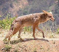
Canis latrans

Chiroptera

Coragyps atratus

Bassariscus astutus
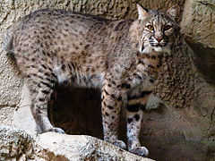
Lynx rufus

Dasypodidae

Mimus polyglottos

Didelphis marsupialis

Geomyidae
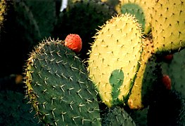
Opuntia ficus indica

Religious Abis
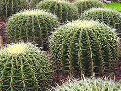
Echinocactus grusonii

Taxodium mucronatum

Agave

Prunus domestica

Prunus persica

Citrus × lemon
.jpg)


.jpg)


Hydrography
The main rivers of Tlaxcala are: Los Llorones, Zahuapan, Totolac, Altzayanca, El Lindero, Xalpatlahuaya, Atocha, Los Lavaderos-Tizar, Petatula, Rojano, Atotonilco, Grande, Texcalac, La Calzada, Tecoac, La Caldera, Atoyac, Viejo, Amomoloc, El Capulín, San Diego, Tenexac, Tlacaxolo, Atenco, Agegela, El Rosario, El Fondón, Santa Ana Ríos, San José, La Mancera, Las Lajas, El Bautisterio, Tepexilac-La Trinidad, El Águila and Xonecuila.
Demographics
Population

According to the data provided by the Population and Housing Census carried out by the National Institute of Statistics and Geography (INEGI) in 2020, the state of Tlaxcala had until that year a total of 1,342,977 inhabitants, of that amount, 650,000 were men and 692,977 were women.
The average size of households in the state is 4.3 people, while at the national level it is 3.9, according to the 2010 population census; however, by municipality it varies from 3.8 to 5 inhabitants per household.
In that same year (2020), the population density in the state of Tlaxcala is 336 people per square kilometer, while at the national level there are 64.3 people per square kilometer. Until that same year, 78% of the population live in urban locations and 22% in rural areas, data also obtained from the II Population and Housing Census carried out by the National Institute of Statistics and Geography (INEGI) in 2010.
Main towns
The following is a list of the main localities in the State of Tlaxcala, as reported in the 2020 census.
Metropolitan areas


The State Development Plan 2011-2016 establishes as a premise of the Executive Power, a new path to the development of the State; in the axis related to Balanced Regional Development, it primarily considers Territorial, Regional Planning and its Metropolitan Areas.
The metropolitan area of Puebla-Tlaxcala is made up of 20 southern Tlaxcalan municipalities, with a population of 338,313 inhabitants, and 19 municipalities make up the Tlaxcala-Apizaco metropolitan area, with 499,567 inhabitants, which This means that 43% of the state population is located in these two areas.
In the most recent study on metropolitan areas (ZM), published in 2005 by the National Population Council (CONAPO), the National Institute of Statistics and Geography (INEGI) and the Social Development Secretariat (SEDESOL), it was established that in the State of Tlaxcala there are only two metropolitan areas:
Puebla-Tlaxcala metropolitan area

The Metropolitan Zone of Puebla is the urban region resulting from the conurbation and interaction of several towns in the central municipalities of the state of Puebla and the south of Tlaxcala, in Mexico. This metropolitan zone is the fourth in terms of population in Mexico, after the urban agglomerations of the Valley of Mexico, Guadalajara and Monterrey, having 3,199,530 inhabitants according to data from the Population and Housing Census carried out in 2020 by INEGI.
Tlaxcala-Apizaco metropolitan area

It is an urban region located in the center of the State of Tlaxcala that by 2020 had 570,308 inhabitants, that is, 42% of the state population. In the central part of the ZMTA, there is a strong interrelation between the city of Apizaco with Tlaxcala de Xicohténcatl. These two cities have historically developed due to the constant flow of goods and human resources, given the communication allowed by the roads that connect both, without leaving aside the municipalities that are between the two municipal seats.
Territorial division
Municipalities


Tlaxcala has 60 municipalities (from August 1995 to October of the same year, 16 new municipalities were created). The creation of more municipalities in the smallest state in the country was not originally on the agenda of the local government, but In mid-1995, he considered that it was necessary to institutionally conduct this community aspiration and link it to the project of a new federalism, administrative decentralization, and democratization of local political life. Because of this, nine of the ten smallest municipalities in Mexico are located here.
Twenty-six municipalities have a name derived from Nahuatl, one from Spanish —Españita— and one combines roots from both languages —Terrenate—. Four municipalities take their entire name from a historical figure and another ten combine the surname with some term in nahuatl. In the same way, seventeen refer to a figure of the Catholic Church, all together with a Nahuatl denomination.
Finally, Nativitas is the only one that has its origin from Latin. The importance of knowing the etymological origin of the name of a municipality is reflected in the shield officially adopted to represent them. In addition, by listing certain characteristics of the natural landscape and human activities that are typical of each municipality, these shields and representations etymological have become an important element of municipal identity.
Regions
The Land Management Program of the entity (PEOT) structured these regions based on the road, natural, economic and social properties of the municipalities of Tlaxcala, each region is led by a municipality, where the greatest population development interactions are concentrated, thus dividing into; North (Tlaxco), East (Huamantla), West (Calpulalpan), Centronorte (Apizaco), Centrosur (Tlaxcala) and South (Zacatelco).
|  Map of the six socio-economic regions in which Tlaxcala is divided | |||||||||||||||||||||||||||||||||||||
Economy

.jpg)
The traditional agricultural economic activity of Tlaxcala has given way, as in many other states of the country, to industrialization and the service sector. In the 2006 edition of the System of National Accounts of Mexico conducted by the National Institute of Statistics and Geography, the Gross Domestic Product of the state is made up of 50% by the manufacturing industry, highlighting the lines of food and beverages; and the sector of community, social and personal services.
The commerce and tourism services sector, as well as real estate and financial services contribute with 14% and 12.4% respectively. The agricultural sector, despite its reduced economic participation, generates the greatest production of spines and mint in the country, as well as being an important supplier of roses, Creole peach, barley and wheat grain.

According to data presented by the state government, 27% of Tlaxcalans do not receive any income or receive a minimum wage, that is, they live in a very high state of marginalization. The concentration of this population occurs mainly in the rural areas and in those communities dedicated to agriculture. In addition, 36% of the population barely receives between 1 and 2 minimum wages, which means marginalized income for more than half of the Tlaxcalans.
It is worth mentioning that in terms of employment, the government has worked to expand the labor supply, since around 40% of the population works in "non-formal jobs"; and 18% are employed in the field with incomes of less than two minimum wages in most cases.
The ground transportation infrastructure has been one of the great advantages of the state since the beginning of its urbanization. In 2004, it had a road network of 2,434 km, and 351 km of railways. It is worth mentioning that Tlaxcala has an airport located 40 minutes from the center of the capital, in the municipality of Atlangatepec, and a heliport in the city of Tlaxcala.
Education


The formal state education system accommodates only 53% of students. Almost all the rest are enrolled in preschool education centers, indigenous education systems and other centers. Primary and secondary education is mostly provided by the Secretary of State Education.
Indigenous education is a system of preschools and primary schools that meet the cultural demands of the state's indigenous population. These are large and are located in the municipalities of Ixtenco, Contla de Juan Cuamatzi, San Pablo del Monte, Teolocholco, Tetlanohcan and La Magdalena.

Secondary school and vocational training is provided by the state school systems named CBTIS, CETIS, CECYTE, CBTA, COBAT and CONALEP. Most of these schools are vocational.
Higher education is provided by public and private institutions, the most important being the Autonomous University of Tlaxcala (UAT), which also offers the widest range of specialties spread across the different campuses around the state, such as those of Apizaco, Huamantla, Zacatelco and Chiautempan, as well as the Multidisciplinary Academic Units of Calpulalpan and San Pablo del Monte.
Other public universities and colleges include the Technological Institute of Apizaco, the Agricultural Technological Institute of Xocoyucan, the Lic. Benito Juárez State Normal School, the Technological University of Tlaxcala and as of February 21, 2021 the Interdisciplinary Professional Engineering Unit campus Tlaxcalteca (UPIIT) of the National Polytechnic Institute, this campus is located in plaza bicentenario in Tlaxcala de Xicoténcatl.
Private institutions include the Universidad del Valle, Universidad de Calpulalpan, Instituto Tecnológico de Tlaxcala and UPAEP.
In addition to the traditional education centers, there are technical training centers, state-run, which are considered an educational priority for Tlaxcala. These centers train people with short courses with industrial or commercial skills. Some of these centers include the Industrial Technological Training Center (CECATI) and the Tlaxcala Work Training Institute (ICATLAX). The state also has a system of libraries with 129 of them public located in 59 municipalities, with a collection of 588,758 volumes.
Tourism
Tlaxcala is the smallest state in the country and in that proportion it has 0.29% of tourist arrivals to the country. This percentage includes a little more than 278,000 visitors according to Sectur statistics in 2013, of which almost 5,000 are foreigners and 274,000 nationals, mainly from the neighboring states, Mexico City, the State of Mexico, Puebla, Hidalgo and Veracruz..
Ninety-five percent of the people who visit Tlaxcala are from Mexico and most of these are from the neighboring state of Puebla. Foreign visitors are mostly German, French and Swiss who are interested in the history of Mexico.
This influx corresponds to a monthly flow that has been measured to find the reasons for tourist activity in the State, confirming that Tlaxcala is a cultural and vacation destination whose average stay is 1.4 days, being more frequent on weekends. week, holiday periods of July-August and November-December where it coincides with the All Saints Fair.
Ecotourism is relatively new here, much of it centered around La Malinche National Park, which is home to the 14,636-foot (4,461-m) La Malinche volcano. Here you can camp, hike mountain biking, horseback riding, rappelling and climbing the volcano itself. At the Malinche peak, it is possible to see the Popocatépetl, Iztaccíhuatl (in Puebla / State of Mexico) and Pico de Orizaba (Veracruz) volcanoes.
- Main tourist destinations in Tlaxcala
Xicohténcatl Tlaxcala
Val'Quirico
Tetlatlahuca
Santuario delas Luciérnagas

La Malinche National Park
La Barca de la Fe
Tlaxco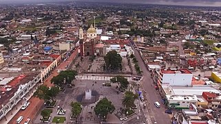
Zacatelco

Laguna de
Acuitlapilco
EDA Tourist Centre
Zacatelco
San Migueldel Milagro

Laguna de Atlangatepec

Laguna de Acomulco

Cacaxtla, Nativitas.


.jpg)


.JPG)
La Malinche National Park
Magic Towns
Since 2007, Huamantla was recognized by the Ministry of Tourism with the title of Pueblo Mágico, 8 years later, in 2015 Tlaxco became the second Pueblo Mágico in the state.
Culture
Folk Art


Some of the crafts have their origins in pre-Hispanic times, such as textiles, which were made on waist looms and with rudimentary techniques. They cleaned and macerated the fibers of the maguey, palm, lettuce and cotton, until making them flexible, then they dyed them with vegetable or mineral dyes.
In San Pablo del Monte, Talavera-type ceramics are worked, as well as onyx and popotillo paintings, in Ixtenco cotton garments are made, where Otomi embroiderers reproduce on the fabrics, without drawing, mixed pre-Hispanic and colonial figures; They also make rugs and pictures of different cereal seeds that form figures, landscapes and religious images.
On the other hand, in Tlaxco, silver goldsmiths are produced, where pre-Hispanic and colonial elements converge, using the lost wax technique. In Atltzayanca, sonority psalteries are made —tradition of the XVIII century—. Basketry in Nativitas and Santa Apolonia Teacalco. Glazed clay and griddles from Tzompantepec and Trinidad Tenexyecac.
While in Contla, Chiautempan and Ixcotla, sarapes, rugs and gobelins are manufactured where the shapes and colors of the Tlaxcalan ancestors are preserved, known as «saltillos». In San Sebastián Atlahapa an ancient artisan tradition is elaborated, "the burnished clay". And in Tlatempan, carnival masks are created. Likewise, in Ixtacuixtla, alebrijes, cardboard crafts and figures for floats are made. In Xaltocan the stonecutters shape table bases, planters, among others. Españita makes figures with dried corn leaves known by the name in Nahuatl as "totomoxtli" or "totomoxtle".
Archaeological zones


In Tlaxcala, according to information from the National Institute of Anthropology and History (INAH) and the Cultural Information System (SIC), 4 archaeological sites have been registered in the entity. Archaeological sites are those where evidence of previous human occupation has been found, and they do not necessarily correspond to pre-Hispanic sites, although most of them are. The area that concentrates most of these sites is the central and southern area where the ancient Tlaxcalans of the Republic of Tlaxcallan settled. The 4 archaeological sites correspond to Cacaxtla-Xochitécatl, Tizatlán, Ocotelulco and Tecoaque.

In Cacaxtla there is a group of murals from the pre-Hispanic era, such as the «Bird Man» and the «Jaguar Man». They belonged to the Olmec-Xicalanca culture and were discovered on September 13, 1975. They were painted between AD 750 and 800. C. In the Cacaxtla Site Museum, pieces that were found in the place are exhibited. For its part, Xochitécatl is made up of a set of monuments, being one of the oldest settlements in the Tlaxcala valley. The monuments and the archaeological pieces constitute an exemplary example of the cult of mountains and fertility.
The archaeological zone of Tecoaque, according to the National Institute of Anthropology and History (INAH), was the site where a Spanish caravan belonging to the Pánfilo de Narváez expedition was captured, who had the task of apprehending Hernán Cortés. Archaeological data corroborate this story and among the findings that support it are the skeletal remains of Spanish, black and mulatto men, women and children who were part of the caravan, in addition to a large number of European objects that they brought with them.
In Tizatlán, an alliance between the Spanish and the Tlaxcalans was agreed, which triggered the fall of the Mexica Empire. For this reason, rescued objects can be seen such as Tláloc figurines for ritual use, a collection of ceramics, basement plans, reproductions of the murals and altars of the Palace of Xicohténcatl "El Huehue". Upon the arrival of the Spanish, Tlaxcala was divided into lordships —Tepeticpac, Tizatlán, Quiahuiztlán and Ocotelulco. There is a figurehead where Xipe-Totec rests, and "the Flayed One", from whose mouth emerges Tezcatlipoca with a turquoise nose ring and an ocher band under his eyes.
Architecture
Finances
In 1874, the first cattle ranches such as Huizcolotepec and San José Tepeyahualco were founded, mainly for the arrival of the viceroys in Mexico. In the last decade of the century XIX La Trasquila, San José Atlanga, and San José de la Laguna arose. Currently, Tlaxcala is the state with the most cattle ranches in all of Mexico.
- Tlaxcala cattle ranching and flickering

Hacienda de San Bartolomé

Hacienda de Soltepec

Tenexac Treasury

Tlaxco cattle ranching


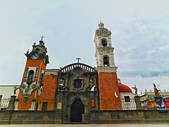
Religious Colonial Architecture
After the military conquest by Hernán Cortes ended, the Franciscan Order began the spiritual conquest in 1524, for which they built twelve convents, among which is the Cathedral of Tlaxcala, one of the first four continental ones in America in the capital of the province of Tlaxcala dedicated to the Virgin of the Assumption, as well as the Convent of Santa María de la Concepción, San Francisco in Tepeyanco, San Luis Obispo in Huamantla, San Judas and San Simón in Calpulalpan, the Franciscan Convent of Our Lady de los Ángeles in Chiautempan, among others. With the cedulación of these begins the construction of the diocesan temples of the baroque architecture of the XVII centuries and XVIII.
In this way, the baroque parishes of San Nicolás de Bari in Panotla, San Dionisio in Yauhquemecan, San Agustín in Tlaxco, Santa Cruz Tlaxcala, San Bernandino de Siena in Contla, Santa María Magdalena in Tlatelulco, Santa Isabel in Xiloxoxtla, San Francisco in Tepeyanco, Santa Inés in Zacatelco and San José in Tlaxcala.
- Religious colonial architecture in Tlaxcala

Parish San Antonio de Padua

Tlaxcala Cathedral

Basilica of Ocotlán

Santa Inés Parish
Parish of our Lady of Santa Ana

Temple of Saint Augustine


Other architectural complexes

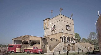
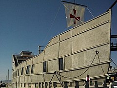
Among the contemporary constructions are those of the Gothic style and syncretism such as La Barca de la Fe in the north of Tlaxcala and the Minor Basilica of Mercy in the metropolitan area of Tlaxcala-Apizaco, these two only constructions different from the rest in the state of baroque style.

La Barca de la Fe is an architectural complex in the shape of a sailboat, created by the parish priest Arnulfo Mejía Rojas, located in the northeast of the state, in the town of José María Morelos Buenavista, where it also serves as a parish church and recreational area. Religious syncretism is the main thesis of the architecture and decoration of the temple.
In 1974, a project for a new temple began, with a rectangular shape but due to various events within the town, such as the separation of the town, the construction stopped and in 1984 a priest, Arnulfo Mejía Rojas decided, in a referendum with the population, to completely change the design of the church, to a larger one, in the shape of a boat.
In Apizaco is the Basilica of Mercy, which is a Gothic-style Catholic church, its construction dates from the XVII century, during the 1930s the original construction was demolished, to make way for the current architectural project inspired by the temple of the Sagrada Familia in Barcelona, Spain. On December 5, 1963 it was recognized as a Minor Basilica by the former Apostolic delegate of the Holy See, Luigi Raymondi, through the decree issued by Pope Paul VI in Rome erected on May 12, 1964. The church is compared to the cathedrals of the European continent.
National Heritage

In the 1980s, the National Institute of Anthropology and History (INAH) declared six areas of historical monuments in the entity as national heritage. The first site to receive this distinction It was the Historic Center of Huamantla, protecting 1.68 km2 made up of 86 blocks that comprise around 267 buildings, it was decreed and approved by President Miguel de la Madrid on October 25, 1984 and put into effect according to its publication in the Official Gazette of the Federation on November 12, 1984.
.jpg)
Two years later, on April 1, 1986, the Historic Center of Ixtacuixtla received the title of national heritage. In the following days, Miguel de la Madrid ruled the Historic Center of Calpulalpan, on April 3 of the same year, covering an area of 0.793 square kilometers made up of twenty-nine blocks that comprise approximately 64 buildings.
On April 4, 1986, the Historic Center of Apetatitlán was established, which covers 0.284 km2 made up of sixteen blocks that comprise around 51 buildings. The Historic Center of Tlaxco was established on April 9, 1986. Surrounding 0.57 km2 formed by eighteen blocks comprising approximately 109 buildings. Finally, the Historic Center of Tlaxcala was established on April 11 of 1986, which consists of an area of 0.503 km2 made up of 3 blocks comprising around 124 buildings built between the centuries XVI to XIX.
Gastronomy
Tlaxcalan cuisine is, like other Mexican cuisines, a mestizo gastronomy, although with greater indigenous influence enriched with Spanish ingredients that give shape to a variety of flavors, aromas, and colors. The Tlaxcalan people were a society that for a long time faced the Mexica empire, resulting in an isolation and commercial blockade for more than sixty years that deprived the Tlaxcalans of various ingredients from other provinces, such as sea salt and cocoa.. Said blockade forced the Tlaxcalans to take advantage of all the resources available to them. An example is tequesquite as a substitute for salt, obtained mainly from the Tequexquitla area.
- Typical Tlaxcala dishes

Traditional Tlaxcala Soup

Cocoa drink
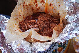
Tlaxcala Mixiotes


Traditions

Considered the cradle of the nation and miscegenation, in Tlaxcala the pre-Hispanic tradition is intertwined with the Spanish in festivals and popular fairs, where the Day of the Dead is celebrated from November 28 to 2. The altars are decorated with Chinese paper, where foods such as bread of the dead, mole, tamales, atole, sweet potato candies or pumpkin in tacha are placed. It is also decorated with cempasúchil flowers and lion's claw cultivated in the fields of the municipalities of Tepeyanco and Zacatelco.
Another of the illustrious celebrations of the entity is the Carnival of Tlaxcala, held during February and March. The dances of "huehues" are the most representative, formed between 20 and 40 couples, which are named according to the region to which they belong.

For example, the southern region, where the "charros" dance, who carry out the dance "la culebra", a dance propitiating rain. Also, there are litters of "Chivarrudos" in the south of the state, especially in Papalotla, Xicohtzinco and Zacatelco. The dancers dressed in leather pants and wearing hats made of sticks and colored paper make a remembrance of the times of Porfiarios when cattle were herded along the roads.
In the central region, the litters known as "Los Blancos" are concentrated, as in the communities of Ixtulco and Chiautempan. In the communities of Amaxac de Guerrero, Contla de Juan Cuamatzi, Santa Cruz Tlaxcala and Panotla, French gang dances are performed. The dancers are known as "Catrines" or "Levitas" due to the long coat like the pre-revolutionary custom in Mexico typical of mainly European foreigners, the top hat or camel hair straw and the umbrella that they use simulating the shape of dress as the bourgeoisie recalling the Hispanic.

The Tlaxcala fair was inaugurated for the first time by the President of the Republic Adolfo López Mateos, for which the exhibitor center was built by Governor Isidro Candia Galván, the first fair was held in 1963.
The fair takes place in the last week of October and the first three weeks of November, the 60 municipalities of the state participate in it, for craft and gastronomic samples; Likewise, bullfights, equestrian shows, livestock exhibitions and artistic presentations are implemented. The Tlaxcala fair has become one of the most recognized and important in Mexico.
The huamantlada is a copy of the Fiestas de San Fermín in Pamplona, Spain, for years it was carried out in the same way but in the 1960s it changed its name and shape from Pamplonada to Huamantlada. It consists of releasing fighting bulls that run through the street of Huamantla. One night before the event, the inhabitants of the circuit hold a popular festival enlivened with small music bands, a party that continues until the next morning. The Huamantlada was held for the first time on August 15, 1954 and arose at the initiative of fans, such as Raúl González and Jorge Aguilar who witnessed the Sanfermines during their stay in Spain.
Public relations
Sister States
The state of Tlaxcala is twinned with the following states:
 Puebla (2012)
 Veracruz (2012)
 Jalisco (2011)
 Mexico City (2014)
Contenido relacionado
Cylindrical projection
14th century BC c.
Antonio Vivaldi