This
The east (east in maritime) is one of the four cardinal directions. The perpendicular to the meridian intersects the horizon at points east and west. It is also called oriente or levante. It corresponds —although not exactly— to the point on the horizon where the Sun rises, hence the name levante (area where the Sun rises).
Etymology
The word east comes from Old English east, which in turn derives from Proto-Germanic *austra (German *austra > osten 'east'), and east from Proto-Indo-European *aus- meaning &# 39;dawn'.
The word east comes from the Latin orĭens,-entis, active participle of orīri ('appear, be born'), indicating the direction from which the sun and other stars rise or rise.
In Spanish it is common to use Levante to refer to the ordinal point, as well as to talk about the eastern part of the country (because the sun "rises" there). For example, the Levantine coast or the Mediterranean Levant. In the Patagonian region, the indigenous word cafuel is sometimes used to refer to the cardinal point.
Location
Cartography
On current maps, North is located in the upper zone, and consequently East is the right zone. On a compass, or wind rose, it is located 90º to the right of the direction indicating north. Maps that require precision indicate magnetic north and geographic north, which are different for each region. In all regions it can be observed how the Sun moves "apparently" from the horizon towards the west leaving the east to the right, if the observer is located facing north.
Through the heliacal rises
The Sun is in the ortho, exactly in the eastern cardinal point, on the only two equinox days of the year: Around March 21 and September 23. The rest of the year the solar rising gets to deviate from this position approximately 27 degrees to the north or to the south. The vox populi that the Sun rises (or rises) in the east is not completely accurate, deviating up to 27 degrees.
The east position is usually taken as a reference to determine in the astral chart design the sign of the zodiac that is ascending, that is, that "ascends" over the horizon at the instant in which it occurs an event, such as a birth, the coronation of a king, the election of a pope, and so on.
In gnomonics there is a time measurement system called «Babylonian» in which the origin of time is taken, not at noon, but the instant in which the Sun is in the rising.
Geopolitical uses
In Europe
The East (with a capital letter) designates the countries located to the east of the European continent, and, depending on the context, can include the southern Mediterranean countries, even some countries of the Balkans (for example, the orientalist painters of Romanticism of the XIX century). An adjective can be added to specify the geographical area: Oriente Próximo, Oriente Medio (term not recommended in Spanish, as it corresponds to Oriente Próximo ), Far East.
The Eastern Mediterranean countries are called Levante.
During the Cold War
The East (with a capital letter) has also been used to designate the countries belonging to the communist bloc throughout the Cold War during the periods from the 50s to the 90s. Contrast with West, which symbolized the United States of America. In Germany the inhabitants of the eastern zone were called "Ossis", as opposed to the "Wessis" from West.
After the Cold War, Eastern Europe includes the countries located in the eastern part of Europe.
Eastern Hemisphere
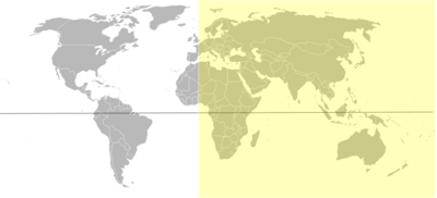
The Earth is divided into two hemispheres taking the Greenwich meridian as a reference (it was adopted as the 0º meridian at an international conference held in 1884 in Washington under the auspices of the US president), in such a way that there is a eastern (eastern) and western hemisphere. It is a purely geographical division.
In the eastern hemisphere are:
- All of Asia.
- Most of Europe.
- Much of Africa.
- Much of Oceania.
Contenido relacionado
The Aridane Plains
Bulnes orange tree
Territorial Organization of Cuba

