
The Rozas of Madrid
Las Rozas de Madrid or simply Las Rozas is a municipality in Spain belonging to the Community of Madrid, located in the metropolitan area, to the west of the capital. It is one of the municipalities with the highest per capita income in all of Spain. The municipality has experienced strong population growth, going from 35,137 inhabitants in 1991 to 95,725 registered on January 1, 2022. It was one of the first Spanish municipalities to be connected by motorway, inaugurating in 1967 the Northwest motorway.
History
According to some historians, Las Rozas de Madrid could be the old Miacum, so it could have its origin in the IIIth century. The municipality is located on the road that led from Segovia to the southeast, so its origin could be due to this circumstance. However, unlike Majadahonda, a town founded by shepherds, the name of Las Rozas indicates that its origin must have originated from the establishment of a crop area, since the word "roza" In Spanish, it designates the area that is being prepared for agriculture for the first time. And the beginning of the road to El Escorial in the city of Las Rozas itself explains that the true initial population boom took place in the century. XVI, coinciding with the establishment of the capital in Madrid and with the construction of the El Escorial Palace, since new agricultural areas were needed to supply the growing needs of the population.
During the reign of Carlos III, it was planned to create a utopian canal that would unite the Guadarrama river with the Manzanares and this with the Tagus until it reached the ocean through Lisbon. Very close to the Encinar de Las Rozas, in Las Matas, are the remains of the Gasco dam, built for this purpose.
On a map from 1755, the name of Matas Altas (Las Matas) appears, which was populated by workers who built the road that led to Segovia. Later it was from the RENFE factory from which said urban nucleus was nourished.
In 1812, the battle of Majadahonda was fought between that municipality and Las Rozas, which pitted French troops against Anglo-Portuguese troops, and ended with the victory of the former. In the middle of the XIX century, the place had a registered population of 455 inhabitants. The town is described in the thirteenth volume of the Geographical-statistical-historical dictionary of Spain and its overseas possessions by Pascual Madoz as follows:
ROZASthe): l. con ayunt. de la prov. y aud. terr. de Madrid (3 leg), part. jud. de Colmenar Viejo (4), c. g. de Castilla la Nueva, dióc. of Toledo (12); sit the N. of Madrid in uneven terrain; they combat all the winds; their climate it is cold and the most common diseases of catalysts; it has 70 houses of medium construction, of fast., school of first letters comun to both sexes, equipped with 1,300 rs. and a igl. parr. St. Michael Arcangel, served by a vicar of state patronage; he has an attachment to the oratory of Chescas, sit. on the Mount of the Pardo; the graveyard is parage that it does not offend public health and the vec. are springs for its uses of a source that is little dist. of the pobl. Confine the Term. N. Torrelodones; E. El Pardo; S. Majada-Honda and O. Galapagar: stretches 5/4 of leg. from N. to S and 1 1/2 of E. to O. and understands the cas. of the Hoz, houses of the canal of Guadarrama and the parador of San José, entitled of Matas-altas; there is a small mountain called dehesa, some vineyard and several meadows with medium pastures; it crosses the r. Guadarrama whose waters are used in part for irrigation: the field is of lower quality: roadsthose who lead to the neighboring villages, passing to the S. of the village the road from Madrid to the Coruña; the mail is received in the adm. of Madrid. prod., wheat, barley, rye, garbs, chickpeas, oats and grapes; it maintains lanar and cattle, breeds hare hunting and perdices and fishing of barbs, bogs and eels. ind. the agricultural and a flour mill. pobl.: 94 vec. 455 alm. cap. prod.: 1,510,603. imp.: 123,517. contr. 9'65 for 100.(Madoz, 1849, pp. 580-581)
During the Spanish civil war it became a zone of important combats, a reminder of this are the forts that can still be seen today in the Dehesa de Navalcarbón. In the winter of 1936, the rebel troops advanced through the west of Madrid from the areas of Brunete, Villaviciosa de Odón and Campamento. In the midst of dense fog and very low temperatures, the army of the Republic and the rebels, each one supported by their air force, faced off in one of the bloodiest battles of the Civil War in Madrid. Some inhabitants of Las Rozas took refuge in other places in the Sierra such as the caves of Hoyo de Manzanares, these roceños and roceñas were later called cucos.
- Examples of fortifications present at the Dehesa de Navalcarbón

Búnker

Búnker

Búnker

Trinchera
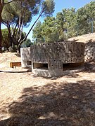
Búnker


The church of San Miguel and all the houses were completely destroyed. At the end of the war, the Ministry of the Interior created the General Directorate of Devastated Regions for the reconstruction of the towns destroyed by the war, among which was Las Rozas. By 1967, Las Rozas was already connected to Villalba, through one of the first Spanish highways, the A-6, the Northwest highway. In later years, the highway from Madrid was remodeled to give it capacity for the then new highway and for the El Escorial county road, then C-505 today M-505.
Geography
The municipality limits to the north with the municipality of Torrelodones, to the west with Villanueva del Pardillo and Galapagar, to the east with the neighborhood of El Pardo (Fuencarral-El Pardo district) and to the south with Majadahonda. Part of its municipal term is within the regional park of the Cuenca Alta del Manzanares.

| Northwest: Torrelodones | North: Torrelodones | Northeast: Madrid |
| West: Galapagar |  | This: Madrid |
| Southwest: Villanueva del Pardillo | South: Majadahonda | Sureste: Majadahonda |
Districts
The municipality is divided into three districts:
- North: Las Matas / Barrio de RENFE –TALGO / El Garzo / El Pedrosillo / Los Peñascales / Punta Galea / Sector IX / El Club de Golf / Los Jardines del César / Monte Verde / Buenos Aires / El Encinar
- Centre: Casco Urbano / El Pinar-Coruña 21 / La Marazuela / El Montecillo / El Abajón / Európolis / Dehesa de Navalcarbón / Yucatán
- South: Molino de la Hoz / El Cantizal / Parque Matas / Monte Rozas / Parque Empresarial / El Pinar / Parque Rozas / El Mirador / La Chopera
Situation

Despite being an independent municipality, Las Rozas forms an urban continuum with Majadahonda in the south. In fact, with the aim of saving due to the consequences of the 2008 economic crisis, the mayors of both towns signed an agreement to share services at the end of 2011. An example of this was the sharing of the Three Kings Parade from 2012 to 2017.
In addition, Las Rozas and Majadahonda share the following streets that run along the edge of the municipal area that divides both towns:
- Las Rozas Road to Majadahonda (former M-515 road). This artery of Las Rozas starts the roundabout that makes corner with the end of the street Real and connects with the end of the Avenida de los Reyes Católicos (Majadahonda). Specifically, with the number 15 on the sidewalk of the odds, where the Emissor Center of RTVE is located, and the number 18 on the side of the pairs. This is because in the locality the address of the numbers goes in the opposite direction as the avenue begins in the roundabout that makes corner with the street Doctor Calero to go in the north sense. On the other hand, 15 metres from the gateway to the RTVE enclosure, there is a 6-metre-high monoposte tricara of the Town Hall of Majadahonda indicating the entrance to the Majariego municipality. The main poster seen from Las Rozas announces the following: "Welcome to Majadahonda, where you live."
- Moncayo Street. The track belongs administratively to Majadahonda. The street starts its journey once it turns to the left on Jalisco Street and heading north end after going 50 meters from the corner of Santa Beatriz de Silva street (Majadahonda) closer to number 1. At this point it links with Calle Chiapas (Las Rozas), in which there is an automatic garage door of the private community number 4 of the same street. In this way, the end of the Moncayo Street connects with the end of Chiapas Street.
- Calle Virgen del Pilar. It belongs administratively to Las Rozas but the last 86 meters of the crossing are located within the municipality of Majariego. The street starts once it turns to the right on the street of Urbión and going south in the number 19 on the sidewalk of the odds and in the number 20 on the pairs. However, at the management level the street continues to belong to the Roma municipality for the next 45 meters until reaching the corner with Santa Beatriz de Silva street, numbers 15 and 17. Later, the route is called Calle del Jalón in Majadahonda to end in this section as a dead end.
- Calle de Monterrey. It is accessed by the Road of Las Rozas to El Escorial to start in the municipality of Roceño and move south until ending in the 10B number opposite the traffic islet located more north of the Plaza de Mexico. From then on, enter Majadahonda with the number 2 that appears again until it ends in number 19 on the sidewalk of the odds and on the 20th on the sidewalk of the pairs as a street without exit in the form of a roundabout.
- Mexico Square. It starts in Las Rozas once the route of the street of Monterrey ends in the Roma municipality. Numbers 1 and 2 belong to this town and the municipal term also covers a part of the traffic islet that is more north of the roundabout. On the other hand, numbers 3, 4, 5, 6 and 7 belong to Majadahonda and the municipal term includes the roundabout and the traffic islet located more south.
- Calle de la Virgen de Guadalupe. It belongs administratively to Las Rozas but the last 25 meters of the street are within the municipality of Majariego. The street starts once it is turned to the right on the street of the Cornisa (Las Rozas) and transiting towards the south ends at the height of the Pentagon Park of the Rosa de los Vientos (Majadahonda).
- Hurricane Street. Start your tour turning right on Navaluenga Street from Las Rozas heading east. The last 50 meters at the end of the street are located in the municipality of Majariego and cover three numbers. In fact, the number 3 appears again in the final part of the street and does so in what would be the sidewalk of the pairs if you make the tour from La Rozas. This is because this number belongs administratively to Majadahonda and Hurricane Street begins in the reverse direction in this town as it is accessed by the street of the Tramontana. Finally, the number 39, which is located on the side of the street that corresponds to it, belongs administratively to Las Rozas although it is located within the municipality of Majariego.
- Tramontana Street. The division of the municipal term is defined by the end of the perpendicular Calle Huracán, which marks the point that separates the street between the two municipalities. The northernmost part of Hurricane Street is part of Las Rozas and the southern part belongs to Majadahonda. As for the numbering, in the municipality of Roceño the street begins once it is accessed by the Road of Las Rozas to El Escorial to go in the south direction and finish in the number 29 on the sidewalk of the odds and in the number 16 on the sidewalk of the pairs while in the town majariega the street Tramontana starts after making a turn to the right in the Calle Rosa de la Vientos to finish in the number 39 Thus, the end of the street on the Rozas connects to the end of the street in Majadahonda.
- Breda Street. The numbers that go from 1 to 13 on the sidewalk of the odds and from 4 to 14 on the sidewalk of the odds are within the "Residencial Bellavista" Urbanization and ends in a dead end in the form of a roundabout. General access is not allowed because it is private property. However, the number 2 although belonging to the urbanization is located outside the enclosure. Going south from this point, the rocky street arrives at the corner with the Siroco Street of the Majariego municipality and empalma with the end of the Navaluenga Travesy (Majadahonda). This route begins once it is turned to the right by the Road of El Plantío and going in the north sense ends in the number 33 on the sidewalk of the odds and in the 44 on the side of the pairs.
On the other hand, in the north of Las Rozas it also forms an urban continuum with the municipality of Torrelodones between the areas of Las Matas and Los Peñascales. For this reason, the following streets cross the border of the municipal term that divides both towns:
- Gabriel Enríquez Street of the Order. The beginning of the street is in the municipality near the Peñascales Travesy, accessing it by exit 26 (Las Matas / Los Peñascales) of the A-6 (kilómetro 26) or through the Service Way of that highway going northeast. In this first section, the odd numbers end in 13 while the pairs end in 8. Once the crossing arrives at the corner with Calle Espliego, enters Torrelodones where it is called Avenida Gabriel Enríquez de la Orden. From this part of the way forward, the sidewalk of the pair numbers is within the municipality of Las Rozas and ends in the number 32 while the sidewalk of the odd numbers is inside the territory of Torrelodonense to end in the number 35.
- El Enebral Street. The road is accessed through Avenida Gabriel Enríquez de la Orden or Calle Espliego and heading west end at the A-6 Service Way. The pavement of the odds, in which only the number 1 is located in a corner, belongs administratively to Torrelodones while the sidewalk of the pairs, which includes the numbers 2 and 4, is part of Las Rozas.
- Avenida de Pinares. It enters at the beginning of the journey once it turns to the right in the Gabriel Enríquez of the Order passing in the northeast direction. The first 90 meters of the road are part of Torrelodones at administrative level while the rest of the avenue belongs to Las Rozas. Specifically, the numbers 1 and 2 of the avenue form part of the municipality of Torrelodonense. In the latter issue, the Centre for Major Health (Residency and Day Centre with the Social Policy and Family Council of the Community of Madrid) is accessed. Then the journey is already entering the Rocky town in which it ends in number 9.
Climate
 Average climatic parameters of municipality of Las Rozas de Madrid (Reference period: 1971-2000) Average climatic parameters of municipality of Las Rozas de Madrid (Reference period: 1971-2000) | |||||||||||||
|---|---|---|---|---|---|---|---|---|---|---|---|---|---|
| Month | Ene. | Feb. | Mar. | Open up. | May. | Jun. | Jul. | Ago. | Sep. | Oct. | Nov. | Dec. | Annual |
| Average temperature (°C) | 10.1 | 12.4 | 16.0 | 17.9 | 22.1 | 27.8 | 32.4 | 31.9 | 27.1 | 20.1 | 14.1 | 10.6 | 20.2 |
| Average temperature (°C) | 5.4 | 7.1 | 9.7 | 11.6 | 15.5 | 20.6 | 24.4 | 24.0 | 19.9 | 14.3 | 9.0 | 6.3 | 14.0 |
| Temp. medium (°C) | 0.6 | 1.8 | 3.6 | 5.4 | 9.0 | 13.3 | 16.4 | 16.1 | 12.8 | 8.5 | 4.0 | 1.9 | 7.8 |
| Total precipitation (mm) | 46 | 38 | 28 | 52 | 56 | 31 | 17 | 15 | 32 | 58 | 64 | 66 | 508 |
| Source: State Meteorology Agency | |||||||||||||
Communications
Roads
Nationals
- The road of the Coruña passes through the municipality, although physically it has been absorbed from approximately p.k. 17'5 by the A-6
Highways and highways

- Northwest highway. It contains the platform with two Bus-VAO lanes in the median. This is extended to close to the km. 20 of the motorway, already with one lane.
- M-50 circumvalration autopist.
- M-505 road between Madrid and El Escorial. Starts in the municipality, at Exit 18 of the A-6.
Autonomous and regional
- M-851 Road, from Las Rozas to Villanueva del Pardillo. Start at km. 3 of the M-505 road and end at km. 9 of the M-509 road.
Old roads
- M-515 Road. On some maps like M-5140. Old road from Las Rozas to Majadahonda. He no longer owns the identifier.
On the A-6 motorway, near km. 20, the place where the new gravel-cement platforms began to be built in Las Rozas in 1966.
Renfe commuter trains


Las Rozas had five stations until Los Peñascales and El Tejar were abolished. There are currently those of Las Rozas, Las Matas, El Pinar, the last two on the Madrid to Hendaye railway. In this way, Las Rozas has one of the best communications with the center of Madrid in the entire Community. Also including the old Madrid-Hendaye route from Príncipe Pío, where Las Rozas Station is located, and which later links up with the current one from Chamartín.

| Line | Tour | Stations |
|---|---|---|
 | Santa María de la Alameda - El Escorial - Chamartín - Sol - Atocha - Aranjuez | Las Matas Δ Pinar |
 | Alcalá de Henares - Atocha - Chamartín - Prince Pio | The Rozas |
 | Guadalajara - Atocha - Chamartín - Villalba - Cercedilla | Las Matas Δ Pinar |
 | Villalba - Prince Pio - Atocha - Chamartín - Fuente de la Mora - T4 Airport | Las Rozas Δ Las Matas Δ Pinar |
Buses
Las Rozas is accessible both from the A-6 highway (La Coruña highway), and from the M-50 highway (Madrid ring road) or from the M-505 (El Escorial highway), therefore, This gives the municipality good communication for public transport.
| Line | Tour |
|---|---|
| 1 | Las Rozas - Urbanization Mill of the Hoz |
| 2 | Las Rozas - Monte Rozas - El Encinar |
| 561 | Madrid (Aluche) - Pozuelo de Alarcón - Majadahonda - Las Rozas de Madrid |
| 561A | Madrid (Aluche) - Pozuelo de Alarcón - Majadahonda - Las Rozas de Madrid (by University) |
| 561B | Madrid (Aluche) - Pozuelo de Alarcón - Majadahonda - Las Rozas de Madrid (by Avda. Guadarrama) |
| 620 | Las Matas - Hospital Puerta de Hierro |
| 621 | Madrid (Moncloa) - Las Rozas |
| 622 | Madrid (Moncloa) - Las Rozas - Las Matas |
| 623 | Madrid (Moncloa) - Las Rozas - Urbanization Villafranca |
| 624 | Madrid (Moncloa) - Colegio Veracruz - Las Rozas |
| 625 | Madrid (Moncloa) - Monte Rozas |
| 626 | Las Rozas - Majadahonda - Villanueva Cañada |
| 627 | Madrid (Moncloa) - Las Rozas - Majadahonda - Villanueva Cañada - Brunete |
| 628 | Madrid (Moncloa) - Parque Empresarial - El Cantizal |
| 629 | Madrid (Moncloa) - Las Rozas (Parque Empresarial) |
| FS1 | Las Rozas (CC Herón City/Las Rozas Village) - Valdemorillo |
| N903 | Madrid (Moncloa) - Las Rozas - Monte Rozas |
In addition, other intercity lines pass through Las Rozas, such as line 631 that connects Moncloa with Galapagar and Colmenarejo. Dozens of interurban bus lines to other municipalities also pass through the A-6 motorway, which, although they do not have a stop in Las Rozas, have to pass, as the municipality is located in the northwest corridor, formed as a result of the N-VI, La Coruña highway. Some of them have one or two sporadic stops, for example line 611 (Moncloa-Hoyo de Manzanares) of Larrea S.A., which at some times passes through Las Matas Station, (always doing so 611A), and at other times in front of to Burgocentro, on the El Escorial road, kilometer 1.
Administration and politics
The Town Hall and the Hall of Flags are located in the center of the city. Specifically, in Plaza Mayor, 1. Access to the Town Hall Plenary Hall building is located next to the town hall on Avenida de los Toreros, 2 (corner Calle Quicos). Currently, elected 25 councilors (absolute majority in 13).


Political parties in the City of Las Rozas 2019 | ||||
| Political parties | Councillors | |||
| Popular Party | 12 | |||
| Citizens | 6 | |||
| Socialist Workers Party | 4* (2 councilors went to the non-adscribed group) | |||
| Vox | 2 | |||
| We can. | 1 | |||
| Period | Name | Party |
|---|---|---|
| 1979-1983 | Benito Garrido Turrillo (1979) Luis Schake de Miguel (1979-1980) Lazaro Mingo (1980-1981) Luis Schake de Miguel (1981-1983) | PSOE |
| 1983-1987 | Jesús Zúñiga Pérez-Lemaur | PSOE |
| 1987-1991 | Jesús Zúñiga Pérez-Lemaur | PSOE |
| 1991-1995 | Jesús Zúñiga Pérez-Lemaur | PSOE |
| 1995-1999 | Bonifacio de Santiago Prieto | P |
| 1999-2003 | Bonifacio de Santiago Prieto | P |
| 2003-2007 | Bonifacio de Santiago Prieto | P |
| 2007-2011 | Bonifacio de Santiago Prieto | P |
| 2011-2015 | José Ignacio Fernández Rubio | P |
| 2015-2019 | José de la Uz Pardos | P |
| 2019- | José de la Uz Pardos | P |
Population
The population of Las Rozas is 95,071 inhabitants, where 10% were born in the municipality, 52% have emigrated from other municipalities in the community of Madrid, 24% from other autonomous communities,1 4% from other countries.
| Population pyramid 2017 | ||||
| % | Men | Age | Women | % |
| 0.5 | 85+ | 1.3. | ||
| 0.6 | 80-84 | 0.8 | ||
| 0.8 | 75-79 | 0.9 | ||
| 1.5 | 70-74 | 1.5 | ||
| 2.0 | 65-69 | 2.3 | ||
| 2.3 | 60-64 | 2.5 | ||
| 2.8 | 55-59 | 3.3 | ||
| 3.7 | 50-54 | 4.0 | ||
| 4,5 | 45-49 | 4.9 | ||
| 4.6 | 40-44 | 5.2 | ||
| 3.6 | 35-39 | 4.0 | ||
| 2.8 | 30-34 | 3.1 | ||
| 2.5 | 25-29 | 2.4 | ||
| 2.6 | 20-24 | 2.5 | ||
| 2.9 | 15-19 | 2.9 | ||
| 3,8 | 10-14 | 3.7 | ||
| 3.7 | 5-9 | 3.5 | ||
| 3.1 | 0-4 | 2.9 | ||
| Graphic of demographic evolution of Las Rozas between 1900 and 2022 |
 |
Source: Spanish National Statistical Institute - Graphical development by Wikipedia. |
Culture

Joaquín Rodrigo Municipal Auditorium
In 1999 the building that houses the Department of Education, the Official School of Languages, the Department of Culture, the School of Music and Dance, the School for Adults and the Municipal Music Auditorium was inaugurated. Las Rozas City Council promotes a wide variety of cultural activities: exhibitions, courses, workshops, trips.


Libraries
Las Rozas has three municipal libraries and has been recognized with the 2018 Liber Award for the best initiative to promote reading in libraries open to the public (awarded by the Federation of Publishers Guilds of Spain):
- Las Rozas Library (built in 1991)
- Biblioteca de Las Matas Marga Gil Roësset (constructed in 1999)
- León Tolstói Library (built in 2008)
Las Matas Railway Museum
It was inaugurated in 2009 with the aim of presenting and documenting the evolution of the railway in the Las Matas neighborhood, originally built to house the workers, with a church (current site of the museum) and a school. The neighborhood of Las Matas preserves the railway town.
Natural spaces and biodiversity
Las Rozas has about 29 km² of forest areas, of which 23 km² are concentrated between the Cuenca Alta del Manzanares regional park and the Curso Medio del Guadarrama regional park.
Film Studies

During the sixties of the XX century, Las Rozas was home to a large movie set. The producer Samuel Bronston built, in what is now a luxury urbanization in Las Matas, the most important film studios in Europe and they aimed to be the largest in the world, but commercial failures such as the film 55 days in Peking (1963) prevented us today from talking about Las Rozas as the headquarters of the film industry. In the filming of 55 days in Beijing, many from Roceños participated as extras, and also as workers in the construction of the sets. An artificial river was even created that was filled with tankers.
To remember Samuel Bronston, who was buried in Las Rozas, the street that crosses the Dehesa de Navalcarbón was named.
Place of worship

Church of San Miguel Arcángel: In late-Gothic style, the parish church of San Miguel Arcángel, rehabilitated after being destroyed during the Civil War, stands on a rise in the ground, coming out to the south of the Plaza de España.
Education
- I Cycle of Children ' s Education: The municipality of Las Rozas has four children ' s schools in the Community of Madrid Public Network, which cater to more than 500 children aged 0-3 years.
- II Infant and Primary Education Cycle: Las Rozas currently has ten Public Centres (CEIPS) and six Concerted Centres (CC) for Child and Primary Education.
- Secondary education: Las Rozas currently has five public centres.
Popular festivals

- September 29: San Miguel Arcángel. To celebrate the patron of the village are organized bulls and bullfights, concerts, giant paellas and popular contests.
- Monday following the May Bridge: Virgin of La Retamosa. The Virgin of the Retamosa is transferred in procession from the church of San Miguel Arcángel to the hermitage located in the Dehesa de Navalcarbón, once there is a pilgrimage with dance and contests.
- May 1st: San José Obrero (Las Matas). Pattern of the neighborhood, runners and bullfights and concerts are organized.
- 6 January: When the 12th of the night of kings is fulfilled, the fifth light the fire that they have been preparing throughout the day, this tradition is being lost lately for two main reasons, on the one hand the objective was to bring together all the mozos that that year would do the military service (the mili), today when it has been suppressed does not make so much sense and on the other hand the continual change of place of the hose areas where it is placed in the mass construction. First it was in the Plaza Mayor, then in the Plaza de España, then where today there is an urbanization, right next to the Auditorium and finally its current location will have to change soon due to the requalification of the lands, the valley of the eco or the montecillo.
Sports

Las Rozas has always been closely linked to sport, as evidenced by the awards received over the last thirty years:
- 1991 National Sports Award.[4]
- 1998 Seven Star Sport Award from the Community of Madrid.
- 1999 National Sports Award.[5]
- 2016 European City of Sport: a distinction officially handed over to municipal officials in November 2015 at the headquarters of the European Commission in Brussels.
- 2016 Premio Seven Stars of the Sport of the Community of Madrid.
In the municipality is the headquarters of the Royal Spanish Football Federation, in the facilities of the Soccer City of Las Rozas since 2003. It is also the headquarters of the International Federation of Bodybuilding.
The main sports associations in Las Rozas are:
| Sport | Club | Palmarés | League | sports complex |
|---|---|---|---|---|
| Football | The CF Rots | Third Federation | Municipal Sports Police Dehesa de Navalcarbón | |
| Basketball | Club Basketball Las Rozas | Polideportivo San José de Las Matas, Polideportivo de Entremontes | ||
| American Football | The Black Demons Rozas | 1 North Conference (2012) | LNFA | The Cantizal |
| Rugby | Industrial Engineers Las Rozas Rugby | Division of Honor B | The Cantizal | |
| Hockey on skates | Club Patin Las Rozas | OK Female League | ||
| Hockey | Club Hockey Caníbales Las Rozas | The Abbey | ||
| Artistic Line Skating | Club Elite Skating Las Rozas | |||
| Floorball | CUF Las Rozas | CAM League | Polideportivo de Entremontes | |
Economy
The municipality has numerous shopping and leisure centers as well as a business park. 93.3% of the population work in the service sector.
Debt evolution of Las Rozas:
| Evolution of the debt of Las Rozas since 2008 (m.€) [6] |
|---|
 |
Business Park
Las Rozas has developed a business park in order to create an area of attraction for the implementation of the headquarters of companies or the central offices of various sectors:
- Technology: BQ, DXC, Hewlett-Packard Enterprise, HP Inc, LG, Micro Focus, Oracle
- Banker: ING, CaixaBank
- Food: DIA Group
Shopping and leisure centers

- BurgoCentro: Inaugurated in May 1987, with 240 premises distributed on four floors (shops, supermarket and fast restoration).
- Európolis[7]: Commercial area created in 1993, of 750 000 m2, about 800 shops, industries and restaurants where more than 5000 people work.
- The Style Outlets: First outlet opened in Spain in 1996 (commercial center of textiles, accessories and home, including a catering service).
- Las Rozas Village: Inaugurated in May 2000, with 95 large brands, where about 1000 people work. According to statistics from 2016, about 4.5 million people visit Las Rozas Village a year, where 40% are foreigners.
- Heron City: Inaugurated in 1999, it is a leisure centre with a 24-room cinema with IMAX® technology, shops, a wide variety of restaurants and a gym.
Notable people
Contenido relacionado
Holy Cross of La Palma
Saint Peter of the Valley
Population density