
The Realejos
Los Realejos is a Spanish municipality belonging to the island of Tenerife, in the province of Santa Cruz de Tenerife, autonomous community of the Canary Islands. The municipal capital is located in the urban area of Los Realejos, located about 327 m s. no. m.
The modern municipal term was formed by the merger, in the middle of the xx century, of the municipalities of Realejo Alto and Realejo Bajo. Together with the neighboring municipalities of La Orotava and Puerto de la Cruz form the Valle de La Orotava Metropolitan Area with 108,721 inhabitants (2019).
Toponymy
The name of Los Realejos was imposed in 1954 when the towns of Realejo Alto and Realejo Bajo were unified. Likewise, the name of the municipality derives from the term realejo "place where an army is encamped", as it is the place where the conquering Castilian army had established its base in the last phases of the conquest of the island in 1496.
Another hypothesis proposes that the term Realejos derives from two camps of the forces in conflict: the Realejo Alto would be the camp of the conquistadors, while the Realejo Bajo was that of the Guanches.
Symbols
Shield
The heraldic shield of the municipality was approved by agreement of the Council of Ministers on March 6, 1959, its description being: «Split shield. First, gold, a purple banner and a Guanche añepa with a mat of sinople palm leaves, crossed in an X and crowned by a cross of Santiago de gules. Second, gules, three well-ordered gold castles, with a gold chain that hangs from the battlements of the two chief's castles and from the center of which hangs a gold key. At the bell, Royal Crown open."
The arms of the town of Realejo Alto are represented in the first barracks; the banner and the crossed añepa or scepter allude to the peace signed between the conquistadors and the Guanches on the day of Santiago Apóstol in 1496, hence the cross of the Order of Santiago. The second quarter represents the arms of Realejo Bajo; three castles linked by chains that represent the old fortresses that defended the territory.
Flag
The municipal flag has a rectangular shape and is divided into two horizontal stripes of equal width, the upper one being light blue and the lower one white. In the center of the cloth is the shield, whose height is 2/5 of the width of the flag.
Physical geography
Location
It is located in the north of the island, in part of the La Orotava valley, 41 kilometers from the capital, Santa Cruz de Tenerife. It limits with the municipalities of Puerto de la Cruz, La Orotava and San Juan de la Rambla.
It has an area of 57.5 km², ranking 12th on the island and 20th in the province.
The maximum height of the municipality is reached in the area known as El Cabezón, at 2166 m a.s.l. no. m.
Orography
The coast of Los Realejos is high and steep, and has five black sand and pebble beaches: Castro, Los Roques, El Socorro, La Fajana and La Grimona.
These coastal corners have particular characteristics, such as La Piedra del Camello, a rocky complex that seems to watch over the coastline; the Callabuzo, an inlet, frequent whereabouts of molluscs and marine hunting ground; El Guindaste, a popular bathing place, with its saltaderos and a set of natural pools created by the action of historical eruptions; El Ingenio, La Laja, etc. But if there is a popular and famous coastal corner among the realejeros, it is, without any doubt, El Socorro beach.[citation required]
Hydrography

Numerous ravines cross the municipality, of which the following stand out: Cerrudo, Palo Blanco, Godínez, Los Príncipes, Madre Juana, La Torre, El Roque and Ruiz ravines.
Climate
| Month | Ene. | Feb. | Mar. | Open up. | May. | Jun. | Jul. | Ago. | Sep. | Oct. | Nov. | Dec. | Annual |
|---|---|---|---|---|---|---|---|---|---|---|---|---|---|
| Average temperature (°C) | 17.9 | 18.1 | 19.3 | 20.0 | 21.2 | 23.1 | 25.6 | 26.9 | 25.5 | 23.8 | 20.8 | 18.8 | 21.8 |
| Average temperature (°C) | 14.8 | 15.0 | 15.9 | 16.4 | 17.6 | 19.4 | 21.7 | 22.6 | 21.9 | 20.3 | 17.7 | 15.7 | 18.3 |
| Temp. medium (°C) | 11.7 | 11.9 | 12.5 | 12.9 | 14.0 | 15.8 | 17.8 | 18.3 | 18.4 | 16.8 | 14.7 | 12.7 | 14.8 |
| Total precipitation (mm) | 64 | 50 | 46 | 23 | 11 | 4 | 1 | 1 | 8 | 42 | 76 | 82 | 408 |
| Source: Climate-data.org | |||||||||||||
Nature
Flora

The municipality preserves abundant samples of typical Canarian vegetation. On the steep and rocky coast there is a halophytic belt made up of low scrubs of sea thyme Frankenia ericifolia and sea lettuce Astydamia latifolia, with some copses of tamarisk Tamarix canariensis near the mouth of the Ruiz ravine. Above the coastline, and sheltered in the cliffs under Icod el Alto, communities typical of the Canarian thermophilic forest develop, standing out the presence of junipers Juniperus turbinata, bitter tabaibales of Euphorbia lamarckii, thickets of black firewood Rhamnus crenulata and granadillos Hypericum canariense, as well as willows of Salix canariensis on the wetter crags and communities of bejeques Aeonium canariense with pipes Sonchus congestus on the escarpments. In these areas there are also abundant replacement scrubs made up of incense Artemisia thuscula and cruets Rumex lunaria, as well as tunnels of Opuntia ssp. and reed beds and brambles of Arundo donax and Rubus ulmifolius respectively.
For its part, the dry monteverde formations on the slopes of the Ruiz ravine are noteworthy, made up of less demanding laurel species such as barbusanos Apollonias barbujana or mocanes Visnea mocanera , as well as a laurel forest enclave in the La Fajana area of the same ravine, and a small Phoenix canariensis palm grove on Castro beach.
In the midlands area there is an extensive pine forest of Pinus canariensis mixed in its lower areas with the fayal-brezal, the codesar de monte Adenocarpus foliolosus and with chestnut plantations Castanea sativa. On the slope of Tigaiga, between 500 and 1,200 meters, an extensive laurel forest develops, and in the Andén de los Madroñeros area there is a small enclave of high-altitude fayal trees in Tenerife.
Already at the summit, in addition to the pine forest, there are communities of Teide broom Spartocytisus supranubius and thickets of wallflower Erysimum scoparium and rosewood Pterocephalus lasiospermus , especially in the area of El Cabezón.


Among the plant species in the municipality, several specimens of the dragon tree Dracaena draco stand out, such as those of San Francisco in Realejo Bajo and that of Sietefuentes in San Agustín, centennial specimens of great size and cataloged as trees monumental; the twin dragon trees of Realejo Bajo; the dragon tree of the Rambla del Mar, which stands out above the banana trees; the Tigaiga dragon trees; and that of the Rambla de Castro, an example that emerges from the palm grove.
Travellers and writers from other times have said of the San Francisco dragon tree, located on a hillock where the streets of Medio and Cruz Verde meet, that «its appearance is strange, one would say that of an enormous chandelier supporting a forest of yuccas. It is certainly one of the rarest vegetables in creation and many have believed they saw under its wrapping, the image of the fabled dragon, guardian of the golden apples of the Garden of the Hesperides».[quote required]
Other monumental trees in the municipality are the Madroño Arbutus canariensis of the Barranco de Ruíz, classified of regional interest for being one of the largest specimens of this species in the Canary Islands, and the Barbusano Apollonias barbujana from Travesía del Pino.

Protected spaces
The municipality of Los Realejos has 3,295 hectares of protected natural spaces. It has part of the El Teide National Park, the Corona Forestal Natural Park, the Protected Landscape of Campeches, Tigaiga and Ruiz and the Barranco de Ruiz site of scientific interest. Fully included in its municipal area are the protected landscape of Rambla de Castro and the natural monument of Montaña de los Frailes.
All of these areas, with the exception of Montaña de los Frailes, are also included in the Natura 2000 Network as Special Conservation Areas and Special Protection Areas for Birds. Likewise, the coastal strip between Punta del Guindaste and the area of Las Puntas, in San Juan de la Rambla, has been declared a Special Conservation Area due to the presence of submerged or semi-submerged sea cave habitats.
Los Realejos also has the Public Utility Forests called Cumbres del Realejo Bajo and Ladera y Cumbre.
History
Guanche period: before the fifteenth century
The territory of the modern municipality was located within the Taoro menceyate.
European Conquest and Colonization: 15th and 16th Centuries
Here the war phase of the conquest of Tenerife was concluded on July 25, 1496, considering this the founding date of Realejo Alto. On the site where the Castilian armies established the Real (military camp) on the banks of a ravine, which would later be called the Godínez ravine, a temple dedicated to the Apostle Santiago, patron saint of Castile and its armies, is erected in gratitude to this saint for the completion of the conquest. Therefore, this church became one of the first Christian temples that the Castilians built on the island; the first after finishing the conquest war phase. Today it is known as the Matriz del Apóstol Santiago Parish.
On the other side of the ravine, which the conquerors would call the Godínez ravine, were the most fertile lands of Tenerife. The divisions of land or "datas" that were carried out in 1499, after the conquest, in the old Realexo they would leave those lands in the hands of the Adelantado Alonso Fernández de Lugo who would reserve them for himself, founding his Treasury there where he introduced the crop of the sugar cane. Later, in 1512, the Adelantado instituted his mayorazgo over this property.
In 1499, the date on which the distributions were made, it could be considered as the de facto founding year of Realejo de Abajo, and even more so when the Adelantado himself, Alonso Fernández de Lugo, ordered to bring aboriginal settlers from Gran Canaria so that they work on your sugar farm.
Between the Parish of the Apostle Santiago, the Parish of Nuestra Señora de la Concepción (formerly known as: Santa Ana or Santa María) and the Hacienda de El Realejo (today Hacienda de Los Príncipes) Realejo would grow.
Old Regime: 17th and 18th centuries
The Tenerife historian José de Viera y Clavijo describes the places of Realejo Alto and Bajo at the end of the 18th century as follows:
REALLY ABAJO. She wears a league of La Orotava and 6 of La Laguna. It has good ruined houses in very sloping streets. Healthy season, pure sky, abundant and good waters, large vineyards, haciendas, sites and delicious payments. Towards west, the high hill of Tigayga, with hermitage at the foot, and in the eminence the joyous plain of Icod el Alto. Al Mediodía, the famous hacienda of the Adelantado, called of the Princes. To the East, the Gorvorana del Marquesado de la Breña, and the Zamora garden. To the North, the Rambla, the Burgao, etc., all very pleasant grounds. It has a beautiful parish church of 3 naves, with two priests benefited from the king's provision; a convent of Augustinian fathers and another of nuns in the same order; (...); 5 hermits. Composite the parishion of 2,151 people, some of them in the payments of Icod el Alto, Tigayga, la Azadilla, Hoya and La Rambla.
REALLY ARRIBA. Take a short walk from the other. It is also a place of good temper, excellent waters, orchards, vineyards, fruit trees and trees. It has many ruined houses in the streets. Its church of 3 naves is of the first parishes of Tenerife. It is dedicated to Santiago and was erected in the place where the conquerors had their real. Hence the name of the people. Serve it two priests benefited from the provision of the king and some priests. There is a convent of Franciscans, as well as 20 friars, and 5 hermits. The neighborhood is 2.441 people, some of them in the payments of San Agustín, Cruz Santa, Rosas, El Mocan, etc. Both Realejos are within the aforementioned Taoro Valley.José de Viera and Clavijo, 1772-1773.
Modern period: 19th and 20th centuries
The road towards the union of the municipalities begins almost from the very constitution of the municipalities of Realejo Alto and Realejo Bajo, under the protection of the Cortes de Cádiz in 1812. Taking the date of 1814 as the possible date for the creation of the first Constitutional City Council of Realejo Alto (as can be seen in the documentation kept in the Municipal Archive), the corporations took a little less than a decade to carry out the first de facto union of Realejo Alto and Realejo Bajo, which came to materialize in February 1823. However, said merger would enjoy a short life because the restoration of the Old Regime in October of that same year forced both towns to resume their former condition.
A second attempt would take place in 1836, under the new Constitution in force at that time. In this new merger attempt, a single City Council was not even established, since the members of the elected government, on an interim basis, had barely held two sessions when they were informed of the return to the previous “status quo”.
The 19th century represents a truly hostile stage for the desire for fusion of both peoples. The political instability typical of that century is reflected in the frustration of the Corporations in any attempt at unification, to the point of abandoning the idea for almost ninety years.
It would be necessary to wait until 1925 to see any point on the agenda regarding the merger with Realejo Bajo included in the Plenary Minutes of the Realejo Alto Town Hall. In the session of July 5 of that year, the union was approved, although some councilors retracted their vote just a few days later, since the conditions stipulated in the agreement do not seem to convince the councilors nor a good number of neighbors. For the first time in the long and drawn-out merger process, a palpable feeling of rejection of it is manifested. This hostility explains why the issue was resolved in court, with the Provincial Court annulling the agreement two years later.
The last merger attempt, before the definitive one in the mid-20th century, is notable for its anecdotal nature. In 1928, the Head of Government, Miguel Primo de Rivera, visited the Canary Islands, and upon learning of the failed merger issue, he was especially interested, siding with the union and even proposing the redundant name of "Realejos del Rey" for the future municipality.. A report from the Permanent Municipal Commission of Realejo Alto at the end of 1928 strongly advises against retaking the issue, since the discord generated in 1925 is still present.
On December 8, 1941, the municipality of Realejo Alto was granted the title of Villa.
Finally, on January 6, 1955, the municipalities of Realejo Alto and Realejo Bajo were merged into a single municipality, under the name of Los Realejos.
The so-called Monte de La Corona in Los Realejos was the scene of one of the greatest sociological phenomena in the history of the Canary Islands, because an alleged Marian apparition took place there in 1992 that brought together more than two thousand people who gathered to witness the event.
Demographics
| Graphic of demographic evolution of Los Realejos between 1900 and 2021 |
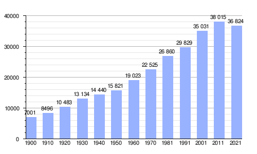 |
Official regular residents according to ISTAC population censuses. |
As of January 1, 2013, Los Realejos had a total of 37,970 inhabitants, ranking 7th in number of inhabitants both on the island of Tenerife and in the province of Santa Cruz de Tenerife.
The relative population was 665.09 inhabitants/km².
By age, there were 69% of people between 15 and 64 years of age, 16% over 65 years of age and 15% between 0 and 14 years of age. By sex, it had 18,724 men and 19,246 women. Regarding the place of birth, 84% of the inhabitants of the municipality were born in the Canary Islands, of which 64% were born in another municipality on the island, 35% in the municipality itself and 1% came from another island. of the archipelago. The rest of the population was made up of 3% of those born in the rest of Spain and 13% of those born abroad, of which 44% were from America and 53% from the rest of Europe.
| Single entity | Inhabitants |
|---|---|
| Cruz Santa Cruz | 4298 |
| Icod the High | 6218 |
| Toscal - Longuera | 6793 |
| Mountain-Zamora | 1041 |
| Palo Blanco-Llanadas | 2842 |
| Los Realejos (municipal capital) | 17 628 |
| TOTAL | 38 820 |
Administration and politics
City Hall
Los Realejos is governed by its town council, made up of the mayor-president of the corporation and thirteen councilors, as well as seven opposition councilors.
| Political party | Number of councilors | ||||||||||||||||
| 1979 | 1983 | 1987 | 1991 | 1995 | 1999 | 2003 | 2007 | 2011 | 2015 | ||||||||
| Independent Royal Panel (ARI) | 3 | ||||||||||||||||
| Innerfeña Group of Independents (ATI) | 3 | ||||||||||||||||
| Independent Neighborhood of Los Realejos (AVIR) | 1 | ||||||||||||||||
| Popular Alliance-PDP-UL Popular Democratic Party | 6 | 2 | |||||||||||||||
| Democratic and Social Centre (CDS) | 4 | 0 | |||||||||||||||
| Coalition Canaria (CC)1 | 6 | 7 | 10 | 9 | 6 | 1 | 1 | ||||||||||
| Instituto Canaria (ICAN) | 1 | ||||||||||||||||
| Izquierda Canaria Unida (ICU) | 3 | ||||||||||||||||
| Izquierda Unida-Por Tenerife (POR TENERIFE) | 1 | ||||||||||||||||
| Izquierda Unida Canaria-Los Verdes (IU-LV) | 1 | 1 | 1 | 0 | 2 | ||||||||||||
| Popular Party (PP) | 3 | 4 | 2 | 6 | 11 | 14 | 15 | ||||||||||
| Spanish Socialist Workers Party (PSOE) | 11 | 15 | 9 | 14 | 10 | 10 | 8 | 6 | 3 | 4 | 5 | ||||||
| Union de Centro Democrático (UCD) | 8 | ||||||||||||||||
| Union of the Canary People (UPC) | 1 | ||||||||||||||||
1Since 2007, it is presented jointly with the Canario Nationalist Party (PNC), and in 2011 also with the Nationalist Canary Center (CCN). | |||||||||||||||||

List of mayors since the 1979 democratic elections
| Mayor. | Start of mandate | End of mandate | Party | ||
| Santiago Luis García | 1979 | 1984 | Spanish Socialist Workers Party (PSOE) | ||
| Jesús Manuel Hernández García | 1984 | 1987 | Spanish Socialist Workers Party (PSOE) | ||
| José Vicente González Hernández | 1987 | 2003 | Spanish Socialist Workers Party (PSOE) | ||
| Oswaldo Amaro Luis | 2003 | 2011 | Coalition Canaria (CC) | ||
| Manuel Domínguez González | 2011 | 2022 | Popular Party (PP) | ||
| Adolfo González | 2022 | current | Popular Party (PP) | ||
Manuel Domínguez resigns as mayor to present himself as President of the Government of the Canary Islands for the Popular Party in the 2023 Canary Islands Parliament Elections
Territorial organization
The municipality is included in the Comarca del Valle de La Orotava, except for its surface immersed in the protected natural spaces of the Teide National Park and the Corona Forestal, which belong to the Comarca del Macizo Central.
The municipal term is divided into six singular population entities, some of them in turn divided into nuclei:
| Single entity | Nucles | Surface |
|---|---|---|
| Cruz Santa Cruz | Cruz Santa Cruz The Charterya | - km2 |
| Icod the High | The Lance The Dornajo Lomo Marquez The Gallinera The Mazapé La Pared Lomo Juan de la Guardia | - km2 |
| Toscal - Longuera | The Toscal The Longuera | - km2 |
| Mountain-Zamora | The Garden The Grimona La Higuerita La Montañeta La Zamora | - km2 |
| Palo Blanco-Llanadas | La Ferruja The Plains Palo Blanco La Romera - Placeres | - km2 |
| Los Realejos (municipal capital) | Realejo Alto
San Benito The Race The Horno Romero Toscas The Mocán | - km2 |
| TOTAL | 57.09 km2 |
Economy
The municipality of Los Realejos stands out for having a more balanced structure by sectors of activity than the provincial or regional average.
Agriculture

5.4% of the municipality's population works in agriculture. This level is higher than the provincial and regional average, whose percentages are 3.7% and 3.5%, respectively.
In the middle areas of the municipality, the most prominent traditional crops are potatoes, grapes, cereals and fruit trees, some of which are developed more than others depending on the area. In Icod el Alto, Palo Blanco and Las Llanadas they are dedicated essentially to the cultivation of cereals such as wheat, millet (corn), rye and the typical bonita potatoes, which have recently received the Protected Designation of Origin (PDO), while in other places in the realejeras, especially in La Cruz Santa and La Piñera, the main crop is grapes, from which white wine is made.
Likewise, the low-lying or coastal areas have been used for export crops, mainly bananas and tropical fruit trees such as avocados, and cut flowers in some areas such as San Vicente.
Livestock in the municipality is mainly goats, while pigs, cattle and horses exist in smaller quantities.
Services
Regarding the services sector, the percentage of people affiliated with this sector of activity is 60%, well below the provincial and regional average, these being 75.8% and 76.5%, respectively. Most of the citizens who work in this sector do so in other neighboring municipalities such as Puerto de la Cruz.
Although Los Realejos is not a tourist city, it is one of the municipalities in the Canary Islands with the largest number of rural hotels.
Social welfare
Education
Public schools
- CEIP Pérez Zamora
- CEIP San Sebastián
- CEIP Agustín Espinosa
- CEIP Toscal - Longuera
- CEIP La Montañeta
- CEIP Mencey Bentor
- CEIP La Pared
- CEIP White stick
- IES Realejos
- IES Mencey Bencomo
- IES Cruz Santa
Private teaching centers
- College Nazareth
- Colegio Pureza de María
- British School Tenerife
Health
Public health centers
- Centro Médico Realejos
- Medical Centre Icod el Alto
- Centro Médico Toscal Longuera
- Centro Médico La Cruz Santa
- Palo Blanco Medical Center
- La Montañeta Medical Center
Private health centers
- Medical Center Life
Citizen security
- Local police
- Civil protection
- Volunteer firefighters
Libraries
- Municipal Library Viera and Clavijo
- Peripheral Library Palo Blanco
- Peripheral library Icod el Alto
- Toscal Longuera
Communications
Roads
The municipality is accessed mainly by the Autopista del Norte TF-5. Other roads that are in the municipal area and that connect it with other areas are:
- TF-316 from La Gorvorana to Puerto de la Cruz
- TF-320 from San Nicolás to La Zamora
- TF-324 from La Orotava to Los Realejos
- TF-326 de Cruz Santa a Benijos por Palo Blanco
- TF-333 branch of TF-5 to Los Realejos by La Montañeta
- TF-334 of Los Barros to Saint Vincent by Saint Augustine
- TF-335 from TF-320 (La Zamora) to Los Realejos
- TF-342 from Los Realejos to Icod by La Guancha
- TF-344 from Icod el Alto to La Guancha
Public transport
The municipality has several taxi ranks, and is also connected by bus —bus— by the following TITSA lines:
| Line | Traject. | Tour |
|---|---|---|
| 106 | Santa Cruz - Icod de los Vinos (exprés) | Time/Line |
| 107 | Santa Cruz - Buenavista (by North Airport) | Time/Line |
| 108 | Santa Cruz - Icod de los Vinos (by North Airport) | Time/Line |
| 325 | Puerto de la Cruz - Acantilados de Los Gigantes (by Icod de los Vinos) | Time/Line |
| 330 | Los Realejos - San Vicente - Las Llanadas (circunvalation) | Time/Line |
| 339 | Puerto de la Cruz - Realejo Alto (circunvalation) | Time/Line |
| 347 | La Orotava - Realejo Alto (by Benijos and Palo Blanco) | Time/Line |
| 353 | Circumvalación Valle de La Orotava - Realejo Bajo y Las Dehesas | Time/Line |
| 354 | Puerto de la Cruz - Icod de los Vinos (by La Guancha) | Time/Line |
| 381 | Plaza Reyes Católicos - Punta Brava (by Loro Parque) - Toscal - Longuera | Time/Line |
| 390 | Puerto de la Cruz - Realejo Alto (by Mountain) | Time/Line |
| 391 | Puerto de la Cruz - Realejo Alto (by San Agustín) | Time/Line |
Heritage

The municipality has several heritage elements declared of Cultural Interest:
- Historical Sets
- Realejo Bajo (Bien de Interés Cultural en la categoría de conjunto histórico).
- Realejo Alto (Good for Cultural Interest in the category of historical group).
- Plaza de San Agustín (Los Realejos) and its surroundings (Bien de Interés Cultural).
- Religious Architecture


- Church of Santiago Apostle, Realejo Alto, xv-xvii centuries (Good of Cultural Interest).
- Ntra Church. Mrs. de la Concepción, Realejo Bajo, Centuries xvi-xvii (BIC).
- Sanctuary of Ntra. Sra. del Carmen, San Agustín, sigloXX. (BIC).
- Church of the Holy Cross, La Cruz Santa, centuryXVIII.
- Ntra Church. Sra. del Buen Viaje, Icod el alto, sigloXVIII.
- Ntra Church. Sra. de los Dolores, Palo Blanco, sigloXVIII.
- Ntra Church. Sra. de las Nieves, La Zamora, sigloXX..
- Ntra Church. Sra. de Guadalupe, Toscal - Longuera, sigloXX..
- Church of San Cayetano, La Montañeta, XVIII-X.
- Ntra hermit. Sra. del Socorro, Rambla del Mar, sigloXVII.
- Ntra hermit. Sra. de la Concecpión, Tigaiga, sigloXVII.
- Chapel of San Benito, Realejo Alto, centuryXVII.
- Chapel of San Juan, El Lance, Icod el Alto, centuryXVII.
- Chapel of San Pedro, Rambla de Castro, centuryXVII.
- Chapel of San Sebastian, Realejo Bajo, centuryXVIII.
- Chapel of Saint Vincent, centuryXVII.
- Ntra hermit. Sra. de Guadalupe La Gorvorana, Toscal - Longuera, sigloXVIII.
- Chapel of San Joaquín and Santa Ana, The Garden.
- Hermit Ntra. Mrs. de Los Remedios. El Horno, centuryXX..
- Cross Chapel, Palo Blanco.
- San Martín de Porres Chapel, La Romera.
- Chapel of the Santa Cruz de La Sombrera, Tanque Arriba.
- Chapel of Santa Cruz and Santa Marta, Las Toscas de Romero.
- Santa Cruz Chapel, El Horno.
- Ntra Chapel. Ms. from La Candelaria, La Piñera.
- Ntra Chapel. Mrs. de la Milagrosa, La Ferruja.
- Chapel of the Holy Cross, San Antonio Abad and Santa María de la Cruz, Cruz del Castaño.
- Chapel of the Cross of El Sol Street, Realejo Alto.
- Chapel of the Cross of El Medio Arriba Street, Realejo Alto.
- Chapel of the Cross of the Peral, Realejo Alto.
- Cedrés Family Cross Chapel, El Medio Arriba Street, Realejo Alto.
- Capilla de la Cruz Verde, Realejo Bajo.
- Crown Cross Chapel, Icod el Alto.
- Cross Chapel, La Carrera.
- Chapel of the Cross, Toscas de San Agustín.
- Cantillo Cross Chapel, Bajo Realejo.
- Capilla de la Cruz de Márquez, Realejo Bajo.
- Cross Chapel, La Callita.
- Chapel of the Cross of the Sawmill, Tigaiga.
- La Hoyada Cross Chapel, Tigaiga.
- Place of the cruises of the rails, El Lance, Icod el Alto.
- Capilla de la Cruz del Marquis, Hoya Pablo - Las Llanadas.
- Chapel of the Cross, La Piñera.
- Chapel of the Bravo Cross, La Ferruja.
- Chapel of the Cross, La Cartaya.
- Chapel of the Cross, El Natero, La Cruz Santa.
- Chapel of the Patio Cross, The Garden.
- Chapel of the Cross House Higa, La Cruz Santa.
- Chapel De la Cruz de la Pared, Icod el Alto.
- Chapel of the Cross of the Lomo, La Cruz Santa.
- Chapel of the Cross Los Herreros, La Cruz Santa.
- Capillas de las Cruces de La Punta, La Cruz Santa.
- Chapel of the Cross, Pico la Montañeta.
- Chapel of the Cross, El Toscal.
- Chapel of the Cross (House of the poet Antonio Reyes) El Dornajo, Icod El Alto.
- Treasury
- Hacienda de Los Príncipes, XV-XVI (BIC).
- Hacienda de Castro or del Mayorazgo, centuryXVI.
- Hacienda las Canales o Jardines de Castro, centuryXVI.
- Hacienda del Cuchillo, centuryXVI.
- Hacienda de la Choza, centuryXVI.
- Hacienda el Patronato, centuryXVI.
- Hacienda el Terrero, centuryXVI.
- Hacienda La Gorvorana, xvi-xvii centuries.
- Hacienda la Pared, centuryXVII.
- Hacienda de La Coronela, centuryXVII.
- Hacienda de San Antonio, centuryXVII.
- Hacienda la Era, centuryXVII.
- Hacienda el Socorro, centuryXVII.
- Hacienda del Vizconde de Buen Paso, centuryXVII.
- Hacienda La Calderona, centuryXVII.
- Hacienda de Las Cuatro Ventanas, centuryXVII.
- Hacienda El Drago de Seven Fuentes, centuryXVII.
- Hacienda San Ildefonso, centuryXVIII.
- Hacienda de Los Poggio, centuryXVIII.
- Hacienda La Gallera or Casa La Fajana, centuryXVIII.
- Hacienda la Torre, xviii-xix centuries.
- Hacienda el Patio, centuryXIX.
- Hacienda Salazar or Finca Zamora, centuryXX..
- Hacienda Los Afligidos.
- Hacienda de Los Cuartos.
- Hacienda de los Pires or the Barros.
- Hacienda La Piñera.
- Houses

- Casa Parroquial La Cruz Santa.
- Casa Parroquial Icod el Alto.
- Casa de las Religiosas de la Sangrada Familia de Nazaret.
- Casa Natal de José de Viera y Clavijo, centuryXVII.
- Casa de la Parra Baja, centuryXVII.
- Casa Parroquial Realejo Alto, centuryXVII.
- Casa Parroquial Realejo Bajo, centuryXVII.
- Casa Natal de Agustín Espinosa García Estrada, centuryXX..
- Casa Natal de Antonio González González, Calle El Sol.
- Industrial Architecture
- Elevador de agua de La Gordejuela, built in 1903 and in whose interior the first steam engine of Tenerife was installed.
- Molinos de gofio de la Hacienda de Los Príncipes, in Realejo Bajo, centuryXVI.
- Molino de gofio, La Treviña (Palo Blanco). First electrical plant in the municipality, 1930.
- Pesadero de Agua, La Pasada de La Carreta (La Romera). Dated in 1914, they are of the few buildings related to the use of the waters that are preserved in the municipality.
- Abrevadero, Calle El Medio Arriba, centuryXVIII.
- Washing machines, Barranco La Lora. centuryXVIII - XIX.
- Washing machines, Barranco de Romero. CenturyXIX. (Pending to rebuild the main cube).
- Military Architecture:
- Fortín de San Fernando, centuryXVIII.
- Historicist Architecture:
- The Castle, the Barros, centuryXIX.
Likewise, Los Realejos has some archaeological sites of the Guanche culture.
Culture
Parties

The municipality of Los Realejos has almost a hundred festivities a year, which makes it the town with the most festivities in Spain, being local holidays January 22, the festival of San Vicente and on May 3 exaltation of the Holy Cross.
Some of the most notable festivals are:
- San Vicente Mártir: co-sponsor of the Villa along with Santiago Apostle, and patron of the former municipality of Realejo Bajo, is celebrated on January 22.
- Carnivals: in which it is worth highlighting seven typical groups of these parties that are the murgas: Trapaseros, Archicuerpos, Irónicos, Picaronas, Trapaseritos, Archicuerpitos y Menudos Irónicos.
- Holy Week: highlighting among the imagery that in those days it draws the image of El Nazareno (Los Realejos) in procession.

- Feasts of the Cross (3 May): declared Festival of Tourist Interest of the Canary Islands. On the 2nd of May the crossings in Los Realejos, especially in the neighborhood of La Cruz Santa, are rooted. On the night of the following day, in the Realejo Alto, the streets of the Middle and the Sun compete with each other with a fireworks show during the procession of La Cruz, giving rise to one of the largest pirotechnic exhibitions in Europe. This festival in honor of the Santa Cruz dates back to the years following the foundation of the municipality at the end of the centuryXV and principles of the XVI, in which the bishop of Diego de Muros orders and promotes the celebration of the Exaltation of the Holy Cross every 3 May. In addition, the founding of the Franciscan convent of Saint Lucia (S. XVII) in the Royal Alto favors and promotes this festival by the great evangelization of the Franciscans and by the custom of the friars to place on the roads wooden crosses.
- Romería Regional de San Isidro Labrador y Santa María de La Cabeza (last Sunday of May): inside the festivals of May, which in Los Realejos are held in honor of La Santa Cruz, San Isidro Labrador, Santa María de la Cabeza and Monday of Remedios Monday following the Romeria, coinciding with the last Sunday of the month of May, takes place the Romeria de San Isidro Labrador In it, the population looks at the typical and traditional costumes of the island, with which it boasts of the folk tradition of Los Realejos, and accompany the images of San Isidro Labrador and Santa María de la Cabeza. This romeria has been celebrated uninterrupted since the year 1676, in which the image of St.Isidro Labrador was enthroned at the main altar of the church of James the Apostle, relegating to a background the image of St.Benedict Abad, with which a pilgrimage was also celebrated. Thus, the image of San Isidro Labrador de Los Realejos constitutes the oldest iconographic representation of this saint that is preserved in the Canary Islands, and its pilgrimage in the oldest in honor of him on the island.
- Corpus Christi: celebrated in all the churches of the municipality, where it is worth highlighting the tapestries made in the historical quarter of the Realejo Bajo and La Cruz Santa, as well as in the Realejo Alto, and the arches adorned with biblical and Eucharistic scenes in the town of Toscal - Longuera.
- St Peter the Apostle: in which it is worth highlighting the ornaments with precious arches of fruits at the entrance of his hermitage. It is held on 29 June.
- Our Lady of Carmen: in honor of the Mayor Perpetua of the municipality and Patrona of the Valley of La Orotava (for the whole month of July).
- Santiago Apostle: co-sponsor of the Villa along with San Vicente, and patron of the former municipality of Realejo Alto, is held on 25 July.
- Our Lady of the Rosary (in early or mid-October)
- Our Lady of the Religious (at the end of August)
- Immaculate Conception (December): on the 5th, the descent of the virgin of the altar, by a rail system.
- Romería de San António abad: around the second week of January, neighborhood of Tigaiga.
- San Sebastián Mártir: towards the penultimate week of January, Realejo Bajo.
- Santa Cruz del Peral: May 2. Gonídez-Calle Viera and Clavijo.
- Santa Cruz del Pico, La Montañeta del Fraile, La Montañeta: May 3.
- Santa Cruz de La Calle del Medio: May 3 (Pyrotechnic Exhibition).
- Santa Cruz de La Calle del Sol: May 3 (Pyrotechnic Exhibition).
- Santa Cruz del Castaño: May 3,Cruz del Castaño
- Santa Cruz de La Carrera: around the second week of May, La Carrera.
- Santa Cruz de La Higuerita: Last Sunday of June, La Higuerita.
- San António de Padua: second week of June, Palo Blanco.
- Santa Cruz de La Sombrera and San Juan Bautista: around June 24.
- Santa Cruz de La Corona and San Juan Bautista: towards 24 June. Natural landscape of the Crown.
- Santa Cruz de Las Toscas de Romero and Santa Marta: days around the 29th of July.
- Our Lady of Palo Blanco (Under the advocation of Los Dolores): first Sunday of August, Palo Blanco.
- San Cayetano: August 7, first week of August, La Montañeta district.
- Ntra. Mrs. de Candelaria: August 15, La Piñera.
- Ntra. Mrs. de Las Nieves: towards the second week of August, La Zamora-Grimona.
- Miraculous Virgin: the third Sunday of August, Camino Across-La Ferruja.
- Ntra. Mrs. del Buen Viaje: last Sunday of August, Icod el Alto.
- Santa Cruz del Jardín: last week of August, neighborhood of the Garden.
- Santa Cruz del Mocán: first Sunday of September, Mocán neighborhood.
- San Antonio Abad and Santa María de la Cruz: first Sunday of September, Las Llanadas-Cruz del Castaño.
- Santa Cruz and Ntra. Mrs. de Los Remedios: second Sunday of September. The Horn.
- Immaculate Conception: first Sunday of September, Tigaiga.
- Santa Cruz and Our Lady of Los Remedios: second Sunday of September, El Horno.
- Ntra. Sra. de Guadalupe: around the second week of September, 12 de diciembre. barrio Toscal-Longuera.
- Ntra. Sra. de Las Mercedes: día 24 de septiembre, La Cruz Santa.
- San Francisco de Assisi: first week of October, San Francisco Barriada (Realejo Bajo).
- San Martín de Porres: day 3 of November and weekend later, La Romera and Placeres.
Sports
Paragliding is one of the sports that take place in the municipality. At the beginning of May, coinciding with the celebration of the Los Realejos International Paragliding Festival, FLYPA, the world's best paragliding, paramotoring, skydiving and base jumping pilots land on El Socorro beach, gathering thousands of people every day.
Los Realejos is home to the highest orographic step that a hiker can face on a Spanish summit. This is the 0-4-0 Route, which starts from Socorro beach and, after crossing several neighborhoods of the municipality and entering the National Park, ends at the very peak of Teide. This route is almost 4 kilometers vertical from sea level and 7 from its marine base, with about 7,600 meters of accumulated unevenness up and down over 58 kilometers of mountainous route.
Several surfing and bodyboarding championships are held annually on the beach of El Socorro in their different categories. July, August and September are usually the months chosen for these national, European or world competitions. Among them, the Canary Islands championship, the O'Neill test and the "La Santa Pro Junior" world surfing test, which take place every year in Los Realejos, stand out.
For lovers of sport fishing and scuba diving, the area of the natural pools of Guindaste, El Ingenio and Los Roques are favorable for practicing these sports, which also have a large number of followers.
- Featured athletes
- Pedro Mario Álvarez Abrante, footballer of FK Bakú.
- Ricardo León Brito, footballer at the Club Deportivo Tenerife.
- Ivan Rodríguez Ramallo, athlete eight times Spanish champion of the Club Atletismo Tenerife CajaCanarias.
- Yeray González Luis, footballer at the Sports Club Tenerife.
Religion
The majority of the believing population of the municipality professes the Catholic religion, the parishioners being divided into ten parishes belonging to the archpriesthood of La Orotava in the diocese of Tenerife:
- Parish matrix of Santiago Apostle, in Realejo Alto
- Parish of Our Lady of Guadalupe, in the Toscal - Longuera.
- Ntra Parish. Sra. de la Concepción, en Realejo Bajo
- Ntra Parish. Sra. de las Nieves, en La Grimona
- Ntra Parish. Sra. de los Dolores, en Palo Blanco
- Ntra Parish. Sra. del Buen Viaje, en Icod el Alto
- Ntra Parish. Sra. del Carmen, en San Agustín
- San Cayetano Parish in La Montañeta
- Parish of San Joaquín and Santa Ana in El Jardin
- Parish of the Holy Cross in La Cruz Santa
Places of interest
- Playa de El Burgado
- Playa de Castro
- Playa de la Fajana
- Playa de El Socorro, Bandera Azul since 1999
- Playa de Los Roques
- Natural pools of El Guindaste
- Aula de la Naturaleza Emilio Fernández Muñoz


The municipality has different viewpoints that are found throughout its geography. On the Tigaiga slope is the La Corona viewpoint, located in the Icod el Alto neighborhood and from where you can see the La Orotava Valley and the entire northeast of the island. It is also a place for lovers of adventure sports such as paragliding, free flight or hiking.
On the access road to the center of Icod el Alto is the El Lance viewpoint, which offers another impressive view of the three municipalities that make up the Valley, and where you can admire a bronze sculpture of the mencey Bentor, a Guanche king who chose this location to commit suicide by throwing himself into the void, thus preferring to die rather than be enslaved by the Castilian troops at the end of the conquest of the island.
On the coast, near the San Vicente neighborhood, is the San Pedro viewpoint, from where you can see the palm grove of La Rambla de Castro and the banana plantations of Rambla del Mar, which surround haciendas.
On the Northern highway, towards Icod de los Vinos, is the viewpoint of La Grimona, from where you can see the beach of the same name, the coast of El Socorro and Punta del Guindaste.
Los Realejos has four recreation areas in nature. In the upper area of the neighborhoods of Palo Blanco and Las Llanadas, on the natural border between the tree formations of fayal-brezal and pine forest, is the recreational area of Chanajiga, which many trails arrive at and leave from. that allow the walker to descend to the coast or ascend to the highest peaks of the island.
On one side of the Orotava-Icod de los Vinos highway are the recreational areas of La Higuerita and Barranco de Ruíz, the latter on the border with the municipality of San Juan de la Rambla and located It is located in the final section of this ravine, declared a site of scientific interest. In addition, from here trails start along the coast or through the ravine itself.
Twinnings
 Cabaiguán (1992)
 El Realejo de Granada (9 October 1992)
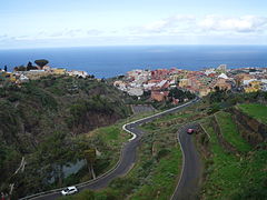
Gallery
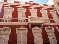
Facade Casa Colonial

Mirador de San Pedro

Charco del Guindaste

La Gordejuela Water Lift

Trail on the Rambla de Castro

Playa de Socorro

Plaza Realejo Bajo

Houses in San Agustín
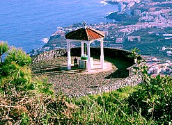
Crown viewer

Realejo Alto
San Agustín from the Realejo Alto


Contenido relacionado
Puerto Serrano
Swamp
Ratchet