The iron
El Hierro is the westernmost and southernmost of the Canary Islands (Spain), located in the Atlantic Ocean. It belongs to the province of Santa Cruz de Tenerife. Its capital is Valverde, where, apart from La Villa (urban area), the Port of La Estaca and the insular airport are also located. In addition to Valverde, El Hierro has two other municipalities: La Frontera and El Pinar. El Hierro has a population of 11,423 inhabitants for 2022, making it the second least populated of the eight islands; It is also the one that, with 268.71 km², has the smallest surface area among the seven largest islands.
On January 22, 2000, it was declared a Biosphere Reserve by Unesco. A plan promoted by the Ministry of Industry, Energy and Tourism is currently being developed to make it the first island in the world to be fully supplied with renewable energy. On June 27, 2014, the Gorona del Wind, with which this objective is achieved, although this statement is questioned by some. In 2014 the entire island was declared a geopark by Unesco.
Toponymy
There are several hypotheses about the etymology of "El Hierro". It seems that the name comes from the horseshoe shape of El Golfo, although other explanations have also been suggested.
According to the work by Pliny the Elder called Naturalis historia, the island of El Hierro was known by the Romans as Capraria., they knew it as Eseró or Heró, which has been translated as "rocky wall".
Description
Geography
It is crossed from west to east by a large ridge-shaped line with numerous mountains. The coastal areas are made up of badlands, with steep cliffs.
With these conditions it is difficult to find sandy beaches, which are usually coves with difficult access. Instead, the inlets of the sea and natural pools are often used as bathing and leisure areas (La Maceta in Frontera, the Pozo de Las Calcosas on the coast of El Mocanal, or Tacorón, near La Restinga).
El Hierro is the smallest, southern and western island of the Canary archipelago. It has an area of 268.71 km² and a population of 11,423 inhabitants (INE, 2022).
The maximum height is located in the center of the island, at the Malpaso peak, with an altitude of 1,501 m, followed by the Tenerife peak at 1,253 m. Among other geographical accidents, the Valley of the Gulf stands out, produced after the landslide of a part of the island. It is also worth noting the tip of La Restinga (the southernmost point of Spain) and the tip of La Orchilla (the westernmost point of Spain). In proportion to its size, it is the island with the largest area of protected natural spaces in the entire archipelago (58% of its territory), according to the Canary Islands Network of Protected Natural Spaces.
The islets called Roques de Salmor (Roque Grande and Roque Chico) also belong to El Hierro, with an area of 0.03 km², which make up an integral nature reserve.
Population
The island has a population in 2020 of 11,147 inhabitants, according to the Canary Islands Institute of Statistics (ISTAC). It is the seventh largest island in the Canary Islands in terms of population, and therefore the second least populated in the archipelago, ahead of La Graciosa.
Throughout history it has suffered a demographic decline due to economic hardships and prolonged droughts. This trend has been reversed in recent years, largely thanks to the return of many emigrants who had settled in Venezuela. Its inhabitants receive the name of herreños.
In 2010, the census of El Hierro presented the following figures:
- Valverde: 5035
- La Frontera: 4124
- The Pain of The Iron: 1801
- Percentage of total Canary Islands: 0.5 %
Religion
The majority of the island's population professes the Catholic religion as in the rest of the Canary Islands and Spain, although there are also minorities of other religions. The island forms an archpriesthood belonging to the Diocese of San Cristóbal de La Laguna, the Arciprestazgo de El Hierro.
The island is under the patronage of the Virgen de los Reyes and San Agustín de Hipona. An insular holiday on the island is September 24, the feast of the Virgen de los Reyes.
History
It has traditionally been known as "Meridian Island" or "Isla del Meridiano Cero". Ptolemy is credited with having located the Origin Meridian, at the western end of the sea known at his time, in the Canary Islands. From 1884 Greenwich was established as the new origin meridian, as an imposition of British power.
Pre-Hispanic period
The island was originally populated by the Bimbache people, genetically and culturally related to the Berbers of North Africa.
The economy of the bimbaches was mainly pastoral, with abundant goats, sheep and pigs. They were also engaged in agriculture (at least barley), harvesting and the use of marine resources. In El Hierro, as was also the case in Lanzarote, there was no internal territorial division, unlike in the rest of the islands. The conquest took place at the end of 1405 by Jean de Bethencourt. There was no resistance from the small aboriginal population, whom he promised to respect in freedom; However, the conquered ended up selling the majority as slaves, and the island was repopulated with Normans and Castilians.
The Crown of Castile on the island
The Crown of Castile paid Basque-French mercenaries to conquer the island; however, they sold it to Portugal, which later ceded it to the Spanish Crown in the Treaty of Alcazobas. Before the arrival of the troops of the Castilian and Aragonese crowns, the population was pastoral with goats, sheep and pigs and developed the cultivation of cereals, in addition to exploiting plant and marine resources. Because there was no trade route, manufactured goods and tools were in short supply. There was only an internal market. Supposedly, land and other common resources were divided equally. Divine power was represented by nature. The progressive expansion of control by the Crown of Castile concentrated the land and the benefits of commercial production, through a stately regime. Before and after the island was incorporated into the Spanish Crown, some inhabitants were taken as slave labor; although they later returned to the island. Later, French and Galicians settled under the stately regime.
Visit from Columbus
On his second voyage to America, Christopher Columbus stopped at La Gomera and El Hierro. On this last island he made the stopover to provide himself with food and water as well as to wait for better winds. In total, he spent 17 days on the island waiting for an improvement in the trade winds that would allow his fleet of 17 ships to move faster. On October 3, 1493, he left the Bay of Naos for the New World.
Church of the Conception
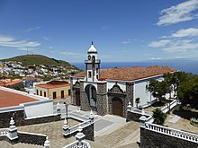
In the Villa de Valverde is the Iglesia Matriz de Nuestra Señora de la Concepción, in the classicist Baroque style, built between 1767 and 1820. The temple has a rectangular floor plan, divided into three naves. The bell tower is located in the central nave and at its head we find a square apse.
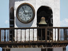
On the main façade, the central nave is advanced and a large semicircular arch made of stonework opens on it, on top of which rises an original tower, whose second body is made up of an octagonal bell tower, topped by a small dome of Mudejar influence, with an image of the Virgin of La Concepción.
Some pillars support the roof of the church, inside which it is possible to see a coffered ceiling made of pine wood, in a very simple Mudejar style. This roof was reformed in 1937, since the previous one threatened ruin. The main chapel and the transept maintain the original roof.
Emigration
Part of the island's inhabitants were forced to emigrate throughout history, due to limited farmland and long droughts. The greatest recent emigration was due to the drought of the mid-XX century. Many people from El Hierro emigrated to Tenerife or Gran Canaria. Sailing boats also left from El Hierro to South America, clandestinely, forming Canarian colonies, mostly of merchants of agricultural products. In part they returned to the Canary Islands, although others -and their descendants- are inhabitants of different countries in America.
Banishment
The 19th century meant that El Hierro, like Fuerteventura, became interesting as a place of deportation for some politicians, disgraced military and liberals. The population was in charge of monitoring the deportees. Although the island became a kind of prison far away, it was beneficial for the islanders. Thanks to this, Leandro Pérez was deported from Tenerife in 1823, for political reasons, becoming the first doctor on the island, verifying the curative properties of the waters of the Pozo de Sabinosa, or Pozo de la Salud, which while confined in El Hierro, was sentenced to death, but managed to save himself because the people of El Hierro helped him flee to America.
Other inmates were Félix Mejía, editor of the popular satirical weekly El Zurriago, as well as other exasperated journalists angry with Father Blas de Ostolaza, formerly an educator of Fernando VII, accused of degenerate corrupting minors, who managed to escape on a North American ship with the help of the Canarian community organization and the international coal company, arriving in Philadelphia in 1824 in the midst of absolute misery. Mejía received the protection of American liberals, Freemasons and Bonapartists exiled there, including José Bonaparte.
In the XX century, when Alejandro Lerroux governed in the Second Republic, the communist leader Florencio Sosa Acevedo, deputy, was exiled, teacher and mayor of Puerto de la Cruz, although for a few months, because in the elections of February 16, 1936 he won the act of deputy to Cortes for Santa Cruz de Tenerife.
Confined for about six months during 1962 were Íñigo Cavero and José Luis Ruiz-Navarro, professors at the Complutense University of Madrid, retaliated for their attendance in Munich at the Congress of the European Movement. With the Transition, in 1977, by the UCD, José Luis Ruiz-Navarro was elected deputy to Cortes, and Iñigo Cavero Minister of Justice and Culture, who felt so grateful for the treatment of the people from El Hierro, that 18 years later he attended some parties in El Hierro.
Well of Health
Between 1702 and 1704, the Pozo de la Salud, which was initially called Pozo de Sabinosa, was drilled. It was part of a systematic search for drinking water along the line of the coast. The water found was somewhat brackish, but very useful for watering the animals. But, in addition, it was soon found that the people who drank that water had better health and resisted epidemics.
Throughout the XIX century, numerous doctors certified its properties. Famous personalities also drank its waters, according to the traditional method. Each day of therapy in the Well began by drinking several liters of freshly extracted water, until obtaining a purgative effect. Later it was necessary to take a bath in very hot water (45 °C), for about 10 minutes. And then to sweat in bed, very warm.
The water from the Well of Health was used to improve or cure many skin diseases and digestive disorders. But the list of his indications was broader. Thanks to his fame, the pilgrimage of patients who came from other islands was constant. The main reason for traveling to the island of El Hierro was to drink the mineral-medicinal waters of the Pozo de la Salud.
In the XX century, in the decades of the forties and fifties, the famous singer i> and drummer Valentina la de Sabinosa and her husband Esdras prepared the hot baths. The best reference for anecdotes about her stay is found in the book by humorist Jacinto del Rosario: Estrambotic Journey to the Well of Health , published in 1950.
At that time the engineer José Rodrigo-Vallabriga built the initial spa, and marketed the water for sale in pharmacies and stores. Mr. Vallabriga lived in Santa Cruz de Tenerife, in Plaza de la Iglesia No. 11 (old), and on the ground floor of his house he established a small bottling industry. To do this, he first transported the water in jugs from El Hierro. And once transferred to glass bottles, he distributed it throughout the islands.
Until 1965, the year of the death of the engineer Vallabriga, the Pozo de la Salud had a certain artistic animation, since its waters were drunk by musicians and poets, in successive summers. And in moments of rest gatherings were improvised.
In the 1970s and early 1980s, Doña Rosa ran the baths in her establishment Casa Rosa. The atmosphere was familiar there. Doña Rosa was the last great enthusiast of those waters.
Shortly thereafter, the El Hierro Council began construction of the modern Pozo de la Salud Hotel-Spa. In 2010 the hotel was closed for renovations. At the end of 2011, the hotel reopened to provide beauty and relaxation treatments, in addition to serving as quality accommodation, in an environment of great natural beauty.
20th and 21st centuries
In July 1899, a fire swept through the Valverde town hall, destroying the archive that had been created in 1553. Important documents on the history of the island were burned. Also at this time there was an epidemic of smallpox and a long drought, followed by very rainy years with frequent floods.
In 1912 the municipalities of Valverde and Frontera were created. With the creation of the Island Councils, the island acquired self-government. The First World War did not bring any special change to the island. In the following decades, the Port of La Estaca was built, roads and water pipes were improved and schools were built. The Second World War, unlike on the other islands, did not make itself felt on El Hierro either. In 1948 another long drought caused the emigration of part of the population to Venezuela and the island of Tenerife.
Microsatellite launcher and military radar
In the 1990s, INTA thought of creating a microsatellite launch station, to send two research satellites a year, for a total of fifteen. For security reasons, the nearby towns should have been evacuated, which is why a demonstration was held with several thousand attendees in Tenerife, many of them transferred from El Hierro by boat, as even public institutions offered free tickets. In February 1997, the majority of the Parliament of the Canary Islands rejected the project; although shortly after the corded lavas of the "protected area" of Tacorón to plant tropical fruits.
The second project, to install a military radar on the peak of Malpaso, is still pending. The geographical situation of the island is an incentive for its installation. Since 1986 there have been protests by the locals, the year in which the Ministry of Defense communicated its plans to the Frontera town hall. In June 2005, the then Defense Minister, José Bono, announced that it could be a mobile radar that would not affect the orography of the area.
Volcanic activity in 2011 and 2012
As of July 19, 2011, a large number of earthquakes began to be felt on the island, which attracted the attention of numerous specialists. As the intensity and frequency of the earthquakes increased, the population was alerted to a possible eruption. The first eruption observed by indirect means was perceived in the sea, 5 kilometers from the island, on October 10, 2011.
In March 2012, the submarine eruption in the Mar de las Calmas ended. According to data from the Spanish Institute of Oceanography, the crater of the extinct volcano is 88 meters deep.
Nature
Climate
The orography conditions the climate of each area of the island. However, it is the clouds that play the most important role in climate variations. The trade winds and the Canary Current, a cold fork of the Gulf Stream that separates in the Azores, mean that the island does not have an arid climate as occurs in the Sahara located in the same latitude. The water temperature is kept at 18 °C in winter and 20 °C in summer. This softens coastal temperatures. At the equator there is a massive rise of hot air, creating a zone of low pressure that is occupied by another mass of air provided by the trade winds. The hot air masses that rise gradually cool down and head high up in the opposite direction to the Trade Winds, towards the subtropical latitudes, where they come from. The trade winds transport clouds loaded with water towards the peaks of El Hierro, where showers are generated. The southern part of the island receives dry and cloudless winds, so the temperature and aridity is higher in that part.
In summer, the temperature on the north coast is 26 °C on average, while the average temperature is 30 °C in the south. Valverde, which is 600 m above sea level, has an average summer temperature of 18 °C. In winter, the average temperature on the north coast is 20 °C while on the south it is 21.5 °C. In Valverde, however, the average drops to 11.5 °C. Winter rainfall in Valverde amounts to 80 mm per month, while in the south only 25 mm per month. In summer, it hardly rains in the south, but in Valverde it registers 5 mm per month.
Geology
Island Formation
El Hierro, like the rest of the Canaries, is an island of volcanic origin. A geological age of one million years is estimated, making it the youngest Canary Island. When the magma broke the seabed, a "Y"-shaped gap could be created, through which lava began to flow. The most active phase of the formation of the island is located around 10,000 BC. C. The youngest eruptions lasted from 4000 B.C. C. until 1000.
The island took the shape of a "Y". The lava flows covered the southern and western coastal areas of the island, but also the northern area. The different eruptions were expanding the size of the island. Large landslides of unstable volcanic material could also occur.
In 1793, according to the chronicles, there was a series of seismic phenomena in the El Verodal area, although none of the documents of the time recorded an eruption. Hernández Pacheco (1982) carried out a vulcanological study locating the possible eruption in the Lomo Negro volcano. However, other authors (Romero, 1991) question this eruption, and it is not yet scientifically confirmed.
El Hierro is the island with the highest density of volcanoes in the Canary Islands, with more than 500 open-air craters and another 300 covered by more recent lava flows. There are currently 70 cataloged caves and volcanic tubes, highlighting the Cueva de Don Justo, 6 km long. It is made up of a system of volcanic tubes formed by the cooling of lava flows outside. The hot lava inside the tube continued to flow until it was empty.
In 2011 there was an underwater eruption that gave rise to the formation of an underwater volcano, the Tagoro volcano, more than 300 meters high above the seabed and whose summit was 89 meters below the sea surface.
Geologic Regions
Unlike the rest of the islands, the north of El Hierro has few ravines. In the central part of the island is the summit, where the peaks of the highest volcanoes are located. Three different geographical regions can be distinguished: the plateau, the El Golfo Valley and the sloping area of El Julan. El Hierro is very mountainous, considering its area. The highest peak is the Pico de Malpaso with 1500 m above sea level. About 90% of the coastal zone is cliffs.
Formation of the Las Playas amphitheater
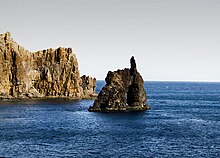
The Las Playas amphitheater is one of the large landslides on the island of El Hierro, conditioned by areas of weakness or ridges (rifts), but which has also been increasing thanks to rain erosion. In this escape you can see the oldest material on the island, the Tiñor building, going through the different stages of the island's formation, easily recognizable thanks to the cut that caused the aforementioned avalanche. The Tiñor building occupies the lower and middle part, crossed by a large number of dikes (feeding paths of the eruptive systems, normally in the form of a table), which are recognizable for being clearer than the rest of the interior of the mountain. In the visible layers, the reddish stripes stand out, known as red ocher, an indicator of a long stage and without eruptions for a long time. A lighter material also stands out, the trachytes, which belong to the El Golfo volcanic edifice. In the lower part of the natural amphitheater, attached to the volcanic buildings, you can see piedmont deposits, which are cones of loose material that comes from the mountains and are deposited at the foot of the mountain and have a characteristic triangular shape. There is also, to the left of the depression on the coast, the Roque de La Bonanza, which although it may not seem like it, is also a volcanic dam, only thanks to the erosion of the sea waves it has turned out to have that characteristic shape, which has been the subject of many autochthonous myths.
Formation of the El Golfo Valley
The Valley of El Golfo was created during the middle period of eruptions. Contrary to ancient belief, it is not a giant ancient crater, the other half of which is submerged, but a process of erosion and landslides. Several studies carried out on the seabed have shown that the valley was created by a landslide of the terrain, which generated a great tsunami. The force of gravity dragged the materials, leaving the walls of the current valley, made of older and more resistant materials, in their current position.
Flora
El Hierro has different areas of vegetation, from desert lava fields to laurel forests, passing through pine forests, pastures and banana plantations.
Despite the fact that El Hierro is in the area of influence of the trade winds, the vegetation is not as lush as on the neighboring islands of La Palma, Tenerife and La Gomera. The reason for this is the youth of the island, which is still largely covered by young lava fields. The forests that covered the central plateau of the island have disappeared due to felling and erosion of the land. However, a large number of endemic species still survive. Examples of this are living fossils, such as the dragon tree (Dracaena draco) and ferns. Fossil remains show that the variety of plants existing in the past came from the Mediterranean area, where they proliferated a million years ago. In the Mediterranean they became extinct during the Quaternary Period, with the beginning of the last ice age. Due to the difference in climatic conditions, these species have persisted in the Atlantic zone. In El Hierro, due to isolation, some of them have been transformed to give rise to endemism. In total, there are 150 endemic species of the Canary Islands on the island, of which 11 are only found on El Hierro. These are species of crassulaceae, lichens, cardones and Echium that grow on the cliff walls.
The altitude is decisive for the development of the vegetation. The arid coast is found up to approximately 400 m above sea level, from 400 to 800 meters is the semi-humid zone and from 800 to 1,500 is the humid zone.
Arid Zone
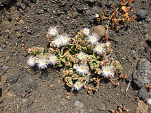
On the coasts, plants feed mainly on night dew, so the most common species are crassulaceae, especially of the genus Aichryson, known as succulents because of their way of storing water. Another of the characteristic plants of the area is the Tabaiba. The sap of the sweet tabaiba (Euphorbia balsamifera) was used by the Bimbaches as a kind of chewing gum that quenched thirst. In turn, the sap juice of the teasel (Euphorbia canariensis) was used as a poison for fishing. The cardon can be seen on El Hierro, especially on the cliffs in the area of Las Playas, which is also called Los Cardones. Another genus of fleshy plants resistant to water shortages also grows in coastal areas.
Semi-humid area
This zone, which generally begins between 200 and 400 m above sea level, is home to colonies of succulents and other broad-leaved plants. Cacti and agaves also grow. The endemic specimens of the genus Aeonium are Aeonium hierrense and Aeonium valverdense. The agave specimens found in this area were introduced from America, especially from the area of Mexico. Other species are the Canary Island palm (Phoenix canariensis) or juniper (Juniperus phoenicea). The few junipers that remain today are deformed by the strong winds that hit the area. They are the remains of an ancient forest that covered the entire central part of the island.
Wet area
In this area, which develops between 800 and 1500 meters above sea level, it is where the highest rainfall is recorded. The laurel forests, also known as monteverde are the characteristic note of the area. However, the concentration is less than in La Gomera; La Palma or Tenerife.
In the interior of the island, to the north of San Andrés, at an altitude of 1000 meters is one of the symbols of the island, the Garoé or Holy Tree. The Garoé was a holy tree for the Bimbaches. The current specimen was planted in 1957. The original was probably a linden specimen (Ocotea foetens) that was felled by a storm in 1610. There is a small tourist information center where the role of this tree in Guanche society is explained, because due to the condensation of water from the clouds on its leaves it provided water to the bimbaches. The current shield of the island shows the Garoé in the center.
Wildlife
Insects
There are about 5,000 species of insects on the island. The most common are butterflies, damselflies, moths, sarantontones, lepidoptera, bumblebees, bees, wasps, grasshoppers and crickets. In the 1950s, plagues of lobsters from Africa arrived floating in the sea, although they did not have any environmental impact as they were eliminated before reaching the coast.
Reptiles
Lizards are the most common animals on El Hierro. Among them stands out the Boettger's gecko (Tarentola boettgeri), whose subspecies Tarentola boettgeri hierrensis is endemic from El Hierro. The lizards on the island are related to those on the African continent. The most common species is the small Canary Islands lizard (Gallotia caesaris), endemic to El Hierro and La Gomera, which reaches up to 35 centimeters in length. Colonies of golden mullets (Chalcides viridanus) can also be seen in the wetlands of the island. Specimens of sea turtles can be seen in coastal waters, especially loggerhead turtles (Caretta caretta) and leatherback turtles (Dermochelys coriacea). These reptiles can be considered the largest in the archipelago.
Giant Lizard
El Hierro is known for the giant lizard (Gallotia simonyi machadoi), a subspecies of large lizard that is only found on this island. It is known that in ancient times it was distributed throughout the island, due to the absence of predators. The arrival of the Spanish colonizers in the XV century marked the decline of this species. The creation of cultivation areas and the introduction of cattle meant an alteration of the habitat of these lizards. The introduction of the cat was even more disastrous as they began to hunt lizards due to the ease of catching them. This caused the colony of giant lizards to move north, to the Valle del Golfo and the Roques de Salmor. They were believed missing until the 18th century when a colony was discovered in these locations. In a scientific investigation of 1889 they were given the name simonyi, in honor of the Austrian professor Óscar Simony. The specimens found were hunted and sold to collectors, until it was thought that the species had disappeared.
In the 1970s, a goat herder found some specimens by chance in the area known as Fuga de Gorreta, within the Tibataje cliff. These specimens were given the taxonomic name Gallotia simonyi and a Lagartario was created for its conservation in the area of Guinea in the municipality of La Frontera. The torrential rains that fell in January 2007 caused the death of many specimens of the Lizard, delaying the deadline for removing the species from the list of threatened species.
The giant lizard, listed as a protected species since 1975, can reach 75 cm in length. It has a thin and long tail. It feeds on insects and plants. The breeding season is in May, a month later, the female deposits 12 eggs in a nest, underground, from which the young will hatch after 8 weeks. The life expectancy of the lizards is not known with certainty, since none of the lizard specimens has yet exceeded the age of 35 years.
Birds
The island of El Hierro is home to an important colony of birds, both native and introduced by man. Among the most common species are finches, canaries, hoopoes, goldfinches, robins, blackbirds, passerines, turtle doves, hawks, eagles, doves, little owls, quails, partridges, owls, kestrels, and seagulls.
Natural spaces
The island has a total of 7 spaces with different protection categories:
Comprehensive nature reserves
- Integral natural reserve of Mencafete
- Integral natural reserve of the Roques de Salmor
Special Nature Reserves
- Special natural reserve of Tibataje
Rural parks
- Rural Park of Border
Natural monuments
- Natural monument of Las Playas
Protected landscapes
- Protected Landscape of Ventejís
- Protected Landscape of Timijiraque
Natural symbols of the island
According to a law of the Government of the Canary Islands, the natural symbols of El Hierro since 1991 are the giant lizard and the juniper.
Political-administrative organization
El Hierro, as part of the Autonomous Community of the Canary Islands, depends on the different powers attributed to the Government of Spain, the Government of the Canary Islands and the Island Council of El Hierro.
El Hierro Island Council
The councils, formed from the Council Law of 1912, are the governmental and administrative forms typical of the Canary Islands and mainly fulfill two functions. On the one hand, they provide services and exercise the powers of the Autonomous Community and on the other, they are the local entity that governs the island. The council headquarters is located in the town of Valverde.
Municipalities
The island is divided into three municipalities with their respective town halls, integrated into the FECAM, governed by the basic legislation of the local regime and their respective organic regulations. In October 2006, the procedures for the segregation of El Pinar from the municipality of Frontera began, and in September 2007 it became the third municipality on the island.
The municipalities, made up of several populations, are the following:
- Valverde
- Border
- The Pinar
Insular Directorate of El Hierro
This institution, analogous to the sub-delegates of the government in the provinces, is in charge of representing the Government of Spain on the island and managing all those powers that have not been transferred to the Government of the Canary Islands, the council or the municipalities. The headquarters of the Island Directorate is located in the municipality of Valverde.
Demographics
| Graphic of demographic evolution of El Hierro between 1900 and 2021 |
 |
Official regular residents according to ISTAC population censuses. |
Arts and culture
Folklore
The folklore of El Hierro is very similar to that of the rest of the Canary Islands, although it presents a series of variations such as the use of flutes as well as dances typical of the island. A group of flutes (pito herreño) and drums that could originate in Galicia or northern Portugal is a local characteristic. The tango from El Hierro especially stands out in which the movements are fast and short, and in the dance the man tries to captivate his female partner by showing off his skill and gallantry.
The most characteristic dance of El Hierro is the one carried out by the dancers of the Virgin during the pilgrimage of the Virgen de los Reyes, Patron Saint of El Hierro, who carries the image to all points of the island. The local government tries to promote folklore by giving subsidies to the groups. Currently in El Hierro there are several folkloric groups that carry out exhibitions both on the island and in the rest of the Canary Islands. These groupings are:
- Folk Group Thejeguate
- Joapira Folk Group
- Folk Group The Border
- Sabinosa Folk Group
- Taicares Folk Group
- Taros Folk Group
Parties
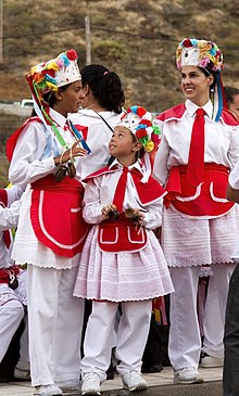
The most important festival on El Hierro is the "Bajada de la Virgen de los Reyes" (patron saint of El Hierro), which is held every four years, on the first Saturday of July. During the festival, the image of the Virgin is transferred from her sanctuary in La Dehesa (La Frontera) to the capital of the island (Valverde), making a 44-kilometre journey (path of the Virgin) that crosses all the towns of The iron. The image is accompanied by dancers who perform the traditional dance of the Virgin, dressed in white and red costumes, with brightly colored hats, while they play their musical instruments: chácaras and pitos (a kind of flute). The duration of the festival is about a month. It is attended by almost all the inhabitants of the island in addition to about four thousand visitors. In addition to the patron saint festivities, the following festivities and local festivals are celebrated every year in different nuclei and neighborhoods of the island's towns:
| Date | Name | Locality |
|---|---|---|
| 19 March | San José | Isora |
| 25 April | Feast of the shepherds | The Dehesa |
| 3 May | The cross | The Pinar |
| 15 May | San Isidro | Valverde |
| 1.o Sunday June | The sister-in-law | San Andrés |
| 24 June | St. John the Baptist | La Restinga and Las Puntas |
| 29 June | Saint Peter the Apostle | The Mochanal |
| 1st Saturday of July every four years | Down. | Fiesta Insular |
| 16 July | Virgen del Carmen | La Restinga |
| 21 July | Fiesta Amador | Belgara (La Frontera) |
| 10 August | San Lorenzo | La Frontera |
| 15 August | La Candelaria | La Frontera |
| 16 August | San Roque | Belgara (La Frontera) |
| 28 August | Saint Augustine (Patrone of the Island) | Valverde |
| 12 September | La Paz | The Pinar |
| 24 September | Fiesta de Los Faroles (Virgen de los Reyes) | The Dehesa |
| 3.o Sunday of October | Virgin of La Peña | You are. |
| 28 October | Saint Simon | Sabinosa |
Crafts
Unlike the other islands, handicrafts continue to be one of the main sources of income on El Hierro. Some handicrafts as well as knowledge of the properties of plants that were used before the establishment of the Spanish Crown are still being carried out, perfected with new techniques introduced. The main towns where it is produced are Sabinosa and El Pinar, but also, but to a lesser extent, Frontera, Valverde, El Mocanal and Guarazoca. The processing of sheep's wool that introduced the loom technique to the island is still carried out but with little activity, bedspreads, blankets, tapestries and traditional sacks are made using wool or strips of cloth. The wood, both mulberry and pine, beech and chestnut, is used to carve bowls and ladles as well as barrels for wine, chácaras and tongs for picking prickly pears. Three potters still work in the towns of Valverde, Guarazoca and El Pinar who, using clay from the island and imported clay, create ceramic works. Finally, basketry is also another technique installed on the island. Basket makers, as these artisans are known, make wicker baskets, which previously had to be softened for weeks in seawater. The forged and embroidered are scarcer on the island.
Gastronomy
In the cuisine of El Hierro, as in that of the rest of the Canary Islands, fish occupies a main place due to the rich fauna of the waters that surround the island. Among the first courses, the stew, stew and the ranch with potatoes The fish is usually prepared fried, stewed or grilled, using wrinkled potatoes and red and green mojos as a garnish. Among the meats, rabbit and kid or goat stand out, as it is called on the island. The meats are usually accompanied by red mojo and stewed or wrinkled potatoes.
The quesadilla from El Hierro, a sweet whose main base is El Hierro cheese, is the most famous typical dessert of El Hierro. The cheese is produced in the cheese factory and both this and the wine produced in the El Golfo wine cooperative are exported to the rest of the country. The wine is still made in traditional presses, which gives them a high alcohol content. Lastly, as in the rest of the Canary Islands, gofio is the main source of food for the locals.
Transportation
Airport
El Hierro airport is located in the municipality of Valverde. Part of the track is on land reclaimed from the sea, due to the special orography of the island. The track is 1250 meters long and is paved. Through El Hierro airport, you can access the island from Tenerife (Tenerife North airport) and Gran Canaria. Binter Canarias is the main company that performs the service. In addition, the Canaryfly company currently connects Tenerife with El Hierro with a daily flight.
Ports
The maritime communications of El Hierro are carried out through the Port of La Estaca, in the municipality of Valverde. This wharf was recently extended to allow the stopover of larger ships. Specifically, on June 23, 2006, the new port was inaugurated. Passenger and merchandise traffic is carried out through it. Since the early 1990s there were regular ferries connecting the island with its neighbors. Fred Olsen Express covered the route between the Port of La Estaca and the Port of Los Cristianos in Tenerife.
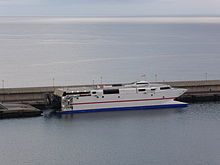
As of March 2014, only Naviera Armas maintains the line to Los Cristianos, with the modern Alborán catamaran ferry, built in Australia, with capacity for about 900 people. This catamaran is owned by Acciona Trasmediterránea, although it is chartered by Armas.
In other parts of the island there are small fishing and sports ports, such as the port of La Restinga, where fishermen who fish in the Mar de las Calmas, and divers are based. The port and airport can be accessed through regular bus lines and taxis.
Roads
The road network is in good condition, so all towns can be accessed without difficulty. The main road is the one that connects Valverde with Frontera through the Los Roquillos Tunnel, reducing the journey time compared to the old road through the summit. Another of the main roads is the one that accesses from the capital to Puerto de la Estaca. The rest of the island is connected by paved roads or forest tracks.
Economy
El Hierro's economy is based on the primary and tertiary sectors. The Cabildo de El Hierro is in charge of regulating and promoting the four pillars on which the El Hierro economy depends, that is, agriculture, livestock, fishing and tourism.
Agriculture, livestock and fishing
The herreña livestock herd is made up of sheep and goats, the latter standing out for being descendants of the goat species that the bimbaches bred. Meat production is, however, scarce, due to the fact that livestock is developed mainly for the production of milk, which is collected in the Cooperativa de Ganaderos de Isora, and which is used to make cheeses that then they will be exported to the rest of the islands and to mainland Spain.
Fruit crops are concentrated in the Valle del Golfo, where tropical pineapples, papayas, avocados, bananas, mangoes, etc. are grown, whose distribution and marketing is handled by the Cooperativa del Campo and the Mercahierro trading company. Dried or "passed" For centuries they have been considered the best in the Canary Islands and they occur, especially in the El Pinar area. Other fruits are grown, although they are intended for local consumption and depend on the season. These fruits are plums, apricots, apples and citrus.
El Hierro also produces wine, through a cooperative that brings together winegrowers. There is a designation of origin El Hierro. The wines of this island stand out for their high alcohol content.
La Restinga is the island's main fishing port, which fishes in the Mar de Las Calmas. The most important catches are the skipjack tuna and other tunas, as well as the coastal fishing that includes viejas, groupers, moray eels, etc.
Tourism
The island is far removed from the concept of mass tourism, and according to the opinion of its inhabitants it should be kept that way. It is estimated that the maximum number of beds that the island could support is 2,000. The difficulty of access and the absence of large beaches make it less attractive for family visits. In 1984, the Valverde-based Tourist Board was created. This board depends on the Cabildo de El Hierro and is in charge of promoting the island abroad. Since 1996 several commercials have been published nationwide using the catchphrase Island of Tranquil Difference. The authorities of El Hierro defend the idea that quality should come before quantity. As a general rule, tourists who come to the island do so individually for hiking or so-called rural tourism.
Among the bathing areas of El Hierro, the natural pools of La Maceta stand out, located in the Valley of El Golfo. On the other hand, there is only one natural beach with a developed sand bottom, Timijiraque beach, a dark sand beach that is located at the foot of the oldest geological series on the island. There is also a wide natural beach of dark sand, Playa de La Arena and three almost inaccessible beaches: Playa de Las Calcosas, Playa Miguel and Playa de El Pozo. There are also small natural beaches: La Restinga dark sand beach, Tacorón beach, red sand (lapilli, volcanic ash) and dark sand beaches in Charco de Tamaduste.
There is also an undeveloped natural beach with whitish calcareous deposits and a bottom of lava flow, Playa de Arenas Blancas. On the other hand, there is an artificial beach of dark sand, Playa de El Verodal, and it is intended to build two more beaches, in the port of La Estaca and the port of La Restinga. There are also several puddles, the Charco Manso, the Charco Azul, the Charco del Pozo de Las Calcosas, the Charco de Los Sargos, the Charco de La Tabla. There are also artificial pools in La Caleta and Las Puntas. There are also bathing areas in Tecorón, the pier of the Orchilla lighthouse, Roque de la Bonanza, the port of La Estaca, the pier of Las Puntas.
The places most visited by tourists are the viewpoints, which allow views of all points of the island. The most famous are the Las Playas viewpoint in the eastern area and the La Peña viewpoint built by César Manrique. In it there is a restaurant with views of the Valle del Golfo.
Energy
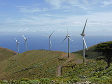
Much of the electricity on El Hierro, as of June 2014, is generated at the new Gorona del Viento hydro-wind power plant. The facility has five large Enercon model E wind turbines -70 and a reversible hydroelectric plant, which includes two ponds, a network of pipes, a series of turbopumps, and hydraulic turbines.
With this same energy, it was planned to activate a desalination plant, which has finally been discarded, after reducing external subsidies.[citation required] At the same time, the diesel plant will continue operational, acting as a reserve.
Sports
Indigenous sports
Among the Canarian sports practiced on the island, the following should be highlighted:
Canarian fight
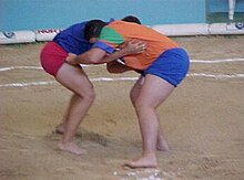
The Canarian wrestling takes place inside a circle, usually made of sand, called a terrero. In it, two wrestlers face off trying to take each other down. The island body that oversees this sport is the Insular Federation of Canarian Wrestling, and is based in Valverde.
In El Hierro there are seven land plots distributed among the three municipalities:
- The Pinar:
- Terrero Martín-El Pinar
- Terrero La Restinga
- Border:
- Terrero Ramón Méndez
- Valverde:
- Terrero de Valverde
- Terrero Guarazoca
- Terrero Isora
- Terrero San Andrés
Canarian Cudgel Fight
The canary club fight is a martial art that is practiced between two wrestlers who fight with clubs using a wide variety of techniques (crossed, scrambled, hooks, shoes, pincers, clearances, etc.) without actually doing any damage the opponent, controlling the blow, although originally and until the beginning of the XX century it was the form of self-defense used by shepherds. The Canary Garrote Fight was already used by the islanders aborigines as a method of defense. On the island of El Hierro, the tradition continues.
Canary Ball
Similar to the French game of petanque, boule canaria is rarely practiced today, although there are several teams and courts on the island. It basically consists of adding teams by throwing some balls that must be left as close as possible to an object called mingue or bowling alley. It is played on a rectangular field of sand or earth between 18 and 25 meters long and a width between 3.5 and 6 meters. In El Hierro there is a great interest in this game, its inhabitants participating actively in the competitions held both at the island and regional level.
Water sports
The geographical characteristics of the island's seabed, together with the high quality of its waters, make El Hierro the best place to practice scuba diving in the Canary Islands. Due to the low population of the island as well as the low maritime traffic, the waters remain in an unbeatable quality, which means an important wealth of fauna. In the Mar de las Calmas area is where scuba diving is usually practiced. Several contests are held every year, among which the Isla de El Hierro aquatic photography contest (Open Fotosub) stands out, of which its tenth edition was held. On the island there are 12 diving centers.
Other sports
In addition to those mentioned, other sports are practiced on the island such as:
- Cycling: During the year several cycling competitions take place, highlighting the mountain biking modality.
- Motocross: on the island there are several circuits, in which usually tests are held, some of them worthwhile for the Motocross Regional Championship of the Canary Islands.
- Land Rallys: Throughout the year there are races of land rallies in El Hierro, some of them are scored at the Canary Islands Rally Championship.
- Football: Football is the sport par excellence of El Hierro, being also the one with the most followers. The three local teams with more fans are Atlético Pinar, U. D. Valle Frontera and C. D. Concepción. In total there are 9 federated clubs. These teams militate at the regional level. The Thai football federation has a headquarters in the capital of the island.
- Paragliding: The Iron is a prominent place within the Spanish geography for the practice of paragliding. With takeoffs like Two Sisters, at 1200 meters, and the flight mainly from the hillside thanks to the constant sea breezes, numerous international events take place on the island. For example, the International Concentration of Parapente Island of El Hierro is held every year, organized by the Club Guelillas de El Hierro.
- Other sports are surfing, hiking and speleology.
Illustrious blacksmiths
Contenido relacionado
Cenozoic era
Kuroshio Current
Strait of Gibraltar

