
Teruel Province
Teruel is a Spanish province in the autonomous community of Aragon, with its capital in the homonymous city of Teruel. It is found mainly in the southern area of the Iberian system, although a part of the provincial northeast, in the so-called Bajo Aragón, already belongs to the Ebro depression. Its surface area is 14,809 km² and its population amounts to 134,545 inhabitants (INE 2021), of which a quarter live in the capital. This means a population density of 9.08 inhabitants/km², one of the lowest in the country. It currently comprises 236 municipalities, most of them sparsely populated. The most important municipalities, apart from the capital, are Alcañiz, Andorra, Calamocha, Calanda and Utrillas.
In the province, characterized by its relief and picturesque Mediterranean mountain landscape, in addition to agriculture and mining, of special importance in the past, tourism, energy production and an incipient industry are the economic mainstays. Among the typical products of the area are Teruel ham, lamb from Aragón, oil from Bajo Aragón, peach from Calanda and black truffle from Sarrión.
Geography
The province of Teruel is located in the eastern part of the Iberian Peninsula, in the autonomous community of Aragon. It limits to the north with the province of Zaragoza, linked to it by the Iberian system and the Ebro depression. To the west, it is the Montes Universales and the Sierra Menera (Iberian system), who act as the border with Castilla-La Mancha (provinces of Cuenca and Guadalajara). To the south and east it borders the Valencian Community (Valencia and Castellón provinces respectively), where the Iberian system extends to the Mediterranean Sea. To the northeast, it borders Catalonia and the province of Tarragona, where the Beceite Passes serve as a link between the Iberian system and the Catalan Coastal Range.
| Northwest: Province of Zaragoza and Province of Guadalajara | North: Province of Zaragoza | Northeast: Province of Zaragoza and Province of Tarragona |
| West: Province of Guadalajara |  | This: Province of Castellón |
| Southwest: Province of Cuenca | South: Province of Valencia and Province of Cuenca | Sureste: Province of Castellón |

Relief
.jpg)
Teruel's relief is largely determined by the Iberian system. The main backbone of the province is the inter-Iberian depression, which topographically links the Jiloca valleys with those of the Guadalaviar, the space in which the provincial capital is located. Outside of this axis and the valleys of the Guadalope and Martín rivers, the territory is very mountainous. In the extreme southwest rises the Albarracín massif, which reaches its highest point in the Caimodorro peak at 1921 m high. In the southeast is the Sierra de Gúdar, whose highest altitude is represented by the Peñarroya peak (2024 m). In the extreme south of the province, the Sierra de Javalambre reaches 2,020 m in height.
The territory of the province extends, along its northeastern limit, from the Meseta to the Ebro depression, including a small strip of hills or Tierra Baja and a series of rough mountain ranges (Cucalón, San Just, Palomera, Peñarroya and Mosqueruela) that isolate from the high valleys of the Turia, Alfambra and Mijares rivers. The extension of the Calatayud-Daroca trench to Teruel splits the central mountain ranges belonging to the Iberian system into two sectors: to the southwest the Albarracín massif and to the east the complex San Just mountain range. Starting from the city of Teruel, the trench forks into two branches: one in a southerly direction, traversed by the Turia River, and another in a southeasterly direction, which follows the course of the Alto Mijares. To the north of the latter are the Gúdar mountain ranges, which extend towards the province of Castellón through the Maestrazgo massif. Surrounded by both branches and on the border with the province of Valencia, the Javalambre massif rises.
The fundamental relief units in the territory of the province of Teruel are the Albarracín massif, the Gúdar and Javalambre mountain ranges, the upper Jiloca depression, the Teruel depression and the lower Aragón foothills.
Albarracín Massif

Located in the southwestern corner of the province, it has a clear geological identity with the Iberian plateau branch, imperceptibly linking with the Guadalajara sierras. It is made up of several separate mountain ranges, dominated by Paleozoic materials that were fractured by alpine folding and differentially eroded, appearing quartzite ridges, along with erosive valleys excavated on less resistant slates.
The most outstanding mountain ranges are those of Carbonera, Collado de la Plata and Tremedal. The maximum height is the Caimodorro, with 1921 m. To the northeast of them are the Sierra de Almohaja and the Sierra Menera, with similar characteristics, although they are not part of the same unit.
Wherever the Paleozoic materials were covered by sedimentary materials, erosion surfaces have appeared based on straight folds with wide hinges and little dip, such as the Muela de San Juan. In the area of Pozondón, Peracense, Almohaja, etc., an erosion surface appears that has leveled anticlines, synclines, and fractures in the same plane, resulting in extensive plains.
Javalambre Massif
Located in the southeastern corner of the province, it is made up of the mountain range of the same name and that of Camarena. The entire Sierra de Javalambre is a total domain of Mesotertiary sedimentation. The páramos located at 1,200-1,300 meters have rejuvenated as a consequence of fluvial erosive action. Its most outstanding height is the peak of Javalambre with 2020 meters.
Gúdar-Maestrazgo Massif

Located in the extreme southeast of the province, it is separated from Javalambre by the Mijares depression. It presents a lithology and morphology similar to those of Javalambre. The general erosion surface is located above 1200 m, having embedded the fluvial network in it, which has managed to rejuvenate the relief. A good example of this is found in the Monchen millstone to the northeast of Gúdar.
As foothills of the massif, partially participating in the previous characteristics, we find the Sierra del Pobo, the Sierra de San Just and Ejulve, the Sierra de Montalbán and others of lesser importance. In this massif is Valdelinares, a Spanish municipality whose population center is located at a higher altitude above sea level.
Sierras of Lower Aragon
They are a set of small mountainous alignments, among which those of La Mata de los Olmos-Gargallo-Molinos-Castellote, Arcos, etc. stand out. Among them are small depressions such as those of Muniesa, Andorra and Mas de las Matas. The morphological evolution of the area has been determined by the hydrography of the Martín and Guadalope rivers.
Jiloca Depression
It has an approximate length of 60 km and a maximum width of 14 km, having its origin in a faulted tectonic trench, gradually filled with materials of high agricultural interest.
Teruel Depression

It is located on the river valleys of Alfambra, Guadalaviar and Turia, reaching a length of 70 km between Perales del Alfambra and Ademuz. Within the depression there are small structural platforms of very steep clayey or marly slopes, covered by a calcareous cornice, similar in appearance to the millstones in the center of the Ebro depression.
Somontano of Lower Aragon
It is a kind of continuity of the space typical of the Ebro depression. Lithologically it presents gypsum to the north of the Sierra de Arcos and conglomerates to the north of the Sierras de Andorra and Calanda. In the eastern end of the province, tabular structures appear in the series of conglomerates and sandstones on the edge of the basin.
Geology
From the tectonic and lithological point of view, a paleozoic base can be distinguished, made up of a wide range of materials among which slates and quartzites predominate, especially visible in the Albarracín mountains, and a sedimentary cover of Mesozoic materials and tertiary among which limestone and dolomites abound, visible throughout the province, but above all, in the Sierra de Gúdar and Javalambre. In the depressions formed after the Alpine orogeny, clay, reddish marl, gypsum and limestone have been accumulating throughout the last Tertiary throes and throughout the Quaternary era.
In general, these are reliefs with heavy shapes, carved in Mesozoic calcareous materials, slightly folded but intensely fractured and, above all, deeply cleft by canyons opened by fluvial erosion. In the western sector, paleozoic materials, rich in minerals, frequently appear, such as iron ore in Sierra Menera.
Hydrography
The hydrographic network of the province of Teruel is organized around two aspects: the Ebro and the Levantine-Mediterranean.

The rivers that flow into the Ebro have a lower flow than those that flow into the same river from the Pyrenees. The cause is the different rainfall in each of the headwaters and the smaller basin of the rivers themselves. The rivers that pour their waters into the Ebro are the Jiloca, which does so indirectly through the Jalón, the Huerva, the Aguas Vivas, the Martín, the Guadalope, the Matarraña and the Algars. Its absolute average flows range from 7.16 m³/s for Guadalope and 0.3 for Matarraña, passing through 4.76 for Jiloca, 1.49 for Martín, and 0.50 for Aguas Vivas. The annual regime of these rivers is quite irregular, given the usual small flow. The incidence of Mediterranean rains is perceptible in them and the incidence of the snow phenomenon is practically negligible. In this sense, they are rivers sensitive to stormy spring and summer phenomena and torrential autumn rains. The interannual irregularity is accused.
0060.jpg)
The rivers Mijares, Guadalaviar, Alfambra, Turia and Ebrón flow to the Levantine-Mediterranean slope. Its absolute average flow ranges between 1.44 m³/s of the Alfambra, 4.72 of the Turia and 2.86 of the Mijares at its exit from the province, on the way to Castellón. The sudden autumn floods produced as a consequence of strong waterspouts that fall in a short space of time are especially notable in these rivers.
Along with the rivers, its lagoons also stand out in the province, such as the Gallocanta lagoon, next to the towns of Bello and Tornos, on the border with the province of Zaragoza; the recently recovered lagoon of Cañizar de Villarquemado, in Alto Jiloca, and those of La Estanca de Alcañiz and La Salada Grande, close to the city of Alcañiz.
The use of rivers is limited, given their small flow. The hydroelectric use is testimonial, due to the low flow and the interannual irregularity. The agricultural, however, is intense, although it only occurs in the meadows of the rivers themselves, due to the scarcity of adequate hydraulic works.
Climate
.jpg)
Teruel's relief, added to the altitude and situation of the province with respect to the disposition of the peninsular mountain ranges, which protect it from marine influences, give rise to peculiar climatic conditions. The close dependence between climate and orography determines the existence of Mediterranean, medium mountain and strong continental nuances.

The highest regions stand out for registering rainfall of 500-600 mm, which in the best oriented areas exceeds 1000 mm (Gúdar and Albarracín), and average temperatures below 10 °C, with abundant snowfall and periods with the possibility of frost for up to eight months, the minimums being below 15º below zero and the absolute minimums even reaching -30 °C (Calamocha in December 1963 registered -30 °C). Summers are mild, with average monthly values between 17 °C and 20 °C.
From the agroclimatic point of view, the date of spring and last frost is particularly important, which in this sector are located very close, thus reducing the vegetative period to the months from June to September.
In the internal depressions and in the central highlands, the rainfall record oscillates around 500-600 mm, with maximum precipitation in spring and autumn and a summer that is not excessively dry due to the typical storms of this time. However, there is a continuous water deficit from May to October. The minimum usually occurs in winter as a consequence of the thermal anticyclone, which generates a type of dry and sunny weather with low night temperatures, due to irradiation and thermal inversion: dew, frost and fog are characteristic meteors of the winter weather of the Teruel depressions. The average annual temperature ranges between 10 and 13 °C, with values of 20-25 °C for the warmest month and 0-5 °C for the coldest month. At some times of the year, the combination of altitude and relative dryness can produce thermal differences of up to 20 °C in a few hours.
Towards Bajo Aragón, the temperatures soften as a consequence of the lower altitude, the rainfall is lower –just over 300 mm– and the action of the wind is very evident.. However, the surroundings of the Ports of Beceite, in Matarraña, stand out, where towns such as Beceite -which gives its name to the entire massif shared with Tarragona and Castellón- touch 700 mm of annual precipitation according to the Aemet station located in the municipality itself.. However, from 1,000 m above sea level, more than 1,000 mm of precipitation is exceeded in the Beceite massif.
- Historical weather data in Teruel capital
- Maximum historical temperature: 40.2 °C (10 August 2012)
- Minimum historical temperature: -19.0 °C (26 December 2001)
Flora
.jpg)
26% of the province corresponds to wooded area with forest species, among which conifers predominate, in a significant proportion of repopulation. They are located on deep soils with little leaching, constituting an important potential wealth for the municipalities of the high mountains. In the past, the wooded area of the province was much larger, but human exploitation of the environment throughout history has caused its reduction. For this reason, 60% of the provincial surface is currently covered by a grassland-scrub resulting, in large part, from the degradation of the original forest formations. For its part, 30% of the provincial area is identified with land cultivated for cultivation.
The conjunction of climate and soil, controlled by the lithological constitution of the territory and by topography, is responsible for the original natural vegetation. The altitude imposes a greater rainfall and determines the limiting thermal extremes for the development of certain species, while the exposure is the cause of the contrasts between sunny and shady areas and of the microclimatic nuances in the distribution of rainfall.
The climatic domain of Teruel, of continental Mediterranean mid-mountain, provides different plant formations that adopt a device in bioclimatic floors staggered in height, although human intervention: plowing, felling to obtain pasture, forestry practices, has introduced Modifications that have impoverished the primitive vegetation to the point of almost disappearing in some areas, mainly in depressions, or that have favored the expansion of new species –such as pine trees– that are more economically profitable, which have broken up primitive associations.
Natural spaces
Territorial organization
Country
- Andorra-Sierra de Arcos
- Under Aragon
- Under Martin
- Community of Teruel
- Mining basins
- Gúdar-Javalambre
- Jiloca
- Teacher
- Matarraña
- Sierra de Albarracín
Municipalities
There are currently 236 municipalities. The one with the largest population is the provincial capital, while the second most important, Alcañiz, located in the northeast of the province, exceeds 16,000 inhabitants. The rest of the municipalities do not reach the figure of 10,000 registered citizens. It is remarkable a high number of them with populations below 500 inhabitants. The average extension of the municipality in the province is 62.72 km².
- Main municipalities by population
According to the INE municipal register, the twenty most populated municipalities in the province in 2021 were:
Demographics

With 2.93% of the national surface, Teruel has a population that represents only 0.29% of that of the national territory and 10.25% of Aragon.
The province of Teruel has a high rate of depopulation. Teruel is the least populated province of Aragon, according to the 2021 census of the National Institute of Statistics, which makes it one of the most depopulated territories in Spain (9.08 inhab./km² in 2021) together with Soria (8, 74 inhabitants/km²). This index is very far from the average values of Spain and the European Union (92.47 inhab./km² and 117 inhab./km², respectively in 2018).
To this we must also add that in the last century the Teruel population has decreased by 46%. In 70 municipalities, 30% of the provincial total, more than 40% of the population is 65 years of age or older (IAEST, 2014). This generates a problem of population aging that means that all these municipalities are in a terminal situation, that is, they could become imminently depopulated naturally.

In addition, the population of the province of Teruel is concentrated in the capital and some adjacent municipalities; the municipalities in the northeast of the province, that is, the regions of Bajo Aragón, Andorra-Sierra de Arcos and Bajo Martín; and in the old county heads (Utrillas, Albarracín, Calamocha, Monreal del Campo...), which are also in a regressive dynamic. On the contrary, the regions of Jiloca, Cuencas Mineras (Teruel), Maestrazgo, Gúdar-Javalambre and Sierra de Albarracín have very low population densities and quite high levels of depopulation.
The low population of Teruel capital (35,691 inhabitants) means that no town in the province exceeds 50,000 inhabitants, which means that Teruel does not generate enough economic dynamism to boost the province. In this context, Alcañiz (15,939 inhabitants) has such economic and demographic importance that it functions as the capital in the north of the province, which creates a kind of of bicephaly.
On the contrary, the area hardest hit by depopulation and most devoid of powerful economic and demographic centers is the provincial center (between the regions of Jiloca and Cuencas Mineras there are numerous municipalities with less than 100 inhabitants), where in many kilometers around there are no populations larger than 1000 inhabitants. In this area, Utrillas, Calamocha and Monreal del Campo function as economic centers, but with little dynamism due to their low population (none exceeds 5000 inhabitants).
| Graphic of demographic evolution in the province of Teruel between 1857 and 2021 |
 |
Source: Spanish National Statistical Institute - Graphical development by Wikipedia. |
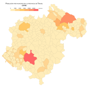
Population by municipality (2018)

Population density by municipality (2018)

Population growth by municipality between 1998 and 2008
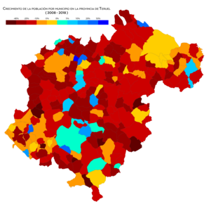
Population growth by municipality between 2008 and 2018


Economy
.jpg)
In addition to the traditional provincial economic sectors of cereal agriculture and coal mining, the economy of Teruel is currently based on tourism (rural, monumental, paleontological, mountain and snow), as well as the energy sector and industrial, where the agri-food industry stands out.
The main industrial poles of the province are located around the city of Teruel, in the Bajo Aragón area, and in the Jiloca corridor. The sector of ham with denomination of origin (Jamón de Teruel) is important. Despite the strategic location of the province close to major Spanish cities such as Madrid, Barcelona, Valencia and Zaragoza, the lack of adequate transport and energy infrastructure has meant that the province has not had sufficient and balanced industrial development. In reaction to this fact, a citizen movement called "Teruel Exists" was created, which demands, among other things, adequate communication infrastructures for the province, and blames the State for the lack of investment. Currently, the situation in terms of infrastructure has been corrected considerably in the western part of the province, with the construction of the Mudéjar highway (A-23) (Valencia-Teruel-Zaragoza). However, the central and eastern part of the province is still awaiting the construction of structuring axes such as the Ebro highway (A-68) between Zaragoza and Vinaroz, which is in the project phase, or the conversion into fast track of the National Highway N-420 between Teruel and Alcañiz, which connects the entire province, in the bidding phase.
The mining and electricity sectors have been very important during the XX century, although it is currently in decline. There have been large coal mining operations that have ceased their activity in 2018. Some mining activity continues in the clay and kaolin sector. The Andorra thermal power plant (1,050 MW) is scheduled to close definitively in June 2020 and the Escucha thermal power plant ceased its activity in 2012. The Castelnou natural gas thermoelectric power plant continues to operate. In 1982 the Aliaga thermal power plant ceased its activity.
Industry
The province of Teruel has a total of 68 industrial estates. The industrial area in the province amounts to 15,000,000 m². Around 4 million m² are located in the municipality of the city of Teruel.
Among the main platforms and industrial estates in the province are the Teruel logistics-industrial platform (PLATEA), the Teruel airport platform (PLATA), the La Paz industrial estate, the CEEI Aragón business incubator and the TechnoPark MotorLand technology park (Motorland Aragon).
Fairs, exhibitions and congresses
Among the events, venues and fair institutions in the province are the Teruel Exhibition and Conference Center, FeriAlcañiz, the Calamocha Fair Institution and the Cuencas Mineras Fair Institution, in Montalbán.
Tourism
Regarding snow tourism, the province has two ski resorts belonging to the Aramón group: Javalambre and Valdelinares, both in the Javalambre and Gúdar mountains in the south of the province. The Maestrazgo and Matarraña regions are others that arouse the most interest from visitors who come to Teruel. Towns such as Cantavieja, Mirambel, Valderrobres, Calaceite, Rubielos de Mora, Albarracín and Puertomingalvo stand out, which belong to the Most Beautiful Towns in Spain.[citation required] nature, in the Matarraña region, Beceite stands out as one of the municipalities with the greatest tourist attraction in the entire province. On the other hand, the main pillars of provincial tourism are the Dinópolis theme park, dedicated to the world of paleontology, and the Ciudad de Motor de Aragón, Motorland Aragón, in Alcañiz.
Infrastructures and transport
Roads
The main roads in the province of Teruel are summarized in the following table:
| Code | Type | Denomination | Itinerary | Communication from the province with: |
|---|---|---|---|---|
| A-23 | State highway | Autovía Mudéjar | Sagunto (ValenciaA-7 - Measles - Teruel - Cella - Monreal del Campo A-25 - Calamocha - A-24 - Zaragoza A-2 A-68 - Huesca A-22 -Somport (Huesca) - France | Zaragoza, northern Spain and Levante |
| A-68 / N-232 | State highway / National highway | Ebro motorway | Miranda de Ebro (Burgos) Logroño - Tudela (Navarra) - Zaragoza A-2 - Bird - Alcañiz - Vinaroz (Castellón) A-7 | Connects the area of Bajo Aragón turolense with Zaragoza, north of Spain and Levante |
| N-211 | National highway (Autovía en proyecto) | Autovía Alcolea del Pinar-Monreal del Campo (currently Road) | Pinar Alcolea (GuadalajaraA-2 - Molina de Aragón - Monreal del Campo (TeruelA-23 | Madrid |
| A-40 / N-420 | State highway / National highway | Autovía de la Meseta Sur | Avila - Toledo - Cuenca CM-44 (link to Albacete and Ciudad Real- Teruel | Castile - La Mancha, Andalusia and Extremadura |
| N-420 | National road | Carretera Córdoba - Tarragona (by Cuenca) | Córdoba - Ciudad Real - Cuenca - Teruel - Utrillas - Montalban - Alcorisa - Calanda - Alcañiz - Calaceite... Tarragona | Connects the area of Teruel capital with the center and northeast provincial (Bajo Aragón), and the province with Catalonia |
| N-211 | National road | Pinar-Fraga Alcolea Road | Alcolea del Pinar (Guadalajara) A-2 - Molina de Aragón - Monreal del Campo A-23 - Caminreal - Montalban - Alcorisa - Calanda - Alcañiz - Caspe - Fraga (link to Lérida) | Vertebra the north provincial half, and connects the province with Catalonia |
| N-330 | National road | Carretera Alicante-France (by Aragon) | Alicante - Utiel - Teruel A-23 - Zaragoza - Huesca - Somport - France | Alicante, Murcia and Albacete |
| N-234 | National road | Sagunto-Burgos Road | Sagunto (Valencia) - Teruel A-23 - Calamocha - Daroca - Calatayud - Soria A-11 (link to Valladolid- Burgos | Calatayud, Castilla y León and northern Spain |
Distances to the main cities:
- To Madrid: 300 km from the capital.
- To Barcelona: 409 km from the capital.
- A Zaragoza: 173 km from the capital.
- To Valencia: 141 km from the capital.
Railroads
The railway lines that the province of Teruel currently has are the following:
| Line | Type | Traject. |
|---|---|---|
| Zaragoza - Teruel - Valencia | Media Distance | Zaragoza - Villahermosa del Campo - Ferreruela de Huerva - Cuencabuena - Lechago - Navarrete del Río - Calamocha - Caminreal - Torrijo del Campo - Monreal del Campo - Villafranca del Campo - Santa Eulalia del Campo - Cella - Teruel - Puerto Escandón - La Puebla de Valverde - Sarrión - Mora de Rubielos - Rubielos de Mora - Sagunto |
| Zaragoza - Caspe - Barcelona | Media Distance | Zaragoza - Azaila - La Puebla de Híjar - Samper de Calanda - Reus - Tarragona - Barcelona |
| AVE Cantabrian-Mediterranean (In construction) | AVE | Santander - Bilbao - Zaragoza - Teruel - Valencia |
Notable people
Contenido relacionado
Socks
Geography of the Federated States of Micronesia
Mecca