
Tehran
Tehran (pronounced: [teeˈɾan]; Persian: تهران tr.: Tehrān [tehˈɾɒːn]) is the capital of the Islamic Republic of Iran. It is located in the north of the country, on a plateau at the foot of the Alborz mountains (also called Elbourz). Due to its population (&&&&&&&&08429807.&&&&&08,429 807 inhabitants according to an estimate of 2010) and importance constitutes one of the most important cities of the so-called Islamic world.
It is the political and economic center of the nation. More than half of Iran's industries are concentrated in it, among which the textile, sugar, cement and automobile industry and the carpet trade stand out. It also has oil refineries.
Etymology
There are various theories about the origin of the name of the city.
The official website of the city of Tehran states that "Tehran" comes from the Persian words Tah, meaning "end" or “bottom”, and Ran, meaning “mountain side”, literally, “end of the mountainside». Since Tehran is located in the foothills of the Alborz Mountains, this seems to be the most plausible explanation for the origin of the city's name.
A second theory holds that the word "Tehran" derives from Tiran or Tirgan, “the abode of Tir» (Tir being the Indo-Iranian deity equivalent to Mercury in Roman mythology). The ancient Parthian settlement of Tiran was neighboring the town of Mehran (“the abode of Mehr” or “the abode of Mithras”, who was an Indo-Iranian Sun deity). Both settlements were simple neighborhoods of the great city of Rayy or Rhages. Mehran still exists and is a residential neighborhood within Greater Tehran, just like Rayy, which make up the southern neighborhoods of the city.
The third theory states that "Terhan" means “temperate place”, as opposed to “cool place”, which would correspond to Shemiran, a neighborhood north of Tehran. Some contemporary texts state that the word "Terhan" means in Persian "temperate mountain skirt".
History
Origins
Tehran was originally a town located 7 kilometers from the large historical city of Rayy. It was one of the first towns that arose to the north of this city, whose inhabitants took refuge in Shemiran, Qasran and in the Alborz plains in order to escape the heat of the southern desert. Remains of populations during the Neolithic and even earlier periods have been discovered in Tehran and Rey (such as the Chesm-e Ali sites, located in the center of Rey.
The history of Tehran is known from the moment whose name is mentioned in historical writings, such as those of Yaqut, who mention the city in 1220. Qazviní's writings, dated 1275, allow us to better understand the city in this epoch. Both historians describe it as a commercial city (qurā) and even an important commercial city (qariyaton kabiraton), divided into twelve quarters (mahale). Qazviní adds that each neighborhood is led by an elder. According to him, the elderly fought among themselves and the inhabitants hesitated when it came to going to another neighborhood that was not theirs. At this time, the city had a particular physiognomy that these authors highlight.
The economy of the city at this time is based on the trade of fruits and vegetables grown in the city gardens, fed by the streams coming from the Elbourz and by traditional irrigation systems (such as the qanat and the kariz).
Start of urban functions
Tehran begins to take on more importance after the destruction of Rey by the Mongols in 1228. Tehran also suffered the Mongol invasion, but the decline of Rey encouraged its inhabitants to settle in Tehran, which offered more comfort with its gardens and its irrigation channels. In 1340, Hamdollah Mostowfí described Tehran as an "important little city", but as sparsely populated as before. In the 14th century century, the Mongol province in the area consisted of four departments, one of which was Tehran. Rey was part of the Tehran district at this time, a period in which the future Iranian capital began to predominate over Rey.
Don Ruy González de Clavijo, Castilian ambassador, was probably the first European to visit Tehran, arriving at its gates in July 1404, during a trip to Samarkand (today in Uzbekistan and at that time the capital Mongolian). He described Tehran as a large city equipped with a royal residence ("inn"). Rey is described as an abandoned city ("agora uninhabited").
Transformation into capital

Sah Tahmasp I, the second ruler of the Safavid dynasty, had a bazaar built in 1553-1554, as well as a wall with 114 turrets (according to the number of suras in the Koran). The reasons for the choice of the Safavids in favor of Tehran had several causes: the fact that an ancestor of the Safavids, Sayyed Hamza, was buried in Ray or that Tehran had been a refuge for Shiites for centuries had a certain importance; but above all it was the historical situations that pushed the Safavids Tahmasp, who had already been forced to move his capital from Tabriz to Qazvin because of the threats from the Ottoman Empire. The fortified city of Tehran, located 150 kilometers east of Qazvin, then offered a good refuge in case of danger. Xavier de Planhol stresses that the wall was excessive and disproportionate in relation to the needs of a small city: it stretched over 8 km long, surrounding an area of 4.5 km², while the population did not exceed 20,000 people in the city. epoch. The descriptions then speak of a great city, which had large gardens filled with multiple varieties of fruit.
During Safavid times, Tehran was a regional administrative center, housing a beğlerbeği and a provincial governor. However, at present the city does not have important remains from this time, such as a great mosque or factory.
Shah Abbas II also resided in Tehran on several occasions and had a residence called Chāhār bāgh built. Shah Suleymán had an imperial secretariat (Divān Khāneh) built in the center of the city (Chenārestān). It is in this place where the ambassador of the Ottoman Sultan Ahmet III met in 1721 with Shah Sultan Hosein, the last king of the Safavid dynasty before the Afghan invasion. At the end of the 18th century, Tehran was no more than a small provincial city but it had already become important to Iranian rulers.
In 1722, the troops of Mir Mahmoud Hotaki invaded Isfahan and Iran entered a period of troubles that both Tehran and its region suffered.
Under the Zand dynasty, Tehran became a military center while the Zand and Qajar tribes battled to seize power in the country. Between 1755 and 1759, Karim Khan planned to make Tehran the capital of the country; he has buildings built within the limits of the royal quarter (the Golestan Palace, for example). The royal quarter then acquires all the characteristics of an arg or fortified royal quarter. However, Karim Khan preferred to name Shiraz the capital of the country.
On the death of Karim Khan in 1779, Tehran became the object of dispute between Qafur Khan, loyal to the Zand, and Agha Mohammad Khan, of the Qajar dynasty. The city fell to an ally of the Qajars in 1785, and Agha Mohammed Khan Qayar, the dynasty's first king, entered the city on March 12, 1786, and made it the capital of his kingdom. Tehran owed its status as the capital of Iran in Qajar times to geostrategic concerns: the Russians threatened the country's northern borders and the Turkmen its northeastern ones. Tehran thus benefited from a privileged situation at the crossroads of the East-West route that runs through the Elbourz plain with the roads that lead to the oases of central Iran and the Fars basins.
In 1797 Tehran still had the appearance of a new city and had few inhabitants. A European traveler, G.E. Olivier spoke of a city of 15,000 inhabitants, of whom 3,000 were soldiers, but which extended over 7.5 km² of which only half were built up, since the rest was still occupied by gardens and orchards.
Fath Ali Shah Qajar (1797-1834) was the first builder of Tehran. He beautified the Arg (royal quarter) and had the Golestan Palace and the Tajt-e Marmar (marble palace) built within it. He also built numerous important buildings such as the Mosque of the Shah ( Masyed-e Shah ) inside the bazaar and the Palace of Negarestan and Lalezar. The city was attracting more and more inhabitants and the population doubled in 20 years. However, in 1834, at the end of his reign, many buildings were still unfinished.

Under Mohammad Shah Qayar the first constructions took place outside the walls. Princely and royal residences were built in the north of Tehran. In addition, mosques and imamzadeh were built within the walls. The testimonies of foreign travelers of the time still described a city without great attractions.
_(14761419246).jpg)
Nassereddin Shah was the one who made Tehran pass from the status of provincial city to that of capital. In 1868, the city was home to 155,736 people, concentrated in the old quarters. In 1870-1871, he destroyed the old walls to build new ones. The new wall, 6 meters high, then took on an irregular octagonal shape 19.2 km in circumference and comprised 12 monumental gates decorated with ceramics. Nasseredin Shah had new buildings and qanats renovated to supply the capital with water. He carried out increasingly important works of the Hausmanian type, opening rectilinear avenues in the center. The great square of Tupjané, (today of Imam Khomeini), which received its name from the cannons installed there, was then built.
Tehran, in the time of the Qajars, was concentrated around the bazaar, which was the heart of the city. A few steps away was the royal citadel (Arg-e saltanatí) with the residence of the Shah and the court. Three separate neighborhoods were added to the bazaar and citadel: Udlayán, a large affluent neighborhood with a large population of Jews and Zoroastrians to the east of the Arg; Chal Meydán ("Plaza del Hoyo"), an area degraded by the dumping of waste to the southwest of the bazaar and Sangalach, a populous neighborhood to the west of the bazaar. If, according to the first census carried out in 1885, Tehran had 147,206 inhabitants, at the beginning of the XX century, Tehran already had 250 000, the majority residing outside the walls.
20th century
During World War II, the British and Soviets occupied the city, where the Tehran Conference took place in 1943, with Franklin D. Roosevelt, Winston Churchill, and Stalin.
After the fall of the Pahlavi dynasty in 1979, the city went through a complicated situation that ended with the kidnapping of more than 50 US citizens who were held at the US embassy from late 1979 to January 1981.
During the Iran-Iraqi War, which lasted from 1980 to 1988, the city was attacked several times by Iraqi Scud missiles. However, after the war, the disasters caused by the missiles were quickly repaired. Another consequence of the war was the massive arrival of refugees in the capital, which increased its population.
The construction of cheap apartment complexes, luxurious apartment condominiums and modern skyscrapers has multiplied today. These new buildings have been haphazardly constructed, and old and historic sections of the city have been demolished to make way for modern development.
Geography
Profile
By 1788, the city had just 15,000 inhabitants. Since then the city's population has grown rapidly. By the year 1900 there were 200,000 inhabitants, by 1950 there were already around 1 million inhabitants, and by the year 2000 there were already 7 million. This accelerated population growth is mainly due to the administrative development of the city, industry and immigration from other parts of the country.
Tehran is the administrative and industrial center of Iran. Since the 1980s, almost half of Iran's manufactured production has been in Tehran.
Currently the city also has pollution problems. The water supply is not done properly and many waste ends up in the water sources, which has had a notorious impact on the pollution of the city.
.jpg)

Situation
Tehran is situated on a plain that slopes southward at the foot of the Alborz Mountains. The city has an altitude of 1,100 m to the south, 1,200 m at its center and 1,700 m to the north. The city and its periphery cover an area of 86,500 ha.
The foundation of the city was initially circumscribed to the limit between two characteristic zones of the plains: the upper zone, made up of coarse and permeable gravel, and the lower zone made up of finer and more impermeable alluvial deposits. The area on which Tehran is located represents the transition between the barren desert (kavir) and the Alborz mountain range.
The city does not have significant water resources. It is located at an equal distance from two important hydrographic basins that collect the waters that come from the mountains located upstream. They are the Karach basins, to the west, and the Yachrud, about thirty kilometers to the east, which feed Varamín and the surrounding towns. Between the urban areas of Karach and Varamín, there was in the past only one important city, Rey, which was located at the intersection of the routes between both basins.
The northern neighborhoods of the city, located high above the slopes of the Alborz, are less polluted and milder in summer. They are the residential neighborhoods of the upper-middle class population of the capital. Most of the foreign embassies are located there, as well as the palaces and the park of the former shah. To the south, in the direction of the desert, are the most popular and industrial neighborhoods. At the southern end of the current agglomeration is the enclave of Rey. Rey was long the regional capital[citation needed] and is the birthplace of the Abbasid caliphs al-Hadi and Haroun al-Rashid (circa 766).
The city is located at the foot of the mountains, so a cable car links the northern agglomeration to Mount Tochal, at 3,966 m. Further east and 50 km from the center of Tehran is Mount Damavand, whose crest still has some traces of snow in summer and which peaks at 5,671 m.
Natural hazards
There is a large fault located under the Alborz chain, at the foot of which Tehran is located. There are several smaller fault lines located on the southern plains of the city. Tehran is therefore exposed to earthquakes, which develop in cycles of about 150 years. No major earthquake has occurred in Tehran for more than 175 years, and specialists consider that a major earthquake could occur in the near future.. According to a study carried out in 1999-2000, such an earthquake could cause between 120,000 and 380,000 deaths.
Administrative Geography
The metropolis of Tehran, whose area has increased greatly in the second half of the XX century, stretches now over various departments of Tehran province: Tehran department contains most of the city, which also extends into Eslamshahr, Rey and Shemiranat departments. The term metropolis or agglomeration used here has no administrative value. It is used in a geographical sense to refer to the city of Tehran and its urban region, which corresponds to the municipality of Tehran and the province of Tehran.
The department (or shahrestān) of Tehran is bordered by Shemiranat department to the north, Damavand department to the east, Eslamshahr, Pakdasht and Ray department to the south, and Karaj and Shahriar department to the west.
Tehran Municipality (shahrdāri) is divided into 22 municipal districts (mantaghe), each with its own administrative center. They are numbered to be identified. On the other hand, Tehran is divided into 112 neighborhoods (nāhiye) among which stand out:
Abbasabad, Afsariye, Amir Abad, Bagh Feiz, Baharestan, Daraké, Darband, Dardasht, Darabad, Darrús, Dibayí, Elahiyé, Evín, Farmanié, Gheytarié, Gholhak, Gisha, Gomrok, Hasanabad, Jordan, Lavizán, Naziabad, Niavarán, Park-e Shahr, Pasdarán, Punak, Rey, Sadeghiyé, Shahrará, Shahr-e Zibá, Shahrak-e Gharb, Shemirán, Tachrish, Tehranpars, Vanak, Velenyak, Yaftabad, Yamarán, Yannatabad, Javadiyé, Yomhurí, Zafaraniyé, etc. These neighborhoods belong to administrative regions that depend on certain districts.
Although administratively separate, Rey, Shemiran and Karach are often considered part of the Tehran metropolis.
Climate
Tehran's location, between mountains and a desert basin, has a great influence on the city's climate. The climate in the mountains is rather cool and semi-humid, while the southern areas of the city, almost in direct contact with the Dasht-e Kavir desert, are hot and dry. The warmest months are those of summer (mid-July to mid-September), easily giving temperatures between 38 and 40 °C, although not much higher; since the maximum temperature recorded in the city of Tehran is 43 °C. The coldest months are December and January, with an average temperature close to -9 °C.
Rainfall is about 200 mm. Annual, concentrated during winter, spring and autumn. Summer is very dry. Sometimes it snows heavily during the winter months.
Tehran's climate is mainly influenced by three geographical factors:
- The Dasht-e Kavir, located south of the city, introduces hot air winds and dust into the city.
- The mountain range of Alborz, located north of the city, stops rains from the Caspian Sea.
- The clouds of the western monsoon and the presence of the mountain range partially reduce the effects of the desert climate.
The difference in temperature between the mountains and the plains causes air to circulate from the mountains to the plains at night, and from the plains to the mountains during the day.
| Month | Ene. | Feb. | Mar. | Open up. | May. | Jun. | Jul. | Ago. | Sep. | Oct. | Nov. | Dec. | Annual |
|---|---|---|---|---|---|---|---|---|---|---|---|---|---|
| Temp. max. abs. (°C) | 19.6 | 23.0 | 28.0 | 32.4 | 37.0 | 41.0 | 43.0 | 42.0 | 38.0 | 33.4 | 27.0 | 23.0 | 43 |
| Average temperature (°C) | 8.3 | 11.1 | 17.2 | 22.8 | 28.5 | 34.5 | 36.8 | 35.9 | 31.6 | 25.4 | 15.8 | 10.4 | 23.2 |
| Average temperature (°C) | 4.3 | 6.4 | 11.2 | 17.6 | 22.7 | 28.2 | 30.9 | 30.2 | 26.1 | 19.5 | 12.3 | 6.4 | 18 |
| Temp. medium (°C) | 1.2 | 3.3 | 8.0 | 13.4 | 18.4 | 23.1 | 25.7 | 24.9 | 21.3 | 15.9 | 8.0 | 3.3 | 13.9 |
| Temp. min. abs. (°C) | -15.0 | -13.0 | -8.0 | -4.0 | 2.4 | 5.0 | 14.0 | 13.0 | 9.0 | 2.8 | -7.0 | -13.0 | −15 |
| Total precipitation (mm) | 34.6 | 32.2 | 40.8 | 30.7 | 15.4 | 3.0 | 2.3 | 1.8 | 1.1 | 10.9 | 26.0 | 34.0 | 232.8 |
| Days of rain (≥ 1 mm) | 9.1 | 8.4 | 10.9 | 10.7 | 8.8 | 3.0 | 2.1 | 1.3 | 1.0 | 5.2 | 7.1 | 8.8 | 76.4 |
| Days of snowfall (≥ 1 mm) | 5.1 | 2.9 | 1.1 | 0.1 | 0 | 0 | 0 | 0 | 0 | 0 | 0.4 | 2.7 | 12.3 |
| Hours of sun | 177 | 185. | 220 | 219 | 285 | 330 | 338 | 341 | 303 | 248 | 198 | 152 | 2996 |
| Relative humidity (%) | 64 | 56 | 48 | 41 | 33 | 25 | 26 | 26 | 27 | 36 | 49 | 62 | 41.1 |
| Source: | |||||||||||||
| Month | Ene. | Feb. | Mar. | Open up. | May. | Jun. | Jul. | Ago. | Sep. | Oct. | Nov. | Dec. | Annual |
|---|---|---|---|---|---|---|---|---|---|---|---|---|---|
| Temp. max. abs. (°C) | 16.4 | 19.0 | 23.8 | 33.6 | 33.6 | 37.8 | 39.8 | 39.4 | 35.6 | 31.2 | 23.0 | 19.0 | 39.8 |
| Average temperature (°C) | 6.1 | 8.1 | 12.9 | 19.8 | 25.0 | 31.2 | 33.9 | 33.5 | 29.3 | 22.4 | 14.3 | 8.6 | 20.4 |
| Temp. medium (°C) | -1.5 | -0.2 | 4.0 | 9.8 | 14 | 19.6 | 22.6 | 21.9 | 17.5 | 11.6 | 5.4 | 1.0 | 10.5 |
| Temp. min. abs. (°C) | -11.4 | -11.0 | -8.0 | -1.6 | 3.0 | 12.0 | 15.4 | 13.5 | 8.8 | 2.6 | -5.2 | -9.6 | −11.4 |
| Total precipitation (mm) | 63.1 | 66.5 | 83.3 | 50.1 | 27.1 | 4.0 | 4.2 | 3.2 | 3.4 | 16.5 | 41.3 | 66.3 | 429 |
| Days of rain (≥ 1 mm) | 12.3 | 10.9 | 12.3 | 10.0 | 8.9 | 3.3 | 3.4 | 1.6 | 1.3 | 5.8 | 8.6 | 10.7 | 89.1 |
| Days of snowfall (≥ 1 mm) | 8.9 | 6.6 | 2.5 | 0.1 | 0.1 | 0 | 0 | 0 | 0 | 0 | 0.6 | 4.9 | 23.7 |
| Hours of sun | 137.2 | 151.1 | 186.0 | 219.1 | 279.8 | 328.7 | 336.6 | 336.8 | 300.5 | 246.8 | 169.4 | 134.1 | 2826.1 |
| Relative humidity (%) | 67 | 59 | 53 | 44 | 39 | 30 | 31 | 31 | 33 | 44 | 57 | 66 | 46.2 |
| Source: | |||||||||||||
Demographics
| Year | Inhabitants | Source |
|---|---|---|
| 1554 | 1000 | Estimates |
| 1626 | 3000 | Estimates |
| 1797 | 15 000 | Estimates |
| 1807 | 50 000 | Estimates |
| 1812 | 60 000 | Estimates |
| 1834 | 80 000 | Estimates |
| 1867 | 147 256 | Estimates |
| 1870 | 152 | Estimates |
| 1880 | 168 446 | Estimates |
| 1890 | 184 746 | Estimates |
| 1900 | 201 046 | Estimates |
| 1910 | 217 346 | Estimates |
| 1920 | 233 646 | Estimates |
| 1930 | 250 000 | Estimates |
| 1940 | 540 087 | Estimates |
| 1946 | 922 899 | Estimates |
| 1951 | 1 241 914 | Estimates |
| 1956 | 1 560 934 | 1956 Iranian census |
| 1966 | 2 719 730 | Iranian Census of 1966 |
| 1976 | 4 530 223 | 1976 Iranian census |
| 1986 | 6 058 207 | 1986 Iranian census |
| 1991 | 6 475 527 | 1991 Iranian census |
| 1996 | 6 758 845 | Iranian Census 1996 |
| 2006 | 797 520 | 2006 Iranian census |
| 2011 | 8 154 051 | 2011 Iranian census |
| 2016 | 8 693 706 | 2016 Iranian Census |
The city of Tehran has a population of around 8,693,706 million according to the latest official census in 2016.
The city has a cosmopolitan feel, Tehran's houses house various ethnic and linguistic groups from all over the country and represent the ethno-linguistic composition of Iran (although varying the percentage ratio). Over 60% of Tehran's population was born outside the city.
The minorities of the city include Kurds, Mazandarans, Gilaks, Luros, Balochs, Qashqai, Turks, Arabs (most of them come from Khuzestan), Armenians, Bakhtiari, Assyrians, Talysh, Jews, etc. There are also a number of other established minorities, speaking Punjabi, Domari and Romani. A number of Levantine Arabic speakers from Lebanon and Syria also live in Tehran.
The majority of Tehran's inhabitants are Shiites and there is a Sunni, Zoroastrian, Baha'ist, Jewish and Christian minority; including adherents of the Assyrian Church of the East, the Armenian Apostolic Church, the Chaldean Catholic Church, the Armenian Evangelical Church, the Jama'at-e Rabbani Church, the Armenian Brotherhood Church, the Russian Orthodox Church, and the Presbyterian and Protestants, as well as the Roman Catholic Church.
There are also small groups of Sikhs, Hindus, Buddhists, Mandaeans, spiritualists, atheists (about 0.3% in Iran and even more in the country's capital), Azalis, Yazidis, Yarsan, Septimans, secular Muslims, and followers of the sufism.
Economy

About 30% of Iran's public sector force and 45% of the largest industrial firms are based in Tehran and at least half of those workers work for the Iranian government. Most of the remaining workers are factory employees, store owners, and shippers.
Many foreign companies operate in Tehran because of the Islamic government, even though it has almost no relations with the West. But before the Islamic Revolution many American companies were present in this region. At present, most of the modern industries in the city are dedicated to the manufacture of automobiles, electronics and electrical equipment, weapons, textiles, sugar, cement, and chemical products. It is also an important area in the sale of carpets and furniture. There is a crude oil refinery near Ray, south of the city.
The Tehran Stock Exchange, which is one of the members of the International Federation of Stock Exchanges (FIBV), has been one of the best in terms of results in recent years.
Transportation

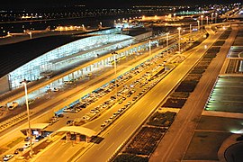
Tehran has three airports, Mehrabad International Airport, Imam Khomeini International Airport, and Ghal'eh Morghi Airport.
The Iranian capital is highly dependent on private cars, buses, motorcycles and taxis, making it one of the most car-needy cities in the world. In 2001, a metro was inaugurated that had been planned since the 1970s and has five lines. The city has the Tehran Railway Station, whose opening dates back to 1930.
Airports
There are 3 main airports operating in Tehran, which are Mehrabad International Airport, Imam Khomeini International Airport and Ghal'eh Morghi Airport.
Mehrabad airport is an old airport located west of Tehran that also has a dual use and also functions as a military base. This airport is mainly used for domestic flights and local charter flights.
Imam Khomeini International Airport is located 50 kilometers south of the city and serves as the main airport for international travel.

Airlines stationed at Mehrabad Airport
Entrance to Khomeini Airport

Facilities within Khomeini Airport

Maintenance aircraft at Mehrabad Airport.

View of an Airbus 350 aircraft at Mehrabad Airport


.jpg)
Education and research
Tehran is the largest and most important educational center in Iran. Today there are about fifty major universities in total in Greater Tehran. Since the establishment of Darolfonún in the mid-19th century, Tehran has amassed a large number of institutions of higher learning. Some of these institutions have played fundamental roles in the development of Iranian political events. The University of Tehran is the oldest state university and is the largest in Iran. Samuel Jordan, after whom Jordan Avenue in Tehran was named, was also one of the founding pioneers of the American College of Tehran. Tehran is also home to the country's largest military academy, as well as several religious colleges and seminaries. The city houses the National Library of Iran.
Culture
Architecture
Tehran's oldest architectural monuments are from the Qajar Dynasty and Pahlavi Dynasty eras. Although, considering the Greater Tehran area, monuments dating back to the Seljuk Dynasty era also remain; notably the Toqrol Tower in Rayy. There are also remains of the Rashkan Castle, which dates back to the former Parthian Empire, of which some artifacts are in the National Museum of Iran; and the Bahram Fire Temple, which remains from the Sasanian Empire.
For a long time, Tehran had only a small population until the late 18th century century, but it began to play a larger role important in Iranian society after being chosen as the capital of the country. Despite constant earthquakes during the Qajar Dynasty period, some historic and iconic buildings have managed to remain standing since that time.
The city of Tehran has the most modernized infrastructure in all of Iran. However, the gentrification of old neighborhoods and the demolition of several culturally significant buildings have caused much concern in recent years.

Hasanabad Square

View of Teheran Theatre.
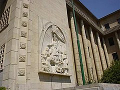
Palacio de Justicia de Tehran

Police House located in the National Garden of Tehran

Cosaca House in the National Garden of Tehran


Sports
Tehran was the host city of the 1974 Asian Games.
Religious centers

- Hoseiniye Ershad
- Soltaní Mosque, built by Fath Ali Shah
- Atiq Mosque, built in 1663.
- Mosque Mo'ezz o-dowleh, built by Fath Ali Shah.
- Hach Seyed Azizollah Mosque, built by Fath Ali Shah.
- Al-Yavad Mosque, Iran's first modernist design mosque.
- The ancient Sepahsalar mosque, another prominent mosque in the Qajar era.
- The new Sepahsalar mosque.
- Mosque Filsuf o-dowleh, it was Qayar.
- Moshir mosque ol-Saltaneh Mosque, was Qayar.
- Mosque Mo'ayyer Mosque was Qayar.
- Mausoleo Shahr Banu.
- Mausoleum Yavanmard-e Qassab an almost mythical pre-Islamic hero.
- Dozens of holy places, hundreds of years old, including that of the Imánzade Saleh.
- Dozens of traditional Saqqajané prayer sites.
- Many traditional Tekye sites for their morning ceremonies by Husayn ibn Ali.
- The cemetery Ebn-e Babuyéwhere many famous Iranians such as Tajti and Ali Akbar Dehjodá are buried.
- The Zahiroddoulé cemetery, where many Iranian art and culture stars such as Irach Mirzá, Mohammad Taqí Bahar, Forugh Farrojzad, Abolhasan Sabá, Ruhollah Jaleghí, and Darvish Jan are buried.
- Tomb of Kordan, of the Selyuqui era, Karach.
- Maydanak tomb, centuryXIIIKarach.
- The Polish cemetery north of Tehran in the British garden of Gholhak, where many allies of World War II are buried.
- The other Polish cemetery (Catholic cemetery) in Dulab, south of Tehran.
- Orthodox cemetery, in Dulab where the tomb is to the unknown Russian soldier, who has a red star over it.
- Tower of Silence (Dajme-ye gabrha), sit on the Moshiryh road behind the cement factory in the 7th unit of Tehran. It's circular.
- Torre Nagharejané, located on the mountain of the same name (Nagharejané) in the Haftdastagh district, next to the Aminabad road. Her antiquity is unclear but there are stories of the Seljuki era that speak of her. The tower is the tomb of a Selyuqui sultan. Under the tower you can see other historical ruins the (dome Einanj). This place is a real cemetery and was used in the early years of the Islamic era in Persia.
Churches

- Cathedral of San Sarkis
- Surep Georg, built in 1790.
- Church of San Judas Tadeo, built in 1808.
- Tatavus, from the Qayar era.
- Enyilí, built in 1867.
- Assyrian Church.
Twinned cities
 Havana, Cuba (2001)
 Pretoria (South Africa) (2002)
 Caracas (Venezuela) (2005)
 Beijing, China (2006)
 Minsk (Bielorrusia) (2006)
 La Paz (Bolivia) (2008)
 Dusambé (Tajikistan)
 Seoul (South Korea)
Image gallery

View of Tehran from the Milad Tower.

View of Tehran from Shirpala.

Bazaar of Tehran.
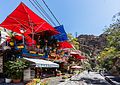
Restaurants in the Darband district.

Mansion Masoudieh.

Bazaar of Tehran.

Inside the wind tower, Golestan Palace.
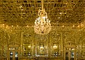
Interior of the Golestan Palace.

Marble Throne, Golestan Palace.


Contenido relacionado
Macaronesian
Trondheim
Saint John of Aznalfarache