
Taurus Mountains
The Taurus Mountains (Turkish: Toros Dağları) are a mountain range located in Cilicia, southern Turkey. from Lake Egridir in the west to the upper reaches of the Euphrates in the east, forming an arc that runs parallel to the Mediterranean Sea, which forms the southern limit of the Anatolian plateau. To the east, they divide into a branch (Antitaurus) which continues northeast to the headwaters of the Euphrates, and another branch (Eastern Taurus) which passes south of Lake Van and north of the Tigris, and is crossed by the Euphrates in their descent into Syria.
The mountain range has several peaks higher than 3000 meters. The pass known in ancient times as the Cilician Gates crosses the central part of the Taurus Mountains, north of the city of Tarsus.
The limestone has eroded into karst landscapes of waterfalls, underground rivers, and some of the largest caverns in Asia.
The Taurus Mountain range forms a climatic barrier between the Anatolian plateau, with a continental climate, and the southern coast, with a Mediterranean climate.

Gallery

Pico near the village of Akoren

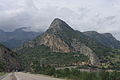
Aladaglar Mountains Views from Aladağ in Adana

The Taurus Mountains from Belemedik, Adana

Divrik Mountain summit of 2457 m, view from the Aciman hill in Aladag, Adana. (coordinates of Divrik N 37°48′38′′′ E 35°24′20′′′′′′.
Colina in Durmuslu; Kozan, Adana

mountains near the village of Güzelim, in Tufanbeyli, view at sunset

View of Seydişehir and the Taurus Mountains from Ilıca

Partial view of the Çatalan reservoir and the Tauro rn Karayusuflu mountains, Sarıçam - Adana


Geology
The Taurus Mountains were formed by the collision of the African and Eurasian tectonic plates. The predominant underlying rock is limestone. In the Aladar and Bolkar mountains, limestone has eroded to form karst landscapes of waterfalls, underground rivers and some of the largest caves in Asia. The Manavgat River originates from the southern slopes of the Beydaglari Range.
Climate
The mountains have a Mediterranean climate, with dry summers and rainy winters. Temperatures vary with elevation, with warm winters on the lower coastal slopes and cold winters in the high mountains and inland.
Flora and fauna
At lower elevations, the predominant vegetation is evergreen oak and Turkish pine (Pinus brutia) woodland and woodland, and areas of maquis scrub. Above 1200 meters of altitude there are montane forests of black pine (Pinus nigra), Lebanon cedar (Cedrus libani), Taurus fir (Abies cilicica ) and juniper (Juniperus spp.). The high peaks are home to alpine meadows.
History

Prehistory and early Roman period
The bull was commonly the symbol and representation of the ancient storm gods of the Near East, hence the bull Taurus and hence the name of the mountains. The mountains are a site of many ancient temples of storm gods. Torrential thunderstorms on these mountains were considered by the ancient Syrians to be the work of the storm god Adad to cause the Tigris and Euphrates rivers to swell and flood and thus thus fertile their land. The Hurrians, probably the creators of the various ancient Near Eastern storm gods, were a people that modern scholars place in the Taurus Mountains at their probable earliest origins.
A Bronze Age archaeological site, where early evidence of tin mining was found, is located at Kestel. The pass known in antiquity as the Cilician Gates crosses the mountain range north of Tarsus.
The Amanus Range in southern Turkey is where the Taurus Mountains rise when three tectonic plates meet. The Amanus is a natural border: the west is Cilicia, the east is Syria. There are several passes, such as the Amanian Gate (Bahçe Pass), which are of great strategic importance. In 333 B.C. In the battle of Issus, Alexander the Great defeated Darius III Codomanus on the hills along the coast between these two passes. In the Second Temple period, Jewish authors seeking to more precisely establish the geographical definition of the Promised Land, they began to interpret Mount Hor as referring to the Amanus range of the Taurus Mountains, which marked the northern limit of the Syrian Plain.
Late Roman Period to Present
During World War I, the German and Turkish railway system across the Taurus Mountains proved to be a major strategic objective of the Allies. This region was specifically mentioned as a strategically controlled target scheduled for surrender to the Allies in the Armistice, which ended hostilities against the Ottoman Empire.