
Talampaya National Park
The Talampaya National Park is located in the center-west of the province of La Rioja in Argentina between the departments of Coronel Felipe Varela and Independencia. It was created with the aim of protecting important archaeological and paleontological sites in the area and occupies 213,800 ha (according to the National Parks Administration). It is adjacent to the Ischigualasto Provincial Park located in the province of San Juan, also known as Valle of the moon. In 2000 Unesco declared both parks as Cultural and Natural Heritage of Humanity in America. The name Talampaya corresponds to the extinct Cacán language and would mean: dry river of felling.
General characteristics


The low mountain ranges of western Rioja expose erosive processes that form straight canyons and high walls. Its landscape, flora and fauna are characteristic of the biome of Mt. It is the result of tectonic movements, to which water and wind erosion have been added for millennia in a desert climate with large thermal amplitudes, intense heat during the day and low temperatures at night, with torrential rains in summer and strong winds in spring. The average height of the terrain is around 1300 m s. no. m..
Climate
The climate is continental and almost extreme temperatures prevail both in summer and winter. Sensible temperature variations during the day are frequent, and with respect to night the differences are notorious. Summers are warm, with highs that can exceed 50 °C in the sun, and winters with absolute lows of -7 °C to -9 °C. The months with probability of frosts are from May to October. Solar radiation is intense. The winds blow throughout the year and the most frequent are those from the northwest, west, and southeast quadrants, the Zonda wind being one of the most violent. Low humidity is characteristic both in summer and winter, except when torrential rains often accompanied by hail occur. These are temporary and most often occur in summer. In winter there is usually some isolated snowfall. The annual average rainfall in the region is 150 to 170 mm.
Flora
It is found mainly in the bushy vegetation typical of desert areas such as sparse, cane brava, stunted and broom, which has practically no leaves and photosynthesis is carried out in its green stems. The jarillas of glossy and resinous foliage, and the pitch, covered with yellow flowers in spring. You can also see some cacti such as the puquis and various cardones, as well as the chilca, a shrub from the mountain slopes that is endemic to La Rioja, San Juan and San Luis. On the other hand, in the temporary channels open forests of large carob trees unfold, in Los Cajones, drinking molles.
Wildlife

120 species have been documented in the fauna of the national park, of which 16 belong to insects and 104 to vertebrates, of which the gray fox, the black-footed squirrel, and the black lark deserve to be highlighted, which they are common in the immediate vicinity of the entrance to the area. The high reddish walls are used as posts by various birds of prey, such as the Andean condor, the Moorish eagle, and the peregrine falcon. They are also the home of rodents such as the chinchillón. Among the shrubs of the sandy pockets it is possible to see some endemic species of Argentina, for example the sand cock, the reddish canastero, the brown cacholote. Among mammals, the pichiciego, a small armadillo with underground habits. Some brown-furred guanacos can also be seen in the national park, characterized by their necks being slightly longer than normal. Other species present are Andean suris, quirquinchos, hares, vicuñas, pumas, maras, red foxes and reptiles such as pythons and rabbit vipers.

Geology
Talampaya shares the Triassic geographic basin with Ischigualasto. All this geological basin is considered one of the most important paradises in geological material of the Argentine Republic. The park has rocks that document the evolution of the planet for more than forty-five million years, being, for example, a witness to the division of the supercontinent Pangea more than 250 million years ago.
The Talampaya formation is made up of an agglomeration of brownish-red rocks. The walls and the canyon of the Talampaya River were eroded by the wind and water, giving them curious shapes. Collective mortars, remains of indigenous houses and petroglyphs of great antiquity are added to the landscape. The strata are mainly made up of sandstone deposited by alluvial fans that came down from the edges of the basin. This rock, due to wind erosion over millions of years, with its multi-colored sandstone and clay, acquired various shapes. Many of these forms have their own names such as: the Friar, the Wizard King, the Cathedral, the Chessboard, the Needles, the Manger and the Castle. In the area known as Ciudad Perdida, you can see the splendor of the geoforms of Talampaya.
In the basin there are five formations represented by a sedimentary cycle that begins with red beds sediments (Tarjados formation), which are followed by gray sediments (Ischichuca formation), then green layers appear (Los Rastros formation); They are followed by gray formations (Ischigualasto) and finally the red beds of the Los Colorados formation.
Paleontology
The park is an important paleontological site, it is a site of great importance due to its abundant wealth of fossils. Among the fossils discovered is Lagosuchus talampayensis, one of the first archosaurs to inhabit Earth, 250 million years ago, at the beginning of the Triassic. Fossils of turtles dating back 210 million years were also found, such as the Palaeocheris talampayens. Thanks to a long series of fossil animals unknown to paleontology, one of the most interesting studies in paleontological science is being completed: how and when the first dinosaurs arose, in addition to increasing knowledge about the mammalian reptiles from whose basic trunk they later emerged. the mammals.
Indigenous peoples

In the area, human occupations date from the year 120 and 1180 of our era, where important engravings and paintings discovered on stones and ceramics were found, which express a harmonizing fusion between nature and culture. The most important nucleus where the traces of this ancestral culture can be observed corresponds to the area called Los Pizarrones, which is located on the bed of a temporary stream tributary of the Talampaya River, in a flat and smooth sector of rock about 15 m long covered with sculpted engravings (petroglyphs) several centuries before the conquest.
Remains of houses and stone walls, fragments of baked clay and lithic material from the making of rock elements were also found in the area. It is to be assumed that in those times, some thousand years ago, the climate would be somewhat more humid and the greater abundance of permanent water, vegetation and fauna would have facilitated the installation of stable human groups and the opportunity for the development of their artistic manifestations., rock and craft.
History
The vast basins remained virtually unknown due to their isolation. Only the construction of the highway in the 1970s, which connects Patquía with Villa Unión, allowed the entry of motorized vehicles. The objective was to preserve an interesting sample of the mountain environment, archaeological and paleontological sites in a framework of impressive scenic beauty. The canyon and its access were first built by the engineer Werner Lorenz, a German geodesist based in Villa Unión.
Its diffusion as a natural wonder is due to Federico Kirbus, journalist, writer, researcher, who from 1977 began publishing illustrated articles on the formations of Talampaya and Ischigualasto, notes that thus began to attract the first independent tourists.
Creation
Through Provincial Law No. 3509 sanctioned on May 16, 1975, the province of La Rioja created the Talampaya Provincial Park.
By Law No. 6192 enacted on August 1, 1996 and promulgated by Decree No. 1334/1996, the province of La Rioja ceded jurisdiction over the Talampaya Provincial Park to the National State:
Article 3: The province of La Rioja, assigns to the National State for its incorporation as a National Park into the system of National Law No. 22.351, as established by it in Articles 4o, 5o and 6o, jurisdiction over the area covered by the following limits:
(a) TALAMPAYA PROVINCIAL PARK: An approximate area of 215,000 hectares (...)
Law No. 6192 was modified by Law No. 6224, enacted on September 19, 1996 and promulgated by Decree No. 1335/1996.
National Law No. 24846, enacted on June 11, 1997 and promulgated on July 10, 1997, accepted the assignment and created the Talampaya National Park:
ARTICLE 1-Accept the assignment of jurisdiction and dominion by the Province of La Rioja to the national State through article 3 of Provincial Law No. 6192, sanctioned on 1 August 1996 and promulgated by Decree No. 1334/96 and its amendment No. 6224, sanctioned on 19 September 1996, promulgated by Decree No. 1335/96, on an area of approximately DOSCIENTAS QUINCE QUINCE No 26 kilometer 85 (1 equal to latitude 30o 12'06", and longitude 67o 40'32"), a line heading north that reaches the Portezuelo Amarillo, located in the Sierra de Sañogasta (2 equal latitude 29o 36' 00" and longitude 67o 40' 32"), from there heading west following the course of the Rio de la Caída, until its departure from the Sierra de los Tarjados (3 equal latitude 30' From there the line takes direction South, following the foot of the Sierra de los Tarjados until you find the South boundary of the Campo de Pagancillo (4 equal latitude 29o 44' 30" and length 67o 52' 30"). From this place the line takes direction West and following the southern border of the Campo de Pagancillo arrives to the Río Bermejo (5 equal latitude 29o 40' 00" and longitude 68o 16' 30") from there the line goes south to give with the Cerro Rajado Summit. From this place the line continues southeast to reach the path that comes from Usno passes through Los Baldecitos and empalma with the Provincial Route No. 26. From this place the line takes direction Northeast and following the path above described arrives to the Provincial Route No 26 closed the polygonal at the Astronomical Point 53 (1).
On November 14, 2001, the Management Plan for the Talampaya National Park -phase 2- was approved.
Administration
By resolution no. which is headed by a designated intendant, who reports to 4 departments (Administration; Works and Maintenance; National Park Rangers; Conservation and Public Use) and 2 divisions (Office and Desk for Entrances, Exits, and Notifications; Human Resources and Training). The administration is based in the town of Villa Unión.
Access and tourism
The Talampaya canyon is located 59 km from Villa Unión, 150 km from Patquía and 216 km from the city of La Rioja.
The Talampaya National Park is crossed by National Route No. 76, which connects the western towns of La Rioja with the city of Patquía in the same province. The section of Provincial Route No. 26 between Villa Unión and Los Baldecitos —the latter town on the border of the provinces of La Rioja and San Juan— crosses the national park. The reporting center is located 14 km up this route, veering off to the northeast.
In the place where the information center is located, which has toilets and a bar, the tours of the Talampaya canyon begin where you can see various samples of archaeological heritage, particularly in the Puerta de Talampaya and Los Cajones sectors. The Lost City is one of the most attractive tourist sites, due to its panoramic beauty and the strange geoforms that can be seen there. To access this circuit you must request authorization from the park ranger.
Inside the park you can see: the dry bed of the Talampaya River, where dinosaurs lived millions of years ago; remains of native peoples, such as the petroglyphs of the Puerta del Cañón; a botanical reserve garden for autochthonous flora; natural walls up to 145 m high with geological formations carved into the red sandstone; fauna of the region.
Image gallery

Rock formation called The Monk.

Rock formation called Totem.
Rock formation called The Turtle.

Landscape from the tourist route to the canyon.

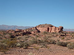
View of the national park.

Petroglyph at the entrance of the canyon.

Talampaya Canyon Illusion


Contenido relacionado
Portal:Mexico/Main article
El Sabinar (Murcia)
Plitvice Lakes National Park
Lake constance
Ilamatepec Volcano