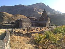
Syunik' Province
Syunik' is one of the provinces of Armenia. Its capital is Kapan. It has an area of 4,506 km² and a population of 145,000 (1991). It borders to the north, northeast and east with the Security Zones in Azerbaijan (Kashunik and Kovsakan provinces), to the south with the Aras River forming a 35 km border with Iran (Azarbaijan-e Gharbi province), to the west with Azerbaijan (exclave of the autonomous Republic of Nakhchivan, which it separates from Azerbaijan), and to the northwest with the province of Vayots Dzor.
Geography
Syunik is located in southern Armenia, between the Nakhchivan Autonomous Republic to the west, which belongs to Azerbaijan, and the disputed region of the Republic of Upper Karabakh, to the east. To the north it is bordered by the Armenian province of Vayots' Dzor, and to the south the Aras River separates it from Iran.
The current territory occupies the same space as the historical province of Syunik, ninth of the kingdom of Armenia between the years 189 a. C. and 428 d. c.
The entire region is mountainous, covered for the most part by a thick green forest, the largest in all of Armenia, for the most part devoid of forests. The dominant Zangezur Mountains separate the province from the Nakhchivan Autonomous Republic to the west. The most important peaks are Mount Kaputjugh, 3,905 m, and Mount Gazanasar, 3,829 m.
Many forests are protected by the Government, for example Arevik National Park and Shikahogh State Reserve, 10,000 ha which escaped massive deforestation from the post-Soviet era, and the nature sanctuaries of Boghakar, Goris, Plane Grove, Sev Lake and Zanzegur.
The most important river is the Vorotán, which rises in the north of the province, in the Garabagh mountains and flows to the south and southeast, where the Spandaryán reservoir has been built. From this reservoir a tunnel has been built, which was completed in 2003, to the Kechut reservoir, on the Arpa river, 23 km away, and from this reservoir to Artsvanist, 49 km, on Lake Sevan, in 1981, to supply this lake with water due to the drop in level of the last decades. The Vorotán River then continues to Sisian (15,000 inhab.) in the center of province and from here it heads east and enters Azerbaijan.
Three hydroelectric power plants have been built along the Vorotán River as part of the Vorotán Hydroelectric Complex (ContourGlobal Hydro Cascade), made up of the Spandaryán, Shamb and Tatev power plants.
Other important rivers are the Voghji river, in the south center, which passes through the cities of Kajarán and Kapán, where it receives the Vachagán, and further south, the Tsav river. All the rivers flow into the Aras River.
The southern border of the country is marked by the Aras River, which separates it from Iran.
Population
According to the 2011 census, Syunik had a population of 141,771 (69,836 men and 71,935 women), about 4.7% of the total for Armenia. The urban population is 95,170 inhab. (67.13%), spread over 7 cities, the largest of which is Kapán, with 43,190 inhab. It is followed by Goris, Sisian, Kajarán, Meghri, Agarak and Dastakert. The rural population is 46,601 inhabitants spread over 102 rural communities, of which Shinuhayr is the largest (2,865 inhabitants in 2011). Another rural town notable for the presence of megaliths is Karahunj, with 1,365 inhabitants, where the prehistoric archaeological site of Zorats Karer is located.
Syunik is populated entirely by ethnic Armenians of the Armenian Apostolic Church. The headquarters of the Diocese of Syunik is located in the Cathedral of Saint Gregory, in Goris, headed by Fr. Zavén Yazichyán.
History
Bagratid Dynasty
The principality had its own dynasty, ruled by a branch of the Bagratids with petty minor princes from one or more previous dynasties perhaps of Persian origin. Prince Vasak III (c. 800) came under attack from the Emir of Manazkert, Sevada, who established a garrison at Chalat, in the Dzoluk district, and called to his aid the Persian revolutionary chief Babek, who married a daughter of the prince. On Vasak's death (821) Babek inherited the country. The country revolted and Babek razed it but harassed by Muslims and Armenians he abandoned it and Vasak's sons, Felipe and Sahak regained power, the former ruling Eastern Siunia, with the districts of Vaïots, Tzor and Balq (Goucha), and the Second, the Western one also known as Gelarquniq, with its capital in Khoth.
Late 10th century
Local dynasties disappeared during Babek's short-lived rule. In 826, Sahak allied himself with his former enemy the Kaisite emir of Manazkert, Sevada, against the Caliphate governor, but was defeated and killed by him at Kavakert; however, his son Grigor-Sufan succeeded him without major problems as prince of Western Siunia. In the Eastern part, Felipe died on August 10, 848 and was succeeded by three sons together: Babgen, Vasak-Ichkhanik and Achot. Babgen fought and killed Grigor-Sufan (c. 849, 850 or 851) but Babgen died soon after (851) and Vasak-Ichkhanik (Vasak IV) succeeded him living in peace with Vasak-Gabor who had ascended the throne of Western Siunia instead of his father Grigor-Sufan. Nerseh, brother of Babgen, led (851?) an expedition to Aghuania defeating and killing Prince Varaz-Terdat (of the Persian Mihrakane dynasty of Aghuania) at Morgog. An envoy of the Caliph, Bogha al Kabir, devastated Armenia and Aghuania in these years, and sent a prominently to Eastern Siunia where Vasak IV ruled with his brother Achot.
The Siunians made themselves strong in the fortress of Balq, but Vasak fled to Kotaiq, but pursued he had to pass to the region of Gardman on the eastern shore of Lake Sevan, whose prince (ishkhan) Ketridj or Ketritchn betrayed him and handed over to Bogha (859). Achot was also taken prisoner (859). But Bogha entered Gardman and took Kertridj prisoner without thanking him for his service. He then went on to [Outi] where he captured the prince of Sevordiq, Stephannos Koun. All these regions tried to be controlled by the caliphate, and for this Bogha had the city of Chamkor on the Kurá river repopulated by Muslims, which together with Barda'a and Gandja was destined to monitor the region. In 862, the imprisoned princes were released by order of the new caliph and were able to return to their domains in exchange for recognition of Islam (which they withdrew as soon as they arrived in their homeland). Not long after, the West Siunian prince Vasak-Gabor married a daughter of the Bagratid Achot the Great, named Miriam, and received the title of Ishkhan of the Siunians from Achot in the Caliph's name. He was succeeded by his son Grigor-Sufan II (887-909).
Beginning of the Orbeliani dynasty
About 887 the East Siunian prince Vasak IV died and was succeeded by his brother Achot who died c. from 906. Vasak IV's son Sembat, who received the fiefdom of Valots-Tzor and Chahaponk (Djahuk) ruled from 887 to a date after 920; rebelled (903) against the Bagratid Sembat I to whom he refused to pay tribute, and for this he was attacked by the prince of Vaspurakán Sargis-Achot, and Sembat submitted and was pardoned (he married the sister of the prince of Vaspurakán) receiving the city and district of Nakhchivan, seized in 902 from the Kaysites. The prince of Vaspurakán should not have agreed to this ceding of a territory close to his domain that he could legitimately expect and a few years later he allied himself with the Sayid emir Yusuf against Eastern Siunia and together they invaded the country. Sembat took refuge in the Erendchak fortress (today Alindja northeast of Najichevan) and Yusuf became master of Eastern Siunia. Sembat nevertheless asked his brother-in-law Khatchik-Gagik for refuge and he granted it. In the same year 909 the prince of West Siunia Grigor Sufan II submitted to the emir Yusuf in Dwin.
Only the Byzantine movements and the withdrawal of the Sayids will allow them to regain the throne some time later. Sembat, with his three brothers Sahak, Babgen and Vasak, ruled again. Also in Western Siunia Sahak, Achot and Vasak, brothers of Grigor-Sufan II, ruled the country, after which the western dynasty would disappear subjected to the territory by the Muslims. The eastern part was divided: Sembat, who had the title, governed the western part of Eastern Siunia with the Vaïots-Tzor, bordering on Vaspurakán; Sahak, the eastern part to the Hakar river; Babgen the district of the Balq; and Vasak an indeterminate territory (he died in 922).
Dominion of the Emir of Azerbaijan
The emir of Azerbaijan, Nasr, treacherously captured Babgen and Sahak in Dwin, but upon invading the domains of Sembat, he faced him energetically and rejected him and even obtained the freedom of his brothers. Sembat was succeeded by his son Vasak, and Sahak by his son Sembat. Vasak received the royal title from the Muslims towards the end of his reign which lasted until 963; then the throne passed to his nephew Sembat (963-998) who was recognized as king by the emirs of Tauris and Arran. He married the princess of Aghuania, Chahandoukht. On his death he was succeeded by Vasak (c. 998-1019) and on his death by two nephews (sons of a sister and a prince named Achot from another family branch) named Sembat and Grigor (1019-1084). The latter married Princess Chahandoukht, daughter of Sevada of Aghuania. The two princes, with no more succession than a daughter of Grigor named Chahandoukht, adopted the prince of Aghuania, Seneqerim Ioan, who ruled both territories from 1084, dying in 1105. His son Grigor of Siunia and Aghuania succeeded him, who ruled until 1166 when the country was conquered by the Seljuk Turks.
The Orbeliani dynasty, one of whose members wrote an important history of the country, ruled Siunia in the time of Timur (Tamerlane) as a vassal.
Modern Period
In September 1920, Armenia ceded the region of Siunia and Zangezur and Upper Karabag (to the East) to Azerbaijan. The military forces in the region did not accept the decision and proclaimed the autonomous Republic of Syunik. After the proclamation of the Armenian Soviet Socialist Republic in 1921, Syunik, partly occupied by the Azerbaijanis, proclaimed its independence as the Republic of Mountainous Armenia, but it only covered part of Upper Karabag (south of Zangezur) and Western Siunia and Oriental had been occupied. After some time of resistance the authorities of the Republic fled to Iran.
Culture
Fortresses and Archaeological Sites
- Zorats Karer, prehistoric archaeological site, which many scientists, including the Armenian Paris Herouni, consider to be a prehistoric astronomical observatory.
- Baghaberd, fortress of the centuryIV
- Vorotnaberd, fortress of the centuryV
- Meghri, fortress of the centuryXI
- Halidzor, fortress of the centuryXVII
- Khndzoresk artificial caves.
- Petroglyphs of Ughtasar, near Sisian
- Caves of Khndzoresk, a mountain inhabited until the 1950s, near Goris.
Churches and monasteries
- Monastery of Surp Hovhannes (San Juan) of Sisian, of 690
- Monastery of Tatev, centuryIX
- Monastic Complex of Vorotnavank, centuryX
- Monastery of Vahanavank, centuryX
- Monastery of Bgheno-Noravank, centuryXI
- Monastery of Tatevi Anapat, of the centuryXVII
Communities and settlements
As of February 2017, there were 72 administrative communities in Syunik, of which 6 were urban and 66 rural.


