
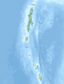
Sunda Strait
The Sonda Strait (Indonesian: Selat Sunda) is a sea strait separating the Indonesian islands of Java and Sumatra. It connects the Java Sea with the Indian Ocean.
The name of the strait comes from Sunda, which means the country of the Sundanese, the people who inhabit the western part of the island of Java. Sunda has also given its name to the Sunda Islands, a name traditionally applied to a part of the Indonesian archipelago.
Geography
The strait extends along a generally south-west/north-east oriented axis. Its minimum width is 24 km between Cape Tua, in Sumatra, and Cape Pujats, in Java. It is about 30 km wide at its narrowest, in the north-eastern end, but it is a short section about 30 km long, but then it opens up to 100 km for another 100 km long.
The strait is dotted with a number of small islands, including Sangiang, Sebesi, Sebuku, Panaitan, and the islands of Krakatoa: Krakatoa, Lang (Panjang or Rakata Kecil), Verlaten (Sertung), and Anak Krakatoa. Many of them (including Sebesi and Panaitan) are of volcanic origin. Anak Krakatoa is the product of the 1883 eruption.
The strait is deep at its western end, but at its eastern end, the minimum depth is 20 meters. It is not an easy strait for sea navigation, due to its many sandbars, strong tidal currents, and many oil platforms in the vicinity of Java.
According to a hypothesis proposed by the archaeologist Daid Keys and the geologist Ken Wohletz, the strait that connects the Java Sea with the Indian Ocean would have existed since the year 535, due to an eruption of Krakatoa. This would have left a caldera 50 km in diameter, separating the islands of Java and Sumatra. However, this hypothesis is not favored by most geologists and historians, who tend to consider that the Sonda Strait is much older, and its existence is due to a rift rather than a volcanic caldera.
Islands in the Strait
Bays
- Lampung Bay, Sumatra
- Semangka Bay, Sumatra
- Welcome Bay, Java
Gallery of important channels nearby

Gulf of Mannar

Cocos Strait, Duncan Pass and other Indian Channels

The Cocos Strait is located at the northern end of the Andaman Islands, in the red square
Canal de los Diez Grados

Front of the Canal de los Diez Grados
Strait of Malacca

Singapore Strait
Probe Strait

Lombok Strait

South China Sea, Strait of Malacca, Gulf of Thailand, Sea of Sulu, Sea of Célebes


History
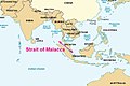
For centuries it was an important maritime route, especially when the Dutch East India Company passed through its waters its merchandise coming from the Moluccas and going to Europe or India, as a gateway to the islands of the Spices (1602-1799). As one of the main passages from the South China Sea to the Indian Ocean (the other being the Strait of Malacca), the Sunda Strait, despite the dangers due to narrowness and rocks, is much shorter than the Strait of Malacca, and consequently the ships ran less risk of attack by pirates.
The islands of the strait and the surrounding regions of Java and Sumatra were devastated by the eruption of Krakatoa in 1883, mainly due to intense ash and pumice fall and huge tsunamis caused by the volcano collapse. The eruption drastically altered the topography of the strait, with between 18-21 km³ of ignimbrite being deposited in an area of 1.1 million km² around the volcano. Some areas have never been reoccupied (such as the coastal region of Java now incorporated into the Ujung Kulon National Park), but most of the coast is now very densely populated.
Today, the strait's narrowness, shallowness, and lack of sea charts make it unsuitable for many large modern ships, and it has been relegated as a shipping route in favor of the Malacca Strait, between Sumatra and the Malacca Peninsula..
The Battle of Sonda Strait
On March 1, 1942, the Battle of Sunda Strait—part of the Great Battle of the Java Sea—was fought in its waters, when the Allied cruisers HMAS Perth and USS Houston encountered a Japanese amphibious landing force near Bantam, commanded by Admiral Kenzaburo Hara, which included aircraft carriers, three cruisers and ten destroyers. Allied cruisers were sunk, but a Japanese minesweeper and transport ship were also sunk by friendly fire.
Bridge project
In the 1960s proposals were made to build a bridge across the Sunda Strait, and new proposals emerged in the 1990s. A new plan was announced in October 2007, which would involve using the islands of Ular, Sangiang and Prajurit to create a four-part suspension bridge, with a length of about 26 km, carried out at about 70 meters above sea level and with a maximum span of 3 kilometers, almost 50% longer than the current record, the Great Bridge of Akashi Kaikyō.
Contenido relacionado
Volcanic cone
Fortin Municipality
Infant