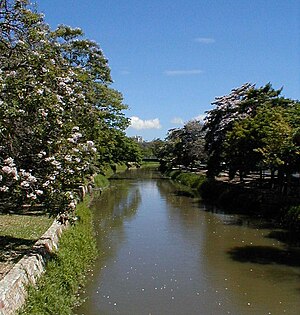
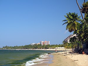
Sucre state
| Historical population of the Sucre State | ||
|---|---|---|
| Year | Pob. | ±% |
| 1873 | 62 181 | - |
| 1881 | 78 459 | +26.2% |
| 1891 | 92 030 | +17.3% |
| 1920 | 150 211 | +63.2% |
| 1926 | 216 476 | +44.1% |
| 1936 | 262 344 | +21.2% |
| 1941 | 291 452 | +11.1% |
| 1950 | 333 607 | +14.5% |
| 1961 | 401 992 | +20.5% |
| 1971 | 469 004 | +16.7% |
| 1981 | 585 698 | +24.9% |
| 1990 | 679 595 | +16.0% |
| 2001 | 788 161 | +16.0% |
| 2011 | 896 291 | +13.7% |
| 2017 | 1 059 500 | +18.2% |
| Note: The table shows the total population of State Sucre based on official censuses of: Venezuelan Census of 1873 Venezuelan Census of 1881 Venezuelan Census of 1891 Venezuelan Census of 1920 Venezuelan Census of 1926 Venezuelan Census of 1936 Venezuelan Census of 1941 Venezuelan Census of 1950 Venezuelan Census of 1961 Venezuelan Census of 1971 Venezuelan Census 1981 Venezuelan Census 1990 Venezuelan Census 2001 Venezuelan Census of 2011 Population estimates (from 2017) since the last census. | ||
Sucre is one of the twenty-three states that, together with the Capital District and the Federal Dependencies, form the Bolivarian Republic of Venezuela. Its capital is Cumana. It is located in the northeastern region of the country, bordering the Caribbean Sea (Atlantic Ocean) to the north, the Gulf of Paria to the east, Monagas to the south, Anzoátegui to the southwest, and the Gulf of Cariaco to the west. It is made up of 15 municipalities divided into 57 parishes. It owes its name to the Grand Marshal of Ayacucho Antonio José de Sucre.
History
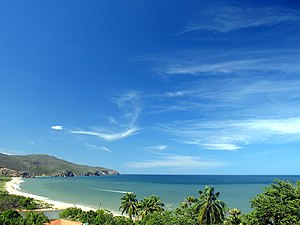
This Venezuelan State has great historical importance, because it was the first Venezuelan land touched by the Genoese navigator, Christopher Columbus. This, impressed by the greenery of the flora, the coasts and the crystal clear water of its beaches, called the place “Tierra de Gracia”.
The state capital is Cumaná, which was founded by Gonzalo de Ocampo in 1521, although Franciscan missionaries began to populate it in 1515. In 1530 it was hit by an earthquake, so it had to be rebuilt. On July 2, 1591, King Philip II of Spain granted Cumaná the title of city.
In 1639, conflicts appeared in the Valley of Cumanacoa, since the well-known conquistador Juan de Urpín incorporated Cumanacoa into the territory of his ephemeral Governorate of Nueva Barcelona and obtained authorization to found a colony there. On February 18, 1643, he founded the colony and gave it the name of Santa María de Cumanacoa. Some time later the Cumanagoto tribe takes over the colony and disappears without leaving a trace of it.
In the year 1700 by order of His Majesty Felipe V sent Captain Pedro Antonio Arias and González Manso to resolve the conflict in the Valley. An armed struggle began with the indigenous Cumanagotos tribe, who maintained control of the Valley. Positioning their ships in Carúpano, the Siege of the Valley of Cumanacoa began, a conflict that lasted two years that ended up restoring order and the recovery of all the lands by the Spanish Empire, with the surrender of the indigenous tribes of the region and especially that of the cumanagotos, with which the Valley region is under the control of Captain Pedro Antonio Arias and González Manso.
King Felipe V, pleased by this service to the Spanish Empire, sent Royal orders to establish it permanently in the Valley with special powers of Governance, Justice and Commerce and to be a territory that is not subject to the Governor of the Province of Nueva Andalucía and Nueva Barcelona as well as its appointment as Señorío de San Baltazar de los Arias. In 1705, Captain Pedro Antonio Arias y González Manso founded the region of Valle with the name San Baltazar de los Arias, which would be preserved until the days of the dictatorship of General Juan Vicente Gómez.
In 1726, the Province of Cumaná was made up of Cumaná, Guayana, Barcelona, Maturín and the island of Trinidad. This organization gradually disintegrated when Guayana and Barcelona became independent provinces. In the year 1777, the Captaincy General of Venezuela was created, made up of seven provinces, among which was Cumaná.
After the events in Caracas in April 1810, commissioners entered Cumaná, a meeting was called to establish a Provisional Board that assumed the government of the Province. When Gran Colombia dissolved and José Antonio Páez assumed the presidency of Venezuela, the country was divided into 11 provinces, one of them was Cumaná. In 1853, an earthquake again destroyed a large part of the city.
In 1891 the so-called Great Bermúdez State was created, until 1898, when it finally adopted the name of "Sucre State". In 1901 the Sucre State separated from Maturín was created and in 1904 it was reintegrated into the Bermúdez State, and by 1909 the limits of the Sucre and Monagas States were definitively drawn as two separate entities.
Geography
Sucre State is located in eastern Venezuela. It limits to the north with the Caribbean Sea, to the south with the Monagas and Anzoátegui States, to the east (East) with the Gulf of Paria and to the west (West) with the Gulf of Cariaco. The name of this Venezuelan State is due in homage to the hero of independence, the Grand Marshal Antonio José de Sucre, who was born in the city of Cumaná, which is the current capital of the State.
Political-territorial division
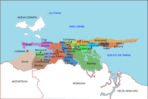
Sucre State is divided into 15 municipalities and 56 parishes.
| Municipalities of Sucre |
|---|
 Caribbean Sea Atlantic Ocean New Sparta Anzoátegui Monagas Andrés EloyBlanco AndrésMata Arismendi Bermúdez Benítez Bolívar Cajigal Acosta Freedom Mariño Mejía Montes Ribero Sucre Valdez |
Hydrography
Some of the most important rivers in Sucre State are the following:
Rivers Neverí (117 km.), which crosses the city of Barcelona, Mochima and Manzanares, the latter of 81 km. and that passes through the capital city of Cumaná. They all flow into the Caribbean Sea.
- In the Gulf of Cariaco, pour its waters one of the main rivers of the State, the Carinicuao or Cariaco which is 173 km long. Less important, but also in the same basin are Cautaro, Tunantal, Guaracayal, Compondrón, San Pedro and Marigüitar.
- In the Caribbean Sea basin, smaller rivers such as Chaure, Caribbean, Unare and Cumaná flow.
- Finally, after going 173 km, the river San Juan deposits its waters in the Gulf of Paria, like the Irapa, Aruca, Güiria, Guiramo, Grande, Manacal and Yoco.
Relief
The relief of the Sucre State is formed especially by mountainous landscapes, with some not very extensive valleys. The Turimiquire mountain range, to the southwest, shows a rough relief, with steep slopes and heights that reach 2,500 meters, while the mountainous system of the Paria Peninsula is characterized by having lower elevation hills. The Sucre coast, essentially towards the west, has all the characteristics of a sinking coast, deep, cliffs and little formation of beaches. On the contrary, towards the southeast of the entity, in the Gulf of Paria, the lands are very flat, with slopes of less than 1% and with insufficient drainage, which has turned them into marshy plains.
Vegetation
The vegetation of the Sucre State is xerophytic in the coastal and mountain areas in the rural areas located in the Coastal Cordillera, we can also find Caribbean beach plants and trees, such as coconut palms and cocoa trees. You can also find the oak, declared a State tree.
Climate
In the area of the western coast, a type of semi-arid climate is observed, registering in Cumaná an average annual temperature of 24-26 °C with a rainfall of 375 mm. As a representative area of strong climate in terms of drought and aridity conditions is the Araya Peninsula. In the southern parallel strip, a tropical rainy savannah climate is transitionally observed, which extends to the area of the coastal slope to the Caribbean Sea. In Carúpano there are average temperatures of 26-35 °C and changing rainfall of 524-1,046 mm. In the Gulf of Paria, the mean annual rainfall increases from 1,200 to more than 2,000 mm. With wooded climate. In the area of the Serranía del Interior there is a section where the high altitude tropical climate prevails.
Demographics
Populated centers
The main populations of Sucre State are the following:
- Cumana: Cumaná is the capital city and headquarters of the public powers of the state, very famous for its beaches, but it is also historically important for being the birthplace of the great Mariscal of Ayacucho, the prose independentist Antonio José de Sucre; besides being recognized for its antiquity and multiple historical sites present, as they are: The Castle of San Antonio of Eminence, The Castle Santa María de la Cabeza, The Fort
- Carúpano It was the first port of America with the old continent to have submarine cable which still remains in the house of the cable that today is the (Fundación Prosperi), as well as its historical centre that is still preserved around the Cathedral Santa Rosa de Lima temple and its majestic tourist carnival of Venezuela. Its rich culture makes it emblematic, and for its beaches, a resting place for visitors.
- Güiria: It is an important port and tourist place for the south, tourist and economical population. On its shores one of the most important gas reserves in the world was discovered.
- Cariac: This town centre is excellent to rest, eat and is also a tourist and economic port.
- Araya: Araya is located in the Sucre State, on the homonymous peninsula, is an excellent area for tourism, which is why it is one of the preferred towns of this state, white sand beaches and very friendly residents.
- Other populations: Cumanacoa, San Antonio del Golfo, Irapa, Tunapuy, Yaguaraparo, Marigüitar, El Pilar, Río Caribe, San José de Areocuar, Santa María de Cariaco, Los Altos de Santa María and Casanay.
Economy
The economy of the state is based on fishing, where it is the main fish producer in the country, indeed, almost 50% of the national production corresponds to this state and supplies 95% of the raw material to the processing industry of fish products.
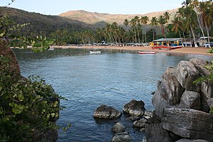
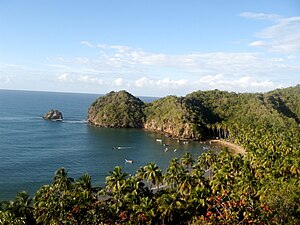
Also agriculture and tourism, but mainly the latter, one of the most touristic places in Venezuela, is the Mochima National Park, an area protected by the Venezuelan state shared between the Anzoátegui State and Sucre. This park is a unique place, in which there are a large number of islets and keys that make it up, in addition to having a great flora and fauna in its entirety. The park is a great tourist place well known by Venezuelans and beyond. In fishing, one of the states that stands out the most is the Sucre state with a large percentage, some of the states that stand out the most with this are the states of Nueva Esparta and Falcón, among others.
Resources
- Fishing resources: Atunes, pargos, sardines, among others.
- Plant resources: cocoa, coffee, sugar cane, sabila, among others.
- Forest resources: Common wood, oaks, algarrobo, among others.
- Mineral resources: Sulphur, gas, oil, Sal, among others.
- Energy resources: It has been determined that in the Sucre state there are geothermal energy sources (calculated in 150 MW as first approximation) and wind energy.
Tourism
The main tourist areas are the Mochima National Park with varied Caribbean seascapes, large beaches and small islands throughout, various species of birds, fish, shellfish and other animals. The Araya peninsula is another of several outstanding places, with a desert landscape, similar to the nearby Isla de Margarita.
The following protected islands of the Mochima National Park belong to the Sucre State:
- Caracas: Caracas del Este, Caracas del Oeste, etc.
- Los Muertos Island.
- Arapo Islands.
- Ancha Island.
- Square Island.
- Santa Marta Island.
Heritage
| Natural | Edified | |
|---|---|---|
| Gulf of Cariaco | Ateneo de Cumaná | |
| Gulf of Paria | Carúpano Athenaeum | |
| Mochima National Park | Ateneo de Güiria | |
| Araya Peninsula | Home of Cruz Salmerón Acosta | |
| Paria Peninsula | Home of the poet Andrés Eloy Blanco | |
| Pui-Pui beach | Home of the poet José Antonio Ramos Sucre | |
| Beach Fishermen | Between Playa Colorada and Arapito | |
| Playa Arapo | Castillos San Antonio de la eminencia and Santa María de la cabeza en Cumaná | |
| Playa Arapito | Convent of San Francisco | |
| Playa El Castillo | Church of Santa Inés | |
| Playa San Luis | Cathedral Santa Rosa de Lima | |
| Blue Poza Thermal Source | Saint Catherine Church in Siena | |
| Playa Pedro | Gran Mariscal Museum of Ayacucho | |
| Playa Quetepe | Contemporary Museum | |
| Playa Medina | Museum of Archaeology and History | |
| Playa Patilla | Quinal Museum | |
| Uvero beach | Municipal Museum | |
| Playa Puerto Martínez | Historic Museum of Carúpano | |
| Waters of Moses | Irapari Museum |
Politics and government
The State is autonomous and politically equal to the rest of the Republic, it organizes its administration and its public powers through the Constitution of the Sucre State, issued by the Legislative Council and published in the extraordinary official gazette of the Sucre State number 742, on November 13, 2002.
Executive Branch
It is made up of the governor of Sucre State and a group of State Secretaries. The Governor is elected by the people by direct and secret vote for a period of four years and with the possibility of re-election for equal periods, being in charge of the state administration.
Since 1989 Sucre elects a governor, until that year the governors were appointed directly from the National Executive Power, the current state government is directed by the Alm. Gilberto Pinto Blanco of the PSUV elected for the period 2021-2025.
Legislative branch
The State legislature falls on the Sucre State Legislative Council, unilateral, whose members are elected by the people by direct and secret vote every four years, and may be re-elected for two consecutive periods, under a system of proportional representation of the population of the State and its municipalities. The State has eleven regional legislators.
Sucre State Anthem
Chorus
Haughty people! emblazon the history
of your children the martial feat,
Sucre gives you its name of glory
and Ayacucho its immortal laurel.
I
Three barracks your shield prestige,
and in gold, sapphire and scarlet
from your soil appear the pleasant harmony of gifts of peace;
in the horn full of fruit,
the prodigious goodness of the soil,
and in the palm that reaches towards the sky,
Heroism, virtue, freedom!
II
The golden splendor of your beaches
is a promise of laborious bread,
how is your glorious past,
of a prodigal future well;
the most beautiful portion of the Orient
in cordial borders you enclose
and it's wild in your prodigal lands
the martial prestige of the laurel.
III
In you is united by remote grace
the laurel to the sacred olive tree,
You turned the sword into a plow
and your targets in hymns of love.
As an eminent summit culminates
From your peoples the fame will procede,
and it is the name of Sucre, flag
in perennial demand for ¡Unión!
Lyrics: Ramón David León
Music: Benigno Rodríguez Bruzual.
Contenido relacionado
Ashwoody
Eritrean flag
Navarre (disambiguation)
