Strait of Gibraltar
The Strait of Gibraltar (Arabic: مضيق جبل طارق [Maḍīq Jabal Ṭāriq]; English: Strait of Gibraltar), or simply the Strait, is the place where the natural union of two masses of water occurs: the Mediterranean Sea and the Atlantic Ocean and the separation between two continents: Europe and Africa. Even geologically, the strait represents the fissure of the two tectonic plates: the Eurasian and the African. It is one of the most important shipping lanes in the world, giving access to the Atlantic Ocean and the Mediterranean Sea, which in turn communicates with the Middle East and Asia through the Suez Canal. In maritime navigation it is abbreviated as STROG (from English: Strait Of Gibraltar). Pillars of Hercules.
At their narrowest point, Europe and Africa are separated by 14.4 km of ocean. It has a depth of 300 to 900 meters. It is known that five million years ago it was geologically closed, causing the drying up of the Mediterranean Sea, in what is known as the Messinian salt crisis. Currently, it is an important transit point for wildlife, both for migratory birds that travel seasonally between Europe and Africa, and for cetaceans between the Mediterranean and the Atlantic. For this reason, the Spanish peninsular coast is protected by the Natural Park of the Strait.
Etymology
Since the time of the Phoenician and Greek colonies, the name of the strait was known as the Pillars of Melkart (Phoenicians), the Pillars of Heracles (Greeks), or the Pillars of Hercules, the Roman name for Heracles. In Roman times it was also called Fretum Gaditanum (strait of Cádiz). Its current name comes from the time of al-Andalus after the Muslim conquest of the Iberian Peninsula and means mountain of Tarik (Djebel Tarik = Gibraltar) because it was the warlord Tarik who initiated the invasion. In Arabic it is known as Bab el-Zakat or "Gate of Charity".
Importance in human history
Due to its strategic position as the outlet from the Mediterranean Sea to the Atlantic Ocean and a crossing point between two continents, it has been the scene of numerous exchanges since prehistoric times. In recent centuries, it has caused numerous fights, being the starting point of the Muslim conquest of the Iberian Peninsula, the capture of Gibraltar, the battle of Trafalgar or as the scene of the Second World War. Currently, it represents an important maritime passage for naval traffic, which is demonstrated by the volume of traffic in the port of Algeciras, one of the most important in Europe.
Physical characteristics
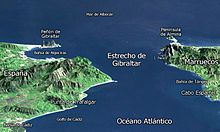
The strait is the only connection between the Mediterranean Sea and the Atlantic Ocean. It is located between the Alboran Sea and the Gulf of Cádiz. It covers from the Gibraltar-Ceuta line to the Cape Espartel-Cape Trafalgar line. Its length is 14.4 km at its narrowest part, between Punta de Oliveros (Spain) and Punta Cires (Morocco), and its depth varies from about 280 m at the threshold of Camarinal to just under 1000 m at the height of the bay of Algeciras.
Environmental conditions
In this place, the meteorological conditions are unique for tens of kilometers. The relief channels the wind, which can take two different directions: west and east; that is, wind from west or east. It accelerates brutally and reaches up to 40 and 50 knots near the Rock of Gibraltar. However, 20 km before or after can be weak or non-existent.
Through the Strait of Gibraltar, water is exchanged between the Atlantic Ocean and the Mediterranean Sea. On average, the surface waters (relatively warm and not very saline) from the Atlantic enter the Mediterranean; conversely, the deep waters (relatively cold and saline) come out of the Mediterranean.
Tidal currents are strong and vary throughout the day, causing diving accidents. In addition, its funnel shape and the coastal massifs on both sides of the strait often create very strong winds.
The city of Gibraltar is British territory, where you can see the only wild monkeys in Europe. Currently, there are various companies dedicated to the tourist sighting of cetaceans.
On the Spanish side, the strait is part of the Strait Natural Park. On the African coast is Ceuta, a Spanish autonomous city.
On the other hand, the Strait of Gibraltar is a crossing point for numerous migrations:
- Landbirds between Europe and Africa, and marines between the Atlantic and the Mediterranean.
- Atunes and other marine migratory species between the Atlantic and the Mediterranean.
The Strait has been identified as an Important Bird Area by BirdLife International due to the hundreds of thousands of seabirds that use it each year to migrate between the Mediterranean and the Atlantic, including significant numbers of Cory's Shearwater, Balearic Shearwater, Audouin's Gull, Lesser Gull, Auks, and Atlantic Puffin.
A resident orca pod of about 36 individuals lives around the Strait, one of the few remaining in Western European waters. The herd may be threatened with extinction in the coming decades due to the long-term effects of PCB contamination.
Maritime traffic and illegal immigration
Its narrow width and the intense maritime traffic of its waters (more than 82,000 ships per year), both between the Atlantic and the Mediterranean and between Europe and Africa, make it one of the busiest crossings on the planet. In a revelation of a Wikileaks cable, the United States government warns of the strategic importance of the pass, as one of the most important places for global geostrategy.
Despite the intense surveillance of the Spanish coasts (with SIVE at the helm), and the collaboration agreements between Spain and Morocco to avoid it, it is also a crossing point for many small boats in which mainly African immigrants They are trying to get from Africa to Europe. The harsh conditions in which these immigrants travel mean that many die (hypothermia, drowning) in the attempt. Every year some 5,000 African immigrants try to cross the strait.
Infrastructures
Traditionally the most important port in the area has been that of Gibraltar, although in the XX century it has been largely surpassed through the port of Algeciras, which has specialized in serving as a stopover point for large ships that cross the strait on regular routes. In the last decade, a new port has been built on the African coast, the port of Tangier Med, whose objective is to complement Algeciras as a port of call.
In the transversal maritime traffic of the most important lines, the main port on the European coast is once again the port of Algeciras, which has recently been complemented by the port of Tarifa. On the African side, the main receiving port has been the port of Tangier, although much of the traffic has been transferred to Tangier Med, and the port of Ceuta. Regular ferry routes currently link Algeciras with Tanger Med and Ceuta, and Tarifa with Tangier.
Due to the great depth of the strait, there are few infrastructures that cross it, especially energy: a gas pipeline and two high-voltage lines cross the strait through the threshold of Camarinal.
The presence of strong winds has favored the development of wind energy and has given rise to an endless forest of electric wind turbines and the practice of windsurfing. Tarifa, at the southern tip of Spain, has been the scene of several world championships.
Territorial waters
Except at its eastern end, the strait lies within the territorial waters of Spain and Morocco. The United Kingdom claims 3 nautical miles (5.6 km) around Gibraltar on the north side of the Strait, placing a portion of it within British territorial waters. As this is less than the maximum of 12 nautical miles (22.2 km), it means, according to the British claim, that part of the Strait is in international waters. Ownership of Gibraltar and its territorial waters is disputed by Spain. Similarly, Morocco disputes Spanish sovereignty over Ceuta on the southern coast. There are several islets, such as the disputed island of Perejil, which are claimed by both Morocco and Spain.
Under the United Nations Convention on the Law of the Sea, ships passing through the strait do so under the regime of transit passage, rather than the more limited innocent passage allowed in the most territorial waters. Therefore, a ship or aircraft has the freedom of navigation or overflight to cross the Strait of Gibraltar.
Contenido relacionado
Panamerican's highway
Angolan Geography
Fasnia


