Stone Fountain Lagoon
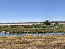
The Fuente de Piedra Lagoon is a wetland located in the Antequera region (Málaga), in the municipality of Fuente de Piedra, in Spain.
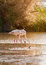
It is the largest lagoon in Andalusia, 6.5 km in length (northeast-southwest) and 2.5 km wide (northwest-southeast), and together with the Gallocanta lagoon it represents one of the two great lagoons that remain in the Iberian Peninsula. It constitutes the most important enclave where the greater flamingo (Phoenicopterus roseus) reproduces regularly, being the nesting colony of Fuente de Piedra, together with the one existing in the Camargue (France), the most important in the Mediterranean West and North West Africa.
The lagoon was declared a Ramsar site in 1983, a nature reserve on January 11, 1984, a Special Protection Zone for Birds (ZEPA) in 1988 and finally a Special Protection Zone for Birds (ZEPA) in 2013. and Special Conservation Zone (ZEC) since 2013. It covers 1364 ha of protected area, of which 164 ha make up the nature reserve.
It extends along a landscape of very gentle relief, covered with olive and cereal fields. It is endorheic and is supplied by rainfall, runoff and groundwater. It is also very seasonal, alternating long periods of flooding with others of drought.
Salt and gypsum are deposited in its basin, minerals that when dissolved in the lagoon water give it salinity. In spring, the lagoon dries up and salt crystallizes on its surface. This salt was commercially exploited from the Roman era until the 1950s. Inside the lagoon there are still vestiges of the channels that were used to evacuate the water and thus facilitate the sedimentation of the salt. Currently, these dikes are used for the nesting of many birds.
Physical and biotic characteristics
The lagoon is located in the watershed area between the Guadalquivir river basin (Atlantic slope) and the Guadalhorce river basin (Mediterranean slope). It constitutes the lowest level area of an endorheic or closed drainage basin of approximately 15,000 ha whose area is framed by the Laguna de la Ratosa basin and the Genil basin to the north, the Camorra and Mollina mountain ranges to the northeast, Sierra de Humilladero to the East, endorheic complex of the Campillos lagoons and Guadalhorce basin to the South, and detrital mantle associated with Sierra de los Caballos to the West. Located at an altitude of about 410 m s. no. m., the lagoon has a somewhat kidney-shaped elliptical shape with axes of length between 6.8 and 2.5 km and a perimeter of 18 km. With a very horizontal bottom and gentle slopes, the sheet of water does not usually exceed 2 m in depth, exceeding this figure only in exceptional conditions.
Geology
Both the lagoon and its surroundings are framed within the scope of the Betic mountain ranges, being located almost entirely in the space occupied by the Subbetic Zone within the so-called External Zones. In chronological order, the main geological formations that come together in this space are the Miocene materials and the Quaternary deposits. In general, the surroundings of the lagoon are characterized by gentle slopes (less than 4%) with altitudes that oscillate between 410 m in the lowest areas where the lagoon is located and a maximum of 434 m, with the exception of the mountains. surrounding. The orography of the place is strong in the Jurassic mountains, ridged with moderate to gentle slopes over the Miocene and smooth to flat in the Quaternary materials. The origin of the lagoon is associated, according to one of the most accepted hypotheses, to the karstic processes of dissolution and subsidence.
Climate
The Fuente de Piedra lagoon is influenced by the temperate Mediterranean continental climate, with a dry season (spring-summer) and another season with a predominance of torrential rains (autumn-winter). The average annual rainfall in the basin is around 460 mm/year. There is a great variation in the interannual distribution of rainfall with hydrological years where they exceed 700 mm/year and others in which they barely reach 200 mm/year. Throughout the year the most intense rains are concentrated between the months of November to February, with July being the driest month.
Hydrology
The Fuente de Piedra lagoon is nourished by contributions from rainwater directly on the lagoon, by the runoff from its basin contributed by the different streams that flow into it, and by underground discharge from the surrounding aquifers. The natural outlet is done by evaporation. Result of the combined action of climatic and hydrogeological factors, the Fuente de Piedra lagoon maintains, in average hydrological conditions, a sufficient sheet of water for the persistence of habitats and species of great ecological interest. Despite having a mixed feeding typology (surface and groundwater contributions), in dry weather cycles it is groundwater that constitutes the fundamental contribution (hypogenic behavior). Several streams feed the lagoon with their waters, although currently none of them do so permanently due to the multitude of catchments carried out. In the peripheral areas of the lagoon there are small sectors that, under exceptional recharge conditions, are flooded during periods whose duration depends on the intensity of rainfall.
Flora and fauna
It is an important place for nesting, wintering, and migratory passage for many waterfowl. It is home to the largest colony of flamingos (greater flamingo) in the Iberian Peninsula and the second largest in Europe, which can be observed during the nesting period (March-July) along with many other species, such as the Black-billed Shout, Black-headed Gull and the picofina, the kentish plover, the stilt or the avocet. In the winter period (November-February) cranes, ducks such as the shoveler and some waders are observed. In the periods of migratory passage waders and birds of prey appear.
A good part of the flamingos born in the Fuente de Piedra lagoon spend the winter in Morocco, particularly at the mouth of the Muluya river, in the coastal lagoon of Mar Chica or in the Souss-Massa National Park. During the chick-rearing period, the feeding areas used by the adults are the Cabo de Gata salt pans, the Odiel Marshes and, fundamentally, the Guadalquivir Marshes. The monitoring of ringed individuals has made it possible to establish that the flamingos that breed in Fuente de Piedra feed in wetlands located within a radius of 200 km around the colony.
The saline waters of the lagoon allow the development of halophytic vegetation such as reeds, rushes and reeds, together with the Mediterranean scrub.
Fonts
- This article is a work derived from the provision concerning the process of declaration or initiation of a cultural or natural good, a text that is free of known restrictions under the copyright in accordance with article 13 of the Spanish Intellectual Property Law.
Contenido relacionado
Benaocaz
Algeciras (disambiguation)
Annex: Municipalities of the province of Barcelona

