
St lawrence river
The Saint Lawrence River (French: fleuve Saint-Laurent; English: Saint Lawrence River; in Tuscarora, Kahnawáˀkye; in Mohawk, Kaniatarowanenneh, which means "great waterway") is one of the main rivers of North America, the collector of Great Lakes that connects with the Atlantic Ocean, in the Gulf of San Lorenzo. In its first section it forms the natural border between the United States and Canada, bordering the west of the province of Ontario, and then it enters Quebec completely through it. It belongs to the Lawrence lake system.
The St. Lawrence is a large river that runs through the mid-latitudes of the continent. It is born in Lake Ontario, next to Kingston, to later pass through the cities of Brockville and Cornwall (in the province of Ontario); and Montreal, Trois-Rivières and Quebec City (in Quebec). It empties into the Atlantic after crossing the San Lorenzo estuary, the largest estuary in the world, after a journey of more than 3000 km (3058 km, being the 2nd longest river in Canada and one of the 25 longest rivers in the world). Ignoring its sources in the Great Lakes, the St. Lawrence River, from its outlet in Lake Ontario, is 1197 km in length. Its farthest ridge is that of the North River,
- Saint Louis River at Lake Seven Beaver, at the Mesabi mountain range in Hibbing, Minnesota, the most distant source of Lake Superior.
The river is part of the St. Lawrence fluvial system, which would be formed by the following succession of rivers and lakes: North River – Saint Louis River – Superior Lake – St. Marys River – Lake Huron – Sainte-Claire River – Lake Sainte-Claire – Detroit River – Lake Erie – Niagara River – Lake Ontario – Saint Lawrence River – Saint Lawrence Estuary. The river is also part of the Great Lakes waterway.
Its watershed—a large portion of the North American continent, including the entire Great Lakes region, the world's largest freshwater lake system and accounting for nearly 25% of the world's total freshwater reserves— drains an area of 1,344,200 km², of which 839,200 km² is in Canada and 505,000 km² in the United States. The basin includes parts of the Canadian provinces of Ontario and Quebec and the states of Illinois, Indiana, Michigan, Minnesota, New York, Ohio, Pennsylvania, Vermont and Wisconsin. The average flow at the mouth is 9,850 m³/s.
Toponymy
Originally called in Mohawk Kakanoaakakagaalla, the river was explored by the Frenchman Jacques Cartier, who gave it the name "Great River of Hochelaga" (Grand fleuve de Hochelaga) and called a re-entrant from the Côte-Nord “baye saint Laurens”. Later, the term San Lorenzo (Saint-Laurent) was also applied to the gulf that follows the river, which will be better known in the XVI as the "Great River of Canada" (Grande rivière de Canada). In 1603, Samuel de Champlain first designated this river the "river of the Canadas" (riviere de Canadas) but, after 1604, the founder of Quebec chose in his writings and letters to refer to to him as the "great river of Saint Lawrence" (grande riviere de saint Laurens). It was not until the 17th century century that the place name "Río San Lorenzo" finally managed to replace its competitors.
The river owes its name to Saint Lawrence, a Christian saint who is celebrated by the church on August 10, the day Jacques Cartier first sailed on the waters of the river.
Geography
The Saint Lawrence River originates at the mouth of Lake Ontario, in the vicinity of the Canadian city of Kingston (Ontario), located on the north shore of the lake, Wolfe Island, halfway, and Cape Vincent, NY. From there, it passes through Gananoque, Brockville, Ogdensburg, Massena, Cornwall, Montreal, Trois-Rivières and Quebec City until it empties into the Gulf of Saint Lawrence through the Saint Lawrence Estuary, the largest estuary in the world.
The river includes some important lakes, such as Lake Saint-Louis, south of Montreal; Lake Saint-Françoi, in Salaberry-de-Valleyfield, Quebec; and Lake Saint-Pierre, east of Montreal. In its waters there are three archipelagos: the Thousand Islands (Thousand Islands), a chain of islands near Kingston (Ontario); the Hochelaga archipelago, which includes the island of Montreal and Île Jésus (Laval) and the smallest, the Mingan archipelago. Other islands in the river are the Isle of Orleans, near Quebec City, and the Isle of Anticosti, north of the Gaspé Peninsula.
Lake Champlain and the Ottawa, Richelieu (which rises in Lake Champlain), and Saguenay rivers all drain through the St. Lawrence River.
Tides cease at Trois-Rivières (or its surroundings, or downstream, or at Lake Saint-Pierre) and water salinity begins east (downstream) of the Île d'Orléans: salt water as far as Tadoussac and brackish water to Cap Tourmente.
Hydrology and tributaries
The St. Lawrence River has an average flow of 7,543 m³/s at the height of Cornwall, Ontario. At the height of Quebec City, after receiving the contribution of several important tributaries, the Saint Lawrence has an average flow of 12,309 m³/s.
Between these two cities, the main tributaries of the river are the following:
- River Ottawa (2100 m3/s)
- Saint-Maurice river (663 m3/s);
- River Richelieu (355 m3/s);
- river Saint-François (190 m3/s);
- Chaudière river (109 m3/s);
In eastern Quebec, several major rivers, especially those of the Côte-Nord, flow into the St. Lawrence estuary. They stand out among them:
- Saguenay River (1460 m3/s);
- Manicouagan river (877 m3/s);
- Outardes river (391 m3/s);
- River Betsiamites (323 m3/s).
The flow of the St. Lawrence River upstream of the Ottawa River has a very regular profile. This natural regularity has been reinforced by the development of various retention structures along its course and in the Great Lakes region. The minimum flow measured during the period 1860-1972 at the Ogdenburg hydrological station was 4360 m³/s, while the maximum flow was 8891 m³/s. The Ottawa River has a much more irregular regime, with significant spring floods, and its influence is felt in the regime of the Saint Lawrence River downstream of its confluence.
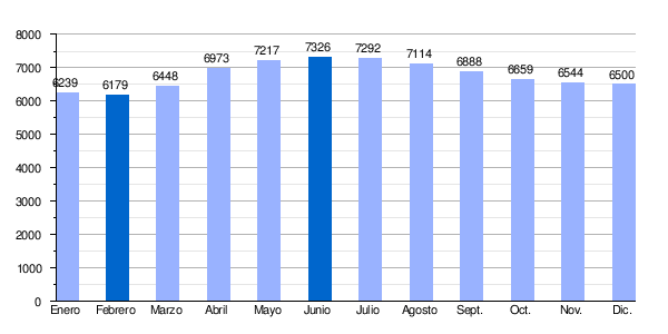
| San Lorenzo average monthly flow rate at Ogdensburg hydrological station, New York (in m3/s and calculated in the period 1860-1972) |
 |
History
Geological and hydrographic formation

The present site of the St. Lawrence River Valley has been occupied, for nearly a billion years, by a high plateau similar to the present-day Tibetan Plateau. Around 600 million years ago, the supercontinent Pannotia broke up into four sub-continents, Laurentia, Baltica, Siberia and Gondwana giving birth in the region to a vast ocean called Iapetus. At the same time, many cracks and trenches formed along the axis that gave rise to the formation of the future San Lorenzo.
During the last ice age, called Wisconsin, a huge ice cap, the Inlandsis laurentidien, covered a large part of the North American continent. The ice retreated due to global warming there about 12,000 years ago. years, giving way after that in the current valley of the Saint Lawrence River to a vast inland sea, the Sea of Champlain. After the elevation of the continent by a phenomenon of isostasy, the sea withdrew in turn, giving way to the current San Lorenzo River. The complete melting of the inlandsis laurentidien ice, around 6500 BC. C., created the current fluvial and lacustrine system, the hydrographic relief, of the San Lorenzo river
The St. Lawrence River lies in a seismically active zone, where reactivation of the fault is believed to have occurred throughout the late Proterozoic to early Paleozoic, with normal faulting related to the opening of the Iapetian Ocean. The faults in the area are connected rifts, which is called the Saint Lawrence rift system (Saint Lawrence rift system).
The St. Lawrence Valley is a physiographic province in the Greater Appalachian Division, which contains the Champlain Valley and the Northern physiographic section.
Valley settlement
Archaeological excavations allow us to assess the Amerindian presence bordering the river until about 9,000 years BC. The river, long before it was named Fleuve Saint-Laurent, was called Magtogoek, meaning "the road that marches" by the Amerindian peoples who lived in the region. On the other hand, it is probable (but without concrete evidence at the moment) that Viking navigators also traveled the region.
In 1534, Jacques Cartier, a Malou, officially took possession of these lands in the name of King Francis I of France. Cartier is generally regarded as the discoverer of the St. Lawrence Valley. As early as the 17th century, the French had the custom of name the stretch upstream of the city of Montreal and the Ottawa River as the Saint Lawrence River. The San Lorenzo has served as the main itinerary for the exploration of the interior of North America.
History of European occupation


The San Lorenzo estuary was visited by many sailors (such as John Cabot and Jacques Cartier) and by Basque fishermen shortly after the discovery of America (or perhaps even before). But the first known European explorer to navigate the inner part of the St. Lawrence was Jacques Cartier, during his second voyage to Canada in 1535, with the help of the two sons of the Iroquois chief Donnacona. Arriving at the estuary on the feast of St. Lawrence, Cartier named it the Gulf of St. Lawrence. The land along the river was inhabited at the time by the Iroquois peoples of the St. Lawrence. The St. Lawrence River is partly in the US and as such is the sixth oldest surviving European place name for that country.
Until the early 1600s, the French used the name Rivière du Canada to designate the St. Lawrence River upstream of Montreal and the Ottawa River after Montreal. The Saint Lawrence River served as the main avenue for European exploration of the North American interior, first by the pioneering French explorer Samuel de Champlain.
Control of the river was crucial to the British strategy to capture New France in the Seven Years' War. After having captured Louisbourg in 1758, the English sailed up the river to Quebec the following year, thanks to charts drawn up by James Cook. British troops were ferried across the St. Lawrence River to attack the city from the west, which they did successfully in the Battle of the Plains of Abraham.
Due to nearly impassable rapids called the Lachine Rapids, the St. Lawrence was continuously navigable only as far as Montreal. The Lachine Canal, opened in 1825, was the first to allow ships to pass the rapids. An extensive system of canals and locks, known as the Saint Lawrence Seaway (Saint Lawrence Seaway), was officially opened on June 26, 1959 by Queen Elizabeth II (on behalf of Canada), and President Dwight D. Eisenhower (representing the United States). The seaway now allows passage for ocean-going ships to Lake Superior.
During World War II, the Battle of the St. Lawrence involved a number of submarine and anti-submarine actions along the lower St. Lawrence and throughout the Gulf of St. Lawrence, Belle Isle Strait, and the Cabot Strait, from May to October 1942, in September 1943 and again in October and November 1944. During this time, German U-boats sank three Canadian warships as well as large numbers of merchantmen.
In the late 1970s, the river was the subject of a successful environmental campaign called "Save the River" or "Protect le fleuve" ("protect the river"), originally in response to development plans envisioned by the US Army Corps of Engineers. The campaign was organized, among others, by Abbie Hoffman, better known under the pseudonym Barry Freed.
Pollution
The St. Lawrence River runs through a densely populated region, particularly upriver from Quebec City. Agriculture, urbanization and industrialization put constant pressure on the river. In the past 20 years, considerable efforts have drastically reduced pollution in waterways so much so that bathing is now possible most of the time upstream of eastern Montreal, and downstream of Lake Saint-Pierre. The health of the river remains fragile and much remains to be done, especially in relation to the heavy metals being dumped into the river, which continue to affect the fragile health of the beluga population at the mouth of the Saguenay River.
Navigation


The San Lorenzo River is one of the main natural routes of penetration into the interior of the North American continent. For this reason, navigation in your course quickly became such an important topic. In its natural state, the river did not allow the navigation of ocean-going vessels more than as far as Quebec City. Even smaller boats could not, at an early stage, go beyond Montreal into the Great Lakes, due to the significant barrier of the well-known rapids area of the Lachine Rapids. Beginning in the 1700s, work began to improve transportation on the St. Lawrence River by creating a channel around the Lachine Rapids, but that work was never completed.
Commercial navigation on the river could not develop until the construction of the Lachine canal, in 1825, and the subsequent dredging of the section between Montreal and Quebec, starting in 1851. These works allowed Montreal to consolidate itself as an industrial metropolis from Canada, through its port. The Lachine Canal, 13.6 km long, had an original depth of only 1.5 m and had six locks. It was widened and deepened several times until it was replaced in 1959 by the Great Lakes Waterway, which connects Montreal to the Great Lakes via a deep-water channel with a minimum draft of 8.2 m. In the section between Quebec and Montreal, the navigation channel located in the middle of the Saint Lawrence River has been deepened and widened several times:
| Year | Minimal depth of the channel | Minimal widening of the channel |
|---|---|---|
| 1851 | 4.2 m | 45 m |
| 1854 | 4.9 m | 45 m |
| 1865 | 6.1 m | 90 m |
| 1882 | 7.6 m | 90 m |
| 1888 | 8.4 m | 90 m |
| 1907 | 9,1 m | 140 m |
| 1952 | 10.7 m | 150 m |
| 1970 | 10.7 m | 245 m |
| 1992 | 11 m | 230 m |
| 1999 | 11,3 m | 230 m |
In 2005, traffic on the inland waterways of the Great Lakes and St. Lawrence reached 255 million tons, broken down as follows:
- 105 Mt transshipped in the ports of Quebec;
- 11.2 Mt in transit through the San Lorenzo River (direct movements between the ports of the Great Lakes and the rest of the world, without transfers in the ports of Quebec);
- 9.5 Mt exchanged in the Great Lakes between ports of Ontario;
- 43.3 Mt exchanged in the Great Lakes between Ontario and the USA. U.S.;
- 87.3 Mt exchanged in the Great Lakes between the United States.
Sea traffic attributable to Quebec ports on the St. Lawrence River
In 2005, 105 million tons of cargo were transshipped at the Saint Lawrence ports located in the province of Quebec. This tonnage has changed little since 1995, although the patterns of trade (nature, origin and destination of the loads treated) have indeed evolved a lot during that period. Those 105 Mt were distributed as follows:
- 34.9 Mt exchanged with Europe;
- 10.9 Mt exchanged with Ontario
- 2.8 Mt exchanged with maritime provinces;
- 17,2 Mt exchanged with the US. (of which 8.6 Mt with the ports of the Great Lakes)
- 10.8 Mt exchanged with Africa;
- 9.7 Mt exchanged with Latin America;
- 8.7 Mt exchanged with Asia;
- 2.4 Mt exchanged with Oceania;
- 7,1 Mt exchanged between the ports of Quebec.
The main ports in Quebec on the Saint Lawrence River are as follows:
- Montreal, with 24 Mt;
- Quebec, with 22.6 Mt;
- Sept-Iles, 22.2 Mt;
- Port-Cartier, with 15.4 Mt;
- Sorel, with 5.2 Mt
The San Lorenzo pilots
Despite the navigation aids that have been implanted along its banks and modern technology (GPS, radar, etc.) the Saint Lawrence River remains one of the most dangerous channels in the world: the Tides can exceed six metres, currents are strong and multidirectional, shoals are numerous and visibility is often severely limited, especially in winter, when ice further increases the dangers. For this reason, between Les Escoumins and Montreal, commercial ships over 100 feet long that operate on the St. Lawrence must necessarily be guided by licensed pilots to ensure safety and protect river and marine ecosystems.
Each pilot of the Saint Lawrence is qualified to navigate one of the three piloting sections of the river: Les Escoumins – Quebec City, Quebec – Trois-Rivières and between Trois-Rivières and Montréal.
History of river piloting
Early explorers quickly discovered the major pitfalls that made natural navigation on the St. Lawrence River so difficult along its course. It was often by risking their lives that early navigators ventured into the Gulf, then the estuary, and finally the river.
In the days of New France, although quite detailed charts were drawn that could help captains, the French refused to apply navigation aids such as lighthouses or buoys, since they could have served the English during a hypothetical river invasion. They had to find a solution to protect the ships and the crews that entered the San Lorenzo and for this reason, the New France government resorted to experienced pilots, who knew all the traps of the river, to guide the navigation. The king's first pilot was named around 1640, Abraham Martin, the man who named the Plains of Abraham in Quebec after him. In 1671, the Quebec Jesuit College offered the first course to train pilots specialized in maritime navigation on the St. Lawrence River. After the English conquest, the colonial government maintained the obligation to entrust the care of the ships to maritime pilots.
In 1805, the Parliament of Lower Canada established a public corporation, the House of the Trinity (Maison de la Trinité) of Quebec, with the responsibility of improving the efficiency and safety of the navigation through the installation of buoys, beacons and lighthouses. The first lighthouse on the Saint Lawrence River was built in 1809 on Isla Verde, along Tadoussac. It was followed by several more, and by 1867, 23 lighthouses guided ships from the river estuary to Quebec. Many of them still exist. The House of the Trinity also had authority for the regulation of piloting, pilots and the training of their apprentices.
Since 1860, membership of a recognized corporation was mandatory for all pilots. The Central Saint Lawrence Pilots Corporation (Corporation des pilotes du Bas Saint-Laurent central ) and the Lower Saint Lawrence Pilots Corporation (Corporation des Pilotes du Bas Saint-Laurent ) regroup the 200 pilots who sail between Quebec and Montreal, the former, and between Les Escoumins and Quebec, the latter.
Wildlife
The St. Lawrence River is home to many cetaceans, including the blue whale, fin whale, and beluga whale, which are left to feed in the mouth of the rich Saguenay.
Carp imported from Europe multiplied, which in the San Lorenzo are one of the largest current populations in the world with heavy specimens of up to 25 kg. In September 2011, the world championships of carp fishing.
Among the native fish fauna there are species such as the sea lamprey, northern pike (Lepisosteus osseus), Amia calva, mooneye fish, alosa-herring, lake herring ( Coregonus artedii), whitefish (Coregonus clupeaformis), rainbow trout, brown trout (Salmo trutta fario), lake trout (Salvelinus namaycush), brook trout (Salvelinus fontinalis), smelts (Osmeridae), mudminnow (Umbra limi), pike, muskellunge musky (Esox masquinongy), brown horse (Moxostoma hubbsi), white sucker (Catostomus commersoni), with the corresponding golden minnow or keeled sardine (Notemigonus crysoleucas), brook carp (Semotilus atromaculatus), red northern carp (Phoxinus eos), Blackchin Shiner (Notropis Heterodon), American catfish (Ictalurus punctatus) or dwarf catfish (Ictalurus nebulosus), American eel (Anguilla rostrata), Burbot, striped killifish (Fundulus diaphanus), sticklebacks, perch trout, white perch (Morone americana), smallmouth bass (Micropterus dolomieui), perch American bass (Micropterus salmoides), bluegill (Lepomis gibbosus), rock perch (Ambloplites rupestris), black pomoxis (Pomoxis nigromaculatus ), American sander (Stizostedion vitreo), freshwater croaker (Aplodinotus grunniens), etc.
The river in culture
The St. Lawrence River is at the heart of many novels dealing with or set in Quebec (as in Anne Hébert's novel Kamouraska, or L'avalée des avalés, by Réjean Ducharme), in poems (in the works of Pierre Morency and Bernard Pozier) or songs (as in Suzanne, by Leonard Cohen or L'oubli, by Richard Michel). The river has also been portrayed in many pictorial works, in particular by the artists that are members of the group of seven. In addition, the river is the namesake of the Saint-Laurent Herald at the Canadian Heraldic Authority.
In 1980, Jacques Cousteau traveled to Canada to make two films about the St. Lawrence River and the Great Lakes, Cries from the Deep `and SSt. Lawrence: Stairway to the Sea.

Contenido relacionado
Nigeria
Lambert conformal projection
Morocco