
Southern cone
The Southern Cone is the southernmost area of the American continent that, like a large peninsula, defines the south of the South American subcontinent.
Geographically, the Southern Cone of America is the southern portion of the American continent whose shape resembles that of a scalene triangle. This would have Cape Horn as its vertex while its rays would run along the coasts of the Atlantic and Pacific oceans to the inflection points of the coastlines in which the end of the peninsular area that South America has would be verified.: Arica, in the Pacific, and approximately the border between the state of Paraná and São Paulo, in the Atlantic. Its northern limit would be the line that unites them and crosses Paraguay longitudinally.
In its most limited concept, it geopolitically includes Argentina, Chile, Paraguay and Uruguay, occupying a total area of 4120317 km², a territory bordered on the north by the states of Bolivia, Brazil, Paraguay and Peru, on the east by the ocean Atlantic, to the south with the Drake Passage or Mar de Hoces —this is the closest continental zone to Antarctica, with a distance of 960 km between the two— and to the west with the Pacific Ocean.
The integration of Paraguay is essential to address the issue coherently, because geographically it is part of the set of closely related geographical areas in the region, mainly sharing elements of a cultural, historical and political nature that compose it, since at the same time Considering ethnic, economic and social characteristics critically, these do not represent a considerable difference with respect to the other countries of the Southern Cone.
Occasionally, and in its broader concept, in terms of similarities between the countries in the area, it would include Argentina, Chile, Uruguay, Paraguay, and Brazil (only the southern part that is made up of São Paulo and the Southern Region —which is made up of Paraná, Río Grande do Sul and Santa Catarina—). The total area of the area thus delimited would reach 4,697,035 km².
This article deals with the Southern Cone in its most limited concept; that is, the territory that includes Argentina, Chile, Paraguay and Uruguay.
Geography
The Southern Cone is one of the few portions of land that falls within the southern hemisphere and also the oceanic hemisphere as it contains most of the Earth's oceans. It is also the southern portion of the western hemisphere.
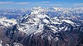
Monte Aconcagua, in Argentina, is the highest point on the planet outside the Himalayas, the highest altitude summit in the southern and western hemispheres.

The Atacama Desert in Chile is the most arid desert on the planet.

Wet pampa, ecoregion shared by Argentina, Uruguay and southern Brazil.
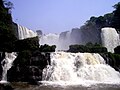
Cataracts and jumps, large volume of water falling abruptly from the high cause of the flowing rivers in the region. In the image, Saltos del Monday in Paraguay.

Cadeciduous forests and native conifers in the Patagonia of Chile and Argentina. In the image, Parque Nacional Villarrica, in Chile.

Southern Patagonian icefield, located in Chile and to a lesser extent Argentina.


Geomorphology
Notable geographic features include:
- The Andes mountain range, which in the Southern Cone acquires the highest altitudes of the Western Hemisphere and the Southern Hemisphere (more specifically: the highest elevations of the planet outside Asia); by contrast, also in the Southern Cone there are the largest continental depressions of the Southern Hemisphere and of the whole of America under the sea level (Great of San Julian).
- The dilated and fertile plains of the Pampa and the Chaco, contrasted by the so-called arid diagonal that extends from the Atacama Desert, the most arid in the world, to certain semi-desert regions of the East Patagonia coast.
- The Patagonian plateau, especially the Yugoslav archipelago and its continuation on the marine platform, the Falkland Islands.
- The great estuaries and rivers: to the widest river / estuary of the planet Earth (the Rio de la Plata), the great rivers of the basin of the Silver as is the Paraná, Paraguay, Uruguay, Iguazú (with the cataracts homonym), Pilcomayo, Bermejo, Salado del Norte that form a system of feedback with the gigantic Guaraní aquifer that populates in Gran
- The Argentinian Sea, one of the most extensive epicontinental platforms, and therefore submarines, of the planet Earth.
- The Patagonian ice fields accompanied by large active glaciers.
- Large and important lacust systems of glacial origin (produced after the regression of the last Wurmiense glaciation about 11 000 years ago) such as those found in southern Chile and in the Andean region of Argentina and Chile, or large salt lakes of tectonic origin as in Mar Chiquita in the center of American continental Argentina.
- The southern part of the massif commonly called Brasilia.

The geology of the Southern Cone is complex: all the emerged territory corresponds to the South American plate, which is quite stable in most of the territory, which means that most of the Southern Cone is exempt from major earthquakes. However, the western and southern edges of this plate are in permanent friction and collision with the Nazca plate that drifts to the east. The western end of the Southern Cone forms part of the Pacific fire ring that south of Cape Horn It continues through the Antarillas and the Antartandes. The collision of both plates has caused the main recent orographic folding (the Andes continue to rise very slowly), and this friction on the western coast of the Southern Cone continues to release enormous amounts of energy by producing subduction earthquakes in the form of mega-earthquakes that mainly affect the central and central-southern Chile and the center of the Argentine region of Cuyo. It should be noted that the largest earthquake recorded by seismographs occurred in the Chilean city of Valdivia in 1960 and was followed in magnitude by the earthquake of February 27, 2010, in the city of Concepción, also in south-central Chile.
From west to east, after the Andean folding with its many volcanoes (the vast majority of them inactive), there are tectonic trenches and horsts, while the glacial lakes are dammed by hills of moraine origin (drumlins) that partially form the orographic system of the Patagonides, the drumlins of Patagonia or divert the water flows produced by the copious rainfall in the Andes mountain range towards the Pacific Ocean creating rivers of very little traveled but very mighty (Baker, Futaleufú, Puelo, Lena, Palena etc.) or indicate the waters that are tributaries of the Atlantic Ocean creating extensive and beautiful lakes of glacial origin (such as Lácar, Aluminé, Nahuel Huapi, Buenos Aires, Argentino, Viedma, Fontana, Fagnano-Kami, etc.). The retreat of the great Wurmian glaciers has left isolated mountains between stepped plateaus, basaltic and granitic mountains called chihuidos, very close to extensive canyons and estuaries in Eastern Patagonia and fjords in Western Patagonia and the southern tip of Tierra del Fuego (up to and including the Island of the States). On the other hand, the maritime straits such as Magellan and the Beagle are old valleys caused by the great glaciers, which at the end of the Wurmian glaciation and when the enormous glaciers withdrew, were invaded by marine waters.
To the north of the Argentinian Río Negro, a river that largely runs along the geological fault line that separates the Brasilia massif from the Patagonia massif, the lands are much flatter, the very flat and very fertile extensive plain extending to the Atlantic Ocean Chacopampean to a large extent covered by a type of podzol soil and above all of a loessic type that is rarely interrupted in its current relief by low-altitude mountain systems, highly eroded remains of ancient mountain ranges.
In the northeast of the Southern Cone, the Paraná traps (steps) stand out, which in addition to constituting a large part of the plateaus or "planalto" of the northeast of the Southern Cone, form part of the geological limits in the Atlantic Ocean.
Climate


The Southern Cone benefits from a wide variety of climates, which implies an extraordinary variety of biomes and landscapes.
From north to south, the climate changes from tropical to snowy cold, with a mountain climate in the Andes.
The northern part of the region, except for the altiplano or Puna and northern Chile, has a tropical climate. The climate is desert in the northwest of the Southern Cone —as in the Atacama desert, the driest on Earth.
In central Argentina and Uruguay the climate is temperate, while in central Chile it is Mediterranean, with a long dry season in summer.
In the south, the climate is cold oceanic rainy/snowy; however, eastern Patagonia has a cold arid climate. The southern end of the region has a climate of the isothermal tundra type, cold with even temperatures throughout the year.
The Andes mountain range has little rainfall, almost zero for years, north of the Tropic of Capricorn, which gradually and enormously increases south of parallel 39°S, from where it exceeds 2000 mm/year, either in form of rain, sleet or snow.
The seasons marked in the center of Argentina, the center of Chile and in Uruguay resemble the European climate or certain areas of the United States. In addition, the Mediterranean climate is present in the Sierras de Córdoba, Cuyo and central Chile, which makes these areas similar to California or Spain.
The coldest regions of the Southern Cone are southern Chile and southern Argentina, where winter is longer and more noticeable. Ushuaia and Puerto Williams are almost at the same antipodal latitude as Copenhagen, but the climate is even colder than in the northern European areas for two reasons: the proximity of Antarctica and the absence of a warm current like the one in the Gulf that warms the the European countries in latitudes equivalent to those of Conosur (on the other hand, given the greater presence of continental masses in the northern hemisphere, the thermal equator is located closer to Europe and North America than to the Southern Cone) all this explains, plus the Andean elevations, that in the southernmost part of the Southern Cone there are extensive areas of ice fields all year round.
Hydrography

The main river basin is the Cuenca del Plata, which includes large rivers such as the Paraná, the Paraguay, the Uruguay, the Pilcomayo, the Bermejo, the Iguazú, the Uruguayan Negro river, the northern Salado, the Buenos Aires Salado and the Third River.
Other basins also stand out, such as the Argentine Colorado River basin, which is occasionally fed by the Argentine Desaguadero basin, the Argentine Negro basin and the Santa Cruz basin.
On the slope of the Pacific Ocean, the Loa, Choapa, Río Rapel, Aconcagua, Maipo, Maule, Biobío, Palena and Baker rivers stand out.
In common with a large part of the La Plata Basin, the sources of the Patagonian rivers and the slope of the Pacific Ocean are found in the Andes mountain range, the backbone orographic system of the Southern Cone.
Population

Demographics
The Southern Cone has a population of approximately 60 million inhabitants, of which 67% live in Argentina, 28% in Chile and 5% in Uruguay.
Likewise, the countries of the Southern Cone average lower birth rates and higher life expectancy (Chile: 81.7 years, the highest in Latin America; Uruguay: 77.2 years and Argentina: 76.3 years in 2015) than the rest of South America.
Ethnic composition
The origin of the region's population varies according to the sector of the states that are part of the Southern Cone, being characterized, in general terms, by a mix with a greater European than indigenous contribution.
| Country | Lizcano 2005 | CIA 2021 | Genetic | |||||||||||||||
|---|---|---|---|---|---|---|---|---|---|---|---|---|---|---|---|---|---|---|
| AporteEuropeo | American sport | AporteAfrican | ||||||||||||||||
| 85.0 | 11,1 | 1.0 | 0.0 | 0.0 | 2.9 | 97.2 | 2.4 | 0.4 | ND | ND | 66.8 | 24.8 | 5.7 | |||||
| 52.7 | 39.3 | 8,0 | 0.0 | 0.0 | 0.0 | 88.9 | 9.9 | ND | ND | ND | 59.8 | 38.2 | 4.4 | |||||
| 88.0 | 8,0 | 0.0 | 4.0 | 0.0 | 0.0 | 87.7 | ND | 2.4 | ND | 4.6 | ND | 80.6 | 9,1 | 9,1 | ||||
| 20,0 | 74,5 | 1.5 | 3.5 | 0.0 | 0.5 | ND | 95.5 | ND | ND | ND | ND | 51.4 | 43,0 | 6.5 | ||||
Since the middle of the XIX century, the region has been the destination of large numbers of immigrants, mainly from Europe (Germany, Spain and Italy, among others) and the Middle East (Syria and Palestine). There are also other communities of Ashkenazi Jews, Gypsies, Mennonites and Sikhs. These immigrations apply exclusively to Chile, Uruguay and Argentina, countries that in historical geopolitics have been considered as new settlement lands along with Canada, Brazil, Australia, the United States and New Zealand.
In addition, the region is characterized by the presence of minorities belonging to pre-Hispanic peoples, mainly Aymaras, Calchaquíes, Guaraníes, Qoms (Tobas), Mapuches and Wichís, among others. Of these, more than two thirds live in Argentina, mostly belonging to the Mapuche people, while in Uruguay there is no indigenous population. Likewise, there is the presence of communities descendants of former African slaves in Uruguay, while in Argentina and Chile there are few Afro-descendants.
The current population of the Southern Cone is the direct result of a large wave of immigrants (mainly peasant and working class workers) who entered between 1850-1950, mostly Spanish and Italian. To these is added the contribution of the populations prior to independence, dating from the viceregal period, such as the original indigenous populations, Creoles, Afro-Americans and the huasos and gauchos. About 90% of the population of the Southern Cone calls itself "Euro-descendant", although genetically the American component certainly shows some variable degree of admixture.
Main urban centers
The countries of the Southern Cone have high rates of urban population. In Argentina, the 2001 census established that urbanization had reached 89.3% of the total population. In Chile, the urban concentration of its population is a demographic characteristic of the country; according to the 2002 census, the 86.59% of the national total lived in urban areas. In Uruguay, the 2004 census showed that the degree of urbanization reached 96.1% of the total population.
Ordered by amount of population, the following are the urban centers with more than 800,000 inhabitants in the Southern Cone in its most restricted sense:
| Post | Urban area | Country | Population by UN | Population by official source | Source |  |
|---|---|---|---|---|---|---|
| 1.o | Buenos Aires | 13 074 000 | 12 801 364 | Est INDEC 2010 | ||
| 2. | Santiago | Chile | 6 269 384 | 6 269 384 | [2] | |
| 3.o | Montevideo | Uruguay | 1 635 000 | - | ||
| 4.o | Córdoba | 1 493 000 | 1 399 000 | Est INDEC 2010 | ||
| 5.o | Rosario | 1 231 000 | 1 258 000 | Est INDEC 2010 | ||
| 6.o | Concepción | Chile | 1 009 285 | 1 009 285 | [3] | |
| 7. | Valparaiso | Chile | 918 000 | 851 173 | ||
| 8. | Mendoza | 917 000 | 1 086 066 | Est INDEC 2010 | ||
| 9. | Tucumán | 914 657 | 805 000 | Est INDEC 2010 | ||
| 10. | The Silver | 831 000 | 747 000 | Est INDEC 2010 |
Quality of life


One of the most significant characteristics of the Southern Cone is the higher average standards and quality of life that it exhibits in relation to other areas of Latin America.
Chile, Argentina and Uruguay have the three highest human development indices in Latin America. As a result of the 2017 United Nations Human Development Index report, both Chile, Argentina and Uruguay are considered the only three countries with HDI very high not only in the Southern Cone, but in all of Latin America —only surpassed in America by the United States and Canada. In addition, Chile and Uruguay are considered by the World Bank as high-income economies.
| 2015 | 2016 | 2017 | Trend | References | |
|---|---|---|---|---|---|
| Argentina | 0.822 | 0.822 | 0.825 | Argentina - HDI | |
| Chile | 0.840 | 0.842 | 0.843 | Chile - HDI | |
| Uruguay | 0.800 | 0.802 | 0.804 | Uruguay - HDI | |
| Paraguay | 0.723 | 0.721 | 0.724 | Paraguay - HDI | |
| Source: Global Human Development Indicators - United Nations Development Programme | |||||
In terms of education, illiteracy levels in the Southern Cone are the lowest in South America and are among the four lowest in Latin America, with a significant percentage of the adult population —men and women aged 15 or over— literate (Chile: 98.6%, Uruguay: 98.4% and Argentina: 97.9%, according to the 2015 UNDP report).
Uruguay, with US$431, is the country with the purchasing power of the highest minimum wage in all of Latin America after Panama. Chile (with US$428) also ranks among the top spots.
The distribution of income according to the UN, Uruguay stood at 0.379 points as of 2012 according to the Gini coefficient, which is used to measure the distribution of wealth in a nation, making it the most egalitarian country in Latin America. It places Argentina with 0.411, and Chile, with 0.497 in 2013.
Economy


| Economy 2019 (est.) | ||||
|---|---|---|---|---|
| Country | GDP (PPA) | PBI (PPA) per capita | GDP (nominal) | GDP per capita |
| USD 903 542 million. | USD 20 055 | USD 445 469 million. | USD 9 888 | |
| Chile | USD 502 846 million. | USD 26 317 | USD 294 237 million. | USD 15 399 |
| Uruguay | USD 82 969 million. | USD 23 581 | USD 59 918 million. | USD 17 029 |
In 2019, Argentina is the largest economy in the Southern Cone and second in all of South America, with a nominal GDP of 445,469 million dollars, it is the only country in the Southern Cone to be part of the G20, and a PPP GDP of 903,542 million dollars. Adding to Brazil in South America and Mexico in North America. Chile is the second economy in the Southern Cone and fifth in South America, with a nominal GDP of 294,237 million dollars and a GDP PPA of 502,846 million dollars. Uruguay is the third economy in the Southern Cone and the eighth in South America. South, with a nominal GDP of 59,918 million dollars and a PPA GDP of 82,969 million dollars.
On the other hand, the nominal GDP per capita of Uruguay is 17,029 dollars, that of Argentina is 9,888 dollars, and that of Chile is 15,399 dollars. Chile's GDP PPP per capita is 26,317 dollars, that of Argentina of 20,055 dollars and that of Uruguay of 23,581.
Argentina is the largest, most populous, industrialized and richest country according to GDP in the Southern Cone. It is one of the largest meat exporters in the world, and its production has been recognized numerous times for its high quality. It is the world's leading producer of sunflower, yerba mate, lemons, and soybean oil, second in honey and apples, the largest producer of wheat in Latin America. Argentina is the largest producer of wine in Latin America, fifth in the world, and the third global producer of lithium and the main producer of biodiesel (including bioethanol) globally. The Vaca Muerta oil field is one of the three main oil fields on planet Earth. The El Aguilar mining deposit, in the province of Jujuy, is the largest concentration of lead and zinc minerals in South America and Bajo de la Alumbrera in the province of Catamarca, is one of the largest open-pit mining operations in the world, for the extraction of gold and copper, Argentina being the thirteenth largest gold producer in the world. Argentina is the most important software producer in Latin America, and ranks second in South America in terms of auto parts manufacturing, after Brazil.[citation needed] It is the largest soybean producer on the planet along with Brazil and the United States. Along with Brazil and Mexico, it is a member of the G-20, which brings together the most industrialized, influential nations and most economically powerful in the world. It is also a founding member of Mercosur, the largest global food producer.
Chile is a member of the OECD, a group that only includes Canada, the United States and Mexico in the American continent. It also belongs to the Trans-Pacific Strategic Economic Partnership Agreement and APEC.
Chile is the country with the highest income by purchasing power parity per capita in Latin America, USD 22,470 in 2013, somewhat higher than Argentina, which reached USD 22,404 in the same period.
It shows remarkable indicators in terms of competitiveness, economic freedom, and economic growth. In addition, it has the most favorable external debt rating on the continent. Regarding foreign investment, in 2012 Chile accounted for almost 75% of the investments in the Southern Cone with USD 30,323 million, while in the same year foreign investment by national companies reached almost all of it (98%) with USD 21,090 million, followed by Argentina with USD 1 090 million. Despite its size, Chile exports a similar value to Argentina (USD 83 billion and 85 billion respectively). It is the world's largest producer of copper and has 38% of the world's reserves of that mineral. The state company Codelco operates, among others, the Chuquicamata and El Teniente deposits, the open pit mine and the underground copper mine largest in the world, respectively. In addition, Chile has 22% of the metallic lithium resources worldwide, surpassed by Bolivia, which has 24%.
In addition to exploiting its own domestic resources, Chile participates in numerous foreign mining projects, either as an investor or as an engineering and service provider, in countries such as Australia, Pakistan and Peru, among others. In addition to the mining industry, Chile It is also the world's largest producer of fresh grapes, accounting for 21.7% of global shipments, as well as fresh blueberries, prunes, dried apples
salmon, trout and lithium carbonate.
Uruguay is part of Mercosur, it concentrates a large amount of tourism in the coastal cities of Punta del Este and Maldonado. It is an agro-exporting country, for which agriculture: rice, wheat, corn, sunflower, sorghum, barley, soybeans, sugar cane (Bella Unión) and livestock (cattle, sheep) are the fundamental resources of the economy. The main industries are refrigerators, dairy. Likewise, Uruguay is the largest exporter of software per capita in Latin America and the unemployment rate in the aforementioned industry is 0%.
The climatic conditions of the Southern Cone, together with its physical geography, create the conditions for obtaining large productions of oats, barley, rye, wheat, olives, vines, rabbits, sheep, pigs, cattle, dairy products, and wines (emblematic strains: Cabernet, Carménère, Malbec, Merlot, Tannat and Torrontés) plus the production of rice, citrus, sunflower, corn, apples, potatoes and soybeans.
The subsoil of the Southern Cone is also valuable for its mining, highlighting the borax, copper, tin, lithium, gold, silver, lead and saltpeter mines in the Chilean Great North and in the Argentine Northwest as well as in the vicinity of the entire Andean and pre-Andean region where there are also large uranium deposits; there are important natural gas reserves in Magallanes, the north of Salta, and in the province of Neuquén. In this last province, there is the third largest gas reserve on the planet. Oil has reserves in several regions of Argentina, being medium in the Northwest and Cuyo, and of great importance in Patagonia. The next regional country in oil reserves is Chile, but its Magellanic basins only produced 10,640 barrels of oil, equivalent to 3.51% of the 302,700 consumed daily in 2010. The seas surrounding the Southern Cone are extremely rich in fishing and related resources, as well as its coasts present relevant tourist attractions worldwide.
This enormous wealth in the primary sector of the economy has facilitated for much of the XX century that most of the population will integrate the socioeconomic strata called media. However, during the last quarter of the XX century, most of the Southern Cone states suffered severely from a crisis global economy, accentuated in this region by a scant development of the secondary or industrial sector or, in the case of Argentina, directly by a process of de-industrialization, which has been reversed in recent years by increasing per capita income.


.jpeg)
Bioceanic corridors
The bi-oceanic corridors, also called «CB», are international routes that link certain regions and urban centers with different port terminals located both in the Pacific Ocean and in the Atlantic. Their objective is serve as a "physical-territorial" instrument to expedite trade in the countries of the Southern Cone (Mercosur and Chile); however, there are sources that rather speak of "transversal freight corridors" in the Southern Cone that have subregional integration as their objective.
The concept of bioceanic corridor arose in 1992 in Brazil, with the aim of creating and developing the "Capricorn Bioceanic Corridor" project between the Brazilian port of Santos and the Chilean port of Antofagasta, crossing southern Brazil, Paraguay, the provinces of Norte Grande Argentino and the Antofagasta Region in Chile.
Another project is the Agua Negra Pass. The construction of an interoceanic communication route has been projected, a tunnel in the Andes mountain range, which would connect the port of the city of Porto Alegre in the Atlantic Ocean with the port of the city of Coquimbo in the Pacific Ocean through from the center of Argentina.
The importance of these routes lies in the fact that the Southern Cone needs to place its exportable production on the world market, with the Asia-Pacific markets as its main objective. This would cause an increase in trade, encouraging exportable production in the areas of influence of the corridors.
Politics
During the second half of the 20th century, these countries were often ruled by military governments. In the 1970s, these regimes collaborated in the Condor Plan (led by the United States government) in the repression of the leftist opposition, vetoing political parties, dismantling guerrilla groups, imprisoning and torturing hundreds of thousands of people in clandestine centers of detention. As a result, tens of thousands of people were killed, many of whom are still missing (30,000 in Argentina, 1,200 in Chile, and 140 in Uruguay), and hundreds of thousands were exiled.
However, between the 1980s and 1990s, these countries regained democracy: Argentina in 1983, Uruguay in 1985, and Chile in 1990. Currently, Argentina and Chile are governed by left-leaning presidents, President Alberto Fernández and President Gabriel Boric, respectively. In Uruguay, Luis Alberto Lacalle Pou, belonging to the political center right. There is an alternation of power in the three countries, since the three presidents succeeded governments of different signs.
Separatist and autonomist movements
During the 1990s, separatist movements arose in the region. In Laguna on July 18, 1992, the secessionist movement O Sul é o Meu País ('The South is my country') was created, which seeks, through democratic and plebiscite, the separation of the South from Brazil with the aim of forming a new country. This movement has as references both the Juliana Republic and the Rio Grandense Republic. There are also other movements, Movimento pela Independência do Pampa ('Movement for the Independence of the Pampa', formed in 1990) and Movimento República de São Paulo ('Movimiento República de São Paulo') which are also seeking the separation of Brazil. On the other hand, in Chile and Argentina, various Mapuche indigenous groups seek autonomous instances or the independence of the territory that they call Wallmapu, that is, the lands controlled by the Mapuche until late from the XIX century, which would also cover part of Argentina.
Curiosities

- Only the football clubs of the countries that make up the Southern Cone (Argentina, Brazil, Chile, Paraguay and Uruguay) could participate in the Mercosur Cup, which was held from 1998 to 2001. However, the clubs of these countries could not participate in the Merconorte Cup, which was also held from 1998 to 2001 and in which only teams from Bolivia, Colombia, Ecuador, Peru and Venezuela participated; and which were subsequently joined by clubs from Costa Rica, the United States and Mexico. Both cups were played in parallel, and were organized by CONMEBOL.
- On July 29, 2017, the Argentine Football Association and the Uruguayan Football Association announced a joint nomination. Before Uruguay and Argentina tied without goals in Montevideo by the Clasificatorias to the world of Russia 2018, the Barcelona players Luis Suárez and Lionel Messi promoted the candidacy with commemorative t-shirts. On August 31, 2017, Paraguay suggested joining as third host. The Conmebol confirmed the triple candidacy in September 2017. The candidature of Uruguay-Argentina-Paraguay would coincide with the centenary of the first final of the World Cup of Football, which took place in Uruguay, and with the bicentennial of the first Constitution of Uruguay. On February 14, 2019, then president of Chile, Sebastián Piñera, announced that his country will also be part of the 2030 World Cup candidacy. On 7 February 2023 countries confirmed their joint candidacy to host the championship.
Contenido relacionado
Annex: Municipalities of the province of Las Palmas
1471
Villagelanguage