
Soria Province
Soria is a province in northern Spain, located at the eastern end of the autonomous community of Castilla y León.
Soria is by far the least populated Spanish province, with a density of 8.60 inhabitants/km²: one of the lowest in the European Union. The population of the province is 88,747 inhabitants (INE 2021). 44.44% (39,398) in 2018 lived in the capital, Soria. It also has one of the oldest populations in Europe: 6% of its inhabitants are over 85 years of age.
The province has more than 500 population centers, grouped into 183 municipalities, of which more than half (116) are towns with less than 100 inhabitants. Only eleven of them have more than 1,000 inhabitants and only Almazán, El Burgo de Osma and Soria capital have more than 5,000 inhabitants.
The average altitude, 1025 meters, and the mountains located to the north of the province condition the climate. To the east and south there are regions belonging to the Ebro basin, on the tributary of the Jalón river; in the north there are also areas that drain into the Ebro, the basins of the Alhama and Cidacos rivers. Most of the province forms the head of the Duero basin.
Several regions can be distinguished: Tierra de Ágreda, with its capital in Ágreda, bordering Aragón to the east and presided over by Moncayo; the Soriana Plateau; land of cereals and beets in the Duero Valley; on the border with the province of Burgos, Pinares, where the Picos de Urbión are located, the birthplace of the Duero and the mythical Laguna Negra that served as inspiration to Antonio Machado for his poem The land of Alvar González; Tierras Altas, to the northeast, a poor and rugged area but with important resources of footprints; and the southern regions of Soria, grain-producing and rich in sheep, which border the provinces of Segovia and Guadalajara.
On July 23, 2008, it became the first province to inaugurate the digital ignition integrated into the Specific Action Plan for Soria (PAES). Really, only the national analogue emissions of the emitters of the capital were disconnected and a third part of the province.
Toponymy
As is common in most of Spain, the province takes its name from its capital, the city of Soria. It has an uncertain etymology, possibly related to that of the Duero River. In February 1922, Pelayo Artigas made a proposal to change the name of the province to Numancia, reserving Soria only for the capital, an initiative that was supported by all Sorian institutions and personalities, as well as by the local press.. All of them advocated an identification of Soria with Numancia since there was a relationship between the forgetfulness of the heroic city and the marginalization and oblivion of the province of Soria. The division of opinions caused part of the Sorian public opinion to vary their thinking about of the need to identify Soria with Numancia, understanding that it was not necessary to get the province of Soria out of its situation of oblivion, abandonment and depression.
Geography

Its surface area is 10,306.42 km² and it is located at the eastern end of the autonomous community of Castilla y León. It limits with the autonomous community of La Rioja and with the provinces of Zaragoza (Aragón), Guadalajara (Castilla-La Mancha), Segovia and Burgos (Castilla y León).
| Northwest: Burgos | North: La Rioja | Northeast: La Rioja |
| West: Burgos |  | This: Zaragoza |
| Southwest: Segovia | South: Guadalajara | Sureste: Guadalajara |

Subsoil Resources
In the towns of Villarijo and Yanguas, in the north of the province of Soria, there were two modest spas. In Santa Cruz de Yanguas charcoal was made.
Iron from the Sierra del Moncayo has been mined since Roman times and until the 1970s there were mines in Ólvega from which this mineral was extracted.
There are deposits of uranium minerals in sedimentary rocks in the towns of Abejar and Cabrejas del Pinar.
Protected natural areas


.jpg)
.jpg)
.jpg)
The protected areas include:
Natural parks
- Lobos River Canyon
- Laguna Negra y los Circos Glaciares de Urbión
Nature reserves
- Sabinar de Calatañazor
- Acebal de Garagüeta
Natural monuments
- The Fuentona
Others in the Natura 2000 Network
In addition, there are other places included in the Natura 2000 Network:
Places of Community Importance (LIC)
- Sierra de Ayllón
- Sabinares Sierra de Cabrejas
- Oncala-Valtajeros
- Cigudosa-San Felices
- Sabinars de Ciria-Borobia
- Taste of the Jalon
- River banks and tributaries
- Quejigares y encinares de sierra del Madero
- Quejigares de Gómara-Nájima
- Robledales del Berrún
- Pinar de Losana
- Encinares de Tiermes
- Encinares de sierra del Costanazo
- River banks and tributaries
Special Protection Areas for Birds (ZEPA)
- Altos Campos de Gómara
- Cihuela-Deza
- Monteagudo of the Vicariates
SCI and ZEPA
- Sierra del Moncayo
- Layna paraamo
- Lobos River Canyon
- Sierras de Urbión y Cebollera
- Highs of Barahona
Paleontological heritage
- Route of the Icnitas
- Paleontological site of Cerro Pelado
- Torralba and Ambrona sites
Other natural areas
- Sierra de Urbión
- Laguna de La Chopera (Cebollera)
- Duero Hoces (Soria-Los Rábanos)
- Monte Valonsadero
- Pico Frentes
- The Toba
- Cooking of Camparañón
- The Picazo
- Torca de Fuencaliente
Territorial organization
Municipalities
The basic administrative unit into which the province is divided are the municipalities. There are 183 today. The municipality with the most inhabitants is the provincial capital. It is noteworthy that a high number of them have populations below 500 inhabitants. The average extension of the municipality in the province is 56.30 km². Apart from the provincial capital, among the localities, Almazán and El Burgo de Osma stand out in terms of population. According to the INE municipal register, the 20 most populated municipalities in the province in 2019 were:
The province of Soria is the 10th in Spain in which there is a higher percentage of inhabitants concentrated in its capital (44.44%, compared to 31.96% for the whole of Spain).
Country

The 183 Soria municipalities are grouped into 12 regions:
- Campo de Gómara
- Almarza region
- Almazán region
- Berlanga region
- Comarca de Frentes
- El Valle y La Vega Cintora
- The Vicariates
- Region of the Moncayo
- Pinares region
- Land of Medinaceli
- Highlands
- Lands of the Burgo
Judicial parties
- Judiciary Party of Almazán
- Judiciary Party of El Burgo de Osma
- Soria Judicial Party
Demographics
With 2.4% of the national area, Soria has a population that represents only 0.2% of the country's total and with a downward trend. In 2014, the number of births rose to 643 while the number of deaths was 1,141, giving rise to a negative vegetative growth of 498 people.
The province of Soria has a high rate of depopulation. Soria is the least populated province in Spain, according to the 2018 census of the National Institute of Statistics, which makes it one of the most depopulated territories in the European Union (8.6 inhab./km² in 2018). This index is very far from the average values of Spain and the European Union (92.37 inhab./km² and 117 inhab./km², respectively also in 2018).
To this we must add that the province of Soria has lost more than 40% of its population in the last 50 years, which presents the highest rate of aging in the European Union (26.7% of its population has more of 65 years, compared to 16.9% of the Spanish average) and that 116 of its 183 municipalities have fewer than 100 inhabitants.
In addition, the population of the province of Soria is concentrated in the capital and some adjacent municipalities; some municipalities of the Pinares region; and in the old county heads (Almazán, Burgo de Osma and Arcos de Jalón) which are also in a regressive dynamic. The rest of the municipalities are in a very serious demographic situation, on the way to total depopulation. Above all, it is observed in the easternmost part of the province, in the regions of Campo de Gómara, Moncayo, Tierras Altas and Almazán.
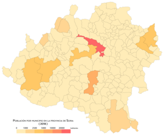
Population by municipality (2018)

Population density by municipality (2018)

Population growth by municipality (1998-2008)
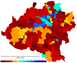
Population growth by municipality (2008-2018)


Population chart 1900-2020
| Graphic of demographic evolution in the province of Soria between 1900 and 2020 |
 |
Population of law (1900-1991) or resident population (2000, 2010) according to population censuses of the INE.Population according to INE's 2020 municipal standards. |
Population chart 1990-2020
| Graphic of demographic evolution in the province of Soria between 1990 and 2020 |
 |
Population of Law (1990-2020) according to population censuses of the INE to 1 January of each year. |
Population graph 1900-2020 excluding the capital
| Graphic of demographic evolution in Soria province excluding capital between 1900 and 2020 |
 |
Population of law (1900-1991) or resident population (2000 and 2010) according to population censuses of the INE. Population according to INE's 2020 municipal standards. |
Evolution of the population of Soria (capital)
| Soria's demographic evolution figure between 1900 and 2020 |
 |
Population of law (1900-1991) or resident population (2000 and 2010) according to population censuses of the INE. Population according to INE's 2020 municipal standards. |
Economy

In addition to the traditional provincial economic sectors of dryland cereal agriculture, the economy of Soria is currently based on tourism (rural, monumental, paleontological, mountain and snow), as well as the energy and industrial sectors, where the agri-food industry and the transformation of wood and furniture manufacturing stand out.
The main industrial hubs of the province are located around the city of Soria, and in Ólvega, Almazán and El Burgo de Osma. Despite the strategic location of the province close to important Spanish cities such as Madrid, Valladolid, Pamplona and Zaragoza, the lack of adequate transport and energy infrastructure has meant that the province has not had sufficient and balanced industrial development. As a reaction to this fact, a citizen movement called "Soria ¡Ya!" which demands, among other things, adequate communication infrastructures for the province, and blames the State for the lack of investment.
Primary sector
Agriculture from Soria has traditionally rested on dryland cereal agriculture. In the 1950s there were a total of 70,000 cultivated hectares, but excessive parceling and lack of mechanization resulted in very low productivity. In 1960, when the primary sector still employed 69% of the workers in the province, 70% of farms used exclusively animal traction. There are currently about 100,000 hectares in the province dedicated to growing wheat and another 100,000 to growing barley.
Cabeza de la Mesta, the main livestock in the Soria province is sheep and in the 1960s there were more than 800,000 head of cattle. Just as churras and Merinos had replaced the variety of black sheep from Celtiberia, since the 1960s the native varieties of Soria mountain cows, pigs and chickens have been crossed or replaced by other more productive varieties.
It is also important to exploit native forest resources to obtain wood, resin and mushroom gathering. Finally, the province has hosted certain mining activity since ancient times (marble quarries in Espejón, iron mines in the Sierra de Toranzo, Ólvega, until the 1970s) that will be expanded in the future, or not, by exploitation. of an important deposit of magnesites in Borobia since the project is currently awaiting the resolution of several judicial appeals due to its effects, among others, on the Manubles river.
Secondary sector

The agricultural sector has a very high contribution to the GDP of the province (10 points higher than the Spanish average). The industrial sector represents a percentage slightly higher than 20% of its GDP. The agri-food industry stands out (flour mills; meat industry, particularly in Ólvega; wineries, including some of the Ribera del Duero designation of origin in San Esteban de Gormaz), of transformation of wood and manufacture of furniture (which has contributed to the maintenance of its forests and the generation of employment) and has an important participation of the auxiliary industry of automotive components.
Tertiary sector
Soria has interesting values for tourism, linked to its own resources. On the one hand, its geographical location in the national territory, between the Ebro and Duero valleys, close to large capitals such as Madrid and Zaragoza, and Navarra, La Rioja and the Basque Country. The province has a small train station Nordic and alpine skiing in Santa Inés.
History

In their lands we find prehistoric remains of unquestionable value, among which are the cave paintings, preserved in different shelters. Two of the most important sites are those of Torralba and Ambrona, paleontological and archaeological sites that correspond to various fossiliferous levels with associated Acheulean lithic industry (Lower Paleolithic), from at least 350,000 years ago.
Celtiberia
During the Iron Age, the province of Soria was part of Celtiberia, a territory in which the Celtiberians lived, considered mainly as Celts. This culture has left archaeological remains of such importance in the province such as those of Numancia, Uxama (Osma), or Termancia (Tiermes), and historical passages as unique as the one known as the Gesta de Numancia.
Basques
There are also more than two hundred Basque place names in Soria, mainly in the north, which indicate the presence of the Basques in the area. Urbión, Larralde, el Acebal de Garagüeta de Arévalo de la Sierra, Garray or Narros are some of these place names.
According to recent epigraphic studies, the presence of the Aquitanian language, the predecessor of Euskera, in the north of the province, and consequently of Basques, predates the imposition of a Celtic and later Latin language in the area, and even predates all the epigraphic findings in Basque in La Rioja, the Basque Country or Navarra. Eduardo Aznar Martínez, author of the book El euskera en La Rioja, carries out an analysis of the inscriptions on tombstones in Basque that appeared in villages of the Highlands, citing names that would be proto-euskaldunes. The word "sesenco", which appears carved next to an image of what a bull would be, for the researcher, is equivalent in Basque to zezenko ("young bull", "steer").
Romans

After the wars of conquest and the subsequent Romanization process, the province belonged to the Conventus Cluniensis of the Roman province of Tarraconensis. The aforementioned cities of Numancia, Tiermes and Ocilis (Medinaceli) stand out from this period.
Muslims
After the fall of the Roman Empire, it was occupied first by the Visigoths and later by Muslims, from whose passage the castles of Medinaceli and Gormaz remain, the largest Caliphate fortress of its kind in Europe.
It is during this time of Muslim rule, in which the province once again becomes the main protagonist of history, since the best-known Muslim warrior, Almanzor, had his headquarters in the province, in the place of Medinaceli; and the places on the banks of the Soriano Duero, constantly passed from Muslim to Christian hands, and vice versa, being practically depopulated. The innumerable watchtowers and defensive towers that dot the province date from this period and which gave the name to Castilla, land of castles. Meanwhile, until the IX and X, inhabited the north of the province of Soria by semi-pagan people with little Christianization. Arabic sources called them barbarians (ajam), instead of using the usual word to refer to Christians (naṣrānī, نصراني).

Kingdom of Pamplona
During the reconquest in the Middle Ages, the northern and eastern part of the province of Soria belonged to the Kingdom of Pamplona since 1016, because King Sancho Garcés III reached an agreement on the limits between the County of Castilla and the Kingdom of Pamplona, leaving for Pamplona the expansion to the south and east, the north-eastern area of Soria and the Ebro valley, among other territories.
In 1127, through mediation, the Pact of Támara was agreed. In this pact, Alfonso the Battler renounced the title of emperor and the borders between the kingdoms of Castile and those of Pamplona and Aragon were delimited with the return of some of the territories to Castile. In this pact, Vizcaya, Álava, Guipúzcoa, Belorado, Soria and San Esteban de Gormaz remained in Pamplona territory.
Castile
Soria became part of Castile in 1134, during the reign of Alfonso VII.
In 1187, Alfonso VIII summoned the nobles and the representatives of the most important cities of Castile to the Cortes in San Esteban de Gormaz, in what (together with the León Cortes of 1188) would be the first example of parliamentarism in the western world.

After the reconquest in the Middle Ages, Soria experienced the greatest splendor of its history, becoming the jewel of the Romanesque that it still is today. With the splendor that Soriano's medieval times represented as a border area between the kingdoms of Castile, Navarra and Aragon.
Almost all the economic activities of the Soriana Middle Ages revolved around wool. Head of several royal glens, Soria controlled the summer shearing of its flocks and the shipment of the precious fleece to Burgos and the northern ports of the Iberian Peninsula. In 1492, the decree of expulsion of the Jews, brought the economic and social decline of Soria. With the union of the kingdoms of Aragon and Castilla, the province ceased to be a strategic enclave. This situation continued during the Modern Age, in which the decline in the profitability of livestock farming put the province in a situation of economic and demographic deterioration.

The Contemporary Age was marked by the continuous armed conflicts in which the Spanish nation participated, which continued to reduce the economic power of the province. The province of Soria went from having nearly two million sheep in the 18th century, to half a million in 1832.
Soria has experienced widespread political, economic and social instability throughout the nation, but which seemed to multiply in those areas of an eminently agricultural nature. These conditions affect emigration and the gradual aging of its population. At present, Soria is recovering the splendor of other times, boosting above all its tourist possibilities, fostered by the uniqueness of its landscapes and its timeless beauty.
History of administrative divisions
The province of Soria was born, like all of them, with the Spanish provincial division of Javier de Burgos in 1833. However, they existed in the Crown of Castile since the end of the century XVI entities of a purely fiscal nature called provinces, devoid of any administrative or legal value and that coexisted with many other different structures. Among them was one based in the city from Soria. These should not be confused with the current concept of province. Later, in the 18th century, the intendancies would be created and finally in the XIX the provinces in the current political sense of the term.
Modern Age

During the XVIII century the municipalities were created, one of them being created with headquarters in the city of Soria. As indicated by the Floridablanca Census, a census document prepared in Spain under the direction of the count of the same name, minister of Carlos III, between 1785 and 1787 and is considered the first Spanish population census prepared following modern statistical techniques, the Municipality of Soria is formed by:
- Barrios de Soria
- Sexmos de la Tierra de Soria: Frentes, San Juan, Arciel, Luvia, Tera
- Alfaro Party
- Aggress Party
- Atienza Party
- Almazán Party
- Aguilar Party
- Berlanga Party
- Osma Burgo Party
- Calahorra Party
- Calatañazor Party
- Caracena Party
- Cobeta Party
- Decision-making Party
- Magana Fountains Party
- Fuentepinilla Party
- Gormaz Party
- Jubera Party
- Magana Party
- Duchy of Medinaceli
- Monteagudo Party
- Osma Party
- Party of Rewards
- San Esteban de Gormaz Party
- San Pedro Manrique Party
- Seron Party
- Merindad de Solpeña
- Suellacabras Party
- Ucero Party
- Yanguas Party
- Villas Eximidas
19th century

At the beginning of the XIX century, the province underwent several changes. In 1802, the populations of the Partido de Logroño became part of the province of Soria, and a new reform of 1812 made three quarters of La Rioja part of the province of Soria. However, after the reform of Javier de Burgos From 1833, which creates all the Spanish provinces in the current political sense of the term and among them the current one of Soria, it now has 10,400 km², a decrease of 3,763 km² when compared to the province in the Old Regime. The territories lost mainly by the province of Guadalajara and the province of Logroño. The territory still included in the province is made up of 540 constitutional municipalities divided into five judicial districts.
| Judicial parties | Peoples | Neighbors | Souls |
|---|---|---|---|
| Aggress | 97 | 6095 | 21 763 |
| Almazán | 104 | 5365 | 20 986 |
| Burgo de Osma | 123 | 5841 | 22 552 |
| Medinaceli | 50 | 3393 | 11 793 |
| Soria | 166 | 9372 | 38 500 |
| Total | 540 | 30 022 | 115 619 |
The province became part of the region of Castilla la Vieja in 1833, and many other nineteenth-century territorial organization plans attached it to it. The one of Patricio de la Escosura of 1847 united it to the region of Burgos (together with Burgos, Santander and Logroño). Francisco Silvela's attempt at territorial organization in 1891 assigned the province of Soria to Aragon (along with Huesca, Logroño, Teruel and Zaragoza).

News
Later, it began to have only three judicial districts: the judicial district of Almazán, the judicial district of El Burgo de Osma and the judicial district of Soria
Culture
Museums
Architecture
- Category: Palaces in the province of Soria
- Category:Churchs of the province of Soria
- Castles of the province of Soria
Routes
- GR-86, Soriano Iberian Path.
- Camino de Santiago
- Camino de Santiago de la Lana
- Cid Road
- Route of the Icnitas
- Route of the Watches
- Footprints of Santa Teresa
- Route of the Templars
Parties
- Fiestas de San Juan o de la Madre de Dios, declared Festival of Regional Tourist Interest of Castilla y León.
- Semana Santa Soriana, declared Festival of Regional Tourist Interest of Castilla y León.
- Days of the Matanza, declared Festival of Regional Tourist Interest of Castilla y León.
- Holy Week of El Burgo de Osma, declared Festival of Regional Tourist Interest of Castilla y León.
- Fiestas de San Pascual Bailón y El Zarrón, declared Festival of Regional Tourist Interest of Castilla y León.
- The descent of Jesus, declared a Regional Tourist Interest Party of Castilla y León.
- The Soldadesca de Iruecha, declared Festival of Regional Tourist Interest of Castilla y León.
- Our Lady of the Virgin of Pino and San Roque, declared Feast of Regional Tourist Interest of Castilla y León.
- Paso del Fuego y Fiesta de las Móndidas, declared Festival of Regional Tourist Interest of Castilla y León.
- Good Friday in Ágreda, declared Festival of Regional Tourist Interest of Castilla y León.
- Toro Júbilo de Medinaceli, declared Festival of Regional Tourist Interest of Castilla y León.
- Fiestas de San Saturio de Soria.
- Festivals of Las Candelas and San Blas de San Leonardo de Yagüe.
- Feasts of Las Móndidas and the Ramo, held in Sarnago, Matasejún and Ventosa de San Pedro.
- Holy Week in Seron de Nágima.
Gastronomy

- Yemas de Almazán
- Patiences of Almazán
- Cost of Soria
- Soria Butter, butter with name of origin.
- Torrezno de Soria, with guarantee mark
- The Pastoral Migas
- The chorizo
- The caldereta
- The roasts of lamb and chochinillo
- The chorizo picadillo
- The Alubia of El Burgo de Osma
- The salted clay and the sweet clay
- Soria Black Truffle
- Hong
- Aggress Cardo
- Lemonade of wine
The province has a native sheep breed: the ojalada.
Notable people
Contenido relacionado
Category:Cartography
Geography of Equatorial Guinea
Zhytomyr Oblast