
Sidi Ifni
Sidi Ifni (Arabic: سيدي إفن) is a Moroccan city and municipality located in the western part of the Sidi Ifni province, in the Guelmim-Río Noun region. On the shores of the Atlantic Ocean, this municipality limits with those of Tiugsa, Amel-lu and Mesti.
It is 163 kilometers by road south of Agadir. Until 1969 it was the capital of the former Spanish territory of Ifni.
Toponymy
.jpg)
Before the city was founded in 1934, the place was called the Amezdog douar. It was also known by the name of the Kabyle Berber tribe Chleuh Ait-Baamarani of El Mesti. Other denominations of the place are Ait Ijelf or Id Brahim Iusf.
According to Kebir Abdemalik, the name Sidi Ifni can be roughly translated from the Bebeber language as lord of the lagoon, referring to the mouth of the Asif n'Ifni river. Next to that site there is a marabout with a green dome in which Chej Sidi Ali, a leader of the Moroccan Darkaoa brotherhood, is buried. Since time immemorial, the locals of Sus have visited the tomb of Sidi Ali n'Ifni, that is, Sidi Ali in the lagoon. The truth is that marabouts are always related to water points, & #34;whether wells, streams, boulevards or fountains, almost always in high places and the opportunity to be buried next to the saint is offered, so we can almost always find a small cemetery in the surroundings".
Due to the circumstances of the Wad Ras treaty, on many occasions, the name of Santa Cruz de Mar Pequeña was used to refer to the town, although this place is actually located in Tarfaya.
Demographics
It has a population of approximately 20,000 people.

Physical geography

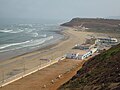
The city is located in a desert area, located on the edge of a narrow plateau, between Jebel (Mount) Bu Laalam and a steep coast, interrupted by the mouth of the Ifni River, which is actually a torrent that only carries water, tumultuously, when it rains in the area (between October and, above all, November and in February/March). A water that stains the coast brown, just in line from the mouth to the south, revealing a strong coastal marine current. Also note the Legzira beach and its red conglomerate cliffs where a stone arch stands out on the beach, after the collapse of its twin arch in 2016.

Climate
According to the Köppen classification, its climate is Bwh, an arid climate. However, the city enjoys a special microclimate, much milder than in the hot interior territory. Very closed fogs usually occur. In 2016, the UN awarded the initiative to capture water from the fog to supply drinking water, like the initiatives developed in the Canary Islands or Chile. However, the proximity of the desert is noted in the low rainfall, in the flora and, from time to time, by the arrival of the sirocco, a desert wind that can suddenly raise the ambient temperature to 50 °C.
History
.svg)
Sidi Ifni Foundation

The city was founded on April 6, 1934, after Colonel Osvaldo Capaz took possession of the area, on behalf of the Government of the Second Spanish Republic. There was only one small construction in the place, a douar called Amezdog, belonging to the Kabyle El Mesti of the Ait-Baamarani Berber tribe,[1] and of which no remains remain today. Spanish sovereignty was recognized by the Sultan of Morocco through the Wad-Ras Treaty, signed on April 26, 1860. For political reasons and contradictory interpretations of the historic location of Santa Cruz de la Mar Pequeña, in 1883 both nations established that Sidi Ifni corresponded to the Castilian stronghold of the XV century of Santa Cruz de la Mar Pequeña to which the Treaty of Wad-Ras.
After the signing of the Treaty of Fez in 1912 and the campaigns of 1934 that culminated in the French conquest of Morocco [2] the Spanish took formal possession of the territory. Pressured by the agreements signed with France in 1912 and with the acquiescence of the tribes who, given the circumstances, preferred the Spanish presence to the French one and the expectation of not having to pay taxes to the sultan, on March 27, 1934 the occupation of Cabo Juby, thanks to satisfactory contacts between Colonel Capaz and representatives of the population of the territory. On April 4, Capaz, after receiving authorization from the Spanish government, embarked on the gunboat Canalejas heading towards Ifni. On that date, a trimotor dropped a letter from Capaz in the souk of the Arbaa de Mesti, announcing the agreements adopted and the upcoming Spanish landing. The event was recounted in this way by Francisco Hernández-Pacheco, who was part of the scientific expedition that toured the territory of Ifni shortly after for the Royal Geographical Society, which was reported in the newspapers of the time such as La Libertad or The Sun:
He landed Capaz on Sidi Ifni beach on April 6 [of 1934], accompanied only by Lt. Lorenzi and the signal end of the ChannelsFernando Gómez Flórez. At the meeting of the Spanish boat, a hurdle with indigenous people came out of the beach, to which Capaz and his people transferred, disembarking all of them happily on the beach. He addressed Capaz to a group of indigenous people who were waiting for him, of which some notables were highlighted, who offered the Colonel as a welcome sign a bowl of bitter milk. Then, on horseback, he climbed to the top of the coastal zone and in the immediate land of Amedog (sic) he ate. During the meal came some groups of indigenous and remarkable, to which Capaz explained plainly and clearly the purposes and intentions of Spain. The indigenous marched after the meal, holding some meetings, in which it was widely discussed. The following morning they informed Colonel Capaz of Ifni's agreement to join Spain.Francisco Hernández-Pacheco, Physical and geological traits of the territory of Ifni.

Together with Amezdog, the Spanish presence was formalized in a ceremony attended by the notables Ait-Baamaranis and Colonel Osvaldo Capaz.
In just three years it went from an occasional tent camp, and the occasional barracks, to the construction of six hundred houses or buildings that housed Army of Africa units such as the Ifni Gunners Group, created on June 9 of 1934 in which a third of the officers were natives. The population experienced spectacular growth in just a few years. During the Spanish civil war six tabors of Ifni shooters were transferred to the peninsula to intervene in the battles, approximately 1,000 combatants of this unit died in the war. By 1940, the urban structure was already well advanced in its streets, squares, and main buildings. From 1940 to 1950 the population grew from 700 to 8,000 inhabitants. In 1947 the minor incident of the rebellion of the Isbuia Berber tribe occurred.[3]

Ifni-Sahara War 1957-1958
After the independence of Morocco, Moroccan irregular forces attacked the territory between November 1957 and July 1958. The attacks began on November 23, 1957, starting the Ifni War, which took place in the territories of Africa Western Spanish (AOE). However, the city was supplied by sea and air and protected by outposts. Initially, a good part of the military troops were fundamentally replacement soldiers, in addition to a very smaller number of indigenous people, especially from the Ifni Shooters Group and the Territorial Police. They were disarmed, demobilized, and promptly replaced. Except for a frustrated plan by the Moroccan irregular forces to finish off the Spanish officers, the slight initial incidents and some attacks, Sidi Ifni was not directly affected by the military events. These were developed in the interior of the territory. On the Spanish side, it was finally decided to establish a denser defensive perimeter that was more difficult to infiltrate and, moreover, easier to sustain and supply, near the city of Sidi Ifni (between 8 and 10 km from the city center, according to the area) abandoning most of an arid territory that would have been much more expensive to defend without appreciable advantage. These defensive positions, quite numerous, and the dirt tracks that connect them, are still perfectly visible. By the end of the conflict most of the interior territory of Ifni had been abandoned, destroying the detachments liberated during the war. The military contingent withdrew around SIdi Ifni, where a defensive perimeter was established that lasted until 1969. In 1958 it lost its status as the administrative capital of Spanish West Africa. Ifni was then declared a Spanish overseas province, with Sidi Ifni as the capital.
In 2007 Spain promulgated Law 39/2007, of the Military Career, giving recognition to replacement soldiers who had completed their mandatory military service in Ifni during the Ifni war. Thanks to the internet, there is currently a strong associative movement of veterans of military service and the Ifni war in Spain.
A fundamental aspect of Spanish political management in the area was the recognition and respect for the uses and customs of the Ait-Baamarani population, as well as their religious beliefs. For example, Spain provided the means for the construction of mosques and for the Koranic education of Muslim schoolchildren. The prohibition of any kind of Christian religious proselytism was a perfectly known and respected principle. In 1961, an airstrip was built, which had auxiliary facilities, a control tower and cargo and passenger terminals, although its traffic was modest, representing a third of that of El Aaiún. In 1965 it was completed, after On the other side of the Ifni River, the urban expansion of the city known as Barrio General Agulla or Colominas, by the name of the Spanish company that built the neighborhood. In 1967 the cable car port was inaugurated.
Incorporation into Morocco in 1969
On June 30, 1969, the Spanish government ceded what it kept from Ifni to Morocco, by virtue of the Retrocession Treaty signed in Fez on January 4, 1969, thus making the retrocession effective. After that, a difficult process of adaptation began, aggravated by an acute economic crisis and the imposition of the French-speaking administration. For years the main source of wealth had revolved around the existence of an important Spanish military colony in a city that had the infrastructure and equipment typical of a modern provincial capital. Within the period of violence known as years of lead, on February 2, 1972, King Hassan II suffered an attack during the inauguration of the soccer field.
On May 30, 2008, a large number of unemployed youths blocked the entrance to the port of Sidi Ifni, protesting their situation and that of the region, claiming that, in thirty years, not only had no investments been made, but the existing ones, such as the hospital, were in a precarious situation. These were joined by dozens of people in a demonstration that toured the streets of the town. The protests were repressed by the Moroccan police and the treatment of the information by the Moroccan government press agency was criticized. In 2009 the province of Sidi Ifni was split from the province of Tiznit, making Sidi Ifni the capital of the province. Within Spain-Morocco relations, after the descendants of Spanish Ifneños were not contemplated in the Spanish law that does grant nationality to Sephardim, in July 2016 the protests were reproduced. The demonstrators occupied the building of the old Spanish consulate with red flags and, in addition to protesting the lack of investment, they demanded to be able to obtain Spanish nationality for being descendants of Spanish Ifneños.
Currently it is a town with an incipient tourism related to surfing, the natural monument of the arch, the beach of Legzira and the buildings from the colonial period.
Economy
The economic base of the city is fishing and the cultivation of argan and cactus (prickly pear), from which valuable oils are extracted, mainly for the cosmetics industry, and other food products. There is an incipient tourism industry, mainly sun and beach tourism, nature tourism and sports tourism (surfing).
Cultural heritage and urban structure
The first cable car port, inaugurated in 1967 by the Spanish, was a unique and original solution to overcome the difficult conditions of the coast. It consisted of a dock linked to the coast by a cable car 1,400 meters long, allowing medium-tonnage ships to load and unload. Near that cable car there is today an acceptable fishing port, exactly where an old Spanish project foresaw that was discarded due to the risk of grounding.
The Spanish-era airfield is abandoned. Actually, it is historically the second Spanish airfield in Sidi Ifni, since the first one was located on a small runway, which still exists, in the northwest corner of the current airfield. What is extraordinary is that this field occupies a good part of the plateau on which Sidi Ifni sits, and that its limits coincide with busy streets except at its southern end. For all these reasons, and the modern demands of air traffic, it will be difficult for the old airport to return to operation. Its approximate dimensions, two thousand meters long by five hundred wide, one million square meters, would seem like the natural expansion of the city which, however, has grown at the expense of the foothills and the coastal cliff.
In Sidi Ifni, the traces of the Spanish past are still very visible. Notable are the Plaza de Hassán II (formerly Plaza de España) with a fountain and Andalusian-style tiles, the Spanish consulate or paymaster's office in Sidi Ifni (today closed) and the Municipal Palace.[4] The style used is characterized by the influence of the constructions of the protectorate of Emilio Blanco Izaga [5] called Riffian style with geometric decoration inspired by the khasbas of southern Morocco, as well as by the use of art deco elements, including the aerodynamic, neo-Andalusi, functionalism (hospital chapel, today a pharmacy warehouse) and Canarian regionalism. In addition, point out other examples such as the church of Santa Cruz (now the Palace of Justice), the Comandancia de Marina (currently a restaurant), the Marine Infantry barracks (currently a hotel), the lighthouse and the Royal Palace (formerly the General Government).. The barracks that used to be the No. 1 Ifni Shooter Group and the Mixed Group are in use, occupied by the Royal Moroccan Army (GEB and GAR) and the new barracks of the 1st Ifni Police Company No. 1 is the headquarters of the Regional Civil Protection Division. Other buildings from the Spanish period are abandoned, such as the old Police headquarters, the jail, the recruit camp of the Ifni Shooters Group No. XIII Independent Flag of the AOE) or the Avenida cinema. In addition, on the outskirts of Sidi Ifni, the Ifni Shooters No. 2 barracks, the Aman U Ali fort, the Id Nacus camp, Coraima facilities, or the Id Mehais-Xaraff position are also in a dilapidated state.

Royal Residence, Old Governor's Palace

Barandilla de Sidi Ifni

Palace of Justice, ancient church of Santa Cruz

Sidi Ifni Hospital

Hotel Belle Vue, former Marine Corps headquarters
Campsite Sidi Ifni, old swimming pool Tutor


Spanish is studied at the Sidi Ifni Cultural Youth Center and various language schools.
Article 7 of the Treaty of Fez of 1969 between Morocco and Spain, regarding the Ifni Territory, and in relation to the defense and protection of the Spanish and Haquetía languages, states: "The Moroccan Government will not object to the maintenance of existing Spanish cultural and educational institutions in the territory and will provide facilities for the opening of those that the Spanish Government may consider convenient".
Celebrity children
Contenido relacionado
Tennessee
The town of the river
Paterna de rivera