Selenga River
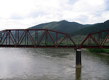
The Selengá River (also transliterated as Selenge or Selengue) (Mongolian: Сэлэнгэ, Selenge mөrөn; in Buryat, Сэлэнгэ мүрэн; in Russian: Селенга) is a long river in northern Mongolia and south-central Asiatic Russia or Siberia, which originates by the confluence of the Ider and Delgermoron rivers and flows in a northeasterly direction until it empties into Lake Baikal. It has a length of 1024 km, but is part of the Yenisei-Angará-Lake Baikal-Selengá-Ider river system, which reaches 5539 km and is considered the fifth longest river in the world, after the Amazon, Nile, Yangtze and the Mississippi-Missouri. It drains a hydrographic basin of 447,000 km².
The main city that this river crosses is Ulan-Ude, capital of the Republic of Buryatia, in Russia. From November to mid-May, the river is frozen. It is navigable from April to November to Sukhbaatar (19,224 inhabitants in 2007), the capital of the Mongolian aymag of Selengué.
Geography


The Selengá River rises in Mongolia, about 375 km (as the crow flies) southeast of the southern tip of Lake Baikal and about 150 km north of the Jangái Mountains, from the union of three rivers: Delgermörön (445 km), Ider (452 km) and Bügsiin Gol.
It first runs west through the Mongolian aymag of Selengué. It passes through the towns of Dugang, Hutag and Nammag and then receives on the left the first of its important tributaries, the Eg River (475 km) which arrives from the northwest. It turns increasingly towards the northeast, and passes through Banga, Büdüun and near Suhe-Bator, receiving on the right the longest of its tributaries, the Orkhon River (1124 km), which arrives from the south and through which It can be reached by sailing to the capital of Aymag, Sujbaatar. It takes the river north and reaches the Russian border after passing through Tsagan-Arat and, already in the Russian republic of Buratia, it reaches Kiajta, where it has an average flow of 23 m³/s in February and 601 m³/s in August.
It turns towards the northeast and continues through Zanúbino and Debé, after which it receives, on the left, the Dzhidá River, coming from the east. It continues through Ubur-Dzokoy, Máriino, Yenjor, Strelka, Zuy-Zakámenka and Ust-Jilok, where it receives on the right the Khilok River (840 km), which arrives from the south. It continues through Kibálino, Ganzúrino, Kordón, Selengá, Sayantuy, Poselie and reaches Ulan-Udé, the capital of Buryatia and the most important city it passes through (359,391 inhabitants in 2002). Here it receives, on the right side and arriving from the west, the waters of the Uda River (467 km).
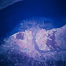
It continues in a northerly direction passing through Zarechny, Útochkino and Mostovoy, where the flow is already 951 m³/s. It continues through Burdukovo and Tataúrovo, where it turns abruptly to the west; It then passes through Iliinka, Yugovo, Tarakanovka, Bryansk and Beregovaya, where it begins a wide curve towards the northwest, Kabansk, Zhilino and Tvrogovo, which begins the area of the large delta (546 km²) in which it empties into Lake Baikal. In the delta area there are the towns of Selenguinsk and Korsakovo.
Tributaries
The Selená River has the following main tributaries:
- In Mongolia:
- Chuluut river (right margin), with a length of 415 km and a basin of 10,750 km2;
- river Delgermörön (left), with a length of 445 km and a basin of 26,640 km2;
- Eg river (or Egiin Gol) (left), emissary of Lake Ubsugul, with a length of 475 km and a basin of 49.100 km2;
- River Orjón (right), with a length of 1,124 km and a basin of 132,835 km2, with its subfluent the Tuul River (right), which baths Ulán Bator, with a length of 704 km and a basin of 48,840 km2;
- in Russia (Buriatia):
- Dzhidá river (left), with a length of 558 km and a basin of 23,500 km2, and with its subfluents the Khamneï rivers (170 km) and Jeltoura (190 km);
- River Témnik (left), with a length of 314 km and a basin of 5,480 km2;
- Chikói river (right), with a length of 769 km and a basin of 46,200 km2, with its subfluent the Menza River (337 km and 13,800 km2);
- Jilok river (right), with a length of 840 km and a basin of 34,500 km2;
- River Uda (right) that flows in Ulán-Udé, with a length of 467 km and a basin of 34.700 km2, with its subfluents the rivers Ona (160 km), Kourba (175 km), Khoudoun (210 km) and Brianka (110 km);
- River Itantsa (right), a short 110 km river and a 2300 km2 basin.
Hydrometry
The flow of the Selengá has been observed for 12 years (1980-91) in Mostovói, a town located about twenty kilometers downstream from the city of Ulan Ude, capital of Buryatia, and about 150 km from its mouth into the Lake Baikal.
In Mostovoy, the average annual flow observed during that period was 951 m³/s, for a drained area of 440,200 km², almost the entire river basin.
The runoff level in the river basin reached 68 mm per year, which can be considered quite low.
The Selengá River is an abundant river, but very irregular, and has two well-marked seasons.
High waters begin from May to October inclusive. From the beginning of November, the river's flow drops drastically, but it maintains a satisfactory flow of water during the low season, which takes place from November to April. The average monthly flow observed in February (minimum dry season) is 86.5 m³/s, approximately 25 times lower than the average in August (2,215 m³/s), which reflects the great amplitude of seasonal variations. In the 12-year observation period, the minimum monthly flow was 34 m³/s, while the maximum monthly flow amounted to 4,101 m³/s.
| Average monthly flow of the Selengá River at the Mostovói hydrometric station (Data calculated in 12 years, 1980-91, in m3/s) |
 |
Selenga Delta Ramsar Site

An area of 121 km² of the Selengá River delta, which is 540 km² and the largest on Lake Baikal, was declared Ramsar site number 682 in 1994. It is part of the Lake Baikal UNESCO World Heritage Site, of 88,000 km², is also a nature reserve, zakáznik and nature sanctuary, and is part of the Anatidae Site Network (Anatidae Site Network). The Ramsar site includes the shallow water zone of Lake Baikal, the river branches and dead meanders. The vegetation consists of reed beds, regularly flooded grasslands and shrubby willows. It is an example of a unique wetland threatened by endemic species of fauna and flora. In the area there are vast concentrations of aquatic and migratory birds. The total population of ducks (ducks, geese and swans) varies between 20,000 and 138,000 individuals. More than 5 million birds pass through the delta in the fall and 7,300 to 18,300 stay. Human activities include hay harvesting, livestock grazing, commercial and sport fishing, muskrat trapping, waterfowl hunting, and recreation. River regulation produces changes in the hydrological regime, and the rise in the level of Lake Baikal is the greatest threat to ecosystems.
Contenido relacionado
Alba Coke
Flower boxes
Population density