
Scandinavian alps

The Scandinavian Alps, Scandinavian Mountains or Scandes (in Swedish: Skanderna, Fjällen or Kölen; in Finnish: Köli; in Norwegian: Kjølen) are a mountain range that extends the entire length of the west coast of the Scandinavian peninsula. They cover most of Norway, northwest and west Sweden, as well as a very small part of the far north of Finland. It is one of the most important mountain ranges in Europe, extending from southwest to northeast along 1700 km, with a maximum width of 300 km. The mountain range has two high-altitude areas, one in southern Norway—around Jotunheimen, where Galdhøpiggen (2,469 m), the highest point, is located. of the mountain range and the country in question—and another in the north of Sweden—with the Kebnekaise (2102 m), also the highest point in the country—. The highest point in Finland is also in the mountain range, the Halti (1328 m).
The Scandinavian Alps lie at the level of the ancient Caledonian mountain range, which was formed 400 million years ago during the collision between the paleocontinents Laurentia (now North America) and Baltica (now Scandinavia). This mountain range was probably comparable in width to the present-day Himalayas, but was almost completely flattened by erosion in the millions of years following its formation. The current relief is much more recent, linked to a tectonic uplift of all the continental margins of the northern Atlantic Ocean in the Paleogene and Neogene (that is, from 60 million years ago). This elevated peneplain was later eroded by Quaternary glaciers, sculpting the current relief. This erosion was particularly important on the western slope of the mountain range, forming deep glacial valleys, many of which descend below current sea level, constituting the famous Norwegian fjords.
The climate of the mountain range is very asymmetrical. On the western slope it is very oceanic, with very mild temperatures for the latitude and significant rainfall, while the east is more continental. This climate allows the persistence to the west of a large number of glaciers, several of which are the largest in continental Europe, such as Jostedalsbreen. Those climatic differences also strongly affect the vegetation, with rich moist deciduous and coniferous forests on the western slopes contrasting with the poorer taiga on the eastern side. The alpine tundra is characterized by meandering birch forests on the subalpine floor. It is the best preserved environment in the mountain range, with a large number of protected areas, both national parks and nature reserves.
The mountain range has been populated since the glaciers retreated 10,000 years ago. The first inhabitants lived essentially by hunting reindeer. In the south, with the arrival of the Indo-European culture, agriculture and livestock farming began, with a pattern of transhumance. The people of the northern part of the mountain range, the Sami, have remained closely linked to the reindeer, although they have replaced hunting with herding, also following a transhumance scheme. With the formation of the Scandinavian nations around the year 1000, communication routes began to develop through the mountains, although these had a terrifying and dangerous character in the eyes of the populations. It was the metal deposits in the mountain range that will gradually bring people to the mountainous areas and develop the infrastructure there. However, until the 18th and 19th centuries the mountain range was not explored and mapped, which allowed the beginnings of tourism. This focused first of all on hiking in a still very wild nature; Since the 1950s, constantly growing winter tourism has been added. The XX century also marks the beginning of the exploitation of hydroelectric energy, which represents a very significant part in the energy balance of Sweden and especially Norway.
The mountain range is divided into three groups, the Kjølen, which separates Sweden from Norway, the Dofrines Mountains, which divide Norway, and the Tullians, in the southern region.
Toponymy

The range of mountains that extends along the Scandinavian peninsula has only recently been seen as a single mountain range. This is partly due to the fact that the Scandinavian Alps rise gradually from the plains of Eastern Scandinavia, not forming a wall visible from afar like other mountain ranges such as the Alps. Therefore it was never perceived as a single entity and only subsets of the mountain range (the Jotunheimen or Dovrefjell massifs) and individual mountains were named. For example, the The northern part of the mountain range between Norway and Sweden was called Kjølen (Norwegian) or Kölen (Swedish), meaning "the keel", because the profile of the mountains resembles to the overturned keel of a ship. In general, mountains were simply called fjell or fjäll, which literally means 'mountain'. In the 1940s, Swedish geologist Erik Ljungner proposed the name Skanderna, in Spanish "the Escandes", to have a name similar to that of the Alps or the Andes. This name has become common in Swedish, and also in French or English, for example Geologists also sometimes use the name "Scandinavian Caledonians", since the current range extends in approximately the same place as the ancient Caledonian range. To alleviate the lack of a name, the Norwegian Geological Society launched a competition in 2012 to find the best name for the mountain range. The name selected, among more than 5,000 suggestions, was Nordryggen, from rygg, which means 'crest' or 'vertebral column', and nord which denotes the position and direction of the mountain range. We will have to wait to know if the name prevails in popular culture.
In French and Spanish, several names have been used to describe the mountain range. One of those names, less used, is "Dofrines Mountains", derived from the Dovrefjell massif. The two most used names are "Scandes" and "Scandinavian Alps".
Geography
Situation

The Scandinavian Alps extend, following a main SSW-NNE axis, along the west coast of the Scandinavian Peninsula, of which they form the spine. They continue in Norwegian Lapland through Troms County to end in Finnmark. However, a small part of the northern part of the mountain range is located in Finnish territory. With a length of 1700 km it is the second longest mountain range in Europe after the Ural Mountains. The mountain range is delimited to the south, west and north by maritime extensions: the Skagerrak, the North Sea, the Norwegian Sea and the Barents Sea. On the other hand, its delimitation towards the east is relatively difficult, since the relief changes very gradually. From west to east, the landscape changes from an alpine landscape to a pre-alpine landscape, with some isolated peaks, then follows an almost undulating landscape. to the Baltic Sea. A boundary called odlingsgräns (literally 'crop edge') is sometimes used as the border of the mountain range. #39;), which represents the boundary between arable land and non-arable land. Delimitation issues aside, the mountain range covers most of mainland Norway, as well as northwestern Sweden (20% of the area of the country). The mountain range, in fact, has historically served as a natural border between Norway and Sweden, which explains why the layout of the northern section of the border between these two countries passes through the massif.
Topography
Geomorphology


The Scandinavian Alps are made up of two high-altitude regions (up to more than 2000 m), one in the south and one in the north, separated by an area lowest altitude (up to 1200 m) at the height of the Trondheim Fjord. The southern part, the widest (up to 300 km), is dome-shaped centered on the Jotunheimen massif, which includes most of the highest peaks in the range, especially the highest, Galdhøpiggen (2469 m). The Jotunheimen area itself is surrounded by other high massifs, such as the Hurrungane, the Breheimen, the Reinheimen, the Dovrefjell and the Rondane. This area is It extends northeast to the Sylarna and Helagsfjället massifs on the Swedish border, and to the south to the vast Hardangervidda plateau and gradually to the sea. The northern part of the Scandinavian Alps is longer and culminates in the massifs of Kebnekaise (2102 m) and Sarek.
Between the peaks of the massif a network of valleys develops that can descend to 300 m above sea level in the east, but in the west are sometimes found far below sea level. Thus, the western coast of Norway is deeply dissected by a large number of fjords: glacial valleys invaded by the sea. The largest of these, the Sognfjord, is It extends almost 200 km inland. These fjords and the numerous islands near the coast make the total length of the Norwegian coast 83,281 km, that is, twice the equatorial perimeter of the Earth.
The topography of the mountain range is often divided into several relief categories based primarily on local relief, that is, the maximum altitude difference in a small area. Areas in which the local relief is more pronounced (altitude differences of more than 700 m) are classified as alpine areas: these are in particular the higher elevations (Jotunheimen, Sarek-Kebnekaise) and the coastal area deeply carved by valleys and fjords. The local relief sometimes exceeds differences in height of 1500 m there and much larger if the submerged part of the fjords is considered, which can thus reach 2800 m in the Sogn Fjord. The areas of local relief most moderate (slopes between 400−700 m) form the majority type of relief outside the coastal zone. This landscape is mainly composed of rounded peaks and wide valleys Finally, the mountain range includes a certain number of plateaus, witnesses of the ancient peneplain that was the region before its tectonic uplift. The largest of these plateaus, Hardangervidda, is the largest mountain plateau in Europe. In the areas More peripheral areas of the mountain range, the landscape becomes undulating, flat but with some isolated peaks (monadnock).
Subdivisions


In the book Scandinavian Mountains, Peter Lennon proposed dividing the mountain range into six zones, each in turn subdivided into several domains. However, these subdivisions do not cover the entire mountain range, neglecting in particular its southeastern part.
| Area | Dominion | Completion point | Altitude | Legend |
|---|---|---|---|---|
| Sweden Arctic | Kebnekaise | Kebnekaise sydtopp | 2102 m | A1 |
| National Parks of Padjelanta and Stora Sjöfallet | Akka Stortoppen | 2016 m | A2 | |
| Sarek National Park | Sarektjåkkå Stortoppen | 2089 m | A3 | |
| Arctic Norway | North | Adjit | 1408 m | B1 |
| Troms and Lyngen | Jiehkkevárri | 1833 m | B2 | |
| Lofoten and Vesterålen | Møysalen | 1262 m | B3 | |
| Sulitjelma – Blåmannsisen – Tysfjord - Narvik | Suliskongen | 1907 m | B4 | |
| Svartisen – Saltfjellet – Okstindan – Beiarn | Oksskolten | 1916 m | B5 | |
| Highlands of the centre | Børgefjell and Jämtland and Västerbotten mountains | Norra Sytertoppen | 1768 m | C1 |
| Sylarna Group | Helagsfjället | 1796 m | C2 | |
| Fjord chain | Trollheimen | Store Trolla | 1850 m | D1 |
| Romsdal | Store Venjetinden | 1852 m | D2 | |
| Sunnmøre and Reinheimen | Gråhø i Lesja | 2014 m | D3 | |
| Jostedal – Breheimen – Ålfot | Hestbrepiggan | 2172 m | D4 | |
| Stølsheimen and Voss/Mjølfjell | Stiganosi | 1761 m | D5 | |
| Central mountains | Rondane and Dovrefjell | Snøhetta | 2286 m | E1 |
| Jotunheimen | Galdhøpiggen | 2469 m | E2 | |
| Hallingskarvet and Filefjell | Folarskardnuten | 1933 m | E3 | |
| Highlands of the South | Hardangervidda | Hardangerjøkulen | 1861 m | F1 |
| Rogaland/Setesdal | Kistenuten | 1647 m | F2 |
Main summits
The ten highest mountain peaks in Scandinavia are all located in Norway: eight in the province of Oppland and the other two in Sogn og Fjordane. There are also 83 peaks of 2200 m and all of them are in Norway.
In Sweden there are twelve peaks above 2000 m (or 13 depending on how you define a peak): eight of them are in parks nationals of Sarek and Stora Sjöfallet and the other four are further north, in the Kebnekaise region. All mountain names come from Sami, although they are written in the more common Swedish spelling.

- Higher Picos de Norway
- 2469 m: Galdhøpiggen (Jotunheimen) (Oppland)
- 2464 m: Glittertind (Jotunheimen) (Oppland)
- 2405 m: Skagastølstind Store (Jotunheimen) (Sogn og Fjordane)
- 2387 m: Styggedalstinden this (Jotunheimen) (Sogn og Fjordane)
- 2373 m: Skardstinden (Jotunheimen) (Oppland)
- 2369 m: Vesle Galdhøpiggen (Jotunheimen) (Oppland)
- 2368 m: Surtningssue (Jotunheimen) (Oppland)
- 2364 m: Memurutinden Store (Jotunheimen) (Oppland)
- 2351 m: Jervvasstind (Jotunheimen) (Oppland)
- 2348 m: Sentraltind (Jotunheimen) (Oppland)

- Higher Picos de Sweden
- 2104 m: Kebnekaise sydtopp (Kebnekaise)
- 2097 m: Kebnekaise nordtopp (Kebnekaise)
- 2089 m: Sarektjåkkå stortopp (Sarek)
- 2076 m: Kaskasatjåkka (Kebnekaise)
- 2056 m: Sarektjåkkå nordtopp (Sarek)
- 2043 m: Kaskasapakte (Kebnekaise)
- 2023 m: Sarektjåkkå sydtopp (Sarek)
- 2015 m: Akka Stortoppen (Padjelanta and Stora Sjöfallet)
- 2010 m: Sarektjåkkå Buchttoppen (Sarek)
- 2005 m: Pårtetjåkkå (Sarek)
- 2002 m (6568 feet) Palkatjåkka (Swedish Lapland)
Other Swedish mountains popular with skiers, mountaineers and hikers are:
- in Lapland: Sulitelma (1860 m) and Norra Storfjället (1767 m)
- in Härjedalen: Helagsfjället1796 m)
- in Jämtland: Templet1728 m), Lillsylen (1704 m) and Åreskutan (1420 m)
- in Dalarna: Storvätteshågna1204 m) and Molnet (1191 m)
- Higher Picos de Finland

- 1324 m: Halti (extreme north) (Finish Lapland and Norwegian province of Troms)
- 1317 m: Ridnitsohkka (north) (Lapland)
- 1285 m: Kiedditsohkka (north) (Lapland)
- 1240 m: Kovddoskaisi (north) (Lapland)
- 1239 m: Ruvdnaoaivi (Laponia)
- 1190 m: Loassonibba (northern) (Lapland)
- 1150 m: Urtasvaara (Laponia)
- 1144 m: Kahperusvaarat (Laponia)
- 1130 m: Aldorassa (Laponia)
- 1100 m: Kieddoaivi (Laponia)
In addition, there are six ultra-prominent peaks in the mountain range, some of which are present in one of the above listings:
- 2372 m: Galdhøpiggen (Jotunheimen, Norway)
- 1754 m: Kebnekaise (Kebnekaise, Sweden)
- 1741 m: Jiehkkevárri (Lyngen, Troms, Norway)
- 1675 m: Snøhetta (Dovrefjell, Rondane, Norway)
- 1576 m: Store Lenangstind (Lyngen, Troms, Norway)
- 1519 m: Sarektjåkkå (Sarek, Sweden)
Finland's largest independent prominence is in Taivaskero, with 807 m prominence.
Climate


The climate of the mountain range presents important contrasts due to the combined effects of latitude, altitude and exposure to oceanic influences. The climate there is generally cold, which is explained by the fact that the mountain range is completely above parallel 58° North. This phenomenon is partly compensated in summer by the length of the day: including twilight, days last 22 hours during the summer solstice at the latitude of Oslo, and north of the Arctic Circle, there are up to two months of continuous daylight that will heat up the short summer. Additionally, certain stretches of the mountain range, particularly along the Atlantic coast, enjoy a notable mildness despite their latitude, tempered by the ocean current of the Gulf Stream. The influence of the ocean on average annual temperatures is estimated at 12 °C. This effect is mainly important during the winter months: one of the most obvious examples is the southern tip of the Lofoten Islands, which is the northernmost place in the world where the average temperature is positive throughout the year. On the contrary, the eastern part of the mountain range presents much more marked temperature differences, although the climate is not yet completely continental. Thus, although it benefits from an average temperature of 10−12 °C< /span> in summer, winter temperatures drop to −16 °C on average, with a record of −52.6 °C recorded in Vuoggatjålme, in Swedish Lapland. Topography also greatly affects temperature with a fairly pronounced foehn effect that significantly warms the east of the mountain range. Finally, temperature Annual average varies between 6 °C along the southern and western coast of Norway and − 6 °C on the highest peaks of the mountain range.
The prevailing westerly winds provide gentleness to the Norwegian coast, but also significant rainfall. This can exceed the annual 2000 mm on the western side of the mountain range, while they are of the order 450−550 mm on the eastern slopes of Swedish Lapland due to orographic shadowing. These precipitations can, due to the temperatures, falling as snow, up to 50% of the total precipitation in the northeast. In those regions the first snow falls in October and the snow cover can last until June. On the south coast, the snow cover lasts less than 50 days.
Hydrography


Most of the waterways of the Scandinavian Alps run on both sides of the mountain range from its watershed, while at the southern end, the valleys form a radial hydrographic network. The main watershed between The Atlantic Ocean and the Baltic Sea roughly coincide with the border between Norway and Sweden throughout the northern part of the mountain range. This line was initially much closer to the Norwegian coast, as tectonic uplift took place mainly on the coast. However, regressive erosion caused by westward-flowing rivers was greater than that caused by eastward-flowing rivers, as was glacial erosion during the Quaternary. Consequently, there was a progressive capture of streams, visible in several places with watercourses mainly heading E-W that eventually join a river heading W-E. There are also some rare exceptions with rivers that cross the mountain range, such as the Altaelva River, which thus creates a deep canyon. This phenomenon is generally interpreted as a consequence of erosion by superposition of the river during the uplift that gave rise to the surrounding reliefs.
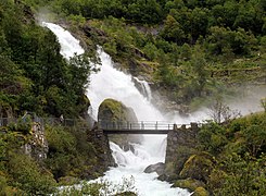
The hydrography is particularly asymmetric between the east and west of the mountain range. The valleys to the west of the mountain range are generally short, deep and steep, and the hydrographic basins are generally not very extensive. Due to the steep slopes, the rivers on the western slope form a large number of waterfalls, several of them including The highest waterfalls in the world. Norway has 41 falls over 400 m, notably Vinnufossen, the highest in Europe and among the ten highest in the world with a total vertical drop of 860 m< /span>. On the contrary, the valleys on the eastern slope are softer, shallower and above all much longer. Despite the greater contribution of precipitation on the western slope, this topographic characteristic explains why the rivers of The eastern slopes are the ones with the greatest flow. Thus, most of Scandinavia's main rivers originate in the Scandinavian Alps and flow east through valleys that are often almost parallel. The main rivers, in terms of flow, are the Glomma (704 m³/s,) the Göta älv/Klarälven (565 m³/s), the Luleälven (506 m³/s), the Ångermanälven (500 m³/s), the Indalsälven (455 m³/s) and the Umeälven (443 m³/s).
The hydrological regime of most rivers is of the nival or nivo-glacial type, marked by a minimum flow in winter and a maximum in spring and early summer with the thaw. A second peak, often weaker, appears with significant autumn precipitation. At the level of the southwest coast of Norway, the high ocean humidity and relative gentleness result in a more constant flow throughout the year, even in winter.

A large number of lakes dot the waterways in the mountains, as well as at their foot. Some of them are small mountain lakes, scattered throughout the mountain range, particularly on the large plateaus, but The most important are found in the large valleys of the eastern foothills, formed by the deepening of glaciers. The main lakes of this type are, from north to south: Torneträsk (330 km²), Akkajaure (260 km²), Hornavan (262 km²), Storsjön (456 km²), Femunden (203 km²), Mjøsa (369 km²) and Randsfjorden (140 km²). There are also some lakes of this type in the west of the mountain range, often in line with the network of fjords. Sometimes they reach great depths: the Hornindalsvatnet (50.42 km²) is the lake deepest in Europe, with 514 m (at an altitude of 53 m).
The Scandinavian Alps have many glaciers, some of the largest in continental Europe (excluding here the glaciers of Iceland, Svalbard and Novaya Zemlya). The accumulated area of all these glaciers is 2900 km²; the largest are found on the peaks near the Norwegian coast, where rainfall is greater, despite higher temperatures. The main glaciers of the mountain range, by surface, are the Jostedalsbreen (487 km²), the Vestre Svartisen (221 km²), the Søndre Folgefonna (168 km²), the Østre Svartisen (148 km²), the Blåmannsisen (87 km²) and Hardangerjøkulen (73 km²). The balance between temperature and the amount of rain explains the fact that during the 20th century some of these glaciers have grown in volume during certain periods, since the increase in precipitation compensates for the greater melting due to rising temperatures due to global warming. However, throughout the century, glacial retreat dominates and this is especially true in the century XXI where there is no recovery period.

The Bøyabreen, a glacial language of the Jostedalsbreen.
![El Briksdalsbreen, otra lengua del Jostedalsbreen. El glaciar todavía cubría completamente el lago en 1997.[27]](https://upload.wikimedia.org/wikipedia/commons/thumb/5/53/Briksdalsbreen_with_glacial_lake%2C_Sogn_og_Fjordane%2C_Norway%2C_2013_June_-_2.jpg/271px-Briksdalsbreen_with_glacial_lake%2C_Sogn_og_Fjordane%2C_Norway%2C_2013_June_-_2.jpg)
The Briksdalsbreen, another language of the Jostedalsbreen. The glacier still covered the lake completely in 1997.
Cascada sobre el Briksdalselva, fed by the melting of the Briksdalsbreen.

![El Briksdalsbreen, otra lengua del Jostedalsbreen. El glaciar todavía cubría completamente el lago en 1997.[27]](https://en.wikipedia.org/wiki/Archivo:Briksdalsbreen_with_glacial_lake,_Sogn_og_Fjordane,_Norway,_2013_June_-_2.jpg)

Geology
The geological history of the Scandinavian Alps is long and relatively complex. If the current relief is recent (from the Cenozoic, around 60 million years ago), the mountain range clearly bears the mark of a succession of events that began ago. more than 450 million years. This history can be divided into six stages: the pre-Caledonian orogeny stage, the Caledonian orogeny itself, a post-orogeny stage, a phase called paleica, a phase of tectonic uplift and a phase of glacial erosion.
Caledonian mountain range

At the end of the Precambrian, about 570 million years ago, the paleocontinent Baltica, which corresponds among others to modern-day Scandinavia, was a peneplain. That continent was bathed by the Iapetus Ocean, like the continent Laurentia, among others, corresponding to present-day North America and Greenland. The first notable event of the Caledonian orogeny, which affected northern Scandinavia, was the event called "Finnmarkien", dated around 505 million years ago. It would be a collision of the continental margin of Baltica with an oceanic volcanic arc located in the Ægir Sea (northeastern section of the Iapetus Ocean), between the continents Baltica and Siberia. That period would be marked by metamorphism in an eclogite facies. Subsequently, the continents Baltica and Laurentia began its approach and a part of the oceanic plate was obducted with a small continental fragment, called Gula, detached from Baltica, which constituted a second important event called the "Trondheim event", dated around 480 million years ago. It is marked by the ophiolites (portions of oceanic rocks) at the level of present-day Trondheim, as well as by blueschist-type metamorphism. Between 470 and 450 million years ago, a new phase took place, called the "talonic event." It corresponds to a phase subduction and accretion at the margin of the Laurentia continent and obduction of the oceanic lithosphere coupled with eclogite-type metamorphism. Although this mainly affected the margin of the Laurentia continent, the rocks were later deposited on the Baltica continent.
Finally, between 420 and 400 million years ago, the convergence of the Laurentia and Baltica plates led to the continental collision itself, called the "Scandinavian event", which led to the erection of the Caledonian chain. This was an oblique collision, and collision dates vary greatly between the north and south of the chain. During the collision, the continental margin of Baltica was partially subducted beneath the continent Laurentia. At the same time, vast sections of land, called nappes, of transport, they moved over the Baltic plate. These layers are grouped into four complexes depending on their overlap in the mountain range: lower, middle, upper and summit allochthonous. The lower and middle layers come from the edge of the Baltic continental margin.. The upper allochthonous layer is formed by ophiolitic rocks and volcanic arcs, while the allochthonous layers at the summit come from the continent of Laurentia. The lower layers are mainly sedimentary soils, slightly metamorphosed. The middle layers, including in particular the Jotun layer, They are also metamorphosed sedimentary rocks, resulting mainly from sandstone with dolomites and tillites. The upper part of these layers is interspersed with tholeiitic and doleritic dikes. The upper allochthonous group mainly groups the Seve and Köli layers. The first consists of gneiss in a metamorphism of amphibolite facies, while the second consists of volcanic and sedimentary rocks. Finally, the allochthonous of the summit includes both the gneissic base, the sediment layers that covered it and the ophiolites of the Laurentia plate. A On both sides of these layers, however, is the Precambrian terrain (granites and gneiss), more or less affected by metamorphism during the orogeny.
Penillonure formation and elevation

The Caledonian chain formed by that collision was immense, covering the present-day eastern coasts of Greenland and North America, as well as the western coasts of Scandinavia, North Africa, Ireland and Scotland. The maximum altitude of the chain does not It is known exactly, but it is estimated to be between 8000−9000 m, that is, an altitude comparable to that of the current Himalayas.
However, the chain quickly suffered a gravity collapse between 405 and 395 million years ago. The faults reversed, moving from a context of compression to a context of extension, and the crust that had reached a greater thickness 60 km at the end of the orogeny was reduced from 15 to 20 km. They exhumed deeply buried rocks, characterized by high-pressure metamorphism. Extension movement then continued more slowly until the Permian (250 million years ago) and extended progressively away from the chain. In addition to the thinning of the chain due to the tectonic movements, the chain suffered denudation due to erosion. The chain was then incorporated into the supercontinent Pangea, in a climate that ranged from a humid equatorial climate to an arid subtropical climate.
During the next phase, called the Paleic phase, which lasted between 245 and 50 million years, erosion continued, again in a warm climate, alternating between humid and semi-arid. The relief was affected by several episodes of uplift. tectonics linked to the rifts of the North Sea. Thus, 50 million years ago, the ancient chain was reduced to a peneplain, often called the Paleic surface. It has remained relatively intact in certain places, such as on the Hardangervidda plateau, and it is also possible to reconstitute its surface by surrounding the fjord and alpine areas. This surface still presents a certain local relief, with peaks that dominate the area from 100 to 600 m prominence.
From approximately 60 million years ago (Cenozoic), the Scandinavian peneplain underwent an important tectonic uplift. Recent studies seem to indicate two different phases: one during the Paleogene (between 70 and 40 million years ago) and another in the Neogene (25 to 5 million years). Likewise, it seems that this elevation was maximum in the north and south of the chain, leaving the intermediate part at a lower altitude. This uplift was not specific to the Scandinavian mountain range, since it seems to have taken place on all margins of the North Atlantic. Parallel to this uplift, several basins were, on the contrary, suffering significant subsidence, such as the North Sea, the Baltic Sea and the Labrador Sea. The Paleogene uplift appears to be related to the activity of the Icelandic plume or with the opening of the Atlantic Ocean. However, the causes of the second uplift are even more vague: isostatic compensations have been suggested, but recent studies seem to indicate that the importance of that phenomenon was secondary In any case, that uplift was mainly responsible for the existence of the Scandinavian Alps and their current altitude.
Glacial erosion


The current morphology of the mountain range has been strongly shaped by two million years of recurring glaciations during the Quaternary. During that period, the size of the glaciers varied greatly, beginning with cirque glaciers and then evolving with cooling of climates towards the ice caps to form an inlandsis during the glacial maximum: an ice sheet up to 3000 m thick covered all of Scandinavia. Glacial erosion, therefore, affected the entire mountain range, but in a very uneven way: the inlandsis was relatively static in the high-altitude areas of the center of the mountain range and further east, while it moved towards the western valleys where the Erosion was therefore maximum. Thus, it is in the western areas of the mountain range where the glacial morphology is most notable, with in particular booming valleys so deep that their bottom is located below sea level, forming the characteristic fjords. of Norway. However, these valleys are also found on the eastern side, with overexcavated basins occupied by lakes rather than fjords. The glaciers that eroded those valleys most often originated on the summits, but not necessarily, linking Some glaciers have two low-altitude zones. Some glacial valleys even cross the mountain range from one side to the other, crossing the watershed line. Due to the greater erosive power of large glaciers, secondary glaciers often form valleys whose bottom It is located at a higher altitude, called hanging valleys. A large part of the valleys follows tectonic fractures, which constitute the preferred directions of fluvial and then glacial erosion.
Among other forms created by glaciers are glacial cirques throughout the mountain range, especially in the more alpine areas, but also near the coast, at low altitudes, for example on the Lofoten Islands, although they are generally smaller in those areas. The highest peaks of the mountain range, which were outside the mass of the inlandsis, however suffered erosion from frost, forming nunataks.
The effects of glacial erosion vary depending on the nature of the terrain. One of the most notable examples is the contrast between the high peaks of Sarek and the undulating landscape of the neighboring Padjelanta area. It is explained by the difference in resistance between the hard diabases of the former and the more friable shales of the latter. In the north of the mountain range, the highest peaks (Kebnekaise, Sarek, Sylarna) are found in the Seve nappe and its amphibolites., while the high peaks of the Jotunheimen are formed by gabbros from the Jotun nappe.
The glaciers also strongly affected the composition of the soil. Thus, in the west of the mountain range, where erosion was more important, the glaciers exposed the rock, while in the east or at the bottom of the western valleys, they deposited the tillite: rocks of variable granulometry torn by the glacial waters. higher up. Those sediments themselves form a particular morphology, such as drumlins, eskers or even Rogen moraines, named after Rogen Lake, where these formations are particularly notable. Those glacial sediments were also deposited in large quantities by the powerful torrents that existed at the time of the deglaciation. However, the inlandsis probably disappeared in the mid-altitude areas before disappearing from the most important valleys, and the ice in those valleys blocked the course of the rivers, giving This led to the formation of lakes. Sediments then accumulated in vast deltas at the mouths of rivers into these lakes. As the glaciers receded, the lakes advanced and so did the deltas. The lines of successive levels of lakes, as well as sediments in deltas, are clearly visible near Lake Torneträsk, for example. Such sediment accumulation locally even formed sandurs, as in the Swedish mountains of Lunndörrsfjällen. Torrents from the deglaciation phases They have also strongly eroded certain areas, forming V-shaped valleys. Despite the brief period during which it took place, that fluvial erosion during the deglaciation was much more important than the fluvial erosion that took place afterwards.
Ecosystems

Due to the large variations in latitude and altitude and the more or less marked oceanic influence, the Scandinavian Alps include quite varied natural environments, from the lush deciduous forests of the southwestern coast to the Arctic tundra. According to the WWF and the Digital Map of European Ecological Regions of the European Environment Agency (EEA), the Scandinavian Alps are divided into three ecoregions: the coastal forest of conifers from Scandinavia, which follows the western coast of Norway; the Scandinavian and Russian taiga on the eastern slope, which crosses the mountain range at the level of the central highlands to reach the west coast at the level of the Trondheim fjord; and finally, the prairie and montane birch forest of Scandinavia. However, the division into biogeographic regions of the same EEA divides the mountains into an Atlantic zone along the Norwegian coast, a boreal zone in the east and an alpine zone The two classifications overlap in most of the mountain range, except for the presence of the Scandinavian taiga on the Norwegian coast around the Trondheim Fjord and the central highlands. The boundaries of the ESA biogeographic regions, corrected and refined by the Norwegian Directorate of Nature Management, are shown on the map opposite.
Boreal zone

The boreal zone begins east of the Scandinavian mountain range, below the coniferous limit. It is the largest biogeographic region in Europe, a large part of it made up of the WWF ecoregion of the Scandinavian and Russian taiga, which is also the largest in Europe. This region is largely dominated by coniferous forests, mainly Scots pine (Pinus sylvestris) and common spruce (Picea abies).
On the slopes of the mountain range, this taiga is noticeably transformed, forming a transition zone or ecotone with the Scandinavian tundra. In fact, the region borrows its characteristics from both environments. As in the rest of the Scandinavian taiga, the forest is made up of the vast majority (80%) of Scots pines and common spruces. Spruce dominates the most humid environments, for example in the center of the mountain range due to the most marked oceanic influences, while in the north and south pine dominates. In general, pines are also the majority in the areas most prone to fires, as these generally eliminate spruces in favor of pines. Apart from those two species, there are also some forests of birch (Betula pubescens), rowan (Sorbus aucuparia i>), gray alder (Alnus incana) and aspen (Populus tremula). Underforests are generally sparse, with few vascular plants, and the ground is generally covered with mosses (generally hypnaceae) and lichens (typically Cladonias, also called reindeer lichens). Some plants in the area, however, are more characteristic of the alpine tundra, such as the alpine bearberry (Arctostaphylos alpinus), the alpine astragalus (Astragalus alpinus), etc.

While the boreal forest has generally been heavily exploited by the forestry industry, the mountain taiga is generally better preserved, with approximately 30% primary or quasi-virgin forest. This is partly explained by the fact that since the beginning of the XX century, logging of the upper part of the forest was prohibited, since these are very difficult to to regenerate. In fact, those forests are partly vestiges of a warmer era and if they have been able to sustain themselves, they will not necessarily be able to regenerate. Those areas tend to be replaced by tundra. The situation has changed significantly over the global warming. In fact, these transition zones are particularly sensitive to variations in climatic conditions and it was in these forests where the effects of vegetation warming were observed with certainty for the first time, already in 1958.
In addition to forests, one of the main characteristics of the boreal region is the presence of large areas of wetlands. Most of these wetlands are found outside the mountains, sometimes extending into the foothills, such as the area of Sjaunja, which is the largest set of intact peatlands in Western Europe. A large number are found even in the mountains, either in valleys or on plateaus. However, frost and landslides are detrimental to the peat production and the peat bogs gradually transform into wet grasslands at higher altitudes. These wetlands have a rich birdlife, particularly a number of wading birds, the most characteristic species being the curlew (Numenius phaeopus), the lesser snipe (Lymnocryptes minimus) and the slender-billed phalarope (Phalaropus lobatus).
Alpine zone
.jpg)
The montane birch grasslands and forests of Scandinavia form the dominant ecoregion of the Scandinavian Alps. It is defined as the entire area above the coniferous line. The tree line is located at an altitude of about 1200 m south of the mountain range, but descends to sea level at its northern end. On the other hand, the boundary between coniferous forests and birch forests is relatively diffuse. This ecoregion covers an area of approximately 200,000 km², with approximately half (subalpine floor) covered by birch forests and the other half (alpine floor) covered by grasslands or bare rocks.
The birch trees in question are a subspecies of the pubescent birch (Betula pubescens) called the tortuous birch (Betula pubescens ssp tortuosa). They usually measure less than < span style="white-space:nowrap">10 m and rarely exceed one hundred years, with a tendency to rot easily in the stem. They seem to depend on the oceanic influence of the climate, which explains their absence in the most continental mountain ranges. Although birch is the dominant tree species, some other deciduous trees are also present, such as the hunter's rowan (Sorbus aucuparia), the cluster cherry ( Prunus padus), the aspen (Populus tremula) and the goat willow (Salix caprea).

These forests present significant variations depending on the climate and the richness of the soil. In the less humid areas and with poor soils, the undergrowth is quite sparse, with mainly lichens, mostly those of the genus Cladonia, black empetro (< i>Empetrum nigrum) and lingonberry (Vaccinium vitis-idaea). The most common type of birch forest includes mosses and several species of vascular plants, the most characteristic being the bilberry or blueberry (Vaccinium myrtillus), the dwarf dogwood (Cornus suecica), Melampyrum and the goldenrod (Solidago virgaurea). Finally, in areas with high humidity (rather west of the mountain range) and good sun, the forests constitute one of the richest environments in Scandinavia. The plants in these thickets can reach the height of a man, reminiscent of forests. tropical. In particular, in several areas, large ferns developed, and also aconites (Aconitum lycoctonum), alpine lettuce (Cicerbita alpina), angelica (Angelica archangelica), cirse with variable leaves (Cirsium heterophyllum), etc.

Above the tree line is the alpine floor, in turn subdivided into three sub-floors: lower, middle and upper alpine. The lower alpine floor is mainly formed by flowering and dense meadows and heaths. The distribution of vegetation on this floor is particularly influenced by the abundance of snow, which itself depends largely on the topography. At the foot of the mountains, the snow cover is particularly thick and the vegetation period is short, The ground is usually bare or covered with mosses such as Polytrichastrum alpinum and lichens, for example Solorina crocea. On the contrary, at the top of the reliefs, the wind clears snow that cannot accumulate, but this environment is also difficult for plants that have difficulty hanging or dry out. There are some hardy plants, such as the Lapland diapensia (Diapensia lapponica) and the dwarf azalea (Loiseleuria procumbens). Therefore, it is between the two, on the slope of these reliefs, where the depth of the snow is less but protected from the wind, where the vegetation is richer. The characteristic species are then the blueberry, the blue andromeda (Phyllodoce caerulea), the alpine alpine (Hieracium alpinum), the Lapland louse (Pedicularis lapponica), and in soils richer in limestone, plants color the grasslands: the eight-petaled dryas (Dryas octopetala), the wormwood (Artemisia absinthium), the uniflora bell (Campanula uniflora), the silene moss (Silene acaulis), etc.
Higher in altitude is the middle alpine floor (defined by the upper limit of the blueberries) with its herbaceous heaths. Finally, the upper alpine floor is practically devoid of vegetation, with only a few isolated plants such as the buttercup the glaciers (Ranunculus glacialis). Although vegetation is rare on this floor, there are still around forty species of plants at altitudes above 2000 m in the Jotunheimen massif.

The survival of animals in extreme mountain conditions is facilitated by their ability to move, some leave the mountains in winter, others can dig burrows to take shelter. In the case of mammals, survival is even facilitated more for the insulation provided by its fur. One of the most symbolic animals of the Scandinavian Alps is the reindeer (Rangifer tarandus) which can live at extreme latitudes and altitudes, even in Greenland and the Svalbard. However, wild reindeer have disappeared from much of Scandinavia and are now only found in southern Norway, particularly in Hardangervidda National Park. Large herbivores also include the musk ox (Ovibos moschatus). ), which had disappeared there many thousands of years ago, but was successfully reintroduced at the beginning of the 20th century in the Dovrefjell-Sunndalsfjella National Park. Some of these animals also settled in the vicinity of Rogen, Sweden. The four large Nordic carnivores—the boreal lynx (Lynx lynx), the wolverine (Gulo gulo), the European or common gray wolf (Canis lupus lupus) and the brown bear (Ursus arctos)—are not really mountain animals, better appreciating the rather wooded areas. However, they frequent the mountains on occasions, and these even constitute the main territory of the wolverine, which in the past was hunted in the forests. A predator more characteristic of the mountains is the polar fox (Vulpes lagopus), mainly its white-furred variant, although there is the so-called “blue” variant, particularly in the north of the mountain range. This species is particularly threatened, having been hunted for protection (decided in 1928 in Sweden and in 1930 in Norway) and now suffers from competition from the red fox (Vulpes vulpes), even though the latter ventures less voluntarily into the alpine zone. Among the small carnivores, the weasel (Mustela nivalis), the stoat (Mustela erminea), and also the invasive species that is the American mink (Neovison vison), are among the most common. The European otter (Lutra lutra) has greatly declined in the mountains as in the rest of Scandinavia due to hunting, but also pollution and the regulation of rivers.

The mountains are also home to several small rodents, the most notable being the Norwegian tundra lemming (Lemmus lemmus). It is the only species of mammal endemic to Scandinavia. Their fame is based in particular on their periodic population explosions which are particularly important for the entire ecosystem. In fact, in some years, the number of these rodents increases dramatically and large numbers of them move out to invade vast areas before suddenly dying.. Favorable climatic conditions with good access to food seem to explain the brutal population increases. Its mass death is less understood, possibly linked to the reduction of vegetation caused by its excessive consumption or to the spread of epidemics in the population. Some other species such as the Sundevall vole (Myodes rufocanus) or The wild vole (Microtus agrestis) also presents population cycles, but of lesser amplitude. This population increase, which takes place on average every three or four years, but not necessarily at the same time throughout along the mountain range, is a blessing for many predators who then see their population increase in the mountains as well. Thus, during those good years, arctic foxes can feed litters of up to 20 pups. Likewise, the snowy owl (Bubo scandiacus) chooses its nesting place precisely based on these population peaks, and the Great Skua (Stercorarius longicaudus) only remains in the mountains during these periods, returning to the ocean in the otherwise.
.jpg)
Most birds choose to avoid spending the cold season in the mountains. The rare species that remain there in winter are the ptarmigan or Alpine grouse (Lagopus muta), the common or Scandinavian grouse (Lagopus lagopus), the gyrfalcon (< i>Falco rusticolus), the golden eagle (Aquila chrysaetos) and the common crow (Corvus corax). The ptarmigan can burrow under the snow in case of too low temperatures. However, most birds only travel to the Scandinavian Alps to nest there during the warmer months. From the beginning of spring, the first species make their entry, for example with the bunting snowbird (Plectrophenax nivalis). It is followed by other passerines, such as the cattle wagtail (Motacilla flava), the horned lark (Eremophila alpestris), the common pipit (Anthus pratensis), the European dipper (Cinclus cinclus), the bluethroat (Luscinia svecica), the northern linnet (< i>Carduelis flammea) and the Lapp bunting or Arctic arnold (Calcarius lapponicus).
Among the large birds of prey, in addition to the gyrfalcon and the golden eagle mentioned above, the mountains are the nesting place of the shod buzzard (Buteo lagopus), the common kestrel (Falco tinnunculus), the hen harrier (Circus cyaneus) and the merlin (Falco columbarius). Water is an omnipresent element in the mountain range and, as a result, many species of waterfowl migrate to spend the summer in their lakes and waterways. The most common species are the lesser loon (Gavia stellata), the arctic loon (Gavia arctica), the common crane (Grus grus), the carom plover (Charadrius morinellus), the common golden plover (Pluvialis apricaria), the common snipe (Gallinago gallinago), the common snipe (Gallinago media), the fighter (Philomachus pugnax), the redshank (Tringa nebularia), etc. The main fish species in mountain streams are trout (Salmo trutta) and char (Salvelinus alpinus). The mountain wetlands are also populated by the larvae of several species of mosquitoes that, after emerging from the water in summer, form large clouds that constitute a great nuisance for the human population, but also for animals.
Atlantic zone

The Atlantic zone corresponds to the entire western slope of the mountain range located below the birch forest, which includes the Scandinavian coastal coniferous forest ecoregion, as well as part of the Scandinavian and Russian taiga around the Trondheim fjord. This area is marked above all by its very humid climate and its relative mildness given its latitude, but the nature in it is very varied.
Contrary to what the name of the ecoregion suggests, the Norwegian coastal forests are not only coniferous forests: thus, along the southern section, up to the Trondheim Fjord, the forest is mostly deciduous forest and this is partially located north of Saltfjellet. These forests may be dominated by aspen (Populus tremula), goat willow (Salix caprea) or rowan. (Sorbus aucuparia), species that are also found, in a minority, in the birch forests of the alpine zone. In the richer areas of southern Norway, there are even the common oak (Quercus robur), the gray alder (Alnus incana), the common ash ( Fraxinus excelsior), royal maple (Acer platanoides) and common hazel (Corylus avellana). Some of these forests are classified as humid forests and are of great wealth.

Naturally, coniferous forests are found mainly at the level of the Trondheim Fjord, where the Scandinavian taiga meets the Atlantic coast. These forests are mainly common spruce (Picea abies) forests., although Scots pine (Pinus sylvestris) is also widely represented. Spruce forests host a unique species community with a large number of endemic mosses and lichens. Such forests are found in the rest in the world only on the Pacific coast of Canada, at similar latitudes. Therefore, Norway has an international responsibility for the protection of these forests.
Almost all of these forests have been extensively logged and very few primary forests remain. Furthermore, only a small part is currently protected. The Norwegian Directorate of Nature Management considers these areas to be top priority for establishment of protected areas.
As for fauna, the main characteristic of this region is the extraordinary richness of the coast in seabirds. Several areas are home to some of the largest bird colonies in Europe, in particular the island of Runde, the Lofoten islands and the Vesterålen. This great concentration is due both to the presence of waters full of fish and to the presence of a rocky coast, with several cliffs formed by the Scandinavian Alps. Thus, on the entire coast of the Norwegian Sea, there are 7500 pairs of fulmar petrels (Fulmarus glacialis), 2750 of gannets (Morus bassanus), 20,000 great cormorants (Phalacrocorax carbo), 13,000 shags (Phalacrocorax aristotelis), 100,000 eiders (Somateria mollissima), 75,000 Gray Gulls (Larus canus), 100,000 Herring Gulls (Larus argentatus), 30,000 Atlantic Gabions (Larus marinus), 80,000 kittiwakes (Rissa tridactyla), 20,000 Arctic terns (Sterna paradisaea), 5,000 common guillemots (Uria aalge), 10,000 razorbills (Alca torda), 15,000 white-winged guillemots (Cepphus grylle) and finally no less than 800,000 pairs of Atlantic puffins (Fratercula arctica). The Norwegian population thus constitutes more than a quarter of the world's population of great cormorants, brown, herring and black gulls and Atlantic puffins.

Historical evolution

During the Quaternary, Scandinavia was covered by an immense iceland that extended to northern Germany during the coldest periods. Plants and a large part of the fauna were then located south of the glacial front. During the Quaternary With the retreat of that ice cap, the species gradually conquered the territories that were being discovered both towards the north and towards the heights of the European mountain ranges, such as the Alps. In the Scandinavian mountain range, they were initially tundra species, then of the boreal species that later settled in the south or east.
This colonization of the mountain range from the south would explain the low number of endemic species. Thus, a large part of the alpine plant species of the mountain range are also found in the Alps. However, the mountain range is home to a small number of endemic species, as well as several species that cannot be found anywhere else in Europe, although they are also present in Greenland or the tundra of North America. In addition, those so-called "western" species are frequently found only in the northern or southern half of the mountain range (called unicentric species), or in both halves (bicentric species) but not in the center. These findings are difficult to explain if migration is assumed only from the south. For this reason, scientists propose that some species survived in Scandinavia during the Ice Age in "refuges" without ice. Two types of refuges have been proposed, inspired by the current situation in Greenland: a rocky summit that would protrude from the inlandsis (nunatak), or a coastal area that would remain ice-free. Therefore, there would be two refuges in Scandinavia: one in the south and one in the north, explaining the unicentric and bicentric species. Based on the areas of greatest "western" species richness », an area on the northern coast of Vestlandet and a larger area on the coast of Troms-Finnmark have been selected as main candidates. This proposal has generated significant debate in the scientific community for a hundred years, although there have been found alternative hypotheses. In particular, a large part of the endemic species can be explained by speciation since the end of the ice age. Regarding the presence of "western" species, it has also been proposed that they were transported on icebergs., since the two possible "refuge" sites are indeed, from the point of view of coastal topography and currents, also good candidates for important iceberg strandings near the end of the ice age.
The forest would arrive as soon as the glaciers retreated. The trees would first colonize the slopes of the mountains, since the valleys were still under the ice. The tree line would then be about 400 m above the current limit. However, the coniferous forest that would arrive from the east would have great difficulty settling in the west of the mountain range, on the Norwegian side, due to the barrier formed by mountains. A notable example is the common spruce, which only managed to colonize western Norway around the beginning of our era, passing through the lower terrain at the level of the Trondheim Fjord (Central Highlands).. Then it would manage to extend to the Saltfjellet mountains in the north, which would also form a barrier, which little by little it would cross.
The tree line was also dynamic, meaning it has evolved with altitude and latitude since the Ice Age. It first reached an optimal level 9400 years ago, located 515 m above the current limit. The treeline then gradually declined, with only a few periods of increase. That decline is due in part (30%) to postglacial rebound that raised the ground level, as well as climate change, with the milder summers and snowier winters. The Little Ice Age (from the 16th century to the XIX) was a significant stress for the mountain forest. The tundra then advanced very quickly and the inhabitants were extremely concerned about this advance, which explains protective measures taken at the time. In recent years, the trend has reversed, with a rapid comeback at the tree line.
Population

The Scandinavian mountain range is very sparsely populated. Norway is the least densely populated country in Europe after Iceland, with 116 inhabitants/km², and the most populated areas of the country are around the fjord. Oslo, in the south, and therefore outside the mountain range. Likewise, in Sweden, only 2% of the population lives near the mountains, which translates into a density of 1.2 inhabitants/km².
The most populated areas of the mountain range are located on the Norwegian coast, which is home in particular to the cities of Bergen (227,752 inhabitants), Stavanger/ Sandnes (189,828 inhabitants), Trondheim (160,072 inhabitants), Tromsø (55,057 inhabitants) and Ålesund (46,471 inhabitants), respectively, the agglomerations 2nd, 4th, 9th and 11th largest in Norway in 2009. On the Swedish side, the only major cities located near the mountains are Östersund and Kiruna, with 44,327 and 18,148 inhabitants respectively in 2010.
Although the vast majority of the inhabitants of the mountain range are Scandinavians (Swedes and Norwegians), they cohabit in the northern part of the mountain range with the Sami people (formerly called Lapps). They are estimated at around 40,000 in Norway, 20,000 in Sweden and 6000 in Finland.

Mountain ports
The main mountain passes of the Alpine mountain range will be listed below, using digital maps and online tools.
Roads passable by motor vehicles and of extraordinary beauty.
| Name | Country | Asphalt | Altitude |
| Galdhøpiggeven | Norway | Yeah. | 1870 |
| Trondfjellet | Norway | No. | 1665 |
| Blåhøe | Norway | No. | 1617 |
| Håmmålsfjellet | Norway | No. | 1543 |
| Kvevassvegen | Norway | No. | 1490 |
| Nyhellervassvegen | Norway | No. | 1480 |
| Dalsnibba | Norway | Yeah. | 1476 |
| Stora Vargavatnet | Norway | No. | 1470 |
| Langavatnet | Norway | No. | 1444 |
| Storvassvegen Sognefjell | Norway | No. | 1439 |
| Sognefjellet | Norway | Yeah. | 1434 |
| Leirvassbu | Norway | Yeah. | 1410 |
| Fylkesvei 51 | Norway | No. | 1390 |
| Hemsedal skisenter | Norway | No. | 1350 |
| Tindevegen | Norway | Yeah. | 1322 |
| Bøasætra | Norway | No. | 1310 |
| Aurlandsfjellet | Norway | Yeah. | 1304 |
| Flistjønskaret | Norway | Yeah. | 1260 |
| Wohnmobilstellplatz Maurset | Norway | Yeah. | 1250 |
| Jotunheimvegen | Norway | No. | 1230 |
| Hemsedal skisenter | Norway | Yeah. | 1225 |
| Rondvassbu | Norway | No. | 1200 |
| Folgefonna skisenter | Norway | No. | 1200 |
| Slådalsvegen | Norway | No. | 1180 |
| Fylkesvei 50 | Norway | Yeah. | 1160 |
| Tinnsvegen | Norway | Yeah. | 1160 |
| Kalhovdvegen | Norway | Yeah. | 1150 |
| Storehavqfjellet | Norway | Yeah. | 1145 |
| Hemsedalsvegen | Norway | Yeah. | 1135 |
| Strynefjell | Norway | Yeah. | 1130 |
| Eidsbugardvegen | Norway | No. | 1130 |
| Tyinvegen | Norway | Yeah. | 1117 |
| Dagalivegen | Norway | Yeah. | 1100 |
| Städjan-Nipfjället | Sweden | No. | 1003 |
| Lysefjordsveien | Norway | Yeah. | 860 |
| Skykula | Norway | Yeah. | 850 |
| Trollstigen | Norway | Yeah. | 852 |
| Brekkhusfjellet | Norway | Yeah. | 760 |
| Ørnesvingen | Norway | Yeah. | 650 |
| Storåsvegen | Norway | No. | 540 |
| Vestkapp | Norway | Yeah. | 480 |
| Stalheimskleiva | Norway | Yeah. | 400 |
History
From hunting to transhumance

The Scandinavian inlandsis (ice sheet) is reabsorbed from the XI century, quickly freeing the entire coast Norway. At the same time that the glacial front retreated, the environment was recolonized by flora and fauna, particularly reindeer. They were followed by the hunter-gatherer-fisher peoples of the Ahrensburg culture who colonized the Norwegian coast and formed the Fosna-Hensbacka culture, or the Komsa culture in the north. Men of post-Hensbacka cultures also arrived at this time from the east. Swiderians, incorporating into the Komsa culture in the north of the country and forming the current Sami people. All of these people were hunter-gatherer-fishermen who probably depended heavily on reindeer hunting. They were nomadic and their movements were strongly linked to the annual migrations of reindeer between the coast or the plain and the mountains. Traces of habitations and traps dating back to the Stone Age are still found throughout the country, always in the vicinity of rivers and sometimes relatively high in the mountains. Most of the habitations have been found in the eastern part of the mountain range, where the vegetation was more favorable for reindeer.
During the Neolithic, the peoples of the south began a transition towards a sedentary way of life, due to the arrival of Indo-European cultures. Sedentarization was very gradual, starting with a few domesticated animals and some crop plots, and It took around 1000 years for them to definitively adapt to a sedentary lifestyle. Unlike before, people then settled rather to the west of the mountain range, usually at the bottom of the fjords. Hunting and fishing They became secondary activities, although their importance was still notable. In particular, the sale of furs could have constituted an important source of income. In addition to these activities, people also extracted iron from the swamps, which is easily found in the mountains, most of the time only for personal needs.
At the same time, further north and east, the Sami maintained their hunter-gatherer lifestyle. Their range probably descended to present-day Røros. This did not prevent them from keeping some domestic reindeer since the Middle Ages. del Hierro, mainly as an aid for transportation. They preserved this lifestyle until the 16th century, when the number of reindeer wild populations decreased sharply and they were forced to favor breeding, while adopting a pattern of transhumance.

Transhumance, also present in other European mountain areas, was also practiced by peasants who had their farms at the foot of the mountains. This practice also took place outside the mountainous areas and then grazing was carried out in forests. Transhumance has certainly been practiced since the Viking Age (between 800 and 1000 AD), but is probably even older. This technique allowed farmers to keep more animals than they could keep on their farm. using the mountain meadows as grazing land for the animals. Thus, the village fields could be used to feed the inhabitants, as well as to produce the hay necessary for the livestock during the winter. In addition to the grazing of the animals, peasants also harvested large mats of reindeer lichen, as well as bog sedges and sedges, which were added to the hay to survive the winter. As harvesting the marsh tends to upset its balance and desiccate it, peasants They sometimes resorted to small dams to force flooding in early summer.
The organization of transhumance depended to a certain extent on geographical characteristics. In southwestern Norway, for example, farms typically have a single alpine hut (called Seter in Norwegian and Fäbod in Swedish). In the north or east of the mountain range it is not unusual for farms to have several, typically a hut near the farm (Heimseter / Hemfäbod) and a second one further away and higher up in the mountains (Langseter / Långfäbod). Thus, in the spring, the peasants would take the flocks to the nearby hut, often isolated and close to the birch-coniferous border, where the snow disappeared first. In summer, they went to the cabin highest in the mountains. These huts, often clustered in small villages, were later cleared of snow. In early autumn, they returned to the first hut. In general, people and animals did not return to the village until the first snowfall.
When the cabins were close to the main farm, farmers often came and went every day, the cabin was not inhabited and the milk was processed (into butter and cheese, for example) on the farm. By the On the contrary, in case of a greater distance, the cabin became a place of life and the processing of milk took place there. Women and children settled in the cabin to take care of the livestock while the men remained in charge. from the town farm and only met with the family on weekends. When the peasants lived in the cabin like this, they consumed a lot of firewood to keep warm and sometimes had to go on horseback to look for firewood in the valleys.
Dangerous but rich mountains

After becoming sedentary, the inhabitants lived mainly on the plain or on the coast. They rarely went to the mountains, except those near the towns during the summer. There was some trade between east and west: the west sold common salt, a very important commodity at the time, as well as fish and butter, while the east probably sold iron (swamp iron). But around the year 1000, When the kingdom of Norway was formed, transportation needs increased considerably, particularly for the king and his court. Among the first routes to be created, one of the most important was the Pilegrimsleden (literally, 'route of the pilgrims'), which linked Oslo with Nidaros (now Trondheim), then the country's capital and home to the tomb of Saint Olaf. That route crossed the Dovrefjell massif, a difficult test for travelers.
In general, people of the time did not dare to venture into the mountains and, therefore, they remained largely unexplored, especially those in the north. In the 16th century, the Swedish king Gustav Vasa decreed that the kingdom extended to the Arctic Ocean and in 1613, when the Treaty of Knäred, the border between Norway and Sweden was established along the dividing line of the basin, right in the middle of the mountain range. But due to the difficulties of exploration, it was not until 1751 that the border could be mapped and validated. in Strömstad. The difficulty of crossing the mountains is illustrated by an event of the Great Northern War, sometimes called the "Øyfjellet disaster": in December 1718 General Carl Gustaf Armfeldt was due to return to Sweden after the death of the king. Charles

The discovery of metal deposits on both sides of the border provided a new impetus in the XVII century, leading to people to the mountains. In Sweden, this corresponded with the period of greatness, which generally meant a greater interest in the north of the country. One of the first exploitations was the Nasa silver mine, on the Nasafjället mountain, whose exploitation began in 1630 Many German workers were hired, many of whom died from the weather. The Sami were forced to work in the mine: they had to transport the ore (often by reindeer) to the Sädvajaure smelter, located in the plain, 50 km away. However, that mine was not profitable and its exploitation ceased in 1659, with the facilities destroyed by the Norwegians in what constitutes the only attack that never took place in Swedish Lapland. That attack allowed the recovery of the areas lost by the Treaty of Roskilde in 1658 and the Treaty of Copenhagen, therefore, reestablished the border at the watershed line in 1660. Other mines, such as those of Kedkevare in Padjelanta and that of Alkavare in Sarek, together with the Kvikkjokk smelter, constituted the complex called Luleå silververk, which began to be exploited in 1661. The low concentration of the deposit led to the closure of the mine in 1702.
In Norway, the two main mines, which began operation at around the same time, were the Kongsberg silver mines and the Røros copper mine. These mines encouraged the development of roads to bring coal to the mine and recover the ore. However, heavier loads are mainly transported by sled over frozen lakes and marshes in winter. Kongsberg became even in the 19th century XVIII in the second most populated city in Norway, with 10,000 inhabitants, behind Bergen.
In Sweden, some new attempts were made in the following century. Thus, the Nasafjället mine resumed its activity in 1771 and several more sites were tested, such as the copper mines in Sjangeli, south of Abisko, in Ljusnedal, in the municipality of Härjedalen, or in Huså, on the Åreskutan mountain. All of those mines are now closed.
From scientific expeditions to tourism


Since the 17th century, and especially in the 18th and 19th centuries, a large number of scientific expeditions that allowed greater knowledge. Initially, ecclesiastics were in charge of these expeditions. Thus, one of the first books describing northern Sweden and the Sami people was Lapponia, written by Johannes Schefferus. Although Johannes himself had never visited the area and the book was, in reality, a compilation of stories of priests who had been sent there. In 1695, Olof Rudbeck the Younger himself undertook an expedition to Swedish Lapland, by royal order, and thus established one of the first scientific cartographies of the region. Unfortunately, That work, called Lapponia illustrata, was destroyed in the Uppsala fire in 1702. However, that trip inspired the Swedish naturalist Carl von Linné, who decided to explore the region in turn in 1732. He thus visited Kvikkjokk, Padjelanta and continued across the border to the Norwegian fjords before returning. Two years later, he made another trip further south, in the Dalarna Mountains, to the Norwegian lake of Femunden. After these trips, He wrote the famous book Flora Lapponica, which was the first book in which he used the classification system he created. This trip became famous in scientific circles and in the following decades, many botanists moved to these mountains, following in the footsteps of the illustrious Linnaeus. In Norway, expeditions began mainly after the request made in 1743 to Copenhagen by the Norwegian public administration to collect information about the country. Thus, numerous studies on geography were carried out. Norway, particularly about the fauna, flora, geology and traditions of the mountains. This creates a general impetus and many expeditions are carried out even beyond the request of 1743. A notable example is the book < i>Histoire naturelle de la Norvège [Natural history of Norway], written by Erik Pontoppidan in 1752.
Several of these scientific explorations allowed the mountain to be known in the country and gave rise to the first developments of mountain tourism. This was, for example, the case of the Swedish entomologist Johan Wilhelm Zetterstedt, who made a very documented the Åre Mountains and praised their thermal properties. This is how Åre became a famous spa town and Fjällnäs, in its proximity, became the first Swedish mountain hotel. Some scientists may even consider themselves mountain tourists.. Thus, at the end of the 19th century, Gustav Wilhelm and Leonard Bucht Lind mapped the mountains of Swedish Lapland, including the harder to access. They established in 1879 that Sarektjåkkå was the highest point in Sweden, then shortly after declared the Kebnekaise as such. In doing so, they climbed several of the region's major peaks. Those maps were also accurate. They allowed the later success of certain climbers, such as Charles Rabot, who climbed Kebnekaise in 1883. In Norway, tourism also begins in the middle of the century XIX. One man particularly contributed to the development of tourism, the Englishman Thomas Bennett. who settled in Norway in 1849 and, through a series of books, introduced the mountains of Norway to the English., creating the first influx of foreign tourists.
At the end of the 19th century, the Norwegian (DNT) and Swedish (STF) tourist associations were created in 1868 and 1885.), respectively. These two associations became important actors in promoting tourism in the mountains of their respective countries. On the Norwegian side, the first site was the Rjukanfossen waterfall, then the most famous tourist site in the country, near which the DNT bought its first hut, called Krokan. The association then focused on creating shelters and trails in the Jotunheimen and the Hardangervidda. In Sweden, the first shelter was created near the Sulitjelma massif, then in all the mountains of the country before focusing on its most important work: the creation of the Kungsleden, a hiking route that crosses the entire northern part of the Swedish mountains.
Development of communications


A decisive element in changing the negative perception of mountains was the important development of communication routes that took place starting in the 19th century XIX. Technical advances, in particular the invention of dynamite, were decisive as they allowed roads to be built on mountain slopes. But the changes can also be explained by political will. In Norway, this change was marked by a law of 1851 (veiloven, «The law of the roads») which gave a new impetus to the construction of roads in the country, particularly through the mountain range. Those mountain roads were mostly open only three or four months a year due to weather conditions. However, they clearly favored the development of trade. As Sweden and Norway were in a personal union between 1814 and 1905 (Sweden-Norway), the construction of roads between the two countries was favored. These include the road built in 1835 between Åre and Trondheim that followed the old pilgrimage route (now European Route 14), or the road built between Tännäs and Røros. The advent of the automobile in the early 1900s once again led to the creation of roads, especially in the forgotten North of Norway. The objective was to be able to connect Oslo with Kirkenes, the latter being at that time only accessible by boat. These new roads represented about 700 km per year. Finally, in the second half of the century XX, priority was given to the construction of roads that would remain in service all year round, including winter, with a large number of tunnels, such as the Lærdal tunnel inaugurated in 2000, at that time the longest road tunnel in the world with 24.5 km.
While building roads through the mountains proved difficult, building railways was a real challenge. This was especially true in the construction of the Bergen Line which connected Norway's two largest cities: Oslo and Bergen. These two cities lie on either side of the mountain range, which required crossing the Hardangervidda Plateau. Railways certainly already existed in other mountains, such as the Alps, but no line was above the tree line. If the idea of such a line had been suggested as early as 1871, negotiations continued until the start of work on 1894. The work was particularly arduous and the only possibilities of supply were on horseback and over long distances. Up to 2,200 people worked on that vast desert plateau. Some buildings were built along the line for the comfort of the workers Construction involved the drilling of several tunnels—the longest being 5,311 m—and required six years of work. The line was finally opened in 1909. After the success of that first line, several more were built: the Dovre line (Oslo–Trondheim) in 1921, the Nordland line (Trondheim–Bodø) in 1962. As with roads, the personal union between Sweden and Norway allowed the construction of border lines such as the Meråker–Mittbanan line, between Hell (Norway) and Sundsvall (Sweden) in 1882 and the Malmbanan–Ofot line, built in 1903 to transport iron ore from the rich mines. from Kiruna–Gällivare to the ports of Luleå (Sweden) and Narvik (Norway).
Activities
Primary sector

Much of the area of the Scandinavian Alps is used for reindeer herding by the Sami (formerly known as Lapps). Thus, almost all the Swedish mountains, the Finnish mountains and the entire part north of the Trondheim fjord on the Norwegian side are reserved for the practice of this ancestral activity. These people have kept the traditional way of life of transhumance between the forests at the foot of the mountain range, in winter, and the summer pastures in the mountains. However, since the end of the century XX, farmers increasingly used modern techniques such as helicopters, snowmobiles and other motorized vehicles to track their herds. Reindeer are used both as a means of transportation and for their milk., its leather and its antlers, but especially for its meat.
The right to practice reindeer husbandry in these areas is reserved for the Sami, except in Finland. Breeding rights are organized in structures called Sami villages (Sameby) in Sweden and exploitation units (driftsenhet) in Norway: only the Sami attached to these structures can practice breeding within the territory assigned to the structure. There are some agreements between Norway and Sweden on cross-border breeding activities, as some Sami traditionally practiced transhumance between the two countries before the establishment of the borders.

Apart from the Sami areas further south, animal husbandry also dominates, allowing Norway to satisfy more than its internal meat needs. A very small proportion of Norwegian territory (around 3%) is farmed., and those lands are mainly located in the southeastern plains of the mountain range or in the lowlands of the Trondheim Fjord. In fact, the mountains are not very fertile, except for the valleys that recently emerged thanks to the postglacial rebound due to to alluvium deposited by the sea. In the mountains, agricultural holdings are usually small and forestry or other activities often provide additional income. Among the important agricultural areas in the mountains, the area around Hardangerfjord has farms specializing in fruit trees.. To avoid excessive rural exodus and ensure food independence to the greatest extent possible, Norwegian agriculture is heavily subsidized.
Forestry is a very important activity in the three countries bordering the mountain range, but the exploitation of the plains forests predominates: in fact, most of the mountain range is above the coniferous limit, and mountain forests have a slower or even zero regeneration rate. Thus, although 41% of Norwegian territory is covered in forests, only a fifth of those forests are considered mountain forests, half classified as "protection forest", that is, a forest whose exploitation is subject to very strict rules, either due to its protective function against avalanches, or due to its regeneration difficulties. Likewise, on the Swedish side, the upper part of The mountain taiga is protected from exploitation. This does not prevent forestry from being an important source of local income, which is an important complement to Norwegian farmers and often one of the main sources of income for municipalities. Swedish mountain ranges.
While the mining industry once attracted people to the mountains, it has clearly lost its importance. Today, Sweden still has very important mines, but not in the mountains, although some are very close to them (such as the large iron deposits of Kiruna and Gällivare). However, some areas in the heart of Sweden are being explored. mountains. In Norway, the mining industry is now oriented towards the exploitation of minerals (such as olivine) rather than mining. These industries are usually located on the coast.
Energy

Mountains are of considerable importance for the production of electricity in Sweden and Norway through the use of hydroelectric energy. Hydropower accounts for 96% of all electricity consumed in Norway, or 120 TWh, and 44% of the electricity produced in Sweden, or 65 TWh. Thus, Norway is the largest producer of hydroelectric energy in Europe and the sixth in the world, even the first in the world if that production is compared to the number of inhabitants of the country. The second largest producer of hydroelectric energy in Europe is none other than Sweden.
The first hydroelectric power stations in Sweden and Norway were built in the 1880s. However, in Sweden, power plants were first built near cities and until 1910, with the hydroelectric power station in However, these developments did not reach the mountains of northern Sweden. That construction represented a real challenge, not only because of the climate and the lack of infrastructure (while waiting for the construction of the railway line, the materials were transported on foot by about fifty kilometers), but also because the electricity then had to be transported to the south of the country where it was consumed, which led to the mandatory use of high voltages.

The general scheme of the power plants is very different between the east and west of the mountain range due to differences in topography. In the west, the relief is very steep and the rivers generally have a moderate flow. Power plants generally use an existing high-altitude lake, enlarged by a dam, which facilitates the creation of reservoirs. Such lakes are often found downstream of the glaciers that, in themselves, constitute in a certain way reservoirs. Then, the water is transported through a penstock to a power plant located at the level of the fjord, thus allowing it to benefit from the maximum fall height. On the eastern slope, on the contrary, the rivers have a greater flow but more moderate differences in altitude; The power plants are located directly on the river. In Sweden, 80% of hydroelectric production comes from the rivers in the north of the country, so it has its origin in the mountains. Due to the gradual decrease in altitude, The power plants are distributed throughout the route and not only in the mountains. However, the mountains are particularly important because they are where the country's main reservoirs are located, which usually occupy existing foothill lakes replenished by dams.
Naturally, the amount of water available is greater with the thaw in spring and summer, while electricity consumption reaches its maximum in winter. However, the volume of the reservoirs is sufficient to allow a balance between production and consumption. This balance is especially important in the Nordic market, which brings together Sweden, Norway, Finland and Denmark, which is highly integrated within the Nord Pool: for example, Denmark is highly dependent on fluctuating wind resources. The Scandinavian mountain range could play a crucial role in the prospect of major European energy cooperation: in fact, it is the largest potential energy storage area in Europe thanks to pumped storage, which represents half of the capacity. estimated total of the continent (i.e. between 10−20 GW). However, pumped storage is currently relatively marginal, as the market Nordic has never needed it.
If hydroelectric energy is currently the main source of energy in the mountains, the exploitation of wind energy is also being considered. This is especially the case in Sweden, as the mountains are one of the areas with maximum wind potential. However, some environmental problems arise, as the mountains are considered a particularly sensitive environment, with particularly important threats to birds. dam. Tourist interests could also be threatened by the arrival of wind turbines. Finally, construction in the mountains is expensive and the cold climate penalizes the efficiency of wind turbines.
Environmental protection

The Nordic countries are among the first in Europe to create nature conservation measures. This impulse was initiated by the polar explorer Adolf Erik Nordenskiöld, who in 1880 proposed to Finland and Sweden to apply the concept of a national park created recently in the United States. Sweden was the first to implement this idea by creating its first nature protection laws and its first national parks in 1909. The Swedish Nature Conservation Society was created the same year and the Society Norway for Nature Conservation in 1914. However, the notion of protection was very different from today, ignoring in particular the concept of biodiversity. It was above all about protecting natural areas for scientific research. Conservation of nature in its modern sense, that is, aimed at preserving biodiversity, began in the sixties in Sweden and Norway, and later in Finland.
Since their creation, most protected areas (both in number and area) are concentrated mainly in the mountains, which are the wildest areas, but also those where conflicts of interest are rarer. Although the The creation of national parks or nature reserves today points to a greater representativeness of the country's landscapes, the mountains continue to be overrepresented, which is particularly notable in Sweden. In all three countries, there are several types of protected areas: national parks are the highest level of protection, reserved for large areas representative of the nature of those countries. At a lower, but still high level of protection, are the nature reserves. Finally, several protected areas have more specific objectives, but a lower level of protection. The mountain range also has two natural or mixed UNESCO World Heritage sites: the region of Lapland and the Western Fjords of Norway.
Despite the high protection status of some protected areas, the Sami benefit from numerous exemptions aimed at protecting their culture. They are also justified by the very low impact of their way of life on the environment; but in recent years the use of motorized vehicles and the intensification of herding is increasingly perceived negatively by the authorities. Discussions are underway for possible greater control of Sami activities.
List of the main protected areas by country, classified from north to south (in parentheses, the year of establishment and then the protected area appear):
- Norway


- Seiland National Park (2006), with 316,3 km2), protects a large island in the north end of Norway.
- Ånderdalen National Park (1970, with 125 km2), protects a varied coastal landscape dominated by the mountains.
- Reisa National Park (1986, with 803 km2), protects a valley that cuts a vast plateau in which water is an omnipresent element.
- National Park Øvre Dividal (1971, with 770 km2), protects a varied landscape with a rich fauna, in particular a large population of deglotons.
- Rohkunborri National Park (2011, with 571 km2protects an area with a rich bird.
- Møysalen National Park (2003, with 51 km2), one of the smallest in the country, with a varied landscape between the high summit of the Møysalen and the surrounding fjords.
- Rago National Park (1971, with 171 km2), adjacent to the national park of Padjelanta (Sweden), protects a wild and hardly accessible mountain area.
- Sjunkhatten National Park (2010, with 417.5 km2 including 39.9 km2 marine), protects a massif cut by deep valleys and fiordos.
- Junkerdal National Park (2004, with 682 km2), protects an area with a rich alpine flora.
- Saltfjellet-Svartisen National Park (1989) 2102 km2), with a great diversity of landscapes that include the great Svartisen glacier, an alpine landscape and valleys covered with rich birch forests.
- Lomsdal-Visten National Park (2009, with 1102 km2), with a landscape of fjords and mountains.
- Børgefjell National Park (1963, with 1447 km2), between a landscape of high mountains in the west and softer peaks in the east, it houses the very threatened, endangered, polar fox.
- Lierne National Park (2004), with 333 km2), in a completely wild mountainous area.
- Blåfjella-Skjækerfjella National Park (2004), with 1924 km2between valleys covered with primary forests and high mountains.
- Skarvan og Roltdalen National Park (2004), with 441,4 km2), protects a valley covered with conifers dominated by high peaks.
- Forumllhogna National Park (2001, with 1062 km2), protects a landscape of rounded peaks with many peats.
- Dovrefjell-Sunndalsfjella National Park (2002), with 1693 km2), protects the massif of Dovrefjell, sometimes called "national mountain", with a flora and fauna of great wealth.
- Dovre National Park (2003, with 289 km2) of a desolate landscape.
- Reinheimen National Park (2006), with 1969 km2), protects the largest wild area in southern Norway.
- Rondane National Park (1962, with 963 km2), the oldest national park in Norway, in an area of high peaks and rich valleys.
- Breheimen National Park (2009, with 1691 km2), adjacent to the national park of Jostedalsbreen, marked as this by glaciers.
- Jostedalsbreen National Park (1991, with 1310 km2), protects a varied landscape, ranging from the deciduous forests of the valleys to the mass of the Jostedalsbreen, the largest glacier in continental Europe.
- Jotunheimen National Park (1980) 1151 km2), protects the Jotunheimen area, including all the highest peaks in the chain.
- Fulufjellet National Park (2012, with 82.5 km2), protects the Norwegian part of the Fulufjället massif, safeguarding an ancient forest of conifers and a large population of brown bears.
- Hallingskarvet National Park (2006), with 450 km2), protects the Hallingskarvet massif.
- Hardangervidda National Park (1981), with 3422 km2), the largest in the country, protects the vast Hardangervidda plateau with, in particular, the largest herd of wild reindeer in Europe.
- Folgefonna National Park (2005, with 545 km2), protects Folgefonna glacier.
- Sweden

- Vadvetjåkka National Park (1920), with 26.3 km2), in a mountain of limestone with, in particular, some of the largest caves in the country.
- Abisko National Park (1909, with 77 km2), protects a valley covered by a birch forest.
- Stora Sjöfallet National Park, adjacent to those of Padjelanta and Sarek (1909, but reduced in 1919 by the construction of a dam, extends over 1278 km2).
- Padjelanta National Park (1962) 1984 km2), the largest park in Sweden, adjacent to the Swedes of Sarek and Stora Sjöfallet, and the Norwegian of Rago, protects a high plateau with its numerous lakes and unique vegetation.
- Sarek National Park (1909, with 1970 km2), adjacent to Padjelanta and Stora Sjöfallet, protects the alpine area of Sweden.
- Pieljekaise National Park (1909), with 153.4 km2), protects a forest of birch and its rich fauna.
- Sonfjället National Park (1909, with 104.4 km2), around the isolated mountain of the same name, protects an important population of brown bears, which has saved the species in Sweden.
- Töfsingdalen National Park (1930), with 16.15 km2), protects a desolate and hardly accessible land.
- Fulufjället National Park (2002, 385 km2), protects the entire Swedish part of the Fulufjället plateau, with a unique flora in Sweden because it is one of the few mountains outside the reindeer grazing area.
- Sjaunja Natural Reserve (1986, with 2851 km2), protects an area between the mountains with the largest net of peats in Western Europe at your feet.
- Vindelfjällen Natural Reserve (1974, with 5600 km2), the country's largest natural reserve, which protects a wide variety of landscapes characteristic of the Swedish mountains.
- Finland
- Wild area of Käsivarsi (1991,2206 km2), protects the quasi total of the Scandinavian Alps of Finland.
Tourism


The Scandinavian Alps play a particularly important role for tourism in the three countries bordering the mountain range. Thus, in 2002, 43% of Swedish adults had visited the Swedish mountains at least once in the previous five years. Likewise, in Norway, the main attractions are the coast, the fjords and the mountains. Several places in Norwegian mountains are among the most visited places in the country, including the Flåmsbana train line, the country's third most visited paid attraction with 501,042 visitors in 2007, Vøringfossen waterfall (685,000 visitors), Trollstigen road (590,300), Geiranger Fjord (426 663), Nærøy Fjord (306 914) and Briksdalsbreen Glacier (285,000) which were, respectively, the first, second, fourth, sixth and seventh most visited free sites in Norway in 2007.
Only 5% of visitors to the Swedish mountains and 27% of tourists to Norway come from abroad. These low figures are largely related to the distance to the main population centers, since the mountain range is located on the periphery of the European continent. Foreign visitors to the mountain range mainly come from other Nordic countries or Germany.
Originally, tourism in the mountains was mainly limited to the summer season, but winter tourism began to develop in the 1950s. Skiing has been practiced for thousands of years in Scandinavia and Norway. It is considered the birthplace of modern skiing, and some regions have given its name to ski techniques, such as telemark or christiania. The largest winter sports resorts are Åre (with more than 1 million visitors per year), Sälen and Riksgränsen in Sweden, as well as Trysil and Hemsedal in Norway. Although these resorts are much smaller than most Alpine resorts, they have the advantage of having a significant snow cover and sometimes even offer guarantees, with partial reimbursement in case of lack of snow. In Sweden, it is above all the south of the mountain range, closer to the big cities, that benefits from the growth of winter tourism, while the north is preferred in summer, particularly for its landscapes. Alpine skiing has progressed to become the mainstream activity. Snowmobile riding is also growing steadily, while cross-country skiing has stagnated, although the sport continues being an important activity.
Summer activities are mainly represented by hiking, whether for one or more days: both countries have quite extensive trail networks, with many cabins available for overnight stays. Hiking remains the main activity in the northern mountains from Sweden and Norway. Fishing and berry picking are also popular with summer tourists.
Gallery
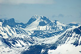
Galdhøpiggen seen from the east

Glittertind

Jotunheimen


Contenido relacionado
Ciudad Real Province
Pena Cabarga
Monanthochloe