
San Salvador


San Salvador is the capital and largest city of the Republic of El Salvador and one of the most populous cities in Central America. Located in one of the fourteen departments of the nation, specifically in the department of San Salvador, it houses the headquarters of the three powers of the State, the main companies in the economy, development, telecommunications, embassies, hotels, the Presidential House of El Salvador, the main museums in the country, residential, economic and commercial areas, monuments and the main headquarters of economic, political, fashion, art and development services in El Salvador.
San Salvador is the largest urban center in the country from an economic, demographic, social, cultural, historical, industrial, and political point of view. Considered the second most densely populated city and with the fastest economic development in the Central American region, after Guatemala City and excluding Panama City, it is an important city in the so-called "Northern Triangle of Central America" and one of the main settlements of national and international companies and financial and social services in the country.
The first foundation of San Salvador took place in 1525, probably in Antiguo Cuscatlán. It was refounded in 1528 to the south of Suchitoto, but its population would be settled in its current location until 1545. It was an important commercial center during the Spanish colonization due to indigo agriculture and became the seat of the Mayor's Office, Intendancy and the Province of the territory that, for the most part, today makes up El Salvador.
The first two uprisings of the isthmus against the authorities of the Spanish crown occurred in San Salvador around 1811. Later, it maintained its autonomy during the annexation to the First Mexican Empire, to which it was forcibly annexed for a brief time. After Guatemala City served as the capital of the Federal Republic of Central America, between 1824 and 1834, in addition to a brief period in which it was Sonsonate, San Salvador took over between 1834 and 1840, for which it created a Federal District that included San Salvador and various municipalities on the periphery.
Already with the development of coffee agriculture, the city had a notable development in its infrastructure since the end of the 19th century. However, because it is located in a highly seismic zone, it has been plagued by earthquakes throughout its history. Only photographs, portraits or plans remain of its old colonial buildings, such as its old cathedral and aqueduct. The 1873 earthquake, for example, caused San Salvador to be rebuilt with wooden or iron buildings imported entirely from Belgium and Italian die-cut sheet metal, such as the churches of San Francisco and Sagrado Corazón, as well as the Rosales Hospital, among others.
San Salvador is one of the first cities of Spanish foundation in historical Central America, the region that during the Hispanic colonization of America constituted the Kingdom or General Captaincy of Guatemala. It is also the oldest and most durable capital in the aforementioned region, since, since its transfer in 1545 to the Valley of the Hammocks, it has remained there from that year to the present. Also, because since the Spanish Monarchy designated it as the administrative seat of the province of San Salvador in 1540, it remained so until it was established as the capital of the Salvadoran State. Despite the earthquakes, floods and eruptions that this population had to endure for centuries, it was always rebuilt on its original site. Despite some attempts to relocate to less seismic areas, San Salvador has established itself as the main city of El Salvador.
The city is also the seat of the Archdiocese of San Salvador, as well as many Protestant branches of Christianity, including Evangelicals. The Central American Integration System (SICA) is headquartered in San Salvador. In the sports field, it has hosted the Central American and Caribbean Games in 1935 and 2002, and the Central American Sports Games in 1977 and 1994, and in 2023 it will host the 72nd edition of Miss Universe.
With a population of 621,123 inhabitants, this city is the main city of the San Salvador Metropolitan Area, a conurbation of around 2,232,139 inhabitants by the year 2021. It should be noted that, for this reason, this urban agglomeration It is the second largest in Central America, only surpassed by the AMG in Guatemala City, and the sixth in the entire Central American and Caribbean region.
Toponymy
In 1457, Pope Callistus III instituted the Catholic feast of the Holy Savior every August 6, in thanksgiving for the victory of Christian armies over the forces of Mehmed II in 1456 during the siege of Belgrade. In this way, many populations and places were designated with the name of San Salvador and several churches placed under the invocation of the Divine Savior of the World. It was thus that Christopher Columbus baptized the island of Guanahaní with such a name. For his part, Pedro de Alvarado, when organizing a second expedition on the territory of Cuscatlán, ordered his brother Gonzalo de Alvarado to give the name of San Salvador to the town that was founded there, something that probably happened on 1 April 1525.
History
Foundation of the city and colonial times
After the victories over the Pipil hosts in the battles of Acajutla and Tacuzcalco, the conquistador Pedro de Alvarado tried to subdue the natives of the capital of the Señorío de Cuzcatlán upon his arrival on June 18, 1524. The cuscatlecos, without However, they fled to the neighboring mountains and the people of Extremadura had to retreat to the area of present-day Guatemala. The first town of San Salvador was founded less than a year after this expedition, by an undocumented mission under the command of Gonzalo de Alvarado. The first mention of this settlement is in a letter from Pedro de Alvarado himself in Guatemala on May 6, 1525 noting that a town hall could not be held due to the absence of Diego de Holguín who had left to take the post of ordinary Mayor of the town of San Salvador.
Due to frequent rebellions on the site by the natives, a new village was established in the place now known as Ciudad Vieja, south of the current town of Suchitoto (April 1, 1528). Its original layout took fifteen days and it came to be populated by a number of 50 to 60 houses, having Antonio de Salazar and Juan de Aguilar as mayors.
After the pacification of the region, the small town was gradually abandoned and the new settlement was located, in the year 1545, in the Zalcoatitán valley, renamed “Valle de las Hamacas”. It is estimated that such encampment was on the so-called Cuesta del Palo Verde, and that it was known as "la Aldea". To the north of that location, the Plaza Mayor began to be traced, where the Plaza Libertad is currently located; to the East, the Church consecrated to the Most Holy Savior of the World was erected. On September 27, 1546, through procedures of the attorneys Alonso de Oliveros and Hernán Méndez de Sotomayor, and at the request of the Secretary of the Royal Crown Juan de Samano before the infant Don Felipe due to the absence of Emperor Carlos V of Germany and I of Spain, the town was elevated to the category of city by Royal Provision.
During the colonial era it was the most important city of the Mayor of San Salvador, in turn part of the Kingdom of Guatemala. In the 17th century, the main activity in this region was indigo, for export to Europe. In the second half of the 18th century, due to the Bourbon Reforms, which aimed to improve tax collection and create state monopolies, the Municipality of San Salvador was created in 1785; the city itself was the head of his party.
San Salvador is the enviable prece of the first impetuous start of freedom. —Manuel Valladares Rubio: José Matías Delgado. |
Republican era

San Salvador played an important role in the years before the independence of Central America. It was there that the first rebellion took place in 1811 against the authorities of the Captaincy, and one more in 1814, both unsuccessful, a movement led by the priest José Matias Delgado and Manuel José Arce Fagoaga who continued until independence from Spain in 1821. With the declaration of the Plan of Iguala by Agustín de Iturbide, the then provinces of the Captaincy declared their emancipation on September 15, 1821. News of this event reached San Salvador on September 21.
From then on the old municipalities were governed independently. In fact, in San Salvador a Political Chief governed. But, ultimately, they were all still under the direction of a Provisional Consultative Board based in Guatemala. Months later, an invitation from Iturbide arrived from Mexico for the provinces to join the new Empire. The Board decided its annexation on January 5, 1822; only two municipalities, of the 170 that made up the region, refused: San Salvador and San Vicente. In the following two years the city faced two invasions from Guatemala, which the defending forces were able to repel. However, in February 1823, Vicente Filísola besieged the city and occupied it; his stay ended due to Iturbide's withdrawal from power.
With the birth of the Federal Republic of Central America in 1824, the city was caught up in the turbulent years that pitted liberals and conservatives against each other. To separate itself from the influence of power exercised by Guatemala City, the Federal Congress decided to move the federation's capital to San Salvador in June 1834, and created a Federal District there on April 20, 1835. The chaotic situation of the region created a state of general poverty. Such a condition also caused a cholera epidemic in 1836.
The country's economy gradually changed in the second half of the 19th century, as indigo was replaced by the cultivation of coffee as the main export product. The city had a change in its main buildings, whose designs had European influences. For that matter, during the administration of General Gerardo Barrios, a National Palace with Neoclassical characteristics was built; the same as the University of El Salvador, in 1870, with notable French influences. On the other hand, an outstanding fact was the arrival of the telegraph in 1879. A traveler named Sherzer described the population in those years:
Among all the cities I have visited in Central America, with the only exception of Guatemala, (San Salvador) is the cleanest and most pleasurable appearance
An American diplomat, Ephraim George Squier, for his part, in a book called "Notes on Central America" estimated the population of this town at 25,000 people in 1852. Despite everything, any advance in the infrastructure had as a consequence problem the usual earthquakes that have devastated the region. For example, the earthquake of April 16, 1854 caused so much destruction in the capital that the authorities moved to Cojutepeque for four years; and Santa Tecla arose to make it a potential capital. But in 1858 the authorities returned to San Salvador and by Legislative Decree of January 27, 1859, published in the Gaceta del (Sic) Salvador No. 75, Volume No. 7, of February 1859, the old city of San Salvador was declared once again the capital of the country. There were other telluric events in 1873 and 1880.
20th and 21st centuries
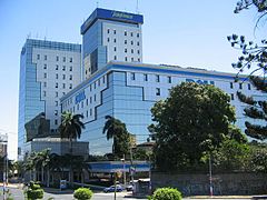
.jpg)


At the beginning of the 20th century, the capital, like the country in general, developed based on the income generated by the export of coffee. As an expression of that prosperity, various structures recognized in the city were started, such as the Dueñas Park, later known as Plaza Libertad (1900); the National Theater of San Salvador; the former Presidential House (1911) and the Rosales Hospital (inaugurated in 1902). All built for the sake of making the town more cosmopolitan. However, again natural disasters destroyed many buildings of those years with the earthquakes of 1917 and 1919; and a flood in 1922.
Because it is the seat of government, important political events took place in San Salvador throughout the century. Just in the early years, the assassination of Manuel Enrique Araujo took place on February 4, 1913 in Parque Bolívar, now Plaza Gerardo Barrios. Years later, Maximiliano Hernández Martínez would come to power through a coup in 1931, in the midst of the economic crisis that resulted in the fall in coffee prices during the years of the Great Depression. From then on, a time of political turmoil would begin with the predominance of the military establishment. In the 1970s,

With the increase in political violence, San Salvador was the scene of numerous popular protests by various organizations opposed to the regime; the largest of them, recorded in the country's history, occurred on January 22, 1980.
With the advent of the civil war, despite not being the theater of military operations, the situation in the streets of the capital was uneasy. Forced disappearances, bombs and public transport stoppages were common. In those years, one event in particular devastated the metropolitan area: the 1986 earthquake, which, in addition to claiming around 5,600 lives, destroyed many of the buildings of the "Centro Histórico". Another of the most critical moments occurred with the so-called "final offensive" on November 11, 1989. The signing of the Chapultepec Peace Accords on January 16, 1992, ended the civil war. In those days, various displays of joy took place in the historic center, especially on February 1 with the official cessation of military actions. Despite this historic achievement that put an end to political violence, new challenges appeared with the progression of criminal violence.

In the 1990s there was an economic boom with the implementation of a neoliberal model in the country. The city was more economically active with the arrival of international franchises, the creation of new vehicular overpasses, new shopping centers, and recreational areas. In the first decade of the 21st century, the Government has built new roads on the outskirts of the municipality to relieve traffic congestion through the city. On the other hand, unemployment in recent years has caused more social problems, including the increase in informal trade.
Geography
San Salvador is located in the central zone of the country. Its elevation is between 600 and 1000 meters above sea level. Although the city itself is located at 670 m s. no. m. It limits to the north with the municipalities of Nejapa, Mejicanos, Cuscatancingo, and Ciudad Delgado, to the east with Soyapango and San Marcos, to the south with Panchimalco and also with San Marcos, and to the west with Antiguo Cuscatlán and Santa Key.
The geography of the Salvadoran capital is dominated by two large orographic prominences, which make the landscape of the capital unmistakable, since they can be observed from any point of the city: the San Salvador Volcano and the San Jacinto Hill. The first is made up of two large formations: El Picacho, with a height of 1959.97 ms. no. m.; and the other, El Boquerón, the most voluptuous formation, 1839.39 m s. no. m., which has a huge crater 1.5 km in diameter. This volcano is representative of the city, to the point that it basically forms its skyline (horizon), paling any other structure built by human hands in the city, perhaps that is why despite a certain real estate takeoff that the town has experienced since the late 1990s, no structure has become its icon, except for the historic buildings. The second most representative orographic structure of this municipality is Cerro San Jacinto, which has a height of 1100 meters above sea level and which until recently had a cable car on its top. The aforementioned San Salvador Volcano is located to the west of the city, while Cerro San Jacinto is at its southeast end. These two natural watchtowers frame the valley in which San Salvador sits.
The valley in which San Salvador is located is called "de Las Hamacas" or "Zalcoatitán". The first was laid by the Iberian conquerors due to its seismic nature. And it is that this valley is crossed by many tectonic faults, which is why San Salvador has been destroyed and rebuilt more than twenty times since it moved to this territory in 1545. The valley is very narrow compared to other Salvadoran valleys and It is far from flat, since from the West, where the San Salvador Volcano is located, it reaches a height of more than 1000 m s. no. m. to then gradually descend until it meets Cerro San Jacinto and the banks of the Acelhuate River, reaching here a low altitude of 590 m s. no. m., resulting in the sight of any spectator that this valley is only a long extension of the slopes of the San Salvador Volcano. Besides this, the valley is not always continuous, since it is crossed by many sandbanks and rivers, such as Arenal La Mascota, Arenal Monserrat, Arenal Tutunichapa, among others, all running from West to East, following the depression from the plain until it flows into the Acelhuate River.
To the south, the valley and municipality of San Salvador is flanked by the Cordillera del Bálsamo, separating it from the coastal plain. To the north, the passage of the Las Hamacas Valley is blocked by some gentle mountain ranges corresponding to the municipalities of Ayutuxtepeque and Ciudad Delgado, which separate San Salvador from another long valley that extends to the Lempa River basin in the north of the country..
| Northwest: Santa Tecla (Department of Freedom) and Nejapa | North: Mexicans and Cuscatancingo | Northeast: Delgado City |
| West: Former Cuscatlán (Department of Freedom) |  | This: Soyapango |
| Southwest: Ancient Cuscatlán (Department of Freedom) | South: Panchimalco and San Marcos | Sureste: San Marcos |

Climate
San Salvador has a warm climate all year round, with December, January and February being the coolest. Temperatures remain between 18 and 33 degrees Celsius. The hottest are from March to May. From May to October is the rainy season, floods usually occur (especially in the rivers).
The temperature fluctuates between noon and midnight, due to changes in humidity levels. The highest temperature recorded in San Salvador was 38.5 °C, the lowest was 4.0 °C.
| Month | Ene. | Feb. | Mar. | Open up. | May. | Jun. | Jul. | Ago. | Sep. | Oct. | Nov. | Dec. | Annual |
|---|---|---|---|---|---|---|---|---|---|---|---|---|---|
| Temp. max. abs. (°C) | 38.3 | 39.4 | 40.6 | 40.0 | 39.4 | 36.7 | 36.7 | 36.7 | 37.2 | 38.3 | 38.9 | 38.3 | 40.6 |
| Average temperature (°C) | 30.3 | 30.1 | 32.0 | 32.2 | 30.8 | 29.5 | 30.1 | 30.0 | 29.0 | 29.1 | 28.0 | 28.6 | 30 |
| Average temperature (°C) | 22.2 | 22.8 | 23.8 | 24.5 | 24.2 | 23.3 | 23.3 | 23.2 | 22.8 | 22.8 | 22.4 | 22.0 | 23.1 |
| Temp. medium (°C) | 15.9 | 16.8 | 17.7 | 19.0 | 20.0 | 19.6 | 19.1 | 19.3 | 19.4 | 18.0 | 17.9 | 15.1 | 18.2 |
| Temp. min. abs. (°C) | 7.2 | 9.4 | 7.2 | 12.2 | 14.4 | 13.3 | 14.4 | 15.6 | 11.7 | 12.2 | 9.4 | 8.3 | 7.2 |
| Total precipitation (mm) | 5.0 | 2.0 | 9.0 | 36.0 | 152.0 | 292.0 | 316.0 | 311.0 | 348.0 | 217.0 | 36.0 | 10.0 | 1734.0 |
| Precipitation days (≥ 1 mm) | 1 | 1 | 1 | 5 | 13 | 20 | 20 | 20 | 20 | 16 | 4 | 2 | 123 |
| Hours of sun | 301 | 277 | 294 | 243 | 220 | 174 | 239 | 257 | 180 | 211 | 267 | 294 | 2957 |
| Source No. 1: World Meteorological Organization, Global Bioclimatic Classification System (extreme) | |||||||||||||
| Source No. 2: Danish Meteorological Institute (sun only) | |||||||||||||
Orography
Among the elevations that the municipality has are Cerro El Picacho, Cerro San Jacinto and Cerro Chantecuán, and there are also the hills of La Torre and Candelaria. In the area there are types of soils such as regosols, latosols and andosols, and rocks such as andesitic lava and basaltic lava.

Hydrography
The main rivers of the municipality are the Acelhuate river, which is 2.2 km from the city, and the Iohuapa river, 5.2 km away. There are also the Matalapa, El Garroba, San Antonio, Urbina and Casa de Piedra rivers. ravines are El Garrobo, Sirimullo, La Quebradona, Los Cojos, Las Lajas, El Manguito, La Lechuza, La Mascota, San Felipe, Tutunichapa and Mejicanos.
Municipal government
In El Salvador, by constitutional provisions, municipalities are autonomous in economic, technical and administrative matters (Art. 203). They are governed by a council made up of a mayor (elected by free and direct vote every three years, with the option of being re-elected), a trustee and two or more aldermen whose number varies in proportion to the population of the municipality. In the case of this city, it is currently governed by Mayor Mario Durán, who is part of the Nuevas Ideas party, and was elected for the period 2021-2024 under the banner of this political party. He is accompanied by a trustee, eight proprietary councilors and four substitutes; and a secretary. The functions and powers of this government are framed within the regulations of the Municipal Code.
Regarding the administration of the municipality, it is worth noting some organizational aspects. San Salvador has decentralized entities (festival committee, administration of the El Espino farm, Parque Cuscatlán, administration of cemeteries, etc.); to safeguard the interests of the commune, it has a Body of Metropolitan Agents; The structure includes Market and Citizen Services Management, under the direction of a Gender Unit; Management of districts of the commune (which are six, to decentralize municipal work), Finance Management, and a Management of the historic center, etc. The commune, in addition, is part of the Council of Mayors of the Metropolitan Area of San Salvador (COAMSS), made up of fourteen municipal councils that make up the area called Greater San Salvador.
Mayors of San Salvador since 1964
Since 1964, the following people were mayors of San Salvador:

| Name | Period | Party |
|---|---|---|
| José Napoleón Duarte | 1964-1970 | PDC |
| Carlos Herrera Rebollo | 1970-1974 | PDC |
| José Antonio Morales | 1974-1976 | PDC |
| José Napoleón Gómez | 1976-1978 | PCN |
| Hugo Guerra and Guerra | 1978-1979 | PCN |
| Julio Adolfo Rey Prendes | 1979-1981 | PDC |
| José Alejandro Duarte Durán | 1982-1985 | PDC |
| José Antonio Morales | 1985-1988 | PDC |
| Armando Calderón Sol | 1988-1994 | ARENA |
| Mario Valiente | 1994-1997 | ARENA |
| Héctor Silva | 1997-2003 | FMLN |
| Carlos Rivas Zamora | 2003-2006 | FMLN |
| Violeta Menjívar | 2006-2009 | FMLN |
| Norman Quijano | 2009-2015 | ARENA |
| Nayib Bukele | 2015-2018 | FMLN |
| Ernesto Muyshondt | 2018-2021 | ARENA |
| Mario Durán | 2021-2024 | NI |
Symbols of the city
From May 5, 2015 to May 1, 2018, the city of San Salvador held another coat of arms. The banner was revealed by the mayor Nayib Bukele who detailed the meaning of the elements, among which the shield with three diagonal stripes (two blue and white in the center) stands out, surrounded by a laurel wreath. Under it is a ribbon with the year "1834" which corresponds to the date on which San Salvador was the capital of the Federal Republic of Central America. There are also two swords that converge in the coat of arms that symbolize belonging to Francisco Morazán and Gerardo Barrios, which also penetrate two scrolls with the words "City" and "Capital" respectively. The entire emblem is surrounded by six stars that represent the six districts of San Salvador.
On May 1, 2018, Ernesto Muyshondt took the building staff and restored the previous coat of arms created by José Mejía Vides. In 2021, the new mayor Mario Durán restored the shield that the former mayor Nayib Bukele made in 2018 and that Ernesto Muyshondt withdrew after his entry into the mayor's office, the former mayor Ernesto Muyshondt was accused of the crime of misappropriation of tax withholdings to the detriment of the Public Treasury and is currently in prison.
There is also the anthem and the building staff, which were adopted —along with the old coat of arms— from a contest promoted in 1943. The flag was designed at the initiative of the authorities. The hymn prepared by Carlos Bustamante (lyrics) and Ciriaco de Jesús Alas (music) was chosen. The municipal rod, for its part, shows a series of figures and symbols related to local history.
Results of municipal elections in San Salvador
2021
| Candidate | Party | Votes | Percentage | ||
|---|---|---|---|---|---|
| Mario Durán | 100.768 |
| |||
| Ernesto Muyshondt | 64,109 |
| |||
| Héctor Silva | 7,441 |
| |||
| Rogelio Canales | 5,773 |
| |||
| Miriam Handal | 834 |
| |||
| Linda Villalta | 653 |
| |||
| Valid votes | 179,578 | - | |||
| Not valid ballots | 1.716 | - | |||
| Total votes (participation) | 181,294 |
| |||
2018
| Candidate | Party | Votes | Percentage | ||
|---|---|---|---|---|---|
| Ernesto Muyshondt | 88,194 |
| |||
| Jackeline Rivera | 39.736 |
| |||
| Yesenia Hernández | 5.257 |
| |||
| Rafael Menjívar | 3,310 |
| |||
| Antonio Murillo | 3,210 |
| |||
| Yessenia López | 2,488 |
| |||
| Joshua Peralta | 1,698 |
| |||
| Valid votes | 143,893 | - | |||
| Not valid ballots | 15,833 | - | |||
| Total votes (participation) | 159.726 |
| |||
2015
| Candidate | Party | Votes | Percentage | ||
|---|---|---|---|---|---|
| Nayib Bukele | 89.164 |
| |||
| Edwin Zamora | 83,396 |
| |||
| Walter Araujo | 1.389 |
| |||
| Roberto Cañas | 1,303 |
| |||
| Adolfo Salume | 1.019 |
| |||
| Luis Cuenca | 736 |
| |||
| Valid votes | 177,007 | - | |||
| Not valid ballots | 1.768 | - | |||
| Total votes (participation) | 178,775 |
| |||
2012
| Candidate | Party | Votes | Percentage | ||
|---|---|---|---|---|---|
| Norman Quijano | 109,470 |
| |||
| Jorge Schafik Handal | 56,882 |
| |||
| Silvia Aguilar | 2,821 |
| |||
| Andrés Espinoza | 1,366 |
| |||
| Marvin Prado | 1,194 |
| |||
| Leonardo Cuéllar | 462 |
| |||
| Vicente Ramírez | 370 |
| |||
| Valid votes | 172,679 | - | |||
| Not valid ballots | 1,802 | - | |||
| Total votes (participation) | 174,481 |
| |||
2009
| Candidate | Party | Votes | Percentage | ||
|---|---|---|---|---|---|
| Norman Quijano | 86.569 |
| |||
| Violeta Menjívar | 80.789 |
| |||
| Gloria Ayala | 2.589 |
| |||
| Celina Monterrosa | 2,100 |
| |||
| Carlos González | 1,698 |
| |||
| Valid votes | 173.745 | - | |||
| Not valid ballots | 1.096 | - | |||
| Total votes (participation) | 174,841 |
| |||
2006
| Candidate | Party | Votes | Percentage | ||
|---|---|---|---|---|---|
| Violeta Menjívar | 64.888 |
| |||
| Rodrigo Samayoa | 64.844 |
| |||
| 9,651 |
| ||||
| 3,007 |
| ||||
| 1,878 |
| ||||
| Valid votes | 144.268 | - | |||
| Not valid ballots | 1,484 | - | |||
| Total votes (participation) | 145,752 |
| |||
2003
| Candidate | Party | Votes | Percentage | ||
|---|---|---|---|---|---|
| Carlos Rivas Zamora | 59.310 |
| |||
| Evelyn Jacir de Lovo | 49,993 |
| |||
| María Pérez | 5.780 |
| |||
| Maria Castillo | 2,057 |
| |||
| Alejandro Mixco | FC | 1.780 |
| ||
| Ana María Hasbún | 735 |
| |||
| Valid votes | 119.655 | - | |||
| Not valid ballots | 1.934 | - | |||
| Total votes (participation) | 121.589 |
| |||
2000
| Candidate | Party | Votes | Percentage | ||
|---|---|---|---|---|---|
| Héctor Silva | 68.660 |
| |||
| Luis Cardenal | 47.575 |
| |||
| Ricardo Martínez | 2.525 |
| |||
| Marta Castro | 1.619 |
| |||
| Rafael Montalvo | PANEL | 1,544 |
| ||
| Valid votes | 121.923 | - | |||
| Not valid ballots | 1,506 | - | |||
| Total votes (participation) | 123.429 |
| |||
1997
| Candidate | Party | Votes | Percentage | ||
|---|---|---|---|---|---|
| Héctor Silva | 56,565 |
| |||
| Mario Valiente | 49.171 |
| |||
| 3.188 |
| ||||
| Eddie González | 3,251 |
| |||
| Valid votes | 120.839 | - | |||
| Not valid ballots | 2,189 | - | |||
| Total votes (participation) | 123,028 |
| |||
1994
| Candidate | Party | Votes | Percentage | ||
|---|---|---|---|---|---|
| Mario Valiente | 77,901 |
| |||
| 46,651 |
| ||||
| 21,493 |
| ||||
| 13,136 |
| ||||
| Valid votes | 160,793 | - | |||
| Not valid ballots | 4,902 | - | |||
| Total votes (participation) | 165.695 |
| |||
Demographics
San Salvador is the most populous city in the country with an estimated 281,870 inhabitants for the year 2014, and 1,740,053 inhabitants in Greater San Salvador or AMSS (San Salvador Metropolitan Area, 2012 estimate). Downtown San Salvador is located at an elevation of 658 ms. no. m. and its population density is 2,067 inhabitants per km².
Religion


In the center of the city is the Metropolitan Cathedral of the Divine Savior of the World, which is part of the Archdiocese of San Salvador. The patron saint festivities are in honor of the Divine Savior of the World, patron saint of the city since colonial times. Likewise, the Virgin of the Presentation, which may have been the first to whom the ancient settlers worshiped, is considered "Patron Protector of the City of San Salvador". The Virgin of the Rosary is also patron saint of the Archdiocese and the metropolis.
Most of the population professes Catholicism, but there is also a considerable number of evangelical and Protestant groups such as the Asociación Bautista de El Salvador (ABES) and the Federación Bautista de El Salvador that has small local churches throughout the territory national, the Assemblies of God, the Church of God, the Elim Church, the Tabernacle Bible Baptist "Friends of Israel", the Central American Mission and Tabernacle of International Revival (TAI). There are also Jewish religious communities, not to mention Jehovah's Witnesses, The Church of Jesus Christ of Latter-day Saints, and Seventh-day Adventists.
| Catholics | 43.9% |
| Protestants and Evangelicals | 36.5% |
| None | 13.2% |
| Other | 4.2% |
| Agnostic or atheist | 2.2% |
San Salvador's population is predominantly Catholic, with a significant minority of Protestants. There is more diversity of religion than in most Latin American countries. The Protestant population is mostly Evangelical. One of the largest Protestant churches in the city is the Joshua Christian Church (of the Assemblies of God), another is the Tabernáculo Bíblico Bautista, Amigos de Israel (Biblical Baptist Tabernacle, Friends of Israel). There is also a sizable population of members of The Church of Jesus Christ of Latter-day Saints often nicknamed Mormons. The Mormon community in El Salvador recently built its first temple in El Salvador, a structure of impressive engineering and architecture. There are also smaller Latter-day Saint chapels in Districts 1 and 3.
As in most of the country, Catholicism still plays an important role in celebrating holidays, such as Las Fiestas Agostinas (The August Festivals) in honor of Jesus Christ, the "saint" patron saint of El Salvador, known as El Salvador del Mundo (The Savior of the World). These events are becoming less prominent with a marked decline in the Catholic population over the last decade. San Salvador is also home to some 3,500 Jews; the Jewish community is still strong, but not so strong since the 1980s, as many of them left with the start of the Salvadoran Civil War. Many Jews had immigrated to El Salvador during World War II due to the work of José Castellanos Contreras the Salvadoran diplomatic consul general in Geneva, Switzerland, who helped a Hungarian-Jewish businessman named Gyorgy Mandl (later he adopted the name George Mantello). to save 40,000 Jews in Central Europe from Nazi persecution by giving them Salvadoran nationality papers. The city has a small community of Palestinians mostly descendants of Palestinian Christian families who immigrated from Palestine in the late 19th century and early 20th century, with the highest rate of immigration between 1910 and 1925. The city also has Korean Evangelical churches that maintain services in the Korean language for a growing Korean population.
Economy


Industry and commerce
The city, being the capital, has numerous places for the production of food, beverages, and handicrafts. Also construction materials, pharmaceutical and chemical industries, as well as automotive mechanics, and household appliances. Examples are MOLSA (Mills of El Salvador) and Industrias La Constancia
It is also home to important shopping centers that, in addition to offering products to visitors, are a source of employment for many Salvadoran families; among which are mentioned the Metrocentro shopping center, "El Paseo" and Galerías Shopping Center, Plaza San Luis, Plaza Presidente, Bambu Plaza, Plaza Basilea, Plaza Futura.
There are also prestigious business centers such as the Centro Financiero Gigante and the World Trade Center San Salvador, where important companies and international organizations are housed such as: Microsoft, Ericsson, IDB, Mitsubishi Corporation, IntelAMCHAM, Embassy of Japan, Banco Agrícola, Organization of American States (OAS), World Bank, Korean Embassy, Japan Cooperation Agency (JICA) and the Korean Cooperation Agency (KOICA) and the British Embassy.
On the other hand, regarding the accommodation service, San Salvador has both luxury and tourist class hotels. Among the most important:
- Hotel Real InterContinental San Salvador
- Hotel Barceló San Salvador
- Sheraton President San Salvador
- Crowne Plaza San Salvador along with Plaza Hotel & Suites.
As for the municipal markets, the Central Market stands out, the largest in the city with ten pavilions; Others are: San Jacinto, Belloso, La Tiendona, Sagrado Corazón, Modelo, San Miguelito, Hula Hula, San Antonio, Tinneti, and Cuscatlán, the latter which integrates both the commercial sector and the cultural activity.
Culture and society
Heritage and monuments

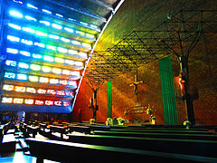
In San Salvador there are various monuments and places of historical interest, many of which are part of the declared cultural heritage of this nation. The Monument to the Divine Savior of the World stands out, located in Plaza Salvador del Mundo, dedicated to the Patron of the city and a national symbol. Considered national monuments are: the bell tower of the Church of La Merced; mausoleum of the writer Alberto Masferrer; Captain General Gerardo Barrios; from General Francisco Morazan, the Church of Our Lady of Candelaria; the National Theater of San Salvador, the National Palace; and the Rosales Hospital, among others; as cultural assets: the House of the Academies; former Presidential House; Venustiano Carranza Park; Blue Room of the National Palace, etc.; Also among the historical places, the El Rosario Church stands out, built on the old seat of the city's Cathedral.

Some of these sites are located within the so-called Historic Center of San Salvador, where the growth of the city began since colonial times. This area has been destroyed over time by natural disasters and the buildings that remain are from the late XIX and early centuries. of the XX; For that matter, there are Plaza Francisco Morazán, Plaza Barrios and Plaza Libertad with the Monument to the Próceres. To the west of the capital is the Monument to the Revolution, erected in the middle of the XX century. An interesting complex is the Cementerio de Los Ilustres, in the General Cemetery of San Salvador, which boasts various mausoleums and artistic statues, since the remains of members of wealthy families and Salvadoran personalities rest there, including politicians such as Francisco Morazán and Gerardo Barrios, or writers like Salarrué and Claudia Lars. On the other hand, in memory of the victims of the Salvadoran Civil War, is the Monument to Memory and Truth in Cuscatlán Park.
Cultural activities and entertainment


To enjoy the nightlife in this capital there is a wide range of restaurants, discos and bars. For that matter, there are identified areas that concentrate these recreation centers: the Zona Rosa, to the west, on the Hipódromo boulevard; the Zona Real, located around Los Héroes boulevard; and the Paseo General Escalón. It should be noted that some of these contours are included within the areas where it is not allowed to carry weapons according to a law of the republic. Massive musical shows are held in large sports venues such as the National Gymnasium, the Cuscatlán Stadium, and until 2019 in the amphitheater of the International Center for Fairs and Conventions, today Hospital El Salvador. Another option is the second tallest structure in the country: the Torre Futura, which houses offices and a commercial area.
In San Salvador there are theater seasons. The best place for performing arts presentation is the National Theatre. Other establishments include: the Luis Poma Theater, the Roque Dalton Municipal Theater, the Presidente Theater, headquarters of the El Salvador Symphony Orchestra, and auditoriums of institutions such as the Dr. José Matías Delgado University, the Central American University "José Simeón Cañas"; or the Cultural Center of Spain. There are also exhibitions by the National and Youth Symphony Orchestra. For the exhibition of plastic arts there are places like the National Exhibition Hall "Salarrué" located in Cuscatlán Park, and others of a private nature such as the Forma Museum and the Art Museum (MARTE). As for movie theaters, the offer is found in large shopping centers. An important space for the development of art and culture is the Legislative Cultural Civic Center.
Regarding places for family recreation, the city has Cuscatlán Park, the National Zoo (permanently closed in 2022), Saburo Hirao Park, El Talapo Metropolitan Park, and the Bicentennial Park and the Children's Amusement Park.
At the beginning of August the patron saint festivities dedicated to the Divine Savior of the World are celebrated. On this occasion the main events are the postal parade, the parade of floats that cross the city, the fairground, as well as a religious procession on August 5, which culminates in a ceremony representing the Transfiguration of Jesus; and a main mass, on August 6, in front of the Metropolitan Cathedral.
On the other hand, the XIV Assembly of the Union of Ibero-American Capital Cities elected San Salvador as the Ibero-American Capital of Culture for the year 2011, in view of the celebration of the Bicentennial of the First Cry of Independence of Central America.
Shopping Centers
During the last decades, San Salvador and its western surroundings (Santa Tecla and Antiguo Cuscatlán), have had a commercial increase due to this, shopping centers have been built, in addition to the fact that San Salvador is the most important economic center of El Salvador and one of the most important in Central America
The main shopping centers in the Metropolitan Area of San San Salvador are:
- Metrocentro San Salvador, located in Los Heroes Boulevard in San Salvador
- Centro Comercial Galerías, located on the Paseo General Escalón in San Salvador
- Multiplaza Panamericana, located on the Panamericana and Calle Chiltiupan road in the municipality ofAntiguo Cuscatlán.
- La Gran Vía, located on the Panamericana and Calle Chiltiupan municipality of Antiguo Cuscatlán.
- Las Cascadas Shopping Center, located on the Panamericana and Chiltiupan Street in Ancient Cuscatlán.
- Plaza Merliot, located in the municipality of Santa Tecla.
- La Skina, located in the municipality of Santa Tecla
- Centro Comercial Santa Rosa, Located in Calle Real, municipality of Santa Tecla.
- Estación del Casco, Ubicada en la avenida espino en San Salvador
Museums and Libraries

To the west of San Salvador are located two important institutions for activities related to the culture of El Salvador. The first of these is the Dr. David J. Guzmán National Museum of Anthropology (MUNA), an institution dedicated to the study and preservation of the identity of this country through various investigations, permanent and traveling exhibitions related to archeology and anthropology. The other is the Museo de Arte de El Salvador (MARTE) which was inaugurated in 2003 as a private non-profit institution that exhibits national and private art collections, in addition to carrying out other educational programs and activities such as concerts, book fairs. Other sites in the capital include: for children, the Tin Marín Museum, next to Parque Cuscatlán; to the south are the Military History Center which includes: the Military History Museum, the National Sovereignty Memorial Square, the Scaled Relief Map of El Salvador, among others, it occupies the former facilities of the El Zapote barracks, Always to the South we find the Natural History Museum inside the Saburo Hirao Park. The city also has the Museum of the Word and the Image, Museum of Popular Art for the exhibition of handicrafts from Ilobasco, the University Museum of Anthropology owned by the Technological University of El Salvador, Museum of the Mortgage Bank of El Salvador and Museum of Ferrocarril, the Martyrs Memorial Room dedicated to the memory of the six Jesuit priests murdered by the FAES together with two collaborators (mother and daughter) during the offensive "Hasta El Tope" in the year 1989.
As far as libraries are concerned, the Francisco Gavidia National Library stands out, (currently under construction thanks to the financial support of the People's Republic of China) the General Archive of the Nation (located in the National Palace of El Salvador) the Library of the Legislative Assembly and the General Library of the Armed Forces. There are also other important libraries within educational institutions such as the Central American University "José Simeón Cañas", the Technological University of El Salvador, the University of El Salvador, etc.
Education
According to the database of the Ministry of Education, 316 educational centers operate in the municipality, of which 125 are public and 191 are private.
As for higher education institutions, some of the most important universities in the country have their headquarters, including:
- Universidad de El Salvador (Estatal).
- Universidad Tecnológica de El Salvador.
- Universidad Salvadoreña Alberto Masferrer.
- Universidad Pedagógica de El Salvador.
- Universidad Luterana Salvadoreña.
- Francisco Gavidia University.
- Open Modular University.
- Universidad Politécnica de El Salvador.
- Dr. University. Andrés Bello.
- Universidad Nueva San Salvador.
Sports

The city is home to important venues for practicing sports at a national and international level. Chief among these is the privately owned Cuscatlán Stadium, the largest in Central America. It is the headquarters of the National Soccer Team and the Alianza F.C. and C.D. Atlético Marte of the first division. Others are of public administration, under the direction of the National Sports Institute of El Salvador (an organization based in this city), such as the Jorge "Mágico" González (previously called "Flor Blanca"), which has, in addition to a soccer field, an athletics track and facilities for other sports.
The University of El Salvador also has the University Stadium, headquarters of C.D. El Salvador University. Likewise, you will find the Palacio de los Deportes "Carlos El Famoso Hernández", the scene of multiple indoor disciplines, as is the National Gymnasium "Adolfo Pineda" and the Complex for Water Sports and National Velodrome-Skating Track. (popularly called "el Polvorín").
Other facilities include the “Saturnino Bengoa” National Ball Park for playing baseball; and for softball, the "José Arnoldo Guzmán" field. The International Center for Fairs and Conventions of El Salvador is another alternative to host disciplines indoors.
The Olympic Committee of El Salvador is headquartered in San Salvador, and under its direction the most important international events have been held, being the III and XIX Central American and Caribbean Games in 1935 and 2002, respectively.
| Predecessor: | Central American and Caribbean City 1935 | Successor: |
| Predecessor: | Central American and Caribbean City 2002 | Successor: |
| Predecessor: | Central American and Caribbean City 2023 | Successor: |
Transportation and telecommunications

In the Metropolitan Area of San Salvador, around 200,000 registered vehicles circulate daily. Around 300,000 trips are made to the municipality of San Salvador itself, during peak morning hours. Around the city there are primary roads that connect it with the interior of the country, these being the Troncal del Norte highway, which leads to the municipality of Apopa and reaches the municipality of Citala in the department of Chalatenango, the highway to Santa Tecla towards the west of the country, the highway to the International Airport of El Salvador and the boulevard of the National Army, which leads to the East. Since the city is an obligatory passage if you cross the territory, the government has built, since the beginning of the century, various roads to decongest vehicular traffic. Among these highways are the Troncal del Norte to Soyapango route, extension of Constitución boulevard, and Monseñor Romero boulevard to the west of the capital.
Another important work culminated in February 2017 with the construction of the "Masferrer Tunnel", also to the west of the city, which allows smooth vehicle traffic between Jerusalem avenue and Masferrer Norte avenue below the Alberto Masferrer roundabout. This work incorporates two "inclusive walkways" that serve as a passage for pedestrians and cyclists, and that also has elevators and metal stands for people with disabilities.
The numerical denomination of streets and avenues is organized according to the four squares that form the intersection of España avenue and Cuscatlán avenue (to the north and south, respectively), with Arce and Delgado streets (to the west and east) In the city center. Thus, the avenues with odd numbers North and South are to the west of this intersection and those with even numbers to the East. The streets, for their part, with odd denominations west and east, are to the north of the intersection; the west and east pairs, to the south. Among the main streets and avenues of the city are the Paseo General Escalón, the Manuel Enrique Araujo avenue-Alameda Franklin D. Roosevelt-Rubén Darío street, the Juan Pablo II avenue, Los Héroes boulevard, Venezuela boulevard, Los Próceres boulevard, Constitution Boulevard, etc.
Regarding public transportation, there is considerable availability of buses and minibuses at a cost of US$0.20 and US$0.35 for the former and US$0.25 for the latter. In San Salvador there are also the Occidente and Oriente Terminals, which are the point of the bus units that go to various areas of the country, as well as international land transport companies that provide services to the other countries of Central America and the South. from Mexico.
SITRAMSS

San Salvador is part of the route of the Integrated Transport System of the Metropolitan Area of San Salvador (Sitramss). This work consists of the construction of exclusive corridors for BRT articulated buses that will transport passengers from San Martín to Santa Tecla. It came into operation in December 2013, partially. The system has a prepaid card, and its benefits are security, speed and the contribution to a cleaner environment.
Currently due to the COVID-19 pandemic, the service is suspended, however the Ministry of Public Works and Transportation, has reiterated throughout the presidential term of Nayib Bukele, the need for a new collective transportation for the metropolitan area of San Salvador, for which the MOP Minister, Romeo Rodríguez, has mentioned on several occasions that they are carrying out studies and feasibility plans for this new Transportation.
In September 2022, after the pandemic, the SITRAMSS service was declared out of operation and currently the stations that provided the service are abandoned.
Air Transportation
The main airports that serve the city of San Salvador are the El Salvador International Airport and the Ilopango International Airport. The El Salvador International Airport is located 30 minutes from the capital and from there 31 people are served direct destinations to North America, Central America, South America, Europe and the Caribbean. The International Airport of Ilopango is enabled only to serve civil flights, air taxis and TAG (Transporte Aéreo de Guatemala) offers regular services to Guatemala City and San Pedro Sula. In 2022 the government of El Salvador has announced the construction project of the International Airport in the eastern part of the country.
Media

The city has a variety of modern means of communication. In fixed, public and mobile telephony, the main companies dedicated to these services in the country have their headquarters in the city. Among them are Claro, Telefónica, Tigo, Digicel, etc. There is also coverage in cable, satellite, digital and Internet television services.
The main written media circulate in this capital and some of the country's main newspapers are based, including El Diario de Hoy, Diario El Mundo. As for television, companies such as Telecorporación Salvadoreña, Grupo Megavisión, and Tecnovisión also have their seat; There are also broadcasters from educational institutions (Francisco Gavidia University) and Christian (Catholic and Protestant) institutions. As for radio stations, there is a diversity of programming on the FM and AM frequencies, both with commercial, participatory-community or Christian content (Catholic or Protestant in line).
Social problems
In El Salvador, with the increase in violence, the Metropolitan Area is considered to have the highest crime rates in the country, thus being considered one of the most dangerous countries in Central America. Another very significant problem is the gangs, so much so that FBI offices have been opened in the city. A problem that has been in force is the disorder in the historic center, by street vendors, a problem that is originated by the growth of the national population, and the search for daily sustenance, something that has given rise to the disorder in the center of the capital.
Gallery
- San Salvador, El Salvador

Plaza Salvador del Mundo

Palacio Nacional de El Salvador

Metropolitan Cathedral of San Salvador

Monument to the Constitution

Monument to the Proceres
Church of the Rosary
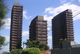
Torres 105 Campestre

Church The Calvary

San Salvador at night

Monument of the Revolution

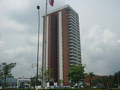
Torre Roble
Torre Futura
Torre El Pedregal
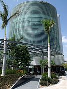
Giant Financial Centre

Bulevar Monseñor Romero


.JPG)


International relations
Twinnings that the Mayor of San Salvador has carried out with other cities and political entities:
Twinnings
They have 14 sisterly capitals with:
|
|
They have 10 sister cities with:
|
|
|
Other political entities
 California State Senate, United States.
| Predecessor: |  Ibero-American Capital of Culture 2011 | Successor: |
Contenido relacionado
Magallanes and Chilean Antarctic Region
Rancagua
Lisbon