
San Fernando de Henares
San Fernando de Henares, traditionally and historically known as "Royal Site" de San Fernando, is a municipality located to the east of the Community of Madrid, about 15 kilometers east of the capital. It is located in the Corredor del Henares and is part of the metropolitan area of Madrid. Part of its term is included within the Regional Park of the Southeast. It has an area of 39.29 km² and a population of 38,904 inhabitants.
Toponymy

The name San Fernando is used in honor of the patron saint of the founder of the Royal Site Fernando VI of Spain, whose name day corresponds to that of another medieval king Ferdinand III of Castile, called the Saint; and the complement of Henares comes from the Henares river, although the river most closely linked to the historical development of the municipality has been the Jarama river, which borders the urban area to the east, not in vain, the municipality is called "San Fernando de Jarama" until in 1916, the full town council, without apparent justification, decided to change the fluvial surname to that of the Henares river.
There is currently a debate about whether the municipality should be renamed "Real Sitio de San Fernando de Jarama", in coherence with its historical evolution and linkage of the town with the Jarama river, although, its cost and disturbance for the neighbours, advises against it for practical reasons.
Symbols

The heraldic shield that represents the municipality was officially approved on June 2, 1977 with the following coat of arms:
«From siple, a palace of gold, made of sable and cleared of gules, surmounted with a royal crown closed and at the tip the F. VI anagram (Fernando VI) of gold. »Official State Gazette No. 160 of 6 July 1977
Between 1868 and 1977, the city council used the seal inherited from the Royal Administration of the former Royal Site of San Fernando until the constitution of the city council and the municipality in that year as the emblem of the institution and the municipality's coat of arms. Said emblem consisted of two linked laurel branches, with the FVI (Ferdinand VI) anagram between them, all mounted by a closed royal crown. Currently this symbol is officially suppressed by the City Council.
The textual description of the flag, approved on June 5, 1997, is as follows:
"Proportions 2:3. Red cloth, crossed diagonally from the top angle of the asta to the bottom of the whirlpool by a wavy strip of blue colour of a width equivalent to 1/8 of the height of the cloth, and bordered in white with a width equivalent to 1/5 of the width of the strip. It has overlayed in the center the stamped shield of the municipality. »Official State Gazette No. 267 of 7 November 1997
History
Prehistory
There are vestiges of the Paleolithic and Neolithic periods in the area, having found a quartzite axe, hut bottoms with various objects and three mills, two of granite and one of paper. In the Regional Archaeological Museum of the Community of Madrid, in Alcalá de Henares, remains of the Camino de Yeseras site are exhibited, with Chalcolithic materials and some very high-quality bell-shaped pieces.
Old Age
The first indications of the Ancient Age were Roman remains, exactly some ceramics with a purple varnish. This could be due to the fact that San Fernando was within the territories of Complutum, the current Alcalá de Henares. There are also more modern objects, but also Roman ones, from the 3rd century, and they are Roman villas, located at the confluence of the Henares and Jarama rivers. A tombstone has also been found. This says:
To the Manes gods. Lucio Cornelio Quiet, 60 years old here lies. Sedate the mild land.
Middle Ages
In the municipality of San Fernando, no remains of Visigothic presence have been found, only what could be a kind of garbage dump, ceramics, and grain storage was documented. As for the Arab presence, it is known that they have been present in the municipality. The toponymy of the grove and Castillo de Aldovea is of Arab descent, and dry lands of these have been found in the municipality.
During the Reconquest, San Fernando initially became part of the Kingdom of Castile, but in 1109 the Almoravids took over Alcalá and the nearby lands, including San Fernando. But, finally in the year 1118, San Fernando returned to form part of the kingdom of Castile. After this, San Fernando is framed in the community of town and land of Alcalá de Henares.
In 1481 Torrejón de la Ribera was founded. This place name could have arisen due to the presence of a tower created for the Reconquest. This location is ceded to the Count of Barajas, although it is not known when.
Modern Age
Due to the supply needs of Madrid, farmlands are made in the area, and farming tasks are begun. In those times, border problems arose between the district of Madrid and the already segregated lands of the Count of Barajas. In 1571 Moors settled in the town, but after a rebellion, it was decided to segregate them throughout the kingdom. In the XVII century, Torrejón de la Ribera is part of the jurisdiction of the Marqués de Buenavista. Torrejón de la Ribera was at that time a simple hamlet, in which about 50/60 people lived, and it was an unhealthy area, with a large part of its neighbors constantly getting sick and robbing carriages that passed by on the road.
Then the creation of a tapestry factory for royalty is approved. This is due to the economic renewal that took place in Spain during the XVIII century at the hands of the Bourbon Reformism. Spanish industrial production was insufficient and colonial trade was in the hands of foreigners, these factors led to the intervention of the Crown that dealt with economic investment and the creation of new industries.


.jpg)


This is the case of San Fernando de Henares, since Felipe V of Spain, in one of his last acts of government, ordered through a royal decree dated June 29, 1746 the purchase of the place of Torrejón de la Ribera for the establishment of a superfine cloth factory, and not having to depend on foreign imports. His successor, Fernando VI, took possession of the place on August 30 and named Teodoro Ventura de Argumosa, Knight of the Order of Santiago and Knight of S.M., a great connoisseur of modern textile production techniques in European countries, as its governor. The creator of the project for that new city is still unknown, although due to its similarity with other buildings and industrial populations built throughout the XVIII century it can be intuited that its layout was in charge of the Royal Corps of Military Engineers, created by Felipe V and authors from the Royal Tobacco Factory of Seville and the Royal Cloth Factory of Guadalajara, among others.
The building of the Real Fábrica de Paños, is located occupying the Northwest front of the current Plaza de España, in the section in which it was crossed by the disappeared Calle de Pavía, today integrated into the pedestrian complex of the square. It was an industrial construction from the Enlightenment period, organized in a closed and square plan around a large central patio, in which a fountain was located, it was designed to enable the said cloth manufacturing process to be carried out, while providing lighting and natural ventilation to the interior bays of the building. The perfect symmetry of the composition is marked externally by a central body located on the axis, which advances on the plane of the main façade as an "avant corps" characteristic of the French palaces of the time. In the center of said body is the main entrance and hallway. The building presents two heights plus under roofs and a basement distributed between bays. The basement was used as a store, and only the eastern nave corresponding to the main façade had said basement. The ground floor housed all the rooms for the production process, administration and chapel. The upper floor was occupied by warehouses, wool clotheslines and the governor's house.

The most representative façade is the main one, built almost entirely in stonework by the sculptors Agustín del Corral and Andrés de las Elgueras; in it is all the ornamentation of the building. It is divided into five bodies, standing in the center of the aforementioned "avant corps" which actually acts as the main façade. It has five openings per floor on its front and another on each of the sides. The openings on the ground floor are finished off by means of a pointed arch and the high, lintelled windows appear protected with a dust cover placed on baroque moldings that frame the balconies. In the blind panels, padded pilasters topped by Ionic capitals separate the openings. Above the keystone of the main access arch is a monster head on which is a cartouche with the following inscription: "REIGNING IN THE SPAINS/DON FERNANDO/SEXTO/BEING GOVERNOR/DON TEODORO VENTURA/ARGUMOSA CAVALLERO/ OF SANTIAGO / CABELLERIZO DE SM / YEAR OF 1748". A large shield crowns the upper floor in the axis of the composition. A continuous balcony with an iron railing ran the length of the building, optically separating the two floors. The remaining facades were built entirely in brickwork, except for a stone plinth. At present, only the remains of the main façade remain, integrated after its restoration in the new town hall building carried out by the architects Sol Madridejos and Juan Carlos Sancho.
In front of the factory, following the axis of its composition, houses were built for its workers, which would give rise to the current municipality. In front of the main façade of the factory, a square-shaped square (currently called Plaza de España) was opened, which was joined by an axis with a second square, round in this case (currently Plaza de Fernando VI).
The layout and construction of the new town responds to the urban schemes of the European Baroque of the first half of the XVIII century.

Thus, before the monumentality of the main façade of the factory, the unity and simplicity of the Plaza de España opens up, an almost square square made up of three fronts that originally included 32 buildings with different floors and a common façade of a factory brick with flint casings covered with continuous curved tile, with attics for venting the lofts under it, and continuous ornamental eaves formed by molded wooden corbels. All of it shows a great sobriety of lines, typical of Castilian civil architecture. Some of these buildings were used in the past for different services for the inhabitants: bakery, fish market, haberdashery, butcher shop, apothecary, etc.
The San Fernando project included, in addition to the factory and new town initially designed for its workers, a series of works to support the needs of the factory and the new town, such as hydraulic works for channeling the river and irrigation of the orchards, which include a dam and farms to supply the Batán, paper mill, laundry and dyes that serve cloth manufacturing operations, which due to their risk were disconnected from the factory and the population. The latter together with the construction of the cemetery and the slaughterhouse outside the limits of the population and relatively far from it, inaugurate a new concept of urban hygiene that has been developed since the century XVIII. Likewise, for the first time, a city and its surrounding territory are planned, based on the needs of the economic imperative imposed by production, establishing a relationship of "dominion" of the surrounding territory.
In 1753 the factory moved to Vicálvaro, due to its low productivity. This was due to the fact that a large part of the workers fell ill, and the high prices of the fabrics. In San Fernando they leave the warehouses.
The building is used to make a house of correction, where people are taught to read and write, or they taught trades. This service is active until 1801 when the inmates are transferred to Madrid.

Contemporary Age
During the time of the French occupation, the Royal Site of San Fernando de Henares was severely damaged. More than eight thousand soldiers are quartered in the place. This suffers fires, looting and is left in an unfortunate situation.
In 1829 the factory building, which had served as a hospice, was ceded, in a dilapidated state, for the establishment of a cotton and printed fabric manufacturing company with royal protection. Thus, in 1836, the factory was attended by 633 people, with a steam pump and 450 looms. Between the years 1842 and 1846 the orchard is renewed under the direction of Fernando de Boutelou, planting 4000 fruit trees and reorganizing streets and walks. In 1860 a railway was built in San Fernando. In 1864, the Royal Site is sold to individuals, whose main activity is agriculture and livestock.

In 1916 the town changed its name, from being called San Fernando de Jarama to the current San Fernando de Henares. Between 1920 and 1922 electricity arrived in the municipality and in 1931 the first telephone line arrived.
In the years of the Second Republic, San Fernando was included in the GATEPAC project, known as Las playas del Jarama, which intended to provide Madrid with spaces for leisure and recreation for the masses, within the framework of the &# 34;Study for the Madrid Regional Plan of 1931".

Already in the 1960s the town was industrialized, and the primary sector practically disappeared, except for the small farms in the Henares and Jarama river valleys. Because of this, many people emigrate to San Fernando, mainly from Castilla-La Mancha, Andalusia and Extremadura. Therefore, the town widens, building new houses and infrastructures.

In 1965, a sewage system was created, the streets were paved and the old cemetery was expanded.
In 1968, the COPLACO (Commission for Planning and Coordination of the Metropolitan Area of Madrid), a technocratic precedent of the current Community of Madrid, approved the first PGOU (General Plan for Urban Planning) for San Fernando within the framework of joint planning with Coslada. Said plan will configure the new residential neighborhoods that will largely define a good part of current San Fernando, and of which the current urbanizations of Ciudad Parque Henares (first phases around the avenues of Éibar, Irún and San Sebastián), Copasa and Fuencasa (around the 1.º de Mayo park), which were developed throughout the 1970s and early 1980s XX.
In 1972, the Isabel II channel began to supply water to San Fernando, a treatment plant was built, and the sewerage works were completed.

With the arrival of the democratic city councils in 1977, a policy was addressed to correct the serious deficits that San Fernando had in terms of social, welfare, health, educational equipment, green areas and basic infrastructures, a product of the rapid urban development of the 70s in which decade the population of the municipality almost doubled. The revision of the PGOU of 1968 is addressed, which although it was correct in its technical formulation, suffered from a lack of follow-up in its execution and development, developing those sectors with the greatest use without capturing the land planned for green areas and equipment. This situation would force the council to a long process of negotiation with owners and individuals, which would delay the drafting of the plan from 1981 until 1988, stopping the development of the municipality during the 1980s.
On November 9, 1983, the old town was declared a historic-artistic complex
The PGOU of 1988, will configure the current San Fernando with its new semi-detached single-family housing neighborhoods in fashion in the residential plans of that moment in the likeness of the "New Town" English and that had their Madrid reflection of those years in the well-known Sector 3 of Getafe. This plan was signified, in addition to the normative protection of the historic center; for providing San Fernando with equipment and green areas in all neighborhoods, changing the open-block residential type provided for by the PGOU of 1968 in the still undeveloped sectors of the same, for another single-family type in the area on the edge of the town towards La Vega and El Río, giving rise to a less densified city, structuring the expansion of the new single-family housing neighborhoods, around a new expressway along the urban edge as a ring road.
This plan renounced the development of new industrial estates, as well as large urban shopping centers, except for the Pryca highway hypermarket (today Carrefour) next to the A-2, which is not developed under the plan, but as a SPECIAL PLAN apart from this, with regulations protecting the physical environment of the rest of the municipal area, without solving the problem of accessibility to the urban area, which continued to be strangled through the Coslada industrial estate by the avenues of La Cañada Real and San Pablo. Nor did the regulations for the protection of the historic center make it possible to enhance and recover it in a socially profitable way for the city. The slowdown in development in the 1980s, such as the low-density residential development model proposed for the new neighborhoods, caused San Fernando to lose dynamism and urban centrality in favor of the then thriving municipality of Coslada. Developing all of the available residential land into single-family building types would generate, in the long run, given the limitations imposed on the development of San Fernando by the airport, the current lack of sufficient land for new homes, and the escalation of housing prices. and land experienced in the municipality from the mid-1990s to the present day, the municipality remaining, currently, despite the real estate and financial crisis of 2008, among the most expensive in the market for the sale and rental of second-hand homes in the area.

Since the second half of the 1990s, there has been an awareness of the problems related to the urban decay of the center of the municipality, the problems of accessibility, housing and new development possibilities. From 1997 to 2002, the revision of the PGOU of 1988 is addressed, where in a context of favorable expectations of economic development, a new city model is proposed that will address the recovery and revitalization of the historic center, the resolution and improvement of accesses supported by the new planned metropolitan highways, which in turn will allow new development possibilities for land until then rustic.
Thus, the plan approved in 2002 establishes the conditions for the recovery of the historic center, and qualifies more than 5 million square meters of land for new industrial, tertiary, logistical and commercial uses between the M-45/M -50 and Torrejón de Ardoz, as well as on both sides of the A-2 next to the Jarama river. The 2002 plan, however, renounces formulating proposals for the residential expansion of the municipality, conditioned by its administrative limits as well as by the impact of the expansion plan of the immediate "Madrid-Barajas Airport", and the area of environmental protection linked to the "Regional Park of the Sureste", in which area the capture of soil is intended for the creation of green forest and recreational areas of a public nature around the banks of the Jarama river. However, it provides for the construction of homes in different vacant land spaces within the town, as well as for the change of use to residential use of an isolated industrial area within it, of about 1000 homes, apart from those associated with the actions in the town. old, and another 1000 resulting from the increase in urban use in the neighborhoods on the edge of the historic center. All of this, left mostly in the hands of private initiative, which will result in the aggravation of the problem of access to housing for the young people of San Fernando who in those years will suffer the escalation of housing prices typical of the real estate bubble experienced until 2007 with the beginning of the still current economic crisis. The development of the current PGOU of 2002, which qualified all this land for industrial, tertiary, logistics and commercial activities, new sectors all of them left in the hands of the private initiative, has been slow or non-existent during the 2008 crisis, which slowed down the development of many of the new productive sectors, as well as the consolidation of those already urbanized, such as the SUP.I-3 case, where today the Puerta de Madrid industrial estate is located next to the M-45/M-50 and to the south of the The Frontiers polygon. However, since the end of 2014, the development of industrial estates has been reactivated, with the consolidation of those already urbanized that welcome the growing establishment of new companies, and the urbanization of other new sectors such as those called SUP.I-2 and SUP. I-4 to the north of the Repsol plant, the first municipality, and between the INTA highway and the A-2, the second specialized in logistics activities and showcase industry. San Fernando offers the largest offer of land for industrial, logistics and tertiary uses of all the municipalities of the Corredor del Henares, in advantageous accessibility conditions at a competitive price, and this is being noticed in the reactivation of its urbanization and consolidation with the change economic cycle after the crisis, reporting a growing surplus in municipal accounts.
San Fernando continues to be, without a doubt, one of the municipalities belonging to a still centralized Metropolitan Area of Madrid, often acting as a commuter town for the metropolis. Even so, as an independent municipality, a clear town identity is preserved among its inhabitants.
Between 2005 and 2011, the rehabilitation and revitalization of the historic center was undertaken, executing the reconstruction and partial restoration project of the baroque Plaza de España that dates from the founding period of the town in the middle of the century XVIII, also working on the recovery of the site of the old Royal Cloth Factory, turning it into a new square surrounded by modern design houses, after the new town hall building inaugurated in 1999 and in which the monumental remains of the late baroque style façade of the missing eighteenth century factory building were integrated. In the urbanization of the new square, which occupies the site of the aforementioned building that gave rise to the Royal Factory Site according to the Enlightenment ideal, the most significant archaeological remains of it were integrated, remains that also came to light during the subway extension works de Madrid (which has three stops in San Fernando since May 2007), specifically in the construction of the San Fernando station, which is located under the aforementioned new square.
Geography
San Fernando de Henares is divided into two main nuclei: the urban residential nucleus that makes up the city, in which practically the entire population registered in the municipality resides, and the business parks south of the A-2 and east of the M-45/M-50, bordering the neighboring municipality of Torrejón de Ardoz.
San Fernando is located at the geographic coordinates 40º 28' and 40º 24' latitude and -3° 09' and -3° 14' longitude. The terminus is shaped like an "L" and is partly limited by the Jarama and Henares rivers, it sits on a wide flat-bottomed valley with an average altitude of 575 m whose east and west sides emerge several levels of terraces. To the southwest and southeast of the term, the hills called "La Granja" and of "La Herradura".
The highest point of the municipality is located at the location of the geodesic vertex: "La Granja" whose height of the base of the pillar is 689.3 meters. The lowest point is in La Guindalera on the banks of the Jarama River near its confluence with the Henares River and right at the point where the municipalities of Mejorada, Rivas and San Fernando meet at an estimated height of 547 meters.
The urban nucleus of San Fernando sits on the right bank of the Jarama to the north of its confluence with the Henares, in the highest and western part of the term that forms a gently sloping slope in transition between the hills with which it It limits the city and its term, and the river valley within it in which the urban continuum is interrupted, the old town stands out within a small flat promontory where the elevation is 585 m. in the center of the Plaza de Fernando VI, the focus of the circumradial urban structure characteristic of its initial Baroque design.
Distances
- Coslada: Colindante
- Torrejón de Ardoz: Colindante
- Madrid: 14,6 km
- Improved Field: Colindante
- Alcalá de Henares: 19.7 km
- Jarama necks: 17, 3 km
- Rivas-Vaciamadrid: Colindante
- Guadalajara: 43 km
- Arganda del Rey: 26.7 km
Note: Distances are theoretical measured in a straight line, the actual distance to related neighboring towns will differ depending on the route.
Neighboring towns
| Northwest: Madrid capital | North: Jarama necks | Northeast: Paracuellos de Jarama y Torrejón de Ardoz |
| West: Madrid capital and Coslada |  | This:Alcalá de Henares y Torrejón de Ardoz |
| Southwest: Rivas-Vaciamadrid | South: Improved Field | Sureste: Loeches and Torres de la Alameda |
Climate

Climatological data: Continental Mediterranean climate. Average annual temperature: 14.5 °C. Annual maximum temperature: 38.4 °C. Minimum annual temperature: -8 °C. Thermal oscillation: 46 °C. Relative Humidity (annual average): 60%. Average annual pressure: 706 mm. Sunny days (annual average): 107. Cloudy days (annual average): 180. Covered days (annual average): 78. Sunshine hours (annual average): 2888.2 hours.
Natural areas
- La Guindalera: Through the street of La Huerta one of the eight streets that are born in the square of Fernando VI, you go down to the promenade of Los Chopos, crossing the route of circumvalation that currently delimits the town. It is popularly known as Los Chopos ride and links with the Plátanos ride. It is as mentioned above an enclave of great historical, environmental and landscape interest. From there you can access by bicycle or walking through a pedestrian bridge over the Jarama River next to the Casaquemada depuradora to the river-forest park of La Guindalera, recovered after being a grave in the mid-1990s by the social work of the then Caja Madrid Foundation. Through the walks and paths of La Guindalera you can reach the mouth of the river Henares in the river Jarama already in the municipality of Improved del Campo.
- Finca Caserío del Henares: Already within the southeast regional park, within our municipal term, in addition to La Guindalera, we can find other places of great environmental interest, with wetlands such as Cerro Gordo, within the Finca Caserío del Henares, which also has a play-agricultural park with Huertos de Ocio that has a center of environmental education, managed by the Madrid Community. The farm on which the performance of the Huertos de Ocio has been carried out according to the project of 1986 by Victor Izquierdo de Miguel, is located in the Vega del Henares, next to the castle and soto of Aldovea. It has an area of approximately 200 hectares, of which half has been allocated to the orchards themselves and the other half is planned for forest park and environmental areas of special protection. The orchards are structured in three rectangular areas of 80 lots each, around a common spaces composed of a drinking water pipe, a pergola and a wooded area; each of them also owns a small wooden shed to store the ferries. This set has a facilities and services center that houses the management office, the social club, cafeteria, storage housing, the store of biological products and classrooms. This set consists of two types of buildings, the old buildings that formed the farm's hamlet, rehabilitated, in part, and the new buildings that have replaced the buildings that were in ruinous condition. The building is articulated in two wings that form a straight angle and communicate through a porch, configuring a square. The aforementioned wings are separated by a tunnel entrance, finished in fronton, located at the angle that links the two facades of the building. The constructions are executed on the basis of brick-laden walls and roofs, partly with curved tile and partly with a flat deck, where a set of solar thermal panels are located, forming a tejadillos with North-South orientation.
- Dolores Ibárruri Park:
The largest urban green area in the municipality forms a triangle between the town center and the expansion area of the town in the Parque Henares neighborhood, where the current space for the fairgrounds is also located. The park that bears the name of La Pasionaria, has almost 9 hectares, of which approximately 6 hectares correspond to the area treated as a green area, with a meadow area, fountain, estuary and pond, forest area, recreational and recreational areas, as well of integrated sports areas, with a dirt soccer field and outdoor sports courts. The park occupies the trough through which the old El Cañaveral stream ran, which was born in the flooded area where this new neighborhood of Madrid develops, and which reached San Fernando through the Cañada Real trough.
Local festivals
May 31, San Fernando Festival. Pattern of the municipality. Throughout the week the fair is installed in the fairgrounds to which citizens usually go. Running of the bulls, markets and various cultural and sports activities are also held. There are numerous clubs that brighten up the festivities.
February 2, Candelaria Day. Traditional festival. "The Virgin of Candelas" she is the Patron Saint of the Royal Site of San Fernando de Henares, since its origins. She was already venerated in the original nucleus of Torrejoncillo. Around this Marian invocation a brotherhood arose at the end of the XVIII century, made up only of men, of which they formed part of the workers of the Royal Cloth Factory. This renewed brotherhood and merged with another ancient brotherhood continues today to celebrate the festival of the patron saint. Since February 2 is not a holiday, the brotherhood celebrates the festival on the first weekend of February, with vigils, processions, etc. The current Brotherhood of Jesus Yacente of Forgiveness and Purification of Our Lady. "Las Candelas" [1] is preparing the celebration of the 225th anniversary of its foundation, making it coincide with the first centenary of the Brotherhood of Soledad and the 50th anniversary of the creation of the new Parish of the Purification of Our Lady. For this reason, he prepares an exhibition with oral, photographic and documentary documents with the help of all the inhabitants of the municipality.
"Tortilla Day" It is celebrated on February 3. Not many years ago, the residents of San Fernando went to the hills to eat such a delicious delicacy. It was a family party where, despite the inclement weather of winter, people enjoyed a day in the countryside. Nowadays, due to the urbanization of the area, there are hardly any remains of the hills and the festival is celebrated in appropriate places where the council installs attractions for the little ones and enlivens the day with orchestras and brass bands.
For some years now, February 2 has been a working day for all intents and purposes, as the City Council assumes that of May 15, the festival of San Isidro, as the second local festival. Although the tradition is that on this date the festival of the former patron saint of the Royal Site, "La Virgen de las Candelas" whose devotion comes from the old town and place of Torrejón de la Ribera, on which the new town was founded in the XVIII century. from San Fernando. La Virgen de las Candelas or "Our Lady of Purification" whose brotherhood was founded around the year 1791, was the only patronal festivity of the municipality, until in 1890, the saint of the onomastics of the founding king of the Royal Site, Fernando III of Castilla, began to be celebrated. The proximity to the capital and the large number of residents who work in the city of Madrid has made the City Council decide to change the date from February 2 as a local holiday to May 15. The association of farmers and ranchers of San Fernando celebrates its patron saint with the traditional procession of the Saint. During the tour there are several rockets that are launched into the sky and upon reaching the Plaza de Fernando VI, the fields that were formerly a source of wealth for the municipality are symbolically blessed.
The Three Kings Parade is also worth mentioning, which is celebrated by the town hall in collaboration with all the associations of the municipality. The number of floats amounts to 18 distributed among the different groups, which with their joy and good work, turn the night of the kings into a magic show for the enjoyment of young and old. There are several tons of candies that are thrown into the air on this traditional night.
During the carnival, San Fernando dresses in color and joy. The parade is made up of an increasing number of groups and private residents, who parade through various streets of the municipality. During the night the carnival dance takes place, in which the prizes are distributed to the groups and individual costumes.
For many years, on Ash Wednesday, San Fernando has celebrated the traditional burial of the sardine. In the Plaza de España, the town hall in collaboration with the Peñas, roast sardines and the municipality's peñas distribute them to all those who want to come and taste such a characteristic delicacy.
Easter Week little by little is acquiring a certain relevance in the municipality. On Holy Thursday, the procession of the Nazarene leaves from the Parish of Santos Juan y Pablo. On Good Friday morning, the Parish of La Purificación celebrates a Stations of the Cross sung around the Parish and at night it celebrates the procession of the Holy Burial with the images of Jesus Yacente del Perdón and María Santísima de la Soledad. On the same day, the Parish of Santos Juan y Pablo celebrates the procession of La Dolorosa.
In September, specifically on the second Sunday, the already traditional and centenary procession of Soledad is celebrated, this being a highly venerated dedication in the royal site.
Demographics
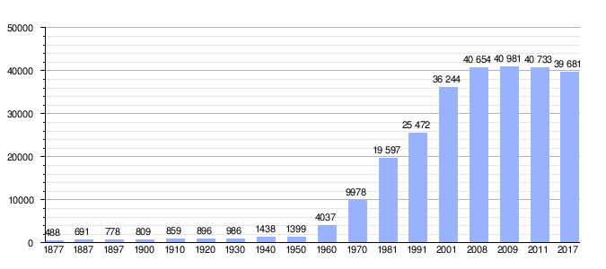
San Fernando has a population, as of 2017, of 39,681 inhabitants, with 19,358 men and 20,323 women. The first demographic explosion occurred in the 1970s, during which the population of the municipality increased doubled. This was due to immigration from other parts of Spain. However, San Fernando de Henares has less population than other nearby towns, such as Coslada and Torrejón de Ardoz, with 91,861 inhabitants and 122,589 inhabitants, respectively, since the residential urban development of San Fernando is conditioned by its administrative limits and geographic, unlike what happened in other surrounding municipalities.
Even so, from the mid-90s of the XX century, to the end of the first decade of the XXI, San Fernando has experienced significant demographic growth with more than 10,000 new inhabitants between 1991 and 2001, an orderly growth, linked in first place to the growth of the residential park of the municipality from the execution of the new neighborhoods foreseen in the PGOU of 1988 whose development accelerates from 1991. To this growth of the 90s and 2000s linked to the promotion of new neighborhoods of Fundamentally single-family housing, we must add the population contributed by new migratory processes that, especially in the 2000s, caused nearly 5,000 new foreign residents to arrive in San Fernando, most of them from Romania. In 2010, the demographic growth of the municipality stagnated, as a result of immigrant return processes induced by fewer job opportunities brought about by the 2008 crisis, and by the vegetative dynamics of the resident population in an aging context, genuine of the current structure of the demographic pyramid throughout the country.
San Fernando de Henares is a municipality that has reached clogging of the available land within its current administrative limits for residential development. This makes it impossible to develop new residential developments, which leads to the more than 400 couples that are created on average a year in the municipality, looking for housing outside of it, giving rise to a process of gentrification in the consolidated area, which translates into a continuous loss of registered population from one year to the next. This problem affects the cultural and historical identity of the municipality due to the loss of roots of its residents, functioning more and more as a neighborhood of Madrid.
| Graphic of demographic evolution of San Fernando de Henares between 1877 and 2017 |
 |
Administration and politics
| Mayor | Start of mandate | End of mandate | Party |
| Angel Fernández Lupión | 1979 | 1981 | Communist Party of Spain (PCE) |
| Enrique Guerra López | 1981 | 1990 | Communist Party of Spain (PCE) United Left (IU) |
| José Luis Copado Calvo | 1990 | 1991 | United Left (IU) |
| Luis Enrique Piñas Panizo | 1991 | 1995 | Spanish Socialist Workers Party (PSOE) |
| Monserrat Muñoz de Diego | 1995 | 2007 | United Left (IU) |
| Julio Setién Martínez | 2007 | 2013 | United Left (IU) |
| Ángel Moreno García | 2013 | 2015 | United Left (IU) |
| Cati Rodríguez Morcillo | 2015 | 2019 | San Fernando de Henares Yes You Can (SFHSP) |
| Francisco Javier Corpa Rubio | 2019 | Currently in charge | Spanish Socialist Workers Party (PSOE) |
| Current mayor | Candidates | ||
|---|---|---|---|
| San Fernando 41384 hab. (21 councilors) Francisco Javier Corpa Rubio ΔPartido Socialista Obrero Español (PSOE) |
|
May 2015
| Party | Votes | % | Councillors | |
|---|---|---|---|---|
| Popular Party | 4802 | 24,62 | 6 | |
| San Fernando de Henares Yes Can | 4653 | 23,85 | 5 | |
| Socialist Workers Party | 4193 | 21,22 | 5 | |
| United Left (Spain)- The Greens | 3208 | 16,44 | 4 | |
| Spain 2000 | 1276 | 6.54 | 1 | |
| Union Progreso and Democracy | 923 | 4.73 | 0 | |
| RED | 162 | 0.83 | 0 | |
| White votes | 345 | 1.77 | ||
| Valid votes | 19508 | 98.57 | ||
| Invalid votes | 284 | 1.43 | ||
| Total | 19,792 (68.7 %) | |||
Councillors of the 2015-2019 government team
- Mayor: Catalina Rodríguez Morcillo (SFHSP-We)
- Councillor for Sustainable Urban Development, Industry, Housing, Works and Infrastructures and Modernization: Joaquín Calzada Salmerón (SFHSP)
- Department of Finance, Employment and Training, Trade, Security and Emergency: Macarena Medel Llorente (SFHSP)
- Councillor for Culture, Education, Youth and Children, Citizen Participation, Personal and Internal Regime, Environment and Mobility: Dona Galán Vivar (SFHSP)
- Councillor for Social Welfare, Equality, Majorities, Sports, Health and Consumer Affairs: Rocío Verónica Vicente Ruiz (SFHSP)
Opposition councilors
- Mayra Pérez (PP)
- Alejandra Serrano (PP)
- Manuel Núñez Malvar (PP)
- Jesus Silvestre Maqueda (PP)
- Enrique Pantoja Bermejo(PP)
- Jesus Sanchez Yáñez (Concejal No Adscrito)
- Sandro Algaba (Spain2000)
- Javier Corpa (PSOE)
- Leticia Martín García (PSOE)
- Francisco Lombardo García (PSOE)
- Guadalupe Piñas (PSOE)
- José García Bejerano (PSOE)
- Sofia Díaz (United Left (Spain)
- Cristina Parrilla (United Left (Spain)
- Antonio Calderón (United Left (Spain)
Past elections
May 2011
| Party | Votes | % | Councillors |
|---|---|---|---|
| United Left (Spain)- The Greens | 8183 | 43,28 | 10 |
| Popular Party | 6944 | 36,73 | 8 |
| Socialist Workers Party | 2584 | 13.67 | 3 |
| Union Progreso and Democracy | 695 | 3.68 | 0 |
| Liberal Democratic Centre | 171 | 0.9 | 0 |
| White votes | 331 | 1.75 | |
| Valid votes | 18 908 | 98.74 | |
| Invalid votes | 241 | 1.26 | |
| Total | 19.149 (69.34 %) | ||
May 2007
| Party | Votes | % | Councillors |
|---|---|---|---|
| United Left (Spain) | 6883 | 37.6 | 8 |
| Popular Party | 6186 | 33,80 | 8 |
| Socialist Workers Party | 4517 | 24,68 | 5 |
| Forum of the Left of San Fernando de Henares | 249 | 1.36 | 0 |
| Citizens of Coslada and San Fernando | 186 | 1,02 | 0 |
| White votes | 283 | 1.55 | |
| Valid votes | 18,304 | 99.51 | |
| Invalid votes | 91 | 0.49 | |
| Total | 18.395 (65.8 per cent) | ||
May 2003
| Party | Votes | % | Councillors |
|---|---|---|---|
| United Left (Spain) | 9364 | 50.73 | 11 |
| Popular Party | 4346 | 23,54 | 5 |
| Socialist Workers Party | 4257 | 23,06 | 5 |
| Democratic and Social Centre | 191 | 1.03 | 0 |
| White votes | 301 | 1.63 | |
| Valid votes | 18 459 | 100 | |
| Invalid votes | 85 | ||
| Total | 18 544 (66.93 %) | ||
June 1999
| Party | Votes | % | Councillors |
|---|---|---|---|
| United Left (Spain) | 8445 | 59.02 | 14 |
| Socialist Workers Party | 2946 | 20,59 | 4 |
| Popular Party | 2359 | 16,49 | 3 |
| Democratic and Social Centre | 226 | 1.58 | 0 |
| Humanist Party | 82 | 0.57 | 0 |
| White votes | 251 | 1.57 | |
| Valid votes | 14 309 | 100 | |
| Invalid votes | 75 | ||
| Total | 14,384 (57.46 %) | ||
May 1995
| Party | Votes | % | Councillors |
|---|---|---|---|
| United Left (Spain) | 5844 | 42,81 | 10 |
| Popular Party | 3634 | 26,62 | 6 |
| Socialist Workers Party | 3290 | 24.10 | 5 |
| Independent of San Fernando de Henares | 491 | 3.60 | 0 |
| Democratic and Social Centre | 155 | 1.14 | 0 |
| White votes | 238 | 1.74 | |
| Valid votes | 13 652 | 100 | |
| Invalid votes | 112 | ||
| Total | 13,764 (67.99 %) | ||
May 1991
| Party | Votes | % | Councillors |
|---|---|---|---|
| Socialist Workers Party | 3496 | 38,23 | 9 |
| United Left (Spain) | 3052 | 33,37 | 7 |
| Popular Party | 1218 | 13,32 | 3 |
| Independent of San Fernando de Henares | 860 | 9,40 | 2 |
| Democratic and Social Centre | 327 | 3,58 | 0 |
| Universidad Independiente Madrileño | 53 | 0,58 | 0 |
| White votes | 139 | 1.52 | |
| Valid votes | 9145 | 100 | |
| Invalid votes | 67 | ||
| Total | 9,212 (48.86 %) | ||
June 1987
| Party | Votes | % | Councillors |
|---|---|---|---|
| United Left (Spain) | 4327 | 40,25 | 9 |
| Socialist Workers Party | 2682 | 24,95 | 5 |
| Democratic and Social Centre | 1390 | 12,93 | 3 |
| Workers' Party of Spain - Communist Unity | 1198 | 11,14 | 2 |
| Federation of Popular Alliance Parties | 1078 | 10,03 | 2 |
| White votes | 76 | 0.71 | |
| Valid votes | 10 751 | 100 | |
| Invalid votes | 112 | ||
| Total | 10 863 (70.20 %) | ||
- Part of this information has been removed from the Wikipedia article Municipal elections in San Fernando de Henares
Economy


San Fernando de Henares is currently a city oriented to the service sector and industry within the metropolitan area of Madrid, which is located in an optimal environment for the implementation of economic activities linked to manufacturing and logistics, with very good conditions of accessibility by road as it is located in an important communication hub within the Madrid metropolitan region, around the axis of the A-2, better known as Corredor del Henares, close to the Madrid-Barajas airport and its air cargo center, to the Transportation Center and the Coslada Railway Dry Port, in addition to being very well connected by road through the large metropolitan highways M-45, M-50, M-21 and A-2.
It has a modern Business Park that offers space for offices with commercial areas and integrated services of modern conception and design, as well as a Municipal Business Center, which provides low-cost space for the development of new business initiatives. Among the established companies, some important ones related to leading sectors such as INDRA or IBM stand out. Currently, new industrial estates are being developed to house new companies linked to the logistics and manufacturing sectors, highlighting the recent urbanization of the Puerta de Madrid Industrial Estate, which, with more than 3 million square meters of land, has already housed since October 18, 2012 the logistics center of the Amazon company in Spain.
A sector for commercial, tertiary and leisure uses is also being urbanized around the A-2 motorway next to the Jarama river and to the north of the Madrid-Zaragoza railway in expectation of future development, although the same area has already been They are located a large commercial area, such as Carrefour, which was one of the first shopping centers in the Madrid area, opened in 1984 initially by the PRYCA brand, and more recently, a park of medium-sized surfaces called "Camino Real& #3. 4; among whose trademarks is DECATLON.
San Fernando de Henares, is the municipality of the Henares Corridor after Alcalá de Henares with the largest amount of land available for productive activity and is called to be one of the main economic engines of the region, the challenge being that this wealth, may be reflected in employment located in the municipality itself, although, as San Fernando participates in the complex economic dynamics of the Madrid metropolitan area, the residents of the municipality work in various areas of Madrid, mostly in the sector services, although the polygons located in the municipality are currently the ones that employ the most labor from the population located in the same. Despite the foregoing, the industrial estates and companies located in them already report to the municipality an important part of the collection via taxes with which the City Council is financed, contributing within the current change in the economic cycle towards a new expansive stage, by progressive reorganization of municipal accounts, which close with a large surplus since 2015, allowing San Fernando de Henares, with less population registered in the census than other large municipalities in its surroundings, to have proportionally higher incomes and to maintain quality public services through efficient management of these resources, the municipality being fully viable in economic terms, guaranteeing its independence as such.
Among the future challenges for the development of the full potential of the new industrial estates, is the improvement in the maintenance, cleaning and waste management of the current industrial zones, as well as the creation of road, energy and transport infrastructures. necessary public transport, for which the City Council will need the involvement and cooperation of other competent administrations such as the regional government of the Community of Madrid or the Government of Spain through the Ministry of Public Works.
Communications
By road
Direct access from the A-2 (km 15), M-40 and M-45 (exits 27 and 32). It also has a very close exit from the R-3. (Mejorada del Campo-Velilla de San Antonio)
Bus
Interurban lines
| Line | Tour |
|---|---|
| 220 | Torrejón de Ardoz - San Fernando de Henares |
| 280 | Coslada (FFCC Station) - Hospital del Henares - Loeches |
| 281 | Madrid (Avenida de América) – San Fernando de Henares |
| 282 | Madrid (Avenida de América) – San Fernando de Henares - Improved Camp |
| 283 | Madrid (Avenida de América) – Coslada - San Fernando de Henares |
| 284 | Madrid (Avenida de América) – Velilla de San Antonio - Loeches |
| 285 | Coslada (FFCC San Fernando Station) – San Antonio Velilla - Arganda del Rey |
| 287 | Madrid (Alsace) – Coslada (Barrio de la Estación) |
| 288 | Madrid (City Lineal) – Coslada - San Fernando de Henares |
| 822 | Madrid (Aeropuerto) – Coslada - San Fernando de Henares |
| N203 | Madrid (City Lineal) – Coslada - San Fernando de Henares - Velilla de San Antonio / Loeches |
Urban lines
| Line | Tour |
|---|---|
| 1 | Industrial polygon - C.C. San Fernando |
Subway
.jpg)
| Station | Lines | Services | Area |
|---|---|---|---|
| San Fernando | |||
| Jarama | |||
| Henars |
Commuters
| provenance/destiny | ► station | Line | station oriented | destination/procedurement |
|---|---|---|---|---|
| Chamartín | Coslada | Torrejón de Ardoz | Guadalajara | |
| Prince Pio | Alcalá de Henares | |||
| Cercedilla | Guadalajara | |||
| Chamartín | Source of the Mora | CIVIS |
Health

In the municipality of Coslada is the Henares hospital, opened in February 2008, thanks to which it is not necessary to go to another hospital in Madrid to be treated for certain pathologies, although its portfolio of services is less than that of the La Princesa hospital, which continues to be, depending on what, the reference hospital. The municipality has two primary care health centers, the one on Córdoba street being the first to be opened by the then National Health Institute (INSALUD) dependent on Social Security at the end of the 1970s, that a second primary care center would be added in 1997, in the Parque Henares neighborhood, located in the Ondarreta square of the same, which came to respond to the primary care needs of the municipality when it already exceeded 30,000 inhabitants, this The second center, built before the powers in health management were transferred to the Community of Madrid, would be inaugurated by the Minister of Health, José Manuel Romay Beccaría and the then mayoress, Monserrat Muñoz. In Coslada, and until the opening of the Hospital del Henares, which already brings together the outpatient clinics for clinical specialties, a specialty center was built in 1987, called Doctor Jaime Vera, in which the outpatient clinics for medical specialties and diagnostic tests, as an outpatient step prior to hospital care. This specialty center in Coslada, currently underutilized, provided service in addition to this municipality and San Fernando, to those of Mejorada del Campo, Velilla and Loeches, the same ones currently served by the hospital, which as such has a regional character. In addition to the health services provided by the competent administrations, the San Fernando city council maintains a "Municipal Health Center" Created by the first democratic city councils in the early 1980s, it has dealt with health policies such as family planning, care for drug addicts, sexual education, and STD prevention, which included testing for early detection of infections such as those of the HIV. This Municipal Health Center, whose work has been closely linked to the Municipal Social Services, has developed the Municipal Health Plan, and managed the "San Fernando Saludable" since the mid-1990s, with pioneering policies in social and health matters, which have led San Fernando to be the only city in the Community of Madrid, declared a Healthy City in 1999 according to the WHO, among 23 other European cities that also have this award.
Culture
Cultural areas


In the municipality there are the following spaces for culture, where the city council develops a diverse activity to promote it:

- Teatro Federíco García Lorca, of municipal property. With more than 500 localities, theatrical works or film sessions are held. Next to this is the cultural center of the same name, endowed with classrooms workshop for different thematic courses (painting, sculpture, photography, performing arts, etc.).
- Exhibition hall Juan Carlos I, recovered space for small exhibitions of painting, photography, etc. In what was the Chapel of the former College of El Pilar in the Plaza of Fernando VI.
- Gabriel Celaya Cultural Center, with a small auditorium with capacity for 250 localities, and a temporary exhibition room, in the same square as the previous one.
- Rafael Alberti Central Library. It is located in Calle de la Libertad, in the old town, in the rehabilitated building that since the centuryXIX it hosted the Town Consistorial House, until in 1999 it moved to its current headquarters in the building that integrates the remains of the Royal Paños Factory. It has study rooms, a hemeroteca and areas suitable for different cultural activities.
- Museum of the City, equipment located in the rehabilitated barn of the number 16 of the Plaza de España, which was thought to be a center of historical interpretation on the Real Site of San Fernando, as a city with illustrated fabril origin, which is currently closed and unequated since 2011, within the dispute that takes place since 2012 with the Plaza de España del municipio, due to problems of management with the company created in its day for rehabilitation, which included the building of the granero,
- Centro Cultural Mario Benedetti, located in the most recent area of construction south of the city, has a small multipurpose auditorium, and integrated a children's house, where various play and cultural activities are carried out for the children's public. It counted until September 2012, with a small neighborhood library, for children and youth, which was closed for reasons of budget adjustment, being less equipped than the current central library Rafael Alberti in the center of town.

Places of Interest


There are several places of special interest in the municipality:
- El Conjunto Urbano del Real Sitio, formed by the Plaza de España and its buildings, remains of the Real Fábrica de Paños, the Plaza de Fernando VI and streets that irradiate it, were declared a Historic Artistic Site by Royal Decree in 1983, retaining the same layout as at the time of the creation of the municipality in the centuryXVIII, where the original buildings of the houses of the Operators of the Real Factory were preserved in the square square square, reconstructed and/or rehabilitated in 2012 maintaining its original style, in front of the facade of the Real Factory, restored and integrated in the new town hall in 1999. The Plaza de España has always been the main square of San Fernando and is today the heart of the city in which its historical memory rebuilt from the illustrated values that inspired its foundation. In the round square, called Fernando VI, is symbolically located in its center, the statue of said king, promoter of the foundation of the Royal Factory and new population linked to it, moved from the Royal Palace to the municipality in 1844 during the reign Isabel II, the square, is a geometric center of the current urban plot of the municipality of which the eight streets that structure it. All this built complex and its urban design, is representative of the illustrated urban ideas of the first half of the centuryXVIII.
- The Paseo de Los Chopos, called del Molino, which in the past linked with the square of Fernando VI, through the current street of La Huerta that was one of the tree-lined walks that joined the population with La Vega and the river. It is along with the Paseo de los Plátanos, called before El Cardón, one of the main tree-lined walks that bordered the “Big Garden” in addition to the Paseo de La Agujeta that runs parallel to the urban area, being one of the most fertile orchards irrigated by the Jarama River. These walks give access to other natural enclaves of the municipality within the southeast regional park which occupies 29 of the 39 km2 of the municipality. It forms this set of tree-lined walks, hunts and orchards, a sort of space that combines historical-artistic and environmental values on the urban edge of town, highly valued for the recreation of neighbors, maintaining their secular agrarian activity. Highlight in them, in addition to the tree-lined walks, the original irrigation system of the orchards of the Royal Site, with its caz, locks, bridges and doors like that of the King and the Queen, as well as the remains of a hunting place in what was the central square of the Huerta Grande, which dates from the beginning of the centuryXX.. Although it is not comparable to the unequal state of conservation and its historical origin and becoming, the Huerta Grande del Real Sitio de San Fernando, is a reflection of those of Aranjuez, a population of contemporary foundation to San Fernando.
- Aldovea Palace Castle, located east of the border and adjacent to Torrejón de Ardoz, near Parque Europa, was a typical medieval castle, transformed in the centuryXVII in a palace characteristic of the time. It is rectangular with four towers at the angles, undoubtedly replacing the cubes of the medievo towering castle. It is structured in three floors, separated by a continuous imposta and rematized by alero as a medium-flight cornice, being routed is at its bottom by modillones. The walls are seen brick, using the stone in the socket, the moulds and in the chains that reinforce the angles of the towers. Its main façade slightly retranqueada with respect to the two lateral towers presents in its central axis a flanked cover with fasted columns and renamed on its top by a broken frontispiece, in whose center is the shield of Spain and the royal crown on the top, being crowned by a sculptural group of angels holding a cape and on the sides a pedestal characteristics of the ballXVIII. On the floor below the sides of the main door and on the socket are opened three openings of windows with bars on each side, on the main floor and on each of the windows, simple balconies and on the upper floor with bars, being crowned with triangular frontons that are at the ends of the towers, being this an added centuryXVIII. The lateral and posterior facades have the same distribution as the main facade. As for the floor of the house-palacio we know that the rooms are organized around a courtyard, which receive air and light the rooms and which are accessed by a zaguán from the front door. The distribution is as follows: on the ground floor stables, garages and kitchen, on the main floor the halls, chambers, antechambers, cabinets and main alcoves, and on the upper floor the rooms for servants and other accessories. The communication between the floors is made through the main staircase of wooden steps, another secondary one that accesses the kitchen and two of snails that from the main floor communicates the towers and devanes. Another singular element are the French-style fireplaces. The roof is tiled, with large wooden aleros. The house-palacio therefore has the same characteristics in an urban palace of Madrid of the centuryXVII. In front of this house-palace there is a hermitage, called the Magdalena, and currently in ruins, as well as the house of the guard. This castle must have been lifted by the end of the centuryXI or early centuryXII It was probably a fortress, whose importance was of a strategic nature as it was located on the banks of the Jarama. By this same time you will find the first references to the castles of Aldovea in a document where it is said that in 1154 was given the Villa of Improved to the Archbishop of Toledo, as well as the nearby castle. We don't know much about the castle until the century.XVI; in 1570 there is information made by Mr.Michael de Silba, a senior accountant of the archbishop's rents, about the works that the castle of Aldovea needs, and in 1599 the repairs are made in it. In 1715 there is a fire in the stables and birds, causing their total ruin. The castle and part of the property were modified during the centuryXVIII as is seen in the "Plano del Soto de Aldovea" made by Damián Mota on the occasion of the attachment, deslinde and garliction of the term in 1790 before the sale of the possession to Manuel Godoy. At this time, the castle had already acquired the current configuration. In 1804, Manuel Godoy sold him to King Charles IV and from here he was incorporated into the real estate in the Royal Site of San Fernando along with his sotos. The Royal Patrimony belonged until in 1869 in which by the disabling of the crown goods, it was auctioned, being acquired the castle and its lands by the family Figueroa Bermejillo, Marqueses de Gauna and dukes of Tovar (one of the branches of the Romanes family). This duke of Tovar possessed of a famous bravas cattle ranch in the surroundings of the castle turned him into a palace residence. He is still from the same family, the Dukes of Tovar.
 Humedal de "La Guindalera", one of the natural enclaves in the Southeast Regional Park.
 - Historical Archive of the City located in the Plaza de España within the halls and contains historical documentation since the creation of the municipality. Since 2011, the municipality has a new unique building for MUSEO DE LA CIUDAD, which remains unequipped.
- Parroquia de la Purificación de Nuestra Señora [2], although the building of the temple, built in 1965, lacks all architectural interest, because it is a "nave" of almost industrial design, whose dignity was left to the goodness of the materials. The pilasters in granite can be seen from one of the historic gates of the city, specifically those that gave access to the Huera Chica, part of which the parish rises in the neighborhood of the same name. The origin of the doors is the same of those of the King and Queen who are located in the Huerta Grande or La Vega, as well as the one that gave access to the Real Casa de La Administración, which currently gives access to the Juan Carlos I Exhibition Hall in Fernando VI Square.

Tapas route
Since 2008, the San Fernando de Henares City Council has celebrated the Tapas Route, a gastronomic route that passes through several bars and restaurants that offer to taste a tapa. Any hotel establishment can be registered, and the objective of the council is to promote the gastronomic offer of the town. This route is celebrated in the month of April, although the days vary.
Sports
The local soccer team, Club Deportivo San Fernando de Henares, plays in the Third Division of Spain and played in the promotion league to Second Division B in the 2006/2007 season. In it he surpassed the 1st round in which he played against C.D. Roquetas, and in the 2nd round he was eliminated with C.D. Denia. However, in the 2007/08 season it fell to the lower category. Play at the Santiago del Pino Stadium.
- Interest data regarding the trajectory of the San Fernando de Henares Sports Club
- Seasons in 1.a: 0
- Seasons in 2.a: 0
- Seasons in 2ndB: 0
- Seasons in 3.a: 37 with the new Season 2019-2020
- Seasons in Prefente: 9
- Seasons in 1.a Regional: 1
- Seasons in 2.a Regional: 10
- Seasons in 3.a Regional: 5
- Season at 4.a Regional: 6
- Greatest goal achieved as a local: - CD San Fernando 15 - 1 Illescas - 1967/1968
- Greatest goal as a visitor: - Preview 3 - 8 CD San Fernando - 1964/1965
- Greatest goleada fits as local: - CD San Fernando 2 - 8 CD Ciempozuelos - 1957/1958
- Greatest goal fits as a visitor: - Talavareño 13 - 1 CD San Fernando - 1955/1956
- Record goals scored:102 goals - 1971/1972
- Matched goals:91 goals - 1957/1958
- More points scored:79 points - 2008/2009
- Fewer points achieved:3 *points*sanction - 1957/1958
- Most repeated position in the Third Division (7.o on 6 occasions.)
- Best position: - 3.a,:3.a,y 5.a Season 2006/07 and 2015/2016
- Worse position: - 3.a;: 19.o, Season 1989/90 and 1998/999
- Palmarés
- Preferential Champion:(4) - 1977/1978,1986/1987,1990/1991 and 2008/2009)
- 3.o Regional Champion: (1) - 1962/1963)
- Madrid Community Cup Champion:(2) - 1983/1984,2002/2003)
Summer Tournaments
- Alcarria Trophy:(1):-1978
- Trophy XXXVIII Trophy of the villa Navalcarnero:(1):-2016
San Fernando de Henares has also had a team in the EBA basketball league called DISERMODA SAN FERNANDO, in the 2001/2002 season. In the 2002/2003 season it changed its name to LEE COOPER SAN FERNANDO, and in the 2004 season, until its disappearance, it changed its name to DRIBLING SAN FERNANDO, which dropped after many seasons bordering on relegation. In the 2001/2002 season they were fourth in the standings with 50 points behind REAL MADRID B, who were 3rd with 52 points.
In 1982, the arrival of the 16th stage and the departure of the 17th stage of the 1982 Cycling Tour of Spain were organized, the year in which Kelme, Reynolds and Teka still existed as leading teams. It also hosted some stages, such as the last stage of the 1998 and 1999 Vuelta a España.
In September 1992, the final of the Community of Madrid tournament was played between El Estudiantes and Real Madrid at the inauguration of the San Fernando Sports Center Pavilion.
- Sports facilities

San Fernando has numerous sports facilities. The most important facilities are those of the municipal sports center, where there are the municipal swimming pools for summer use, the indoor heated swimming pool, the urban spa (closed due to lack of influx of users), municipal tennis courts, as well as basketball courts. and handball as well as the Santiago del Pino Municipal Stadium equipped with athletics tracks, and other smaller soccer fields made of artificial grass or clay.
The Parque Henares Pavilion is located on Calle Vitoria and has three basketball courts, one for futsal and a karate "dojo".
The Camino de la Huerta Pavilion is located on París street, and is equally equipped as the previous one.
The M-3 Pavilion, located on Rafael Sánchez Ferlosio street, has a similar equipment as the Camino de la Huerta Pavilion, with a different configuration.
There are different outdoor sports courts for non-regulated use for basketball practice distributed throughout the municipality, as is the case of the ones located on Avenida de San Sebastián and Parque Eugenia de Montijo, in addition to those existing in the park Dolores Ibárruri, which has a dirt soccer field.
Media
Press
- Sanfer to Day
- The FifthHenar Corridor newspaper.
- Calle de la Libertad, city council magazine that is delivered every month to all neighbors.
- More national press.
Radius
- Zero wave (Alkala and coslada).
- SER Henares (Rama de la Cadena SER).
- 40 main Madrid.
- Kiss FM Madrid.
- Radio Marca.
- Europa FM.
- Radio 4G.
- More national chains.
Television
- TV San Fernando, the TV of San Fernando de Henares online.
Contenido relacionado
Charlotte of Mexico
Halberd
Mexica religion