
San Cristobal (Venezuela)
San Cristóbal is a Venezuelan city, capital of Táchira State and San Cristóbal Municipality, located in the Andes Region of southwestern Venezuela. It is located 57 kilometers from the border with Colombia. The city is nicknamed The City of Friendliness. It was founded by Juan Maldonado Ordóñez y Villaquirán, captain of the Spanish army, on March 31, 1561. It has a projected population of 485,872 inhabitants for the year 2015, while the entire metropolitan area has a population of 1,250,512 inhabitants.
History
Pre-Columbian times

The area where San Cristóbal is currently located was inhabited since 5000 B.C. C. by semi-nomadic human groups with a simple social organization governed basically by family ties, without established central power. Around 1500 B.C. C. they were already organized in small villages of light constructions and they practiced a highly developed hunting, gathering of fruits and roots, they built dikes and made use of slash and burn in their crops, whose main item was corn. In this period, the elaboration of ceramics destined for very varied uses such as vessels, some of them pinkish in color and others white with traces of red; plates, anthropomorphic figures, pyriform funerary urns and giant plates where they supposedly served their food during some ceremonies.
They developed the clothing industry in comparison with the other tribes in the country, using cotton and sisal that they themselves grew; there were "mohares" a kind of priests, sorcerers or doctors who directed religious acts and curing diseases. They worshiped the sun, the moon, snakes, lagoons, moors, peaks and meteorological phenomena. They saw bad omens in the rainbow, because they believed that its influence was evil. Among their social rites they practiced marriage and mourning for the deceased relative; men selected their spouses for their garment-making skills, their good health, and their robustness. It should be noted that in the San Cristóbal valley lived tribes from the 2 great families that inhabited pre-Columbian Venezuela; the Arawaks and the Caribs. Represented by the Simaracaes tribes towards the Santa Teresa sector; the Táribas to the north of the city, and the Teucaras in the Barrio Obrero, Barrio Sucre and La Concordia sectors. The Jirajaras inhabited the sector that currently bears the same name. The nation of the Tororos, Quinimaríes and Azua settled at the southern end of the city and these were allied tribes, they lived in a village called Cania, which was the one that the conquistadors got when they arrived in the valley in 1547.
Colonial Period
In the year 1547 Alonso Pérez de Tolosa left El Tocuyo for the Andean mountains on a mandate issued by the governor of said city; On his journey he went up the Apure River, then crossed the Uribante River to later reach the San Cristóbal Valley; from there he traversed what was then called Lomas del Viento and finally reached the valley of Cúcuta; becoming the first European to sight the area on which San Cristóbal would settle. In 1558 Captain Juan Rodríguez Suárez left from the town of Pamplona with the mission of exploring the Venezuelan Andes; Making his journey from the Zulia and Táchira rivers, he ascended the Lomas del Viento to enter a wide valley that he called Valle de Santiago, this being the current valley of the Torbes river. After several days of traveling he arrives at another valley which he calls La Grita; continuing north through the valley of Las Acequias where he founded the city of Mérida without having authorization to do so. Faced with this insubordination, Captain Juan Maldonado y Ordóñez de Villaquirán is sent to capture him, in addition to this he was invested with the power to settle and found; power that he would exercise later when moving and officially founding the city of Mérida in its current location.
This is how the Spanish captain arrived together with 35 people, including soldiers and civilians, to the aforementioned Valle de Santiago on March 31, 1561 to strictly found the Villa de San Cristóbal, on the condition that the villa was exempt from the jurisdiction of Pamplona. With this foundation, the first manifestation of territorial sovereignty in regards to the natural border with New Granada, today Colombia, is marked in the history of Venezuela; it also becomes the second civilized populated center in Andean lands. The foundation took place on the indigenous settlement of Las Auyamas, this location was chosen by the conqueror due to its strategic position from which the town could be defended by its four cardinal points against the attacks of the indigenous people, who on several occasions came to seriously threaten the survival of the city. The historical act of the founding of the city reads as follows:
"Captain Juan Maldonado O. V. mastered by terms of La Villa for now and forever; towards the band of the city of Pamplona, to the river that they call Cúcuta, by limits for the justices of this Villa and for those of that city of Pamplona... that cannot pass with a rod of that river of Cúcuta to this part or of this Villa to the other unless it was the greatest justice of that city... For the Merida band to what they call the Hondo People. From the East band to the plains of Venezuela. By the band of the west to the lagoon of Maracaibo and Herinas' arms so that no justices of another jurisdiction enter in such terms... Thus the founder in His Majesty's name applies them by appropriate terms for this bliss Villa de San Cristobal"(sic).
The newly founded "Villa de San Cristóbal" received constant attacks from the indigenous peoples of the region, until 1578, the year in which Captain Rodrigo de Paradas, who at that time was mayor of the city, stopped said attacks after confronting the hostile populations, to get rid of the fights with The Indians, the neighbors, invoked the protection of San Sebastián, whose martyrdom had occurred with arrows. For years, San Cristóbal ceded in importance to the city of La Grita, however, already in 1856 when the state of Táchira was instituted, San Cristóbal was named capital of the same. The historical archive of the city was lost during the War of Independence, so the records prior to 1820 are not preserved.
Republican period

The city became an important trading center for cocoa and coffee (from Martinique from Guyana) at the end of the 19th century and thus a center of European immigration linked to this same industry. It also received important influence from Colombia given its isolation from the capital of Venezuela due to, at that time, poor communication routes, which influenced the customs and culture of the city. On May 18, 1875, the city suffered severe damage from the Cúcuta Earthquake. During the governments of Cipriano Castro and Juan Vicente Gómez, at the beginning of the 20th century, the first improvements were made to land communication between the Andes and the capital (trans-Andean highway), which led to an important part of the young academics of the city to the capital of the country with the consequent exchange and opening of customs.
A second wave of European immigrants arrived during the 1950s as a consequence of the opening made in this sense by the government of President Marcos Pérez Jiménez; the climate of the city, its pro-European atmosphere and the circumstance of being one of the few cities in the country practically free of the problem of the malaria pandemic, apart from the immigration of this time it attracted the city and the state of Táchira in general.
The founding of several academically significant campuses during the 1960s and 1970s steadily attracted students from across the country. Since then, an extensive academic and cultural activity has been carried out in San Cristóbal.

Persons born in San Cristóbal
- Juan Pablo Peñaloza, (1855-1932), military and political leader.
- Pedro María Morantes, (1865-1918), lawyer, writer and political activist.
- Rafael de Nogales Méndez, (1878-1936), writer and military.
- Marco Antonio Rivera Useche, (1895-1990), musician and teacher, hymn composer of the San Cristobal.
- Miguel Angel Espinel, (1895-1968), musician and teacher, composer of the Hymn of the Táchira State.
- Isaiah Medina Angarita, (1897-1953) President of Venezuela (1941 - 1945).
- José Ignacio Baldó Soulés, (1898-1972), a founding physician of the Society of Tisiology of Venezuela.
- Manuel Felipe Rugeles, (1903-1959) poet and journalist Generation of 1918.
- Luis Felipe Ramón y Rivera, (1913-1993), musician and folklorist, composer of Brisas del Torbes.
- Chucho Corrales, (1926-1998), musician and singer, composer Andinita, Tailored land and others.
- Angel Vivas, (1956), Brigade General of the Venezuelan Army.
- William Méndez, (1958) sportsman and politician, selection of Venezuelan football, former mayor of San Cristobal.
- Edgar Ramirez, (1977), an actor with a wide trajectory abroad.
- Tomás Rincón, (1988), footballer of Venezuela's soccer team, currently militating in the Torino F. C.
- Mikel Villanueva (1993), footballer of Venezuela's soccer team. Study at the Metropolitan College playing football tournament champion in 2010.
Patron Saint of Saint Christopher
Every January 20th is celebrated the day of the patron saint of the city: San Sebastián, in whose honor a Eucharist is held with the priests and some bishops who come to honor the patron saint of San Cristóbal and a serenade is also performed in the atrium of the Cathedral.
The tradition of the San Sebastián festival dates back to colonial times. Aurelio Ferrero Tamayo founds the ancestral origin of the festival of San Sebastián in the following documents: The first document was supplied in the investigation carried out by Father Agustino, Agustín Campo del Pozo, on the Virgin of the Consolation of Táriba, and dates from the year 1664. Said document states that: "In the Villa de San Cristóbal, on December eighth of one thousand six hundred and sixty-four years, Mr. Br. Don Nicolás de Menis Ortiz, Pbro. Judge, in accordance with his commission, went to the parish church of this Villa, in which he found the greatest gathering of his parishioners together and congregated, to take the miraculous Image of Our Lady of Táriba to her hermitage, which was made in the following form and manner: the Holy Cross left said parish in the form of a procession with the invocations of the Blessed Martyr San Sebastián and the invocation of Nuestra Señora de la Concepción, who is from said holy hermitage." (Campo del Pozo, 2001:47) Here clearly allusion is made to the ADVOCATION of the revered image of San Sebastián. The second document was supplied by Dr. J. J. Villamizar Molina, chronicler of the city, and dates from November 14, 1749. The document can be found in the National Historical Archive of Colombia, Book of Hospitals and Cemeteries, volume IV. And it highlights the construction of a hospital for the Villa, where the Church of San Sebastián was formerly founded.
In 1911, a fact was recorded that drew a lot of attention, since Saint Sebastian was attributed the same gift that thaumaturgeous kings had; This is how the thaumaturgy of San Sebastián is expressed: "in a very solemn manner, the patronal feast consecrated to the glorious thaumaturge Saint Sebastián was celebrated yesterday in the Holy Mother Church. The temple was invaded by our select audience (...) the procession was admirable, due to the order and holy fervor that prevailed in it." The religious festival became the space par excellence to express the gregarious feeling and social sharing, which which enabled regional integration through the participation of neighboring towns. The festival of San Sebastián acquired its cathartic meaning when music ceased to accompany religious processions and became part of public and private retreats and dances. A look at the musical groups born in San Cristóbal during the first half of the XX century.
Saint Sebastian is a saint venerated by the Catholic Church and the Orthodox Church. He was a soldier in the Roman army and the Emperor Diocletian, who - unaware that he was a Christian - came to name him head of the first cohort of the imperial Praetorian Guard. He was born in Narbonne (France) in the year 256, but was educated in Milan. He complied with military discipline, but did not participate in pagan sacrifices, considering them idolatry. As a Christian, he exercised the apostolate among his companions, visiting and encouraging other Christians imprisoned because of his religion. He ended up being discovered and denounced to the Emperor Maximian (a friend of Diocletian), who forced him to choose between being a soldier or following Jesus Christ.
The saint chose to follow Christ. Disappointed, the emperor threatened him with death, but Sebastian remained firm in his faith. Enraged, he sentenced him to death by fire. The emperor's soldiers took him to the stadium, stripped him naked, tied him to a post, and rained arrows down on him, leaving him for dead. However, his friends came over and, seeing him still alive, took him to the house of a noble Roman Christian named Irene, wife of Cástulo, who kept him hidden and treated his wounds until he was restored.
His friends advised him to stay away from Rome, but Sebastian flatly refused. He appeared before the emperor, who, baffled, considered him dead, and strongly reproached him for his conduct in persecuting the Christians. Maximian ordered him to be flogged to death, and this time the soldiers fulfilled the mission without mistakes, throwing his body into a quagmire. The Christians picked him up and buried him on the Appian Way, in the famous catacomb that bears the name of Saint Sebastian. He died in the year 288.
Geography

Limits
- North: with the municipality of Cárdenas.
- South: with the municipalities Torbes and Córdoba.
- East: with the municipality of Cárdenas.
- West: with the municipalities Libertad and Independencia.
San Cristóbal is located on a wide alluvial terrace with a slight inclination towards the west; along a plateau that emerges from the foothills of the La Maravilla mountain range and culminates on the banks of the Torbes River. The plateau is drained by numerous streams that run through small canyons such as La Parada, La Bermeja, La Romera, Potrera, etc; that divide the city transversely into several well-defined sectors. As a consequence of this topography along the entire Torbes valley, the city presents a remarkable amplitude in its absolute unevenness, however due to the extensive length of the plateau -approximately 14 km- this manifests itself gradually and is little steep slopes common. Its lowest point is the Sabaneta sector, to the south of the city, and it is 810 m a.s.l. no. m. while its highest point is located at 1350 m s. no. m. towards the Cueva del Oso - Altos de Paramillo sector; and Colinas de Pyrenees northeast of the city. However, there are some residential areas located at more than 1500 m s. no. m. most of these to the east of the city. The official altitude was established at Plaza Bolívar (900 m a.s.l.) located in the center of the city.
The pattern of winds in the city runs from south to north. Said flow of winds coming from the plains is directed along the Torbes valley, where the surrounding mountains act as a funnel, causing permanent gusts of wind to the south of the city. This phenomenon is manifested to a greater extent in the Chorro El Indio park, in a section of the highway called Loma del Viento; whose intensity has eroded the vegetation layer of the sector and has deformed the few shrubs present in the place.
Climate
It has a high-altitude tropical climate, influenced by its altitude, located at the beginning of the Venezuelan Andes Mountains, located at an average height of 900 m s. no. m., which sets its temperature and provides milder days, with temperatures that do not usually exceed 29 °C.
The average temperature of the city is 20.5 °C, with averages of 26 °C during sunny hours and 16 °C at night.
The rate of insolation in the city is relatively low, due to the great cloud cover that covers the city during a large part of the day, with few hours of sunshine in the city during the daily average, maintaining a UV index of no higher at level 10 for much of the year.
| Month | Ene. | Feb. | Mar. | Open up. | May. | Jun. | Jul. | Ago. | Sep. | Oct. | Nov. | Dec. | Annual |
|---|---|---|---|---|---|---|---|---|---|---|---|---|---|
| Temp. max. abs. (°C) | 30 | 31 | 31 | 31 | 32 | 31 | 30 | 31 | 32 | 32 | 31 | 29 | 30.9 |
| Average temperature (°C) | 24 | 25 | 25 | 27 | 24 | 24 | 24 | 24 | 25 | 25 | 24 | 24 | 24.6 |
| Average temperature (°C) | 18 | 21 | 21 | 21 | 22 | 20 | 21 | 20 | 20 | 22 | 21 | 19 | 20.5 |
| Temp. medium (°C) | 14 | 15 | 17 | 17 | 17 | 17 | 16 | 16 | 18 | 17 | 16 | 14 | 16.1 |
| Temp. min. abs. (°C) | 6 | 8 | 11 | 12 | 12 | 9 | 10 | 13 | 10 | 10 | 8 | 9 | 9.8 |
| Total precipitation (mm) | 27.5 | 21.3 | 39.2 | 101.6 | 158.0 | 198.0 | 201.9 | 164.2 | 141.8 | 137.9 | 106.2 | 60.4 | 1358 |
| Hours of sun | 161 | 167. | 170 | 161 | 182 | 144 | 149 | 139 | 157 | 179 | 175 | 145 | 1929 |
| [chuckles]required] | |||||||||||||
Altitude
Relief of the municipality of San Cristóbal Height above sea level of San Cristóbal - Táchira State
The city of San Cristóbal, capital of the San Cristóbal municipality, is at an altitude of 900 ms. no. m. that is (2,953 feet), this is 3,012 below Pico El Púlpito (3,912 m a.s.l.), the highest point in the State tachira Its lifting points are:
- Minimum height: 810 m. n. m. Sabaneta
- Average height: 900 m. n. m. Central helmet
- Maximum Altitude: 1,670 m. n. m. High part of the city
Urbanism
According to the INE, it is the second metropolitan area with the lowest poverty rate in Venezuela. The old town of San Cristóbal is characterized by having narrow streets and houses with high colonial-style ceilings, which gives it an appearance that distinguishes it from the rest of the urban context. This sector was the shelter for most of the San Cristóbal population until the mid-1950s, when the demographic growth attributed to foreign immigration began, which began to settle in areas far from the traditional urban center, standing out only before the decade mentioned the expansion project that would later become the most emblematic urbanization of the city, known as "Barrio Obrero" for being financed at that time by the now defunct Banco Obrero for the growth of the city's middle class. It has architectural samples of the art nouveau style, which prevailed at that time. With the growth of these urbanizations, the Pirineos urban area was born in the 1960s, and designed for both the wealthy classes and the middle class, which includes the Pirineos, Sinaral, Bajumbal, Altos of the Pyrenees, and the houses and apartments financed by the National Housing Institute (INAVI) of a public nature, Pirineos I, II and III, Quinimarí urbanization, which promoted the growth of the city to the north and east of it.

The construction of the fair complex in the north of the city gave way to the growth of the "Pueblo Nuevo" and the communication of this area with the growing urban development of the northwest on the road to Táriba (urbanizations Las Lomas and Santa Teresa).
Towards the south and southwest, the popular areas of the city have traditionally been located, such as the urbanization of San Sebastián, el 23 de enero and Madre Juana. From center to south and connected by the Nuevo and Viejo viaducts is La Concordia parish, a populous residential area and main industrial sector of the state, where the Neighborhood Unit is located, the first low-income housing project with public capital that was built in San Cristóbal.
In the 1980s, new demographic growth prompted the construction of new housing complexes (Quinimarí and Los Teques urbanizations, among others), some of which have caused the need for the simultaneous construction of new roads and service sectors.
Urban Environment
The San Cristóbal metropolitan area sits on the wide valley of the Torbes river and its great alluvial terrace, serving this river as the axis from which most of the urban units that make up the conglomerate radiate.
The southern end is at 670 m s. no. m. and it is where the Vega de Aza sector is located, on the outskirts of San Josecito (Torbes Municipality). Towards the north, entering the Andean mountain range, the towns of Cordero and Palmira (Andrés Bello y Guásimos Municipality) are located, at an average altitude of 1300 m s. no. m., reaching the highest point of the conurbated geography in the Monte Carmelo sector (Andrés Bello Municipality) at 1,670 m s. no. m., in the limits of the city of Palmyra.
To the west are Libertad and Independencia, two municipalities in Tachira, also known in popular slang as "Capacho" indistinctly; This is due to the fact that in the past both populations formed a single settlement, later divided as a result of a great earthquake that separated them geographically; However, as a result of the urban expansion experienced in the last decades, these two populations are totally merged at present. Similarly, several secondary population centers settled in this area such as Zorca (Cárdenas Municipality), El Valle, Berlín (located in the Junín municipality), Peribeca (Independencia Municipality), Tucapé (Cárdenas Municipality), Caneyes (Guásimos Municipality), and El Tambo (located in the Córdoba Municipality). It is estimated that these last two municipalities will be incorporated into the conurbation in the future, due to the continuous expansion of urbanized areas from Greater San Cristóbal to their respective capitals (the cities of Rubio and Santa Ana del Táchira).

Government
San Cristóbal Municipality is currently governed by Mayor Silfredo Zambrano, of the United Socialist Party of Venezuela (PSUV). Winner of the municipal elections held in November 2021.
The city also has a Municipal Council, with 9 councilors representing the different parishes of the municipality, the Municipal Sindicatura, the Comptroller's Office and the Local Planning Council. The headquarters of the mayor's office is located in the Mérida urbanization and is currently in the process of remodeling and modernizing its physical plant, which was a project started at the end of 2007 by the then mayor, Eng. William Méndez. It should be noted that the Coat of Arms of the City of San Cristóbal, whose author was Doctor Aurelio Ferrero Tamayo, was officially approved by the San Cristóbal Municipal Council.
Mayors
Municipal Council
Period 2013 - 2017:
| Municipal Council | ||||
| Councilman | Party | |||
| Eduardo Delgado | First Justice | |||
| Yosmar González | First Justice | |||
| Manuel Castro | First Justice | |||
| Neida Ocariz | COPEI | |||
| Gerardo Rincón | COPEI | |||
| José V. García | Popular Will | |||
| Alexis Vivas | Popular Will | |||
| Wladimir Vivas | A New Time | |||
| Orlando García | Democratic Action | |||
Political division
Parish organization: The municipality of San Cristóbal is divided into 5 parishes, called:
| Parish | Surface | Population | Density |
|---|---|---|---|
| The Concordia | km2 | 132,487. | hab./km2 |
| St. John the Baptist | km2 | 129,380 hab. | hab./km2 |
| Pedro María Morantes | km2 | 64,683 there. | hab./km2 |
| San Sebastián | km2 | 22,870. | hab./km2 |
| Francisco Romero Lobo | km2 | 1,641. | hab./km2 |
| Municipality San Cristobal | km2 | There. | hab./km2 |
Demographics

| Graphic of demographic evolution of San Cristobal (in thousands) between 1700 and 2011 |
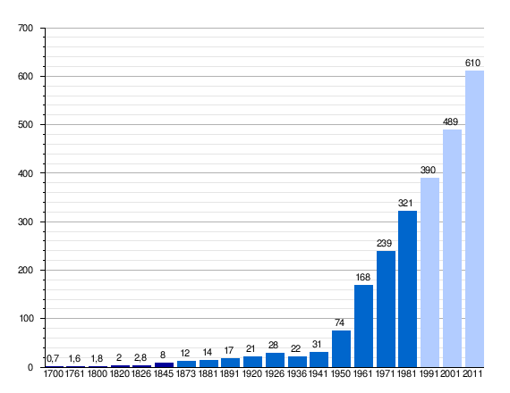 |
Colonial registrations. San Cristobal District (fragmented in 1988 in the current municipalities that make up the Greater San Cristobal). Municipality San Cristobal and metropolitan area. |
San Cristóbal is the eighth most populous city in Venezuela, the most populous in the Andean region and in the State of Táchira; With a population of 285,872 inhabitants in its urban core, it represents 22.76% of the entity's population (1,255,869 inhabitants), 17.42% of the Andean region and 0.91% of the national, which amounts to 31,431,164 inhabitants. Its metropolitan area amounts to 650,512 inhabitants, which includes the adjacent municipalities of Andrés Bello, Cárdenas, Córdoba-Guásimos, Junin, Libertad, Independencia and Torbes; which serve to a greater extent as dormitory cities of the tachirense capital.
Family situation and housing
According to the 2011 census, there are 72,194 families in San Cristóbal and there are 27,789 women heads of households (38.49%). The number of children for each woman of reproductive age is 1.8. There are some 77,331 units, of which 69,244 are occupied, 1,685 are occasionally inhabited and the rest are unoccupied or under construction. Likewise, 10.67% of the homes built are villas, 62.81% houses, 22.09% correspond to apartments (including those that are part of a house or house/villa) and 4.28% are ranches, shelters or other types of precarious housing. 47.11% of households have Internet access and 55.37% have at least one computer at home; the fixed telephone service has a coverage of 72.12%.
Economy


For 2010, San Cristóbal is the second city with the lowest poverty rate in Venezuela. For the year 2001, the city had a poor population index of 7.05% according to the 2001 census and according to the sources of the National Institute of Statistics.
The geographical situation of the city, point of convergence of the Colombian-Venezuelan binational transit and its proximity to the main cattle-raising area of the country (north of Táchira, southern region of Lake Maracaibo and west of the state of Barinas), have contributed with the development of banking and financial activity in San Cristóbal. In the public sector, one of the main banks, formerly known (Banfoandes), had its headquarters in San Cristóbal, while in the private sector the city also has the headquarters of a financial institution of local origin: Banco Sofitasa.
Industry in San Cristóbal is limited, mainly, to small factories in the metal, mechanical and textile sectors, as well as footwear. The most solid food company is Pasteurizadora Táchira (Pastca), the second largest cheese producer in Venezuela. In addition to Pastca, there are also small food preservation industries, including Conservas La Nona, a producer of jams and a cannery of canned vegetables. The typical sweet products of Industrias La Andina and Dulcería Extrafina are also well known.[citation required]
The city also has a lottery company such as the Táchira Lottery, which is owned by the state, and which with its popular game "Kino Táchira" has made thousands of Venezuelans millionaires.
The most important economic sectors of the city are in the area of services, mainly financial and insurance products. It also has specialized service clinics of important relevance in the country, particularly in the ophthalmological area. Several national ground passenger transportation service companies have their headquarters in the city.
One of the most influential aspects within its economy is the boost that trade has gained in recent years, due to its proximity to the Colombian-Venezuelan border, there was a large influx of Colombians, especially from the Colombian city of Cúcuta but now it's the other way around.
Transportation
San Cristóbal and its surrounding area have a mountainous orography, which makes it difficult to draw up efficient transport networks, however, the road network that makes up the city is well developed.
The center has two major road arteries known as seventh avenues (Isaías Medina Angarita avenue) and fifth (Francisco García de Hevia avenue), which form a northern axis -South that cuts the historical and commercial center of the city.
There are also large avenues that surround the urban territory, made up of Libertador and Carabobo avenues that run through the center-north, and España and 19 de Abril avenues serve the southeast and this in addition to linking the neighborhoods of Pueblo Nuevo and La Concordia. The western axis is communicated by the so-called Marginal del Torbes (Antonio José de Sucre avenue) that connects the exit to the Carretera de los Llanos (Barinas - Caracas) with the San Cristóbal - La Fría highway (Mérida -Maracaibo).
Other existing avenues in San Cristóbal are Lucio Oquendo, which connects the Central Hospital with 19 de Abril in La Concordia; Avenida Universidad, which serves the northeast part of the city; Quinimarí and Principal de Pirineos avenues, Los Agustinos avenue, Peblo Nuevo main avenue and i>Ferrero Tamayo, which connect the eastern and northern areas of the city with the so-called Fair Complex, an area where stadiums, the Plaza de Toros, agricultural, livestock and industrial exhibition centers, the velodrome and the University are located Nacional Experimental del Táchira, to the south the Rotaria avenue or Circunvalación Sur that connects the exit to the plains, the 19 de Abril avenue, and the new San Cristóbal Highway - El Corozo, which is under construction, among others.
Urban transport is configured by bus lines that connect the city center with most of the urbanizations and neighborhoods of the same as well as with the industrial zones of Paramillo, Barrancas and Puente Real, in addition to the commercial zones and the Metropolitan Area.
The proposal for a mass transportation system for San Cristóbal, of the tram type, is in the study phases. If the project is approved, it would be built by state power company CADELA and would greatly help reduce traffic in the city. The project for the construction of a railway line, part of the National Railway Project, between San Cristóbal and Maturín, connecting the city with eastern Venezuela, is also approved, another line will connect with Cúcuta, being the first railway connection between Venezuela and Colombia.
Ground transportation service lines that serve a large part of the country have their headquarters in San Cristóbal (Expresos San Cristóbal, Expresos Mérida, Expresos Los Llanos, Expresos Flamingo, Expresos Occidente, among others).
The city also has quick access to different airports.
Airports

Only one airport is located within the urban center of the city, the Paramillo Airport (IATA SCI Code), which is a small-capacity aerodrome for both military and civilian use located to the north of the city. It only serves private and charter flights in small aircraft. It is planned to install a Tachirense airline in the medium term that would have its seat at the Paramillo airport and from where flights initially departed to Maracaibo, Mérida, Falcón, Barquisimeto and in a slightly longer period to Caracas [citation required].
Other airports serving the city are:
- Santo Domingo International Airport or Buenaventura Vivas Air Base (IATA Code: STD), is the closest to San Cristobal, is about 50 km away in the Llanos Road (San Cristóbal-Barinas/Caracas), has direct connections to Caracas and connections via Caracas with any other point in the country and international flights. The companies Aserca Airlines, Rutaca, Laser Airlines and Conviasa operate from and to this airport.
- Juan Vicente Gómez de San Antonio del Táchira International Airport serves as a bridge between Colombia and Venezuela. Your IATA code is SVZ. It is 45 km from San Cristobal. This airport operates the Rutaca airline, previously operated airlines such as Aeropostal and SBA Airlines. It has direct connections with Maracaibo and Caracas and connections via Caracas with any point of the national territory and international flights.
- Francisco García de Hevia National Airport of La Fría (40 km north), the Conviasa Airlines was the one that made the flights from Caracas to this airport, but due to problems of the same airline it ceased to operate, it is expected that its flights will begin again soon.
Access routes
San Cristóbal can be reached by the following land routes (note= shortest route):
- From Caracas : Regional Autopista del Centro to Valencia, following to San Carlos and Acarigua, from this point by the Autopista José Antonio Páez to Barinas and from this point by the Via to the Llanos (816 km).
- From Merida : Autopista hasta El Vigía from this point by the Pan American Highway through Coloncito, La Fría and San Juan de Colón (167 km).
- From Maracaibo : Machiques Road Colon to La Fría, from this point on the Pan American Highway (437 km).
- From Cúcuta : Pan American Highway via Cúcuta - San Antonio del Táchira - Peracal - Capacho - San Cristobal (57 km from Cúcuta).
- Carretera Trasandina , initially it was the main route to reach San Cristobal from Mérida, currently links several towns and cities and is a tourist route.
Education, Customs and Art

University Education
The city is the headquarters of different public and private university study houses.
Public universities
It has a state-owned academic center such as:
- Táchira National Experimental University (UNET)
Also having nuclei of the following university education centers:
- University of Los Andes, Táchira core (ULA)
- Instituto Universitario de Tecnología, Región de los Andes (IUT)
- Open National University (UNA)
- National Polytechnic Experimental University of the National Armed Forces (UNEFA)
- Bolivarian University of Venezuela Nucleo Táchira
- Instituto Militar Universitario, de la Guardia Nacional Cnel (F) Aniceto Cubillan Jaimes
Private universities
- Catholic University of Táchira (UCAT)
- Instituto Universitario de Tecnología Juan Pablo Pérez Alfonzo (IUTEPAL)
- University Institute of the Border (IUFRONT)
- University Institute of Specialized Education (IUNE)
- Instituto Universitario Tecnológico Industrial (IUTI)
- Instituto Universitario Gran Colombia (IUGC)
- Instituto Universitario Politécnico Santiago Mariño
- Instituto Universitario de Tecnología Antonio José de Sucre
- Colegio Universitario Monseñor de Talavera
- Instituto Universitario Jesús Enrique Losada
- Caribbean International University
- Instituto Universitario Eclesiástico Santo Tomás de Aquino (IUESTA)
Customs
Local festivals
The city's main festival is the San Sebastián International Fair, a series of jubilant events held in San Cristóbal, Táchira state, during the second half of January in honor of the city's patron saint, San Sebastián. In the seasons of carnival, Easter, the anniversary of the city, and Christmas, different cultural and recreational activities are carried out for the enjoyment of the people of San Cristobal.
Gastronomy
Traditionally receiving external influences (Colombian, Italian, Spanish, Mexican, Portuguese and to a lesser extent German and Arab immigration) the gastronomy of San Cristóbal is a collage of indigenous Andean dishes (pisca andina, wheat arepas, corn buns, cabbage indiecitos) with regional variations of foreign dishes (tripe or Andean mute, tripe with chickpeas, and grills).
The richness of San Cristobal's gastronomy is not limited to the flavors of home cooking, but it is one of the places in Venezuela where it is easier to find food on the street, sometimes in improvised tarantines and cauldrons, where you can find typical dishes such as: black pudding on Avenida Carabobo or in the Santa Teresa urbanization, Andean cakes (meat with rice, chicken or cheese with a guava sandwich) in Pueblo Nuevo or Barrio Obrero, Andean chicha and masato or a delicious typical drink called Bomba that can be found in the Small Merchants Market of La Concordia, are common in many typical and traditional food places.
Art
There are various schools and art academies in San Cristóbal, both public and private:
Some Public Institutions:
- Music School "Miguel Angel Espinel": Located in the Guacara, forming several national and international talents.
- Escuela de Artes Plastics "Valentín Hernández": Located in the Sector la Guayana
- Regional Theatre School.
- National Dance School (ENDANZA): Located by the Torbes Urbanization, this is the oldest in the country
- Fundación Musical Simón Bolívar.
- Orquesta Sinfónica “Simón Bolívar” del Táchira.
Some Private Institutions:
- Pen and Lira Academy: Located in the Center.
- Date music: Located in Barrio Obrero.
- Flamenco Academy "Andreine Silva" Located in Pueblo Nuevo.
- Fundación Coral del Táchira FUNCOTA: Located in the Acacias, a foundation that has a long history in the Venezuelan coral movement. Ente governed by the Coral del Táchira, an institution declared Cultural Heritage of the State Táchira and Cultural Heritage of the Nation.
- FUNTAC (Coro Cultural Foundation of the Chamber of Tachira). Head of the Chamber Choir of the Táchira and Coro de la Opera del Táchira.
It also has several cultural organizations dependent on the intense university activity in the city and one of the most recognized artistic photography movements in the country.
The city also has one of the first regional television channels in the country, Buena TV, which dedicates most of its airtime to broadcasting cultural and educational programs.
In 2006, the National Experimental University of Táchira responded to one of the needs that had affected the population for a long time, especially musicians, since it opened the Bachelor of Music; satisfying a great lack that directly impacted the essence of San Cristobalense, the artistic essence of the region; and also has this house of studies, the Architecture Career.
The bambuco and the Andean waltzes are the traditional musical movements of San Cristóbal. Pieces like Tierra Tachirense (considered by some as a second state anthem), Andinita (by composer Chucho Corrales) and Brisas del Torbes (by Luis Felipe Ramón y Rivera) are representative of these musical expressions.
Museums
- Táchira Anthropological Museum: The Táchira Museum operates since 1984 in the spaces of the Hacienda Paramillo. It has 10 rooms, between exhibition rooms and recreational areas. It has an extensive library specialized in anthropology, archaeology, history and folklore.
- Museo de Artes Visuales y del Espacio (MAVET), a space located in the Casona 25, declared a good heritage of the country.

Places of interest
In San Cristóbal there are several places of significant importance for the region, both historically and economically.
However, it is through direct contact with the people of the city that you get to discover the best places of interest because the city is rich in places with picturesque names and anecdotes. Places like the Piedra del Jurungo, of the Loma del Viento (in the Chorro El Indio National Park) or La Cueva del Oso (Paramillo). They owe their name to the imagination and folklore of the people of San Cristobal. In the so-called Barrio Obrero are the largest number of discos and night spots in the city.
Since 2006, a shopping center belonging to the Sambil chain has been in operation on the Antonio José de Sucre highway.
45 min from the city in a northerly direction is El Páramo del Zumbador, a place of great tourist interest with a height of 2,520 m s. no. m., in the same direction are located the agricultural towns of El Cobre and La Grita successively with beautiful landscapes and rich in flora typical of the region.
City spaces
There are numerous public spaces of interest in San Cristóbal that contemplate architectural works of various tendencies, it is worth mentioning the Civic Center, a set of towers for commerce and offices of public and private entities located on seventh avenue; the Ateneo del Táchira, an old cultural center designed by Luis Chataing; the Cathedral of San Cristóbal, the Episcopal Palace, the Palace of Los Leones, the National Building, the Táchira Museum, the Libertador Bridge, the Fair Complex, the Monumental Plaza de Toros de Pueblo Nuevo, numerous Catholic temples of different architectural trends, the Neighborhood Unit, the first urbanization of social interest in the city; Plaza Los Mangos, in the center of Barrio Obrero, among many others.
Religious buildings
The Cathedral of San Cristóbal is a colonial-style temple. It was erected during the 18th century and is widely visited by tourists and visitors, due to the fact that it preserves pictorial and sculptural works of relevant artistic and historical value in its internal areas.
The space is oriented to the veneration of the images of San Cristóbal, El Cristo del Limoncito and San Sebastián, patron saint of the city. Initially this church was a hermitage, which had to be remodeled on different occasions, as a result of two earthquakes. It is located on Calle 5 with Carrera 3.
Located right next to the Cathedral of San Cristóbal is the Episcopal Palace, a neocolonial-style construction that serves as the seat of ecclesiastical power in the Tachirense region. It offers in its spaces a permanent exhibition, where relics and articles from the colonial era stand out.
The population of San Cristobal is mainly Catholic, however Evangelical, Pentecostal, and other Christian Protestant communities also have temples in the city.
Some of the ecclesiastical architectural works of the city stand out:
- Church of La Ermita.
- Our Lady of the Rosary Church (La Concordia).
- Corpus Christi Church.
- Cathedral Church.
- Church of the Divine Redeemer.
- Church of St. John the Baptist.
- Sanctuary of Our Lady of Perpetual Help.
- Church of Our Lady of Coromoto.
- Church of San José, in the center of the city, of neogothic architecture.
There are also churches of different Christian denominations in San Cristóbal, among which we can highlight:
- Cuadrangular Church in La Concordia
- Cuadrangular Church in Puente Real
- Cuadrangular Church in the Ferrero Tamayo
- Quadrangular Christian Center
- Christian Center San Cristobal "La Carpa"
- Maranatha Táchira Church
- First Baptist Church of Saint Christopher
- Seventh-day Adventist Church in Workers’ District Adventist Building
- Evangelical Christian Church Gethsemane
- Temple Light and Life
- Venezuelan Christian Celebration Church in Concordia
- Tabernacle of New Jerusalem (Sector Venezuela)
- Christian Church World Mission Movement.
- Church of Unification (The Association of the Holy Spirit for the Unification of World Christianity) (AESUCM)
Parks, squares and walkways
- Monument La Marina LighthouseAutopista Antonio José de Sucre.
- Plaza María del Carmen Ramírez (Los Mangos) ‘‘‘, 12th Street between 20 and 21, Workers’ Quarter.
- Plaza Ríos Reina (Los Enanitos) ‘‘, Fifth Avenue, former Hospital Vargas.
- Park ExhibitionASOGATA, New Town.
- Metropolitan ParkApril 19th Avenue.
- Parque La RomeritaCarabobo Avenue.
- Parque El EjércitoCarabobo Avenue.
- Plaza BolívarSeventh Avenue.
- Parque La ParadaLa Popita.
- Garbiras Park15th Street.
Monuments, public buildings and historical places

- Velódromo J. J. Mora ‘‘(Avenida Universidad, Pueblo Nuevo), headquarters of the 1977 World Cycling, rehabilitated in 2005.
- Civic Center of San CristobalSeventh Avenue, built in the 1980s, trade center and headquarters of several public and private service companies.
- Hotel El TamáApril 19th Avenue. Built during the government of Marcos Pérez Jiménez.
- Hospital Central, Avenida Lucio Oquendo, La Concordia, the largest medical care center in the state, carried out during the government of Marcos Pérez Jiménez.
- Casa Sindical, Avenida Libertador, Las Lomas; Fetratáchira headquarters, regional trade union agency, has convention rooms and a theatre. Built during the government of Marcos Pérez Jiménez.
- Obelisk of the Italian Colony, Avenida 19 de Abril, erected in tribute to the Genoese Christopher Columbus
- Estadio Polideportivo de Pueblo Nuevo ‘‘remodelado para la Copa América.
- Stadium J. J. Mora, Fair Complex Area (New Town)
- Fair Complex (Pavilions of Exhibition Colombia and Venezuela) at Avenida España, Pueblo Nuevo, set of structures where most of the activities of the International Fair of San Sebastián are carried out
- Sports Complex Formed by a group of several sports structures (Olympic gymnastics, basketball, soccer room, volleyball, halterophilia, basketball, etc.) Built during the regional government of Ronald Blanco La Cruz.
- Monumental Bullring ‘‘’
- House Steinvorth, commercial seat of coffee trade, built in the centuryXIX and reconstructed during the regional government of Ronald Blanco La Cruz with the support of Banfoandes currently Bicentenario Banco Universal.
- Gymnasium Armino Gutiérrez Castro, La Concordia; first headquarters of a professional basketball team in the city, remodeled during the regional government of Ronald Blanco La Cruz.
State Powers and Culture
The powers and institutions of the state are located in various precincts of the city, some of recent data, such as the Civic Center, and others in structures from the end of the century XIX or early XX century. The Reading Room of the Ateneo del Táchira, located in the center of the city, and the work of the architect Luis Chataing, dates from the beginning of the XX century. .
Los Leones Palace and National Building
During the 1920s, under the government of Juan Vicente Gómez, the Palacio de Los Leones was built, which owes its name to the two lions that crown its structure. It was declared a National Historic Monument and in the Today it serves as the seat of the regional government. It is located on Calle 5 with Carrera 10.
The National Building of San Cristóbal, located on Calle 5 between Carreras 2 and 3, is currently the headquarters of the region's civil courts. It was built during the government of Cipriano Castro, then serving as a fort and later as a prison during the period of Juan Vicente Gómez. Later, under the Marcos Pérez Jiménez regime, it served as the headquarters of National Security and today preserves both like the characteristic style of the 1950s.
Libertador Bridge
The Libertador Bridge dates from the Juan Vicente Gómez government period, and its iron structure actively facilitated land communication between the city of San Cristóbal and the lands located to the west bank of the Torbes River (mainly Táriba), until the construction of Antonio José de Sucre avenue (popularly known as Marginal del Torbes), which currently communicates San Cristóbal with the Cárdenas and Guásimos municipalities (Táriba, Barrancas, Tucapé, Patiecitos and Palmira). It is the work of the Eiffel company and is currently preserved as a monument
Entertainment and tourism

As the city is home to more than a dozen university centers, San Cristóbal is a city with a lively nightlife, the liberality and spontaneity of the people of San Cristóbal being known when it comes to choosing their place of playful entertainment, which does not exclude public places such as the parking lot of the Plaza de Toros and various viewpoints. Numerous nightclubs, bars, taverns, discos and clubs are scattered throughout the urban area and it is easy to find one of these places open any night of the week.
It is also possible to do ecological tourism in the Chorro El Indio National Park, 5 minutes from the city.
However, soccer is the most recognized source of mass entertainment for the city, which in its recent history has had three champion clubs in the national tournament; Deportivo Táchira and the missing Atlético San Cristóbal and Nacional Táchira.
The hotel infrastructure underwent a renovation process to provide greater comfort to visitors, this as a result of several 2007 Copa América matches having been held in the city.


The State of Táchira has different tourist attractions, among which stand out the walks of the mountain routes and the páramo (El Zumbador, Los Rosales, La Negra, El Tamá), the cattle areas of the road to the plain and the South del Lago (from Maracaibo), the Pan-American route, the traditional and customary towns (Peribeca, San Pedro del Río, El Cobre, Pregonero), the architecture of San Cristóbal, La Grita, the numerous restaurants serving typical Andean food, sporting events held in the city of San Cristóbal (mainly the matches of Deportivo Táchira, of the Venezuelan First Division League), the patron saint fairs and festivals, mainly the San Sebastián International Fair, among many others.
Táchira is also the center of fluvial sports activities, such as sport fishing (developed in the numerous fluvial courses of the State, mainly in the Uribante, Caparo and Doradas rivers), some activities such as canoeing and other specialties are developed in the artificial lake formed by the Uribante-Caparo dam, from the hydroelectric complex of the same name.
The sites of greatest interest, both tourist and historical, are represented by some buildings of architectural value, which are closely linked with the Tachirenses due to the activities that are developed there, such as public buildings, religious centers, centers shows and sports.
The Ateneo del Táchira is the oldest in Venezuela, apart from being the first cultural center erected in the aforementioned entity. Its foundation was carried out on April 19, 1907, although the construction that it looks like today was started in 1935. It is located on Calle 9 with Carrera 6.

Legend and myth
This popular entity has a peculiar way of seeing existence, which is why next to the erudite logic of the enlightened classes is the other side of magical illogicality, overwhelming fantasy, the irrationality of the dreams of a large sector of the population when they communicate their literary orality. Another way, finally, to explain the world, things, life. Now, this feature of Venezuelan ethnicity, this fantastic literature would be lost in oblivion, or in silence, if there were no transcribers from orality to writing, and in Táchira (Venezuela), the person who has demonstrated suitability in this task her name is Lolita Robles de Mora.
Media
Print media
The newspapers in San Cristóbal are Diario Católico and Diario La Nación. In addition to those mentioned, there is the Diario de los Andes, originally from Trujillo state, which has its own editorial and print run for San Cristóbal.
Television
There are open-signal regional television channels:
- Táchira Regional Televisor (TRT), the oldest.
- Táchira Cultural Television (TVCT), an open-signed television station in the metropolitan area of the city.
- Channel 21, News-focused channel operates through private signal (by cable).
- Telemax (Alternative Television) It is a local cable television channel that offers programming focused on youth and adult society.
There are also other channels in the city that operate through a private signal (by cable).
Radius
San Cristóbal was the scene of the first radio receptions in the state of Táchira around the year 1926, it was also the place where the first radio transmitter in the region was established in 1933. La Voz del Táchira (founded in 1935) has operated uninterruptedly under 3 different names to this day and together with Ecos del Torbes (1947) are the most representative amplitude modulated stations in the city. Both stations belong to the Grupo Radial González Lovera.
FM radio began its development with the appearance of 102.1 Stereo (currently La Mega 102.1 FM) in 1989, quickly making San Cristóbal the second city in terms of radio stations in the country and the one with the largest number of radio stations per inhabitant, with more than thirty FM stations in the metropolitan area.
Sports
There are several sports clubs in different specialties, being the one with the highest honors Deportivo Táchira F.C., a multi-champion team of rented soccer in Venezuela.
Other professional clubs:
- Deportivo Táchira Futsal (Sale football)
- Deportivo Táchira (baloncesto) (Baloncesto)
During 2005, the National Sports Games of Venezuela Andes 2005 were held in the states of Táchira, Mérida and Trujillo, with San Cristóbal being the host city for the largest number of sporting events. This required the construction of several sports works in the city such as the San Cristóbal Baseball Metropolitano Stadium, as well as the remodeling of other areas such as the Arminio Gutiérrez Indoor Gymnasium.
In 2006, the Pueblo Nuevo Polideportivo stadium was remodeled and expanded its capacity, which went from having a capacity of 42,000 spectators, serving as the venue for the Venezuelan national team in the 2007 Copa América.
In 2007 with the Expansion of the Professional Basketball League of Venezuela, the Local Deportivo Táchira team was admitted as one of the 2 new members of the league that reaches 10 teams, formally beginning its participation in March 2008.
Sister cities
 San Cristóbal de Las Casas, Mexico
 St. Petersburg, Russia
 Edmonton, Canada
 Cúcuta, Colombia
 Reguengos de Monsaraz, Portugal
 Valladolid, Spain
- Pasto, Colombia
 Omaha, United States
 Marseille, France
 Mérida, Venezuela
- Envigado, Colombia
 Рita, Japan