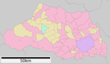
Saitama Prefecture
The Saitama Prefecture (埼玉県, Saitama-ken? ) is located on the island of Honshū, Japan. The capital is the city of Saitama.
History
Saitama Prefecture is located north of Tokyo, the Japanese capital. A third of its land is mountainous, and the rest of the plain, being a region where agricultural and forest activity predominated. After the Second World War, Saitama prefecture experienced transformations caused by industrial development and population growth. In the cities of Omiya (now the city of Saitama), Fukaya, Kawagoe and Sayama were built large industrial centers, and the Prefecture changed its main activity, from agriculture to the mechanical industry.
The proximity to Tokyo also produced rapid growth in residential areas. Of the 2.14 million inhabitants in 1950, the population tripled to 7 million in 2002.
To cope with social and economic developments, the Saitama Government together with the 90 prefectural municipalities have instituted comprehensive policies, based on "environmental priority" and the "importance of the quality of life of population".
Geography
Saitama Prefecture borders Tokyo and Chiba Prefectures to the south, Ibaraki and Tochigi to the east, Gunma to the north, Nagano to the west, and Yamanashi to the southwest. It is located in the west-central part of the Kanto region, stretching for 103 km from east to west and 52 km from north to south. At 3,797 km², it ranks as the ninth smallest prefecture. The eastern border with Chiba Prefecture is defined by the Edo River. The northern and northwestern border lines with Gunma Prefecture are marked by the Tone River and the Kanagawa River and water divisions by the Arakawa River and Kanagawa River. The southwestern border is defined by the watershed of the Arakawa River, Tama River, and Fuefuki River. The eastern part of the southern boundary line, however, does coincide with any geological features.
The topography of Saitama Prefecture is largely divided by the Hachiōji tectonic line, which runs through Kodama, Ogawa, and Hannō, into the western highlands and eastern lowlands. The height, highest on the western side, gradually decreases to the east from the hilly areas through the plateaus and from there to the lowlands. The eastern lowlands and plateaus occupy 67.3% of the area.
The eastern side, part of the Kanto plain, can be divided into nine separate stretches of hills and ten plateaus. The former occupy small areas close to the Kanto mountains, such as the Hiki and Sayama hills. The latter are mainly surrounded by alluvial floodplains. In the southeastern part of the prefecture, the Ōmiya Plateau lies in a southeasterly direction, bounded by the Furutone River to the east and the Arakawa River to the west.
The western side of the prefecture belongs to the Kanto Mountain Range with the Chichibu Basin located at its center. The area to the west of the basin features high peaks such as Mount Sanpo (2,483 m) and Mount Kobushi (2,475 m), where the Arakawa River has its source. Most of the land is within the Chichibu Tama Kai National Park. The area to the east of the basin is made up of relatively low mountains.
Cities (Urban Districts)
|
|
|
Districts (Rurales, with its municipalities and towns)
|
|
|
|
Contenido relacionado
Jerusalem
The cabaco
Vergina


