
Saint Louis Province
San Luis, in the text of the provincial Constitution: Province of San Luis, is one of the twenty-three provinces that make up the Argentine Republic. In turn, it is one of the twenty-four self-governing states or first-order jurisdictions that make up the country, and one of the twenty-four national legislative electoral districts. Its capital and most populous city is the homonymous San Luis. It is located to the southeast of the Nuevo Cuyo region, to the west of the country, bordering to the north with La Rioja, to the east with Córdoba, to the southeast and south with the Province of La Pampa, to the west with the Desaguadero river that separates it from Mendoza., and to the northwest with San Juan. With 502,003 inhab. in 2020, it is the sixth least populated first-order jurisdiction — ahead of Catamarca, La Rioja, La Pampa Province, Santa Cruz and Tierra del Fuego Antarctica and islands of the South Atlantic, the least populated—, and with 76,748 km² the sixth least extensive jurisdiction of first order—before Formosa, Jujuy, Misiones, Tucumán and the Autonomous City of Buenos Aires (CABA). (the least extensive), and with 6.54 inhabitants/km², the seventh least densely populated, ahead of La Rioja, Catamarca, Río Negro, Chubut, the Province of La Pampa and Santa Cruz, the least densely populated.
History
San Luis was inhabited before the arrival of the Spanish in the XVI century by various indigenous ethnic groups: sedentary such as the group of the "comechingones" that took over the entire mountainous region, huarpes of the huanacache group in the marsh basin to which they gave their name Guanacache or perhaps some Diaguitas of the olongasta group in the far north and transhumants such as het of the great Taluhet partiality in the plains of the «Travesía Puntana» (western sector of the Pampas region).
In the 18th century the ethnic scene had changed drastically after the arrival of Europe. The sedentary ethnic groups had mixed and acculturated, becoming almost completely Creole, while the taluhet decimated by the plagues were replaced or acculturated by Mapuchized groups such as the Pehuenche (former Huarpes from southern Mendoza and northern Neuquén) and - mainly- the Ranqueles - mixogenic group of hets, guenenakuna or "patagones" northern, Pehuenche and Mapuche in which the dialectized Mapuche language predominated as well as various other cultural traits -belief system for example- also of Mapuche origin, in the same way, in the extreme south of the province were the Puelches -Guenenakuna or Patagones northerners highly acculturated by the Mapuches.
Although its founding document has been lost, it is believed that the city of San Luis was founded on August 25, 1594 by Luis Jufré de Loaysa y Meneses, lieutenant corregidor of Cuyo. The region was part of the Corregimiento de Cuyo with head in the city of Mendoza integrating the General Captaincy of Chile dependent on the Viceroyalty of Peru.
In 1596, after having been abandoned, Martín García Oñez de Loyola, Captain General of Chile, ordered the founding of it again. The city then received the name "San Luis de Loyola Nueva Medina de Río Seco".
In 1643 the city was transferred to the area of "El Talar". In 1689 a new transfer took place, placing the city in its current location.
In 1776 the Corregimiento de Cuyo was incorporated into the new Viceroyalty of Río de la Plata.
The Royal Ordinance of Mayors of January 28, 1782 divided the Viceroyalty of the Río de la Plata into 8 governorships-intendances, in addition to the military and political governorships of Montevideo and the towns of the old Jesuit missions, briefly forming the Municipality of Cuyo, of which San Luis formed part as a party.
But as a consequence of the report presented by Viceroy Juan José de Vértiz y Salcedo, this structure was modified by Royal Order of July 29, 1782 and by the clarifying document of August 5, 1785, suppressing the municipalities of Cuyo and Santa Cruz de la Sierra and dividing that of Tucumán, integrating Cuyo the new Governor's Office of Córdoba del Tucumán.
On June 14, 1810, the Cabildo de San Luis recognized the new government of Buenos Aires and on June 28, appointed Marcelino Poblet deputy to the Junta Grande.
In August 1812, a census ordered by the central authority was completed in order to find out the number of men of military age.
The census classification indicated the permanence of a class-type social stratification system. The population was classified as: Spanish, black, Indian, brown, American white.
On November 29, 1813, the Intendency of Cuyo Governorate was recreated, separating it from that of Córdoba del Tucumán, integrated by the parties under the command of sub-delegates from San Luis, Mendoza and San Juan. The first lieutenant governor assigned to Cuyo was Colonel Florencio Terrada, later, Colonel Marcos Balcarce and then José de San Martín were appointed Mayor Governor. The Intendancy of Cuyo had the city of Mendoza as its capital.
On March 27, 1814, Vicente Dupuy took office as lieutenant governor, reporting to the resident mayor governor in Mendoza.
After the fall of the Directory as a result of the Battle of Cepeda was known in San Luis, on February 15, 1820 an open council met that deposed the lieutenant governor Dupuy, the mayors of 1st and 2nd vote and a councilor, and the government temporarily passed to the town hall until the inhabitants of the countryside could arrive to participate in the election of a new town hall. The province thus proclaimed its administrative autonomy from the government of Cuyo. On February 26, an open council met that re-elected the same members of the council chaired by Tomas Varas as mayor with 1st vote, assuming the title of Governing Council:
First, that after thinking with mature examination and scrupulousness, in the subjects in which he had to deposit his rights in the administration of command, a president is named before the one who squeezed his suffrages, which was resolved was I. Interim governor, whose zeal for the freedom of the country, were satisfied. Second, that the government is composed of the City Council, and therefore, that in it they are only consolidated, or the powers of understanding in the four cases, or causes, namely: political, military, finance and war, for which reason their title will be of Cabildo-Gobernador. Thirdly, that the City Council has the power to convene the body of officers and with them to choose and appoint a Commander of Arms, in a subject covered by the circumstances relating to that ministry and its approval.Part of the record of 26 February 1820
 Wikisource contains original works of or about San Luis Province.
On March 1, the Governor's Council was installed, which sent a communication to the governor of Buenos Aires referring to what happened. That same day, representatives of San Juan and Mendoza signed an act that recognized San Juan's autonomy and in fact dissolved the Governor's Office of Cuyo. On March 23, 1820, José Santos Ortiz was appointed mayor with the first vote, replacing Varas (or Baras).
On January 23, 1821, Ortiz assumed the position of Mayor of San Luis.
On August 22, 1822, the Pact of San Miguel de las Lagunas was signed between the governors of the three provinces of Cuyo, with the unfulfilled objective of reestablishing the Province of Cuyo: forming a central authority representative of all the peoples of the union dictated by the constitution that should govern them.
On January 7, 1832, a Provisional Statute was issued for the province.
In 1855, Governor Justo Daract swore in the new provincial Constitution.
On May 20, 1881, an interprovincial boundary treaty was signed between San Luis and Córdoba, but on October 18 of that year it was disapproved by the provincial Legislature, which on September 25, 1882 approved to submit the quarrel. The limits with the Province of Córdoba were defined by agreement on June 28, 1896.
On February 3, 1881, an interprovincial treaty was signed with the Province of La Rioja, defining the limits between the two, which was approved by the provincial Legislature on June 30, 1882.
The boundary with the Province of La Rioja was established by the so-called National Law No. 22184 issued by the military government and published in the Official Gazette on March 12, 1980.
Administrative division

NOTE: The Department of Capital from 2010 begins to bear the name of Department Juan Martín de Pueyrredón.
For a complete list of the municipalities in the province, see Annex: Municipalities and municipal commissions of San Luis. For information on the provincial municipal organization, see Municipal Organization of San Luis. For information on the 2010 census by department, see Annex: Departments of the province of San Luis by population (2010). The following is the list of the departments with their head town.
- Department Ayacucho (San Francisco del Monte de Oro)
- Belgrano Department (Villa General Roca)
- Department Chacabuco (Concaran)
- Department Colonel Pringles (La Toma)
- Department General Pedernera (Villa Mercedes)
- Department of Governor Dupuy (Good Hope)
- Department Junín (Santa Rosa de Conlara)
- Department Juan Martín de Pueyrredón (San Luis)
- Department Libertador General San Martín (San Martín)
| Department | Population | Surface | Density
(hab/km2) |
|---|---|---|---|
| Ayacucho | 18 927 | 9 681 | 1,95 |
| Belgrano | 3 945 | 6 626 | 0.59 |
| Chacabuco | 20 644 | 2 651 | 7.78 |
| Colonel Pringles | 13 082 | 4 484 | 2.91 |
| General Pedernera | 125 470 | 15 057 | 8,33 |
| Governor Dupuy | 11 532 | 19 632 | 0,58 |
| Juan Martín de Pueyrredon | 204 512 | 13 120 | 15,58 |
| Junín | 28 808 | 2 476 | 11,63 |
| Liberator General San Martín | 4 668 | 3 021 | 1.54 |
| San Luis | 432 310 | 76 748 | 5,63 |
Population

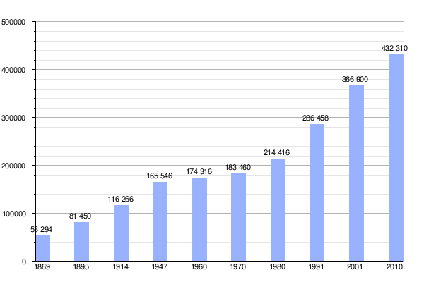
Historical evolution of the province:
- 1778: 6,956 hab.
- 1815: 17,000 hectares.
- 1820: 20,000-25,000.
- 1847: 20,000 hectares.
- 1853: 30,000 hectares.
- 1869: 53.294 hab.
- 1895: 81,450 hab.
- 1914: 116,266 hab.
- 1947: 165,546 hab.
- 1960: 174.316 hab.
- 1970: 183,460 hab.
Current provincial population:
- 1980 census: 214,416 inhabitants (Indec, 1980)
- Census 1991: 286,458 inhabitants (Indec, 1991) (urban population 232,400 (Indec, 1991)), (rural population:54,058 (Indec, 1991).
- Census 2001: 366,900 inhabitants (Indec, 2001) (urban population:320,006 (Indec, 2001), rural population:46,894 inhabitants (Indec, 2001).
- National census 2010: 432,310 inhabitants (urban population: 383,340 (Indec, 2010), rural population: 48,970 (Indec, 2010)).
| Graphic of demographic evolution of San Luis between 1869 and |
 |
Geography


It presents two well-differentiated environments: in the northern half, the mountainous landscape predominates, coinciding with the Sierras Pampeanas, and in the southern half, the flat relief.
The mountains are grouped into 3 chains that run from north to south, separated from each other by large flat valleys. From east to west, the 1st chain includes the Comechingones mountain range that forms the border with Córdoba (in this range is the maximum height of the province, the Cerro de las Ovejas, 2,297 m.a.s.l., which is accessed from Villa de Merlo), and the Tilisarao and Estanzuela mountains, both in the Conlara Valley, which separates them from the 2nd group, the San Luis Mountains. In this cordon there are hills of volcanic origin such as Cerro Sololasta, Cerro Tomolasta and Cerro Inti Huasi.
Finally to the west there is a 3rd group of highly eroded mountain ranges made up of several ranges: the Guayaguas, Cantanal, de las Quijadas, Alto Pencoso, del Gigante and Cerrillada de la Cabra mountain ranges. Between this group of mountains and those of San Luis, a relative depression is formed, occupied by the Pampa de las Salinas in its northern end and by the Salina del Bebedero in its southern part.
The southern half of the province is characterized by its flat landscape, bordered by the Pampean plain to the east, with hard grasses and a large number of lagoons where the groundwater table emerges; and with the Cuyana crossings to the west, where the bushy steppe and Caldén groves with areas of dunes and almost no water predominate.
In the plain there are also some isolated mountains such as the El Morro volcanic group, an island hill located where the Conlara Valley merges with the Pampean plain; the Yulto mountain range, to the south of it; and the Sierras del Tala and Varela, an extension of the Sierras de San Luis.
Climate
.svg)
In general it is dry continental with an average annual temperature of 17 °C, winter average of 8 °C and summer of 24 °C. The rains decrease from east to west and occur mainly in summer, between the months of October and March. In winter they are almost nil and can precipitate in the form of snow at any height but especially in the mountains above 1000 m s. no. m..
In the mountain area, the biome is arid with mountains and fields, although the temperate mountain biome develops on the eastern slopes of the mountains, more humid than the previous one, since the slopes of the mountains behave as a condensation front for the Atlantic wind.
In the Conlara Valley area there is a very special microclimate, characterized by the high natural negative ionization of the air, with a high ozone content with very beneficial effects on health.
Water resources
In the area of the mountains, a large number of streams are born that feed the Conlara and Quinto rivers, these are endorheic in nature as they are absorbed by the earth as they advance through the sedimentary plain. Only the Quinto manages to drain into the Salado River in times of great flooding.
Several of these rivers and streams are used with reservoirs to generate hydroelectric power, regulate their flows and generate water for irrigation and human consumption, however, it is a province in which several localities are affected by the droughts that occur in several months of the year for which extreme caution must be exercised in the use of water, many times they are in "Water Emergency" which does not allow the waste of water but is prioritized for personal use.

Main levees of San Luis
| Name | Surface | Capacity | Deep | Opening |
|---|---|---|---|---|
| Embalse La Florida | 650 ha | 105 hm3 | 37 m | 1953 |
| Potrero de los Funes | 91 ha | 6.80 hm3 | 33 m | 1927 |
| Dique La Huertita | 430 ha | 47.00 hm3 | 1981 | |
| Dique Nogolí | 170 ha | 25.80 hm3 | 50 m | 2003 |
| Dique Paso de las Carretas | 75 ha | 105.00 hm3 | 40 m | 1982 |
| Dique Villa General Roca | 1.70 hm3 | 1956 | ||
| Dique Cruz de Piedra | 154 ha | 12.50 hm3 | 29 m | 1941 |
| Dique San Felipe | 1200 ha | 81 hm3 | 1941 | |
| Dique Antonio Esteban Agüero | 107 ha | 19.30 hm3 | 60 m | 2001 |
| Dique Luján | 27 ha | 3.60 hm3 | 37 m | 1958 |
| Dique Las Palmeras | 186 ha | 24.00 hm3 | 50.8 m | 2010 |
| Dique Saladillo | 296 ha | 50 hm3 | 79 m | 2011 |
| Dique La Sepultura / Piscu Yaco | 17 ha | 1 hm3 | 30 m | 2010 |
| Dique Leveler Vulpiani | 1909 | |||
| Dique Leveler Chico | 1887 | |||
| Dique Boca del Río | 138 ha | 8.54 hm3 | 35 m | 2012 |
| Dique Paso Grande | bidding | |||
| Dique Quines | bidding | |||
| Dique La Estrechura | 50.1 ha | 2.61 hm3 | 21 m | 2013 |
| Dique Berta Vidal de Battini | 16 ha | 20 hm3 | 42 m | 2012 |
| Source: San Luis Agua State Society | ||||
The western limit of the province is Desaguadero -also called Salado, -which forms a complex system (Desaguadero System) that, since the second half of s XIX and especially throughout the entire century XX has suffered a serious reduction in water flows with the consequent almost disappearance of the Guanacache Lagoons (on the borders of San Luis, Mendoza and San Juan) and the transformation of the El Bebedero Lagoon into a saline and the drying up of the homonymous river.
Wildlife
Despite the aridity of the geography of San Luis, the faunal catalog is not extremely abundant.
Among the best-known mammals in the area we find pumas, wild cats, gray foxes, vizcachas, collared peccaries, guanacos and the last deer of the pampas (along with those of Samborombón Bay and Campos del Tuyú National Park in Buenos Aires). The Patagonian mara or hare and the rabbit of the sticks can also be seen. The deer (Ozotoceros bezoarticus), was very abundant in other times, today it is scarce, which is why it is essential to carry out the Los Venados National Park Project, which aims to preserve both the species that gives it its name and the last remnant of grasslands. unplowed from the dry pampas.
In the province, birds exist in a great variety and abundance of species of all sizes and colors in which the most characteristic of the area are the Teros, the yellow and Common Cardinal, the Great Moorish Queen, the King of the Forest and catitas of the mountains, parrots, among others. Also pepiteros, monteritas and a great variety of small birds. The list of birds is completed with the ñandú, the gray falcon, the Eagles, the goldfinch, the thrush, the Calandrias, the hornero, the Andean condor, among the most famous in the central zone.
Amphibians are very rare and spend the dry season buried or in the form of tadpoles, in small pools protected from the sun. Lizards are the most common reptiles. And the vizcacheras boa is sought after for its beautiful fur, even though it is already rare and threatened. There are numerous aquatic birds, among which the common flamingo stands out. Silverside, trout or Creole perch and European carp are also present in the water bodies, the latter was introduced into reservoirs and tributaries in the area.
Native flora
The Province of San Luis preserves three well-defined zones: the mountains, the western Chaco, and between the two, a wide transition strip, with extensive plains.
In the mountains we find extensive jarillares and broom, which cover the most arid areas. On the pasture of the aguada there is a curious tree that shows a tortuous aspect, it is the girl, an endemic species of the mountain. Other endemic species are the solo, which has the shape of a whitish circular cushion, the purslane, with a striking intense green color and fleshy leaves, and the jawbone, with purplish shoots.
In the areas with sandy soils, from where the mountain slopes start, various grasses arise that form extensive patches, surrounded by retortuño, atamisque and pichana scrub. With them live corpulent white quebrachos, along with carob trees, chañares and tars. On the edge of the Comechingones mountain range and in Luján there are caranday palm groves. Already in the high and humid sierras the molles appear, which agree to show the traveler their green and lustrous tops, and who are also pleased to join the talas and the chañares.
Seismicity
1936 San Luis earthquake
This earthquake of degree VIII intensity on the Mercalli scale occurred on May 22, 1936, affecting mainly the towns of San Martín and San Francisco del Monte de Oro, Quines, Villa de Praga and Las Chacras, located in the north of the province.
Government
The current governor is Alberto Rodríguez Saá, who presides over the provincial executive branch. The legislature corresponds to the Legislature of San Luis, composed of the Chamber of Senators (9 members) and the Chamber of Deputies (43 members).
Health
The province of San Luis has 29 hospitals, 27 peripheral centers and more than 123 Primary Care Centers distributed throughout the entire provincial territory. Some of them are currently under construction, such as the Merlo Hospital, the El Trapiche Hospital, two new Primary Care Centers for Beazley and Nueva Galia; the new El Morro Health Center; the Provincial Reference Laboratory and the Rehabilitation Center for the Elderly.
Economy
The economic profile of the province changed as a result of the industrial promotion policies applied since the end of 1982. Until then, the primary sector (agriculture and livestock) was the productive base.
The industrial establishments that were installed after that year exhibit great diversification and are mainly in two urban centers: the city of San Luis (provincial capital) and Villa Mercedes. In the agro-industrial sector, refrigerators and tanneries stand out. In recent years, the dairy activity, the production of household appliances, plastics, and paper and cardboard items have grown. The mining industry is also developed in the San Luis, Gigante and Estanzuela mountains, rich in granite and slabs, from which they extract limestone, basalt and marble.
Tourism is another of the activities promoted by the San Luis government after the return of democracy in 1983. Currently, the province has the most important network of highways in the country, which connects most of the tourist towns with the provincial capital.
Nuevo Cuyo Region
On January 22, 1988, the governors of the provinces of La Rioja, Mendoza, San Juan and San Luis signed the Nuevo Cuyo Economic Integration Treaty. The regionalization process in the Argentine Republic is based on article 124 of the National Constitution.
The Nuevo Cuyo Economic Integration Treaty shaped the region to "Strengthen the integration of the Region by improving means of communication and transportation, promoting the supply of regional goods and services, both in the nationally and internationally and the execution of productive and commercial ventures with other countries, especially Latin American ones".
As the governing body of the region, the Assembly of Governors was established, which is the highest decision-making body for this Interjurisdictional Agreement regarding the establishment of guidelines for the integration and definition of policies. There is also an Executive Committee made up of the Ministers of Economy of the Provinces of San Juan and Mendoza and the Ministers of Finance and Public Works of La Rioja and San Luis, who will be in charge of formulating the different proposals for decision-making and the operational tasks of its implementation.
Places
Most populated cities
- San Luis (provincial capital)
- Villa Mercedes
- Villa de Merlo
- Juana Koslay
- The Punta
- Just Daract (locality)
- Tilisarao
- Quines
- La Toma (Argentina)
- Concaran
Tourism
The province of San Luis stands out for the diversity of its landscapes, natural and cultural attractions, infrastructure works and a complete annual agenda of recreation, art, shows and sports activities. It has nearly 36,000 hotel beds and is characterized by providing a tourism offer based on mountains, rivers and dams, with eight tourist areas. They are:
Central Sierras. It is the most traditional of the circuits in the province, located in the foothills of the eastern slope of the Sierras de San Luis. Its destinations and attractions are appreciated by tourists and locals, who seek its streams and dykes. It is made up of Juana Koslay, Potrero de los Funes, El Volcán, El Trapiche, La Florida, Estancia Grande, Valle de Pancanta, La Carolina, Paso del Rey and the City of San Luis as a distribution center.
Coast of Los Comechingones. This corridor is located on the west side of the Sierras de Los Comechingones, in the extreme northeast of San Luis's geography. The interest of the area lies in the microclimate of Villa de Merlo as the main destination for provincial and national tourism with its wide range of hotels, gastronomy and excursion services and related activities. To the south of the tourist town and following Provincial Route No. 1, are Carpintería, Los Molles, Cortaderas, Villa Larca, Papagayos, Villa del Carmen and La Punilla, each one of them with its natural charms, waterfalls, dams and activity proposals.
North Puntano. It begins in the City of San Luis and extends to the north following the western slope of the Sierras de San Luis, between dikes, rivers and high mountain roads. It is made up of the City of La Punta, Villa de La Quebrada, Nogolí, Villa General Roca, San Francisco del Monte de Oro, Leandro Alem, Luján, Candelaria and Lafinur.
Conlara Valley and San Martin. Between the Sierras de San Luis and the Sierras de Los Comechingones, in the northeast of the province, is located this wide valley crossed by the Conlara River, whose channel runs from south to north. It is the environment to visit spas and dams, take trips to mining towns and get to know protected areas, museums and old chapels. The San Martín department with its picturesque mountain towns stands out for its stories of raids and pioneers, mineral wealth and traditional architectural heritage. Destinations: Naschel, Tilisarao, Renca, Concarán, Santa Rosa del Conlara, Bajo de Véliz, San Martín and Las Chacras.
Villa Mercedes and El Morro. Between mountains and plains, the region unites natural attractions, urban expressions and rural culture. Villa Mercedes, the second city in provincial importance, is identified by Calle Angosta, Río Quinto and Parque La Pedrera, an unprecedented sports and cultural mega-project. The town of San José del Morro is pure history, in an enchanting environment whose protagonist is its hill, born in remote volcanic times. La Toma, Capital of Onyx Marble, proposes mining experiences where the origin and applications of veined green onyx are known, a San Luis mineral pride.
Traces of the Past. The zone is located in the northwestern sector of the territory of San Luis. The Sierras de Las Quijadas National Park is a natural setting of unique reddish rock formations shaped by erosion. It treasures fossil remains of dinosaurs, geological records and archaeological sites of original cultures. The Huarpe community (developed from the actions of the Government of San Luis) lives in the Guanacache lands, which maintains its worldview and customs in force, while La Calera is recognized for its large-scale extraction of limestone.
Thermas and salt pans. A few kilometers from the City of San Luis are Balde and San Jerónimo, two thermal water centers recommended for their therapeutic benefits. Las Salinas del Bebedero, make up an immense white landscape that presents all its splendor in winter when large expanses of salt accumulate.
Southern plain. The geography of the south of the province is integrated with its nature of unlimited horizons, dunes, grasslands and more than 170 water bodies, where pejerrey fishing is carried out. In this context is the Pueblo Nación Ranquel, a community that was erected from the restitution of their lands, carried out by the Government of San Luis.


- Concaran
- Sierra de las Quijadas National Park
- Sierra de Comechingones
- Flora and fauna reserve La Florida
- Potrero de los Funes
- Dique La Huertita
- Conlara Valley
- Villa de Merlo
- San José del Morro
- Here.
- Quines
- Provincial Natural Mogote Bayo Reserve
- Natural Reserve Quebracho de la Legua
- Lower Véliz Provincial Park
- Sierras de Comechingones
- Quebrada de las Higueritas Reserve
- Luján
- San Francisco del Monte de Oro
- Nogolí
- Naschel
- Valle de Pancanta
- La Carolina
- Villa de La Quebrada
- San Luis de la Punta de los Venados
- The Volcano
- Tilisarao
- Florida
- The Trapiche
- Balde
- Carpentry
- Los Venados National Park
- Papagayos
- Lagunas de Guanacache
- The Punta
- Black Bull
- Laguna y salina de El Bebedero
- Grotto de Inti Huasi (Pinturas rupestres) in the vicinity of La Carolina
Urban parks
- In the city of San Luis: Parque de las Naciones, Parque IV Centenario, Parque La Cerámica, Plaza del Cerro and Parque La Libertad.
- In the city of La Punta: Parque Fundacional
- In the city of Potrero de los Funes: Parque Nativo.
- In the city of Las Chacras, Juana Koslay: Monument to the Puntano People of Independence.
- In the city of Toro Negro: Monument of Historical Reivindication to General Manuel Belgrano.
- In the Villa de Merlo: Merlo Recreative Park.
- In the city of Villa Mercedes: Parque Costanera Río Quinto.
- In the city of Zanjitas: Parque Zanjitas Pueblo Heroico.
Contenido relacionado
Dominica
2nd century BC c.
Rural geography