Sahara desert
>(amazig)
الصحراء الكبرى aṣ-Ṣaḥrāʾ al-Kubrā (Arabic)
Δ imagen = Sahara_satellite_hires.jpg
Δ pieimagen = Satellite view
| continent = North Africa
| region =
| country = Algeria, Chad, Egypt, Libya, Mauritania, Mali, Morocco, Niger, Sahrawi Arab Democratic Republic, Sudan and Tunisia
| division =
| subdivision =
| type =
| ecoregion = Atlantic Coastal Desert
Northern Sahara Steppe
Sahara Desert
Southern Sahara Steppe and Bushveld
Western Sahara Xeric Forest
Tibesti Massif Xeric Forest and Mount Uweinat
Saharan salt marsh
Red Sea coastal desert
| weather =
| limits =
| divisions = Great Erg Oriental, Great Erg Occidental, Great Sea of Sand, El Djouf and ergs of Bilma, Chech and Iguildi
| oasis =
| cities =
| protected area =
| area = 9,400,000 km²
| width = 1800 km (N-S)
| max_altitude =
| minimum_altitude =
| highlight_point = Emi Koussi (3455 m)
| low_point = Qattara Depression (–133 m)
| max_temp = 59 °C | minimum_temp = -21 °C | precipitation = | insolation = 3103 h (Villa Cisneros)-3723 h (Kufrah) | nearby_cities = | roads = | infrastructures= | water= | other_accidents= | resources= Oil, manganese, copper, iron, phosphates, uranium
| field1_name = | field1 = | field2_name = | field2 = | field3_name = | field3 = | field4_name = | field4 = | loc_map = | alternative_map = | pos_tag_map_loc = | loc_map_size = | foot_map_loc =
}} The Sahara or Sahara (both accentuations are valid in Spanish; in Arabic, الصحراء الكبرى aṣ-Ṣaḥrāʾ al-Kubrā, “the Great Desert”; in Amazig, ⵜⵉⵏⵉⵔⵉ Tenere or Tiniri) is the largest hot desert in the world and the third largest after Antarctica and the Arctic. With more than 9,400,000 km² in area, it covers most of North Africa occupying an area almost as large as China or the United States. The Sahara stretches from the Red Sea, including parts of the Mediterranean coast, to the Atlantic Ocean. To the south, it is bounded by the Sahel, a belt of tropical semi-arid savannah that makes up the regions covering northern sub-Saharan Africa.
Some of the sand dunes in the Sahara can reach 193m in height.
Etymology
The word Sahara comes from the transliteration into European languages of صحرا, which in Arabic means desert, resulting in a tautonym whose closest pronunciation is [Sájara].
Geography
The Sahara cMost of the rivers and streams in the Sahara are seasonal or intermittent, the one major exception being the Nile River, which crosses the desert from its source in central Africa to empty into the Mediterranean. Underground aquifers can sometimes reach the surface, forming oases, such as those at Bahariya, Gardaya, Timimoun, Kufra and Siwa.
The central part of the Sahara is hyper-arid, with sparse vegetation. The northern and southern extremes of the desert, along with its highlands, have areas of grass and xerophytic scrub, with taller trees and shrubs in the wadis where moisture is concentrated. and it is one of the ones that covers almost entire countries due to its great growth throughout history
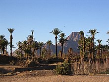
At its northern limit, the Sahara reaches to the Mediterranean Sea in Egypt and part of Libya. In Cyrenaica and the Maghreb, the Sahara borders the Mediterranean forest and scrub ecoregions of North Africa, which have a Mediterranean climate characterized by a rainy winter season. According to the botanical criteria of Frank White,10 as well as the geographer Robert Capot-Rey,1112 the northern limit of the Sahara corresponds to the northern limit of date palm cultivation and the southern limit of esparto grass, a Typical herb of the Mediterranean climate zone of the Maghreb and the Iberian Peninsula. The northern limit also corresponds to the 100 mm precipitation isoline.13
To the south, the Sahara is bounded by the Sahel, a belt of dry tropical savannah with a rainy summer season that stretches across the African continent from east to west. The southern limit of the Sahara is botanically indicated by the southern limit of Cornulaca monacantha (a drought-tolerant species of the Chenopodiaceae), or by the northern limit of Cenchrus biflorus, a typical Sahelian grass.1112 According to the climatic criteria, the southern limit of the Sahara corresponds to an isoline of 150 mm of annual precipitation (annual average, since rainfall varies annually).13 Over large areas of several countries, including Algeria, Chad, Egypt, Libya, Mali, Mauritania, Morocco, Niger, Western Sahara, Sudan and Tunisia. It is one of the three distinctive provinces that form the massive physiographic divisions of Africa.
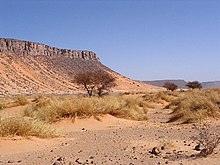
The landforms of the Sahara have been progressively sculpted by both wind and occasional rainfall. This effect of time and climate has shaped sand dunes and dune fields or seas of land (erg), rock valleys (hamada), gravel flats (reg), dry valleys, and salt flats (shatt or chott). There are also unusual landforms such as Richat structures of Mauritania.
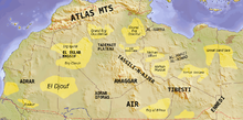
The Sahara contains a multitude of deeply dissected mountains, as well as mountain ranges, some of which are volcanic. These mountain formations include the Air Mountains, the Ahaggar Mountains, the Saharan Atlas, the Tibesti Mountains, the Adrar of the Iforas, and the Red Sea Hills. The highest point in the Sahara is Emi Koussi, a shield volcano in the Tibesti massif located in northern Chad.
Most of the rivers and streams in the Sahara are seasonal or intermittent, the one major exception being the Nile River, which crosses the desert from its source in central Africa to empty into the Mediterranean. Underground aquifers can sometimes reach the surface, forming oases, such as those at Bahariya, Gardaya, Timimoun, Kufra and Siwa.
The central part of the Sahara is hyper-arid, with sparse vegetation. The northern and southern extremes of the desert, along with its highlands, have areas of grass and xerophytic scrub, with taller trees and shrubs in the wadis where moisture is concentrated. and it is one of the ones that covers almost entire countries due to its great growth throughout history
At its northern limit, the Sahara reaches to the Mediterranean Sea in Egypt and part of Libya. In Cyrenaica and the Maghreb, the Sahara borders the Mediterranean forest and scrub ecoregions of North Africa, which have a Mediterranean climate characterized by a rainy winter season. According to the botanical criteria of Frank White, as well as the geographer Robert Capot-Rey, the northern limit of the Sahara corresponds to the northern limit of date palm cultivation and the southern limit of esparto grass, a typical grass of the Mediterranean climate zone of the Maghreb and the Iberian Peninsula. The northern limit also corresponds to the 100 mm precipitation isoline.
To the south, the Sahara is bounded by the Sahel, a belt of dry tropical savannah with a rainy summer season that stretches across the African continent from east to west. The southern limit of the Sahara is botanically indicated by the southern limit of Cornulaca monacantha (a drought-tolerant species of the Chenopodiaceae), or by the northern limit of Cenchrus biflorus, a typical grass of the Sahel. According to the climatic criteria, the southern limit of the Sahara corresponds to an isoline of 150 mm of annual precipitation (annual average, since rainfall varies annually).
Climate
The climate of the Sahara has undergone enormous variations over time, swinging from wet to dry over the past hundreds of thousands of years. This variability is due to a 41,000-year cycle in which the Earth's axis changes between 22° and 24.5°.
Currently (2000), we are in a dry spell, but the Sahara is expected to green again in 15,000 years. When the North African monsoon is at its strongest, annual precipitation and subsequent vegetation in the Sahara region increase, resulting in conditions commonly known as the " Green Sahara". For a relatively weak North African monsoon, the opposite is true, with decreased annual precipitation and less vegetation resulting in a phase of the Saharan climate cycle known as the 'Sahara desert'.
During the last ice age, the Sahara was even larger than it is today, extending south beyond its present limits. The end of the glacial period brought more rain to the Sahara, beginning in the year 8000 to. C. to 6000 B.C. C., perhaps due to the existence of low pressure areas over the northern polar ice caps.
Once the ice sheets disappeared, the northern Sahara dried up. In the south of it, however, the drier trend was soon offset by the monsoon, which brought rain farther north than it does today. In this period, a monsoon climate still existed in the Sahara. Monsoons are formed by heating the air above the earth's surface during the summer. The warm air rises and pulls in cool, moist ocean air, which causes rain. Thus, although it seems counterintuitive, the Sahara was more humid when it received more insolation in the summer. This was caused by a stronger inclination of the orbital axis than currently exists (24.5 degrees inclination compared to the current 23.4°), the apse taking place in July around 7000 BC. C.
Around 4200 B.C. The monsoon withdrew to the south, in the environment where it is today, leading to a progressive desertification of the Sahara. The Sahara is now as dry as it was about 13,000 years ago. These conditions are responsible for of what has come to be known as the pumping theory of the Sahara.
The Sahara is generally considered to have one of the most severe climates in the world today. The frequent north-east wind often causes dust storms and mini-tornadoes. When this wind reaches the Mediterranean, it is known as the sirocco and often reaches hurricane speeds in North Africa and southern Europe. Half of the Sahara receives less than 20 mm of rain per year, and the rest receives no more than 100 mm annually. Rainfall occurs very infrequently, but when it does occur it is usually torrential, usually after long dry spells. The southern border of the Sahara, as measured by the amount of rainfall, has advanced and then retreated between the 1980s and 1990s. As a result of the drought in the Sahel, the southern border has moved further south, at least 130 km during that period.
The latest signs indicate that the Sahara and surrounding regions are becoming increasingly greener as a result of increased rainfall. Satellite images show that a greening of the Sahel may have taken place between 1982 and 2002, and in both eastern and western Sahara a trend of more than twenty years of increasing grazing areas and flowering has been observed. of trees and bushes. In this sense, the observations of climatologist Stefan Kröpelin stand out.
Ice and Snow
On February 18, 1979, snow fell on numerous places in southern Algeria, including a half-hour snowstorm that halted traffic in Gardaya, and was billed as the "first time since there has been memory". The snow disappeared in a matter of hours. Many Saharan mountain ranges, however, receive snow more regularly. Although relative humidity is low in arid environments, absolute humidity is high enough for moisture to condense in high mountainous latitudes. In winter, temperatures drop enough at the summit of Tahat to cause snowfall every three years on average. The Tibesti Mountains receive snow on their peaks above 2,500m once every seven years on average.
On January 17, 2012, snow fell in many places in western Algeria. Strong winds blew snow across roads and buildings in the province of Béchar.
Ecoregions
The Sahara comprises different distinctive ecoregions, which with their variability in terms of temperature, rainfall, elevation, and soil, are home to distinct plant and animal communities.
The Atlantic coastal desert is a narrow strip along the Atlantic coast, where the fog generated on the coast by the cold current of the Canary Islands provides enough moisture to support a variety of of lichens, succulents and shrubs. It covers 39,900 km² in Western Sahara and Mauritania.
The north-Saharan steppes and forests follow one another in the north of the desert, close to the Mediterranean forest regions of the north of the Maghreb and Cyrenaica. Winter rains maintain scrub and dry forests that form a transitional landscape between the Mediterranean climate and the authentic hyper-arid climate of the Sahara to the south. It covers 1,675,300 km² of Algeria, Egypt, Libya, Mauritania, Morocco, Tunisia and Western Sahara.
The Sahara desert ecoregion covers the hyper-arid portion of the Sahara where rainfall is minimal and sporadic. Vegetation is rare, and this ecoregion consists mainly of sand dunes (erg, chech, raoui), stony valleys (hamadas), gravel plains ( reg), dry valleys (wadis) and salt flats. It covers 4,639,900 km² of Algeria, Chad, Egypt, Libya, Mali, Mauritania, Niger and Sudan.
The Southern Saharan steppe and bushveld is an ecoregion that spans a narrow east-west band between the hyper-arid Sahara and the savannahs of the Sahel to the south. The movements of the equatorial Intertropical Convergence Zone (ITCZ) bring summer rainfall during the months of July and August that average between 100 and 200 mm but vary widely from year to year. These rains maintain grassy pastures in summer, with dry forests and scrubland following seasonal streams. This region spans 1,101,700 km² of Algeria, Chad, Mali, Mauritania, and Sudan.
In the xeric forest of western Sahara, several volcanic highlands provide a cooler and wetter environment, which allows the existence of Saharan-Mediterranean forests and scrublands. The region covers 258,100 km², mostly in the Tassili n'Ajjer of Algeria, with small enclaves in the Aïr of Niger, the Adrar Plateau of Mauritania, and the Adrar of the Iforas of Mali and Algeria.
The Tibesti Massif Xeric Forest and Mount Uweinat is an ecoregion consisting of the Tibesti Highlands and Mount Uweinat. High and more regular rainfall as well as milder temperatures allow the existence of forests of date palms, acacias, myrtus, oleanders, tamarisks, and many rare and endemic plants. This region covers 82,200 km² in the Tibesti of Chad and Libya, and Jebel Uweinat on the border of Egypt, Libya and Sudan.
The halophyte Sahara is an area of seasonally inundated saline depressions that is home to halophyte salt-adapted plant communities. Saharan halophytes cover 54,000 km², encompassing the Qattara and Siwa depressions in northern Egypt, the Tunisian salt lakes in central Tunisia, Algeria's Chott Melghir, and small areas of Algeria, Mauritania, and Western Sahara.
The Tanezrouft is one of the harshest regions on planet Earth and one of the driest in the Sahara, with no vegetation and very little life. It lies along the borders of Algeria, Niger, and Mali, west of the Ahaggar Mountains.
Flora and fauna
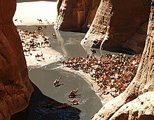
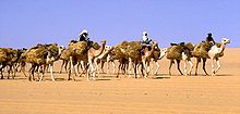
Dromedaries and goats are the most frequently found domestic animals in the Sahara. Given its qualities, especially its resistance and speed, the dromedary is the favorite animal of nomadic populations.
The yellow scorpion can be 10 cm long. Its venom contains a significant amount of toxins such as agitoxin and scyllatoxin and is very dangerous. However, a sting from this scorpion can rarely kill a full-grown male.
Several species of fox live in the Sahara, including the fennec, pale fox, and Rüppell's fox. The addax, a large white antelope, can spend about a year in the desert without drinking water. The dorcas gazelle is a North African gazelle that can also go long periods of time without hydration. Other notable gazelles include the white gazelle and the lady gazelle.
The Sahara cheetah lives in Algeria, Togo, Niger, Mali, Benin and Burkina Faso. There are less than 250 mature specimens left that are very cautious, fleeing from any human presence. The cheetah avoids the sun from April to October, seeking the shelter of bushes and acacias. They are extraordinarily pale.
Other animals in this area include monitor lizards, hyracoids, sand vipers, as well as small populations of African wild dog, present in perhaps as few as fourteen countries, and occasionally ostriches. There are other animals in the Sahara, in particular birds like the African silver-billed songbirds, among others. Small desert crocodiles also exist in Mauritania and on the Ennedi Plateau of Chad.
It is estimated that the central Sahara has five hundred species of plants, an extremely low number considering its immense extent. Plants such as acacias, palms, succulents, thorny scrub, and different grasses have adapted to the arid conditions, growing less to avoid water loss from strong winds, storing water in their thick stems for use in dry periods, having long roots that travel horizontally to reach the largest area of water as well as through the arrangement of small and thick leaves or needles that prevent water loss by evapotranspiration. The leaves can become completely dry and recover later.
Human activity often affects habitat in areas where there is permanent water (oasis) or where water appears near the surface. In these places, the pressure on natural resources can become intense. Mammal populations have suffered from this human presence, their numbers having been reduced as a result of hunting and other human activities.
History
Nubians
During the Neolithic, before desertification got underway, around 9500 B.C. C. the area of central Sudan had been a rich environment that supported important populations that inhabited areas currently occupied by the desert, such as the Wadi el-Qa'ab. Around the 5th millennium B.C. C., the peoples who inhabited what is now known as Nubia, fully participated in the so-called "agricultural revolution", leading a sedentary lifestyle and domesticating plants and animals. Rock art preserved on rocks from the Sahara indicates the presence of a cattle cult similar to that found in Sudan and other present-day African pastoralist societies. Megaliths have been found at Nabta Playa, remains of what are likely the the earliest examples of human archaeoastronomy instruments and predated Stonehenge by nearly 2,000 years. This complexity, as observed at Nabta Playa, and as deduced from the different levels of authority within the societies of At the time, they likely formed the basis of the structure of both the Neolithic society of Nabta and the Old Empire of Egypt.
Egyptians
Circa 6000 B.C. C., the predynastic Egyptians who inhabited southwestern Egypt already herded cattle and dedicated themselves to the construction of important buildings. The subsistence of the organized and permanent settlements of Predynastic Egypt from the middle of the sixth millennium B.C. C. focused predominantly on cereal and animal agriculture: cattle, goats, pigs and sheep. Metallic objects replaced the previous stone ones. The working and dyeing of animal skins, pottery, and weaving were common in this era. There are indications of a temporary or seasonal occupation of the city of Fayun in the 6th millennium BCE. C, focusing food activities on fishing, hunting and food gathering. Some arrowheads, knives, and spatulas from this era are readily found here. Objects found in burials include pottery, jewelry, farming and hunting utensils, as well as prepared foods including dried meat and fruit. Burial in desert settings seems to precede and promote Egyptian preservation rites, with the dead also being buried facing west.
Around 3400 B.C. C, the Sahara was as dry as it is today, as a consequence of a reduction in precipitation and an increase in temperatures as a consequence of the change in Earth's orbit, becoming a practically impenetrable barrier for humans. Only scattered settlements, usually centered around oases, can be found thereafter. However, little trade passed through the desert. The one major exception was the Nile Valley. The Nile, however, was impossible to cross at different cataracts, making trade and contact by ship difficult.
Phoenicians
The people of Phoenicia, which flourished around 1200 B.C. C. - 800 B.C. C., created a confederation of kingdoms across the entire Sahara to Egypt. They generally settled along the Mediterranean coast, as well as in the Sahara, among the peoples of Ancient Libya, who are the ancestors of the Berber-speaking peoples of North Africa and present-day Sahara, including the Tuareg. from the central Sahara.
The Phoenician alphabet seems to have been adopted by the ancient Libyans of North Africa, this Tifinagh being still used by Berber-speaking camel herders in present-day central Sahara.
Sometime between 633 and 530 B.C. C, Hanno the Navigator established or reinforced the Phoenician colonies of Western Sahara, but any possible ancient remains have disappeared leaving virtually no trace.
Greeks
Around 500 B.C. C, the Greeks came to the desert. Greek traders spread along the east coast of the Sahara, establishing trading colonies in the Red Sea area. The Carthaginians explored the Atlantic desert coast, but rough waters and a lack of markets explain their sparse presence further south in modern Morocco. The centralized states therefore surrounded the wasteland to both the north and east, although the desert itself remained outside of their control. Attacks by the nomadic Berber peoples of the desert were a constant cause of concern for those who lived on the fringes of the desert.
Urban civilization
An urban civilization, the Garamantes, rose around 500 B.C. in the heart of the Sahara, in a valley known today as Wadi al-Ajal in Fezan, Libya. The Garamantes achieved this development by tunneling deep into the mountains flanking the valley to obtain fossil water and lead her to their fields. The Garamantes grew in number and strength, conquering their neighbors and capturing scores of slaves (who were used in the work of digging new tunnels). The ancient Greeks and Romans knew of the Garamantes, viewing them as uncivilized nomads. However, they traded with them, having found some Roman baths in the capital of the Garamantes, Garama. Archaeologists have found eight major cities and a host of other important settlements in the territory of the Garamantes. When all available water in the aquifers was depleted, the Garamantes civilization collapsed, unable to afford to continue tunneling into the mountains.
Berbers
The Berbers occupied (and still do) a good part of the Sahara. The Garamante Berbers built a prosperous empire in the heart of the desert. Tuareg nomads have continued, up to the present, to inhabit and move across vast areas of the Sahara.
Arab Islamic expansion
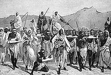
The Byzantine Empire controlled the northern shores of the Sahara from the 5th century to the VII. When the Muslim conquest of the Maghreb began between the mid-VII century and the beginning of the VIII, Arab and Islamic influence spread rapidly throughout the Sahara. By the end of the year 641 all of Egypt was in Arab hands. Trade across the desert intensified. The kingdoms of the Sahel, especially the Ghana Empire and the Mali Empire, increased their wealth and strength thanks to the export of gold and salt to North Africa. The emirates that followed one another along the coast of the Mediterranean Sea sent manufactured goods and horses to the south. Salt was exported from the Sahara itself. This process turned the scattered oasis communities into trading centers and brought them under the control of the empires that sat on the fringes of the desert. An important slave trade took place across the wasteland. It is estimated that from the X century and up to the XIX, between 6,000 and 7,000 were transported north each year.
Trade across the Sahara persisted for many centuries until Europe's development of the caravel allowed ships, initially from Portugal and soon from all over Western Europe, to navigate around the desert and grab resources at their source, the Guinea region. The Sahara was soon marginalized.
Ottoman Turkish Era
Since the 16th century, the northern part of the Sahara, including coastal areas of present-day Algeria and Tunisia, as well as parts of present-day Libya, along with the semi-autonomous kingdom of Egypt, were occupied by the Ottoman Empire. Since 1517, Egypt was considered part of the Ottoman Empire, a property that allowed them to control the Nile Valley, the eastern Mediterranean and North Africa. The benefit of these conquests for the Ottomans was considerable, allowing them freedom of movement for their citizens and goods. Trade took advantage of Ottoman land routes to bring spices, gold, and cloth from the East, manufactures from Europe, and slaves and gold from Africa. Arabic continued to be the local language and Islamic culture was strengthened. The Sahel and South Sahara regions were home to numerous independent states as well as nomadic Tuareg clans.
European colonialism
Modern exploration of the Sahara was initiated under the auspices of the Association for promoting the discovery of the interior parts of Africa, founded in 1788 and transformed in 1830 into the Royal Geographical Society. Friedrich Hornemann, the first European to try to cross the Sahara from north to south (1798-1800) died shortly before reaching Niger. Oudney, Denham and Clapperton (1822-182]) made the first voyage. Scientific research began in the 1850s with the works of the great German explorers Heinrich Barth, Gustav Nachtigal, Friedrich Gerhard Rohlfs, and Oskar Lenz. The representatives of France, and among them in the first place Émile Félix Gautier, became the ones who made the greatest contribution to the geographical knowledge of the great desert.
European colonialism in the Sahara began in the 19th century. France conquered the regency of Algiers from the Ottomans in 1830, and French rule expanded south from Algeria and east from Senegal into upper Niger to include present-day Algeria, Chad, Mali, then known as Sudan French and included Timbuktu, Mauritania, Morocco (in 1912), Niger and Tunisia (from 1881). By the start of the 20th century, trans-Saharan trade had declined significantly as goods began to move using more efficient modern methods, like the plane, instead of across the desert in camel caravans.
The French colonial empire was then the dominant force in the Sahara. He established regular air links from Toulouse to Oran and over the Hoggar to Timbuktu as well as west to Bamako and Dakar, as well as trans-Saharan bus services operated by the Compagnie Générale Transsaharienne (founded 1927). A film recorded by the captain of aviation René Wauthier documents the first convoy of trucks that crossed the desert from Algiers to Chad.
Egypt, under Muhammad Ahmad and his successors, conquered Nubia in 1820-22, founding Khartoum in 1823, and subsequently conquering Darfur in 1874. Egypt, including Sudan, became a British protectorate in 1882. Egypt and the United Kingdom they lost control of the Sudan between 1882 and 1898 as a result of the Mahdi War. After its capture by British troops in 1898, the Sudan became an Anglo-Egyptian commonwealth.
Spain captured present-day Western Sahara in 1874, though Río del Oro remained largely under Tuareg influence. In 1912 Italy seized parts of what is now known as Libya from the Ottomans. To promote the Catholic religion in the desert, Pope Pius IX appointed an apostolic delegate of the Sahara and Sudan in 1868. Subsequently, his jurisdiction was reorganized into the Apostolic Vicariate of the Sahara.
Dismemberment of empires and after
Egypt became independent from Great Britain in 1936, although the 1936 Anglo-Egyptian Treaty allowed Britain to maintain troops in Egypt and maintain Anglo-Egyptian commonwealth in the Sudan. British military forces left the country in 1954.
Most of the Saharan states achieved independence after World War II: Libya in 1951, Morocco, Sudan, and Tunisia in 1956, Chad, Mali, Mauritania, and Niger in 1960, and Algeria in 1962. Spain exited the Western Sahara in 1975, and it was divided between Mauritania and Morocco. Mauritania left it in 1979, and Morocco continues to hold onto its territory.
In the post-World War II era, multitudes of mines have been developed to utilize the natural resources of the desert. Among these are important oil and natural gas deposits in Algeria and Libya, and important phosphate deposits in Morocco and Western Sahara.
Several Trans-African Highways have been proposed across the Sahara, including the Cairo-Dakar Highway along the Atlantic coast, the Trans-Saharan Highway from Algiers to the Mediterranean to Kano in Nigeria, the Tripoli-Cape Town Highway from Tripoli in Libya to N'Djamena in Chad, and the Cairo-Cape Town Highway that runs along the Nile. Each of these highways is partially complete, with significant incomplete areas and unpaved sections.
People and languages
Arabic dialects are the most widely spoken languages in the Sahara, from the Atlantic to the Red Sea. Berber peoples are found from western Egypt to Morocco, including Tuareg herdsmen from central Sahara. The Beja peoples live in the Red Sea Hills of southeastern Egypt and eastern Sudan. Arabic, Berber and their variants regrouped under the term Amazig (which includes the aboriginal language spoken by the original Berber inhabitants of the Canary Islands) and the Beja languages are part of the Afroasiatic or Hamito-Semitic language family. [citation required]
Contenido relacionado
Fourteen points
Juan Fernandez Archipelago
Annex: Municipalities of the province of Cuenca
