
Sacramento Colony
Colonia del Sacramento, known locally as Colonia, is the capital of the department of Colonia, in southwestern Uruguay. It is located on the north —left— bank of the Río de la Plata, 177 kilometers from Montevideo and off the coast of Buenos Aires, Argentina, from which it is only about 50 kilometers (in a straight line).
It is located on the cape formed by the tips of San Pedro and Santa Rita. Its old town, the historic quarter that covers 12 hectares on the western edge of the city, was declared a World Heritage Site in 1995, illustrating the successful fusion of Portuguese, Spanish and post-colonial styles. The plan is of Portuguese origin and contrasts with the standard prescribed by the Spanish law on the West Indies. It is characterized by its narrow stone streets, which highlight its military tradition.
Its proximity to the city of Buenos Aires strongly links it to it. There are numerous travelers who arrive and depart for that destination and also the inhabitants of Buenos Aires who have properties in it. There is a project to join both banks through a binational bridge. The distance between both cities crossing the Libertador General San Martín Bridge is about 500 kilometers.
History
Background


The Treaty of Tordesillas, which divided the lands of the Kingdom of Spain and the Kingdom of Portugal in South America, virtually ceased to exist when the Spanish branch of the Habsburgs ascended the Portuguese throne in the Portuguese succession crisis of 1580. Philip II of Spain ended up being recognized as King of Portugal in the Cortes de Tomar in 1581. With the ascension of the King of Spain to the throne of Portugal, the union of ancient Spain was completed. Which means that there was no longer a legal border between the Castilian colonies and the Portuguese colonies. Portugal remained within the Spanish crown for almost 60 years (1580-1640). During this time Portugal had the opportunity to claim land from the monarchy.
The governorate of Río de la Plata, which belonged to the immense Viceroyalty of Peru and was located to the west of the meridian established by the Treaty of Tordesillas, constituted the Spanish southern limit with Portuguese Brazil.
Given the inaccuracies of the treaty and the measurement methods of the time, the Portuguese considered that the line should extend to the west of the meridian set by the Spanish and in this sense they used to include the entire Banda Oriental within their claim. There were important differences between the two crowns regarding the line of the Treaty of Tordesillas since Spain maintained that the 370 leagues should be measured from the Island of São Nicolau or San Nicolás de Cabo Verde while Portugal claimed that the measurement be made from the Island of Santo Antão or San Antonio Island.
This was the main reason for the Portuguese to constantly advance towards the South American west on the Spanish border.
Portuguese Foundation of Colônia do Sacramento
On October 9, 1678, Field Master Manuel Lobo assumed the command of Governor of the Captaincy of Rio de Janeiro in Brazil.
At the end of 1679 Lobo, with the support of Rio de Janeiro merchants eager to consolidate their business in South America, began preparing an expedition to the Río de la Plata.
He headed for Santos on October 30 of that year, where he finished the expeditionary preparations and left at the beginning of December of that year.
The fleet was made up of two ships, two brigantines and other smaller ships that transported four companies with 400 soldiers and artillery with which they planned to defend themselves in case they were attacked by the natives. The expedition transported construction and farm elements and 18 cannons for the plaza.
On January 1, 1680, the Portuguese arrived at the mouth of the Río de la Plata and on the 20th they occupied San Gabriel Island.
Between the 20th and 28th of that same month, Manuel Lobo founded the Nova Colônia do Santíssimo Sacramento, which was the first European settlement and the first and oldest city in what is now Uruguay.
On February 25, Lobo wrote to the Chamber (Cabildo) of São Paulo, asking for help and food to maintain the new colony.
The Portuguese settlement was located in front of Buenos Aires, in the eastern territory of the Uruguay River of the Spanish Governorate of the Río de la Plata, which at that time was governed by José de Garro.
In addition to the military purpose, the establishment in Colonia served the interests of the commercial sector of the Portuguese bourgeoisie interested in recovering access to the exchange with Buenos Aires, legally protected by the “asiento” privilege. The suppression of the Portuguese monopoly on the supply of African slaves in 1640 cut off the possibility of sending Brazilian products such as sugar, tobacco and cotton and European manufactures to Spanish America in exchange for silver from Upper Peru. In addition, there was a lot of interest from the Portuguese in establishing a border framework, which would serve as a goal to reach the Río de la Plata by land. Cologne became a dynamic center for smuggling from Portugal and England.
Spanish occupation

Aware of the Portuguese presence in Colonia, the Spanish governor and captain general of the Río de la Plata, José de Garro, sent from Buenos Aires on February 7, 1680, the sumaca San José to the Island of San Gabriel, where he made contact with the Portuguese and upon his return reported that they had established an establishment, although without being able to specify the place.
Garro began the mobilization of troops to dislodge the Portuguese. He asked the viceroy of Peru for support, summoned the local militias that were joined by the governorate of Paraguay and the governorate of Tucumán, and after several months of preparation he assembled an army of 480 Spanish soldiers, commanded by the master of field Antonio de Vera and Mujica. The cities of Corrientes and Santa Fe sent one company each, and Tucumán sent four. The superior of the Jesuit missions on the Uruguay River gathered 3,000 Indians in the reduction of Yapeyú, of which 1,500 were on horseback, and dispatched them to Colonia del Sacramento.
Lobo asked for reinforcement troops for Colonia, but the sumaca and the boat that transported them were shipwrecked at the mouth of the Río de la Plata.
On August 7, 1680, Spanish forces stormed and took Colonia, defeating the Portuguese. The square was renamed by the Spanish, calling it "Fort del Rosario". Lobo, taken prisoner, was transferred to Buenos Aires, where he died on January 7, 1683.
First return to Portugal
Portuguese protests resulted in the signing of the Provisional Treaty of Lisbon on May 7, 1681, which provided for the return of Colonia to Portugal, along with artillery, weapons and supplies, and the Spanish crown's disapproval of the action carried out by Garro, who was sanctioned.
Trade from the plaza with the surrounding Spanish territories was prohibited and repairs to the walls could only be carried out on land. The final decision on sovereignty in the area would be made by a mixed commission, which was to meet at the end of two months and if no agreement was reached, Pope Innocent XI would be asked to resolve it. The treaty was ratified by Spain on May 25, 1681 and by Portugal on June 13 of the same year. When no agreement was reached, the Spanish crown sent a commissioner to Rome, but the Portuguese did not and the pope let the stipulated period of one year pass.
On February 12, 1683, the governor of the River Plate, José de Herrera y Sotomayor, handed over the colony to the governor of Rio de Janeiro, the field master Francisco Naper. The colony was refounded by the Portuguese in February 1683, renaming it Nova Colônia do Santísimo Sacramento, giving it more extension and solidity.
On June 18, 1701, the Treaty of Lisbon was signed, stipulating that Spain would definitively cede Colonia del Sacramento to Portugal, revoking the Spanish-Portuguese agreement of 1681.
Spanish reconquest and second return to Portugal
In November 1704, within the framework of the War of the Spanish Succession, the Spanish captain Juan de Lacoizqueta commanded the third of Santa Fe, paying the expenses of the expedition from his own wealth and, after a siege of five months, he managed to take Cologne in March 1705, which earned him promotion to field master.
Under the command of the Governor of the River Plate, Alonso de Valdés e Inclán, who had proceeded to demolish the defenses, the occupation at the hands of the Spanish lasted until 1715, the date on which it had to be returned to the Portuguese Crown, since according to the Treaty of Utrecht—which had begun in 1713—would pass to that nation. Under Portuguese sovereignty, the colony became a focus for Portuguese and British smuggling into Spanish possessions.
Portuguese Foundation of Montevidéu and its Hispanic occupation
On November 22, 1723, the Portuguese field master Don Manuel de Freitas da Fonseca founded the Forte de Montevidéu. Quickly, on January 22, 1724, the Spanish in Buenos Aires displaced the Portuguese, so that in 1726 Felipe V of Spain commissioned the governor of Buenos Aires, Bruno Mauricio de Zabala, to build and fortify Montevideo in order to control the contraband.
New Spanish reconquest and third return to Portugal
The Treaty of Madrid of 1750, stipulated that Spain would keep the Colonia del Sacramento, ceding in exchange to Portugal the Jesuit reductions called the Eastern Missions or The Seven Mission Towns, located in present-day Rio Grande do Sul, Brazil. The entry of Spain into the Seven Years' War in 1762 interrupted the talks, but Pedro de Cevallos reoccupied Colonia. However, the war ended with the signing of the Treaty of Paris in 1763, which established the return of the disputed Colony to Portugal.
Definitive occupation of Colonia de Sacramento by Spain
In 1777, Carlos III of Spain sent a second expedition to Río Grande —already with Cevallos in his capacity as viceroy of the recently created Viceroyalty of Río de la Plata— which was made up of more than 80 ships and 9,000 men, among them the Saboya Regiment under the command of Lieutenant Colonel Antonio Olaguer Feliú, and which definitively occupied Colonia, a conquest that was endorsed by the Treaty of San Ildefonso, signed that same year, by which the Spanish-Portuguese border was set at the Río Negro, leaving Spain in power of the southern half of current Uruguay. Cevallos founded with Portuguese from the Azores Islands the city of San Carlos in Maldonado.
Later events
During the second of the English invasions of the Río de la Plata, on March 5, 1807, the British seized Colonia from Spanish rule, promoting independence ideas (Francisco Miranda - Pophan pact). From September 1807 José Gervasio Artigas internally exercised command of the city on behalf of Spain.
After the May Revolution occurred in 1810, Colonia, after receiving the support of the forces of Eustoquio Díaz Vélez, joined the insurrectionary movement against the Spanish viceroyalty authorities.
In 1813, Colonia was part of the Eastern Province.
In 1818, 40 years later, it was reoccupied by Portugal during the Luso-Brazilian invasion of 1816.
On December 2, 1828, it was definitively placed under the sovereignty of the Eastern State of Uruguay.
The railroad reached the city on April 1, 1901.
Monuments and places of interest
Historic Old Town

The historic center of Cologne was declared a World Heritage Site by UNESCO in 1995. Its architecture is a fusion of Spanish, Portuguese and post-colonial architectural styles. The singular preservation of the environment has allowed the use of its streets as exteriors for several period films, such as That is not spoken about (1993) by María Luisa Bemberg, with Marcello Mastroianni as the protagonist. The Street of Sighs is one of the most typical and well-known.
In Punta de San Pedro is the lighthouse that was built in 1857 and is made up of a white-painted masonry tower with ruins of an old building at the foot. It has a dome with red and white radial stripes. Its focal height is 34 meters above sea level and its characteristic is a flash of white light every 9 seconds, being visible at 6.4 miles in clear weather.
Halfway between the wall, also called "Puerta de Campo", Gate of the Citadel of the historic center and the port, is the old railway station of Colonia.
Recovery of the old town
After almost 200 years, what is now called the Historic District of Colonia del Sacramento was "ruin, destruction and abandonment," as mentioned in the research paper "De prostituta a señora. The recent history of Colonia del Sacramento". It was "a forgotten place and the last place anyone would choose to live." At night, "the owners of its streets (...) were the prostitutes and their clients". During the day, those who survived among its ruins were allowed to be seen.
In 1968, Federico García Capurro and Jorge Otero Mendoza convinced President Jorge Pacheco Areco of the importance of recovering the historic neighborhood. Until that year, different initiatives had taken place, but none had prospered and had been limited to specific interventions, such as the one that took place in the Cathedral in the 1950s, motivated by water leaks.
On October 10, 1968, Pacheco signed the decree by which the Honorary Executive Council for the Preservation and Reconstruction of the Antigua Colonia del Sacramento (CEH) was created and assigned the corresponding resources to start the works.
The works included the reconstruction of the entire wall visible today (in 1968 it was not there), the Puerta de Campo (it was rebuilt with some original and new stones), the Spanish Museum, the Portuguese Museum, the Casa de Nacarello, the Museo del Indio and the Casa del Virrey, in the ruins of the Convent, among other interventions that recovered the historic neighborhood.
The members of the CEH and those responsible for carrying out the restoration work were: Fernando O. Assunção (as President and replacing Pardo Santayana originally appointed), Rogelio Fusco Vila, Artigas Miranda Dutra, Pedro Costa, Leandro de Esteban Gómez and Miguel Angel Odriozola. The latter, born in Cologne, was responsible for directing the works. As an honorary member of the CEH, and in recognition of the initiative of the project, Jorge Otero Mendoza was named.
The works were ready to be inaugurated in 1972.
Real de San Carlos

The Real de San Carlos is the area on the outskirts of Colonia from where Spanish troops laid siege to the Portuguese stronghold in 1761. Its name is a tribute to King Carlos III of Spain. It has a small chapel dedicated to Saint Benedict of Palermo, the first black saint of the Catholic Church. Today it is a residential area, with many weekend houses, where you can enjoy quiet beaches on the Río de la Plata with fine sand.
In the Real de San Carlos it was developed at the beginning of the XX century, at the initiative of the Argentine businessman Nicolás Mihanovich, a tourist complex, now abandoned, which had a hotel-casino (of which only one "Annex" was built), a bullring, unique in the Río de la Plata (since the one in Buenos Aires in the current Plaza San Martín no longer existed), a Basque pelota fronton (the largest in South America) and its own power station. In order to build this complex, Mihanovich was associated in Europe with the engineer Eiffel, who recommended for the job a group of Italians who at that time were assembling the monumental Cairo Train Station, headed by Capo Mastro Giuseppe Formica Selvagi. This is how in 1903 the aforementioned professional born in Vizzini, Sicily, arrived in the Río de la Plata, together with his brother Víctor and specialized personnel. The first thing that was faced was the construction of a brick factory to supply their local needs, using sand and land from the beaches of El Real, with which precarious houses were built for the workers. The bullring was then built with the metal parts from France and all the rest of the walls, stairs and gates, among other elements. Formica also built the library, shaped the Hippodrome, and raised the magnificent ball pediment.
The Italians married young Uruguayans and settled in Colonia.
The apartment building on Corrientes and Pueyrredón, immortalized in the famous poem "Seventy balconies and no flowers" by Baldomero Fernández Moreno, plus other minor works in the Palermo neighborhood, such as the one in Cabrera 5722, which he built for his own family.
Free Zone
On the Río de la Plata and 600 m from the Port of Colonia, the Colonia Free Trade Zone is located on a 22 ha property. It was created in 1923 by the Uruguayan State. In 1994 its farm was privatized.
Photo Gallery

Cartel signaling Sigh Street.
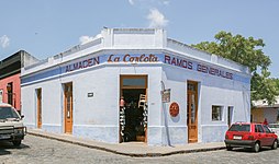
Trade.
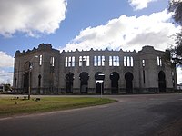
Old Bullring.

Colonia del Sacramento yacht port.

Classic car parked on the Royal Street, inside the historic center

Street "Misiones de los Tapes" at night, in the historic center

Cologne and its landscape. A sunset in an inn

Mechanized Infantry Battalion No. 4
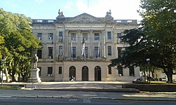
Municipal Palace of Cologne

Overview of the city

Beautiful evening with the sign in Colonia de Sacramento


On the premises of the old Sudamtex textile company, a few meters from the port, is Colonia Shopping. Inaugurated in December 2006, it has an area of more than 5,000 m² built and more than 5,800 m² exterior. The complex has a parking lot for 120 places.
Yacht harbor
At Punta Santa Rita, on the north side of the cape, there is a small port for sports and pleasure boats called "Puerto Viejo". The depths are 2.00 and 2.50 meters referred to the local hill. The mooring capacity is more than 160 boats. In the summer season its facilities are filled with units of the Argentine flag. It is the place of arrival of regattas of the Río de la Plata.
Neighborhoods
Old City (or historic neighborhood), Downtown, New Town, Otto Wulff, Treinta y Tres, San Benito, Real de San Carlos, Real de Vera (El Caño), Cemetery, Los Nogales, Ferrando, El General.[citation required]

.jpg)
.jpg)

San Gabriel and Farallon Islands
About 3 km from Punta San Pedro is San Gabriel Island. It is 24 hectares and is a low island covered with trees. On its north side there is a small cement pier that allows boats with a draft of up to 1.5 m to anchor in its vicinity. On December 28, 1995, it was declared a national park.
In the immediate vicinity is Farallon Island, a small rocky island. On this island there is a lighthouse dating from 1875 and since 1928 it has had machinery that allows it to work automatically at sunset, ceasing to work at sunrise, said lighthouse was declared a national historic monument.
In January 2006 both islands were declared a Historic Monument.
Dr. Alberto Boerger's House
A Uruguayan national historical monument, it is located in the center of La Estanzuela, located at km 11 of Route 50. Place where there is a small museum on agricultural research, as a way of remembering the great contributions made by Dr. Alberto Boerger. His scientific advances, since his establishment in 1914 at La Estanzuela, greatly contributed to agricultural development in the Río de la Plata region, a situation confirmed by the yields of wheat generated in La Estanzuela in this period. This development was of relevance, both for Uruguay and Argentina, since in the period 1920-1924 it meant that a fifth of the wheat surface of Argentina was based on seeds selected by the works of Dr. Alberto Boerger and Dr. Enrique Klein in The Estanzuela. Currently, in this almost hundred-year-old agricultural research station, there is one of the main research centers of the National Institute for Agricultural Research (INIA); called the Dr. Alberto Boerger INIA-La Estanzuela Experimental Station.
East Wing Colony
In 2022, it was confirmed that Colonia was going to do a Silicon Valley in Colonia called 'Colonia Ala Este' to bring more Argentine immigrants due to the bad economy in Argentina doubling its population making its goal to reach about 60,000 people in total in Colonia. With an initial investment of more than US$100 million, it was planned to build a sustainable city open to the community to generate a hub for the knowledge economy industry on a 500-hectare site, including forests and seven kilometers of coastline. with beaches like Calabrés and Fernando.
Getting around in Colonia del Sacramento
Bike Rental
In the city of Colonia del Sacramento there is the possibility of renting bicycles as a means of transport, bicycles are widely used by tourists who come to visit this city and it is a very easy and effective means
Car Rental
Another means of transportation that you can use in this city are the Golf Carts, this service that Colonia offers is also easy, effective and also fast. In the golf carts you can transport yourself around the city in a few minutes
Urban Transport
The companies Sol Antigua and ABC Coop are in charge of urban transportation in the city of Colonia del Sacramento. It has 3 lines of Urban Buses every day.
- Linea A: Real de San Carlos-Centro (ABC Coop)
- Line C: "Urbano" Real de San Carlos-Centro (Old Sun)
- Line D: The General-Center for Nogales, Ferrando and Hospital (Sol Antigua)
The schedules of the urban buses can be found on the page of the Municipality of Colonia: Urban Transport Schedules
Geography
Seismicity
The region responds to the «Punta del Este fault», and to the «Río de la Plata sub-fault»; with low seismicity; and its last expression occurred on June 5, 1888 (134 years) of seismic silence), at 3:20 UTC-3, with a magnitude of 5.5 on the Richter scale. (Río de la Plata earthquake of 1888).
Climate
The climate of Colonia del Sacramento is humid subtropical, with pleasant temperatures and rainfall regularly distributed throughout the year. The average annual temperature is around 17 °C.
| Climogram of Colonia del Sacramento | |||||||||||||||||||||||||||||||||||||||||||||||
|---|---|---|---|---|---|---|---|---|---|---|---|---|---|---|---|---|---|---|---|---|---|---|---|---|---|---|---|---|---|---|---|---|---|---|---|---|---|---|---|---|---|---|---|---|---|---|---|
| E | F | M | A | M | J | J | A | S | O | N | D | ||||||||||||||||||||||||||||||||||||
92
27 20 | 97
26 20 | 116
24 17 | 95
21 15 | 83
17 12 | 61
14 8 | 64
13 8 | 76
15 9 | 69
17 11 | 106
20 13 | 109
22 16 | 71
25 18 | ||||||||||||||||||||||||||||||||||||
| temperatures in °C • total precipitation in mm | |||||||||||||||||||||||||||||||||||||||||||||||
Conversion Imperial System
| |||||||||||||||||||||||||||||||||||||||||||||||
Twinned cities
 Cartagena de Indias, Colombia (2010)
 Guimarães, Braga District, Portugal
 Olinda, Pernambuco, Brazil (2014)
- Ballots, Rio Grande del Sur, Brazil (2005)
 Quilmes, Province of Buenos Aires, Argentina (2014)
 Valparaiso, Chile (2012)
Contenido relacionado
Annex: Municipalities of the province of Granada
Duke of Mantua
Marshall Islands