
Rural environment


_-_vignoble.JPG)


.jpg)
The terms rural environment, rural landscape, rural area and others allude to concepts that identify the geographical space of the countryside, seen or qualified as opposed to the urban (relative to the town as opposed to the city). It is studied by rural geography.
A community is rural when, due to its offer of natural resources, its inhabitants manage to develop a sense of belonging to the territory such that they are willing to build a society based on said resources.
This is equivalent to the common uses of the terms "field" and "agro". The agrarian should not be confused with the agricultural, since while the former includes all of the rural, the latter is limited to agriculture (without including livestock or other rural activities). Sometimes the term "agropecuario" is used.
The concept of the rural is applied, at different scales, to the territory of a region or a locality whose economic uses are agricultural, agro-industrial, extractive, forestry and environmental conservation activities. Depending on each legislation, there are legal figures that protect or delimit it (as an undeveloped or undeveloped area, differentiated from urban areas or urban expansion), especially for the limitation of urban growth.
The rural landscape also includes areas dedicated to other uses (residential, industrial, transport or services) in municipalities previously classified as rural (according to numerical criteria of population -in Spain nuclei with fewer than 10,000 inhabitants[citation required], in other countries more or less— or functional —that the predominant economic sector is primary—). Therefore, a distinction is usually made between rural landscape (more inclusive) and the concept of agrarian landscape (limited to uses that are strictly agricultural, agro-industrial, extractive, forestry and environmental conservation), although the traditional rural habitat is also usually included as an element of the agricultural landscape, especially when it is dispersed. The rural landscape presents a great diversity, which starts from its very different physical aspects (geomorphology, climate) and its human occupation (historical, legal, economic factors, etc.). Characteristic elements of the rural landscape are livestock and crops, as well as such as the different facilities and equipment used in each form of cultivation (rainfed or irrigated, livestock and intensive or extensive agriculture, subsistence or market, monoculture or polyculture); and especially the plots, which are classified by their size (not necessarily coinciding with the terms latifundio and minifundio, indicators of the concentration of ownership), shape and characteristics (open fields -openfield, rang, township- and enclosed fields -bocage-, etc.)

Satellite image of a large area of rectangular plots dedicated to cotton cultivation, between the White Nile and the Blue Nile, in Sudan.
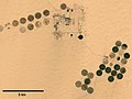
Satellite image of large circular plots irrigated with mobile spray irrigation devices, in Egyptian Sahara.

Aerial photo of an area of small plots of irregular forms delimited with hedges, in the Nudo de los Pastos colombiano.


The definition of "space" or "rural environment" is necessarily as ambiguous as that of urban space, given that the criteria for determining what is a rural population center versus an urban one are not uniform: the quantitative criteria (number of inhabitants) are different in each country or region, while the qualitative criteria (functions or socioeconomic indicators) are affected by different distortions, especially those produced by globalization, which has homogenized and tertiarized lifestyles throughout the world, also affecting rural areas; on whose own activities many of the scientific, genetic and technical advances carried out since the mid-twentieth century in the so-called green revolution have been especially focused. In addition, in the face of the traditional rural exodus (migration from the countryside to the city), in recent decades the so-called "urban exodus" or "neo-ruralization" typical of post-industrial societies that have taken a significant number of people from the city to the countryside, either temporarily or permanently, for different reasons: leisure and rest, rural repopulation initiatives, teleworking, rural tourism, etc...

World distribution of agrarian landscapes proposed by Derwent Stainthorpe Whittlesey:
■ Yellow: nomadic livestock -Sahara, Gobi, arctic areas-
■ Light pink and light brown: extensive market cattle and stabled ranches - low rainfall areas of western North America, South America (Venezuela, Argentina, Greater part of Brazil), southern Africa, Central Asia or Australia-
■ Intense brown: slash-and-burn agriculture -in tropical areas such as Amazonia, Central Africa, Indonesia-
■ Purple: traditional sedentary agriculture in tropical areas - Ethiopia, African Great Lakes, Senegal, parts of the Andes and Mesoamerica, parts of Burma, the Philippines, interior New Guinea-
■ Intense green: intensive subsistence agriculture with rice-dominant farming -in Southeast Asia-
■ Light green: intensive subsistence agriculture without dominant rice farming -in less rainy parts of Asia (northern China, western India, Mesopotamia), Nile Valley and parts of Southern Africa-
■ Red: plantation agriculture -tropical commercial monocultures such as coffee, sugar cane, cocoa, rubber-
■ Orange: Mediterranean agriculture -southern Europe, Maghreb, Mediterranean Levant, areas of California, Chile and South Africa-
■ Intermediate Green 1: Extensive market cereal agriculture -in the grain belt and corn belt of the United States, the extensive or intensive condition of the exploitation is very variable, but in any case they are oriented to the market; the regional division of belts or "belts" is a disputed concept-
■ Intermediate green 2: intensive market livestock and cereal agriculture -great European plain-
■ Intermediate green 3: livestock and subsistence agriculture in mid-latitudes, subjected to strong recent transformations that orient them to produce for the internal market in Turkey and other areas of the Near East, areas of the former Soviet Union, areas of Mexico-
■ Blue: dairy farming -areas of northern Europe, areas between Canada and the United States called dairy belt-
■ Hot Pink: Specialty Horticulture - Southern and Eastern US, called the cotton belt to the south because of cotton dominance -
■ Grey: Badlands
See other simplified and updated versions based on the division: subsistence agriculture (itinerant - intensive - extensive - rice farming) / market agriculture (plantation - Mediterranean - extensive mechanized cereal - polyculture and intensive pastures for food).
Other definitions and characteristics
When talking about the rural landscape, the fact that it is not uniform stands out, traditionally distinguishing in Europe, closed fields and open fields, with intermediate variants, the result of conditioning not only natural but, above all, legal and historical.
Although traditionally these areas have been used primarily for agriculture or livestock, currently large areas may be protected as an environmental conservation area (flora, fauna or other natural resources), indigenous lands, extractivist reserves and have other importance economically, for example, through rural tourism or ecotourism.
Ordinance of the territory in Latin America and the Caribbean.
To delimit the rural area, each country in Latin America and the Caribbean uses particular criteria, such as: (i) number of inhabitants, (ii) size of the population settlement, (iii) availability of basic services, (iv) economically active population. Although there is no single criterion to define rural areas, it is nevertheless very common to consider exclusive definitions between the concept of urban and rural territory, not considering intermediate areas. In a few cases, as in Colombia, land use legislation considers the concept of urban expansion area, referring to areas that, being rural, because they are very close to the limit of the urban area, can foreseeably change land use towards activities. characteristics of the urban environment.
The need to establish objective criteria to define rural and urban areas has led to the establishment of some parameters that allow clarifying these concepts, necessary for the formulation of public policies and the allocation of public resources. In this sense, a qualitative characterization can be considered, taking into account legal and administrative aspects and the economic activities carried out in the area; and a quantitative characterization, considering the spatial distribution and population density.
For the rest, it must be considered that the organization of space, particularly among the communities of the natural populations of rural regions, responds to their particular worldviews.
Qualitative characterization
Administrative legal aspects. The instruments that deal with the issue range from the political constitution, to laws and public policies that seek to frame the concept of rurality. For example:
- Mexico: The General Population Act (January 1974) creates the National Planning Council, the law does not establish a formal definition of a rural area, but the last national censuses have adopted the criterion of considering populations with more than 2,500 inhabitants as urban.
- Peru: The Organic Law of Municipalities (May 2003) defines as rural municipalities those in which the urban population does not exceed 50% of the total population of the municipality.
- Colombia: The National Planning Department (DNP) understands in rural areas the territorial space between the limit of the municipal head and the limit of the municipality.
- Brazil, Panama, Paraguay and Uruguay qualitatively define rural areas by exclusion; those areas that do not present the parameters to be considered urban, or that which is not city or villa, are considered rural.
- Cuba, Nicaragua, Honduras, and Venezuela define rural and urban areas on the basis of density or the number of people inhabiting a particular territory.
Activities carried out in the area. In rural areas, primary activities predominate, such as: cultivation, fishing, mining, logging, and other agricultural activities.
Quantitative characterization
In the countries of Latin America and the Caribbean, the number of inhabitants residing in a certain area is the most widely used method to differentiate urban space from rural space. Most countries consider that the limit for considering an area to be urban is having at least 2,000 inhabitants. Smaller towns would be considered rural.
Rural areas can be classified into two large groups: dispersed rural area; and rural area nucleated. The dispersed rural area can in turn be:
- Very low population density – (less than 15 inhabitants per km2)
- Low population density (between 15 and 30 inhabitants per km2)
The nucleated rural area can be:
- Regular population density (between 30 and 60 inhabitants per km2)
- High population density (more than 60 inhabitants per km2)
The precision of the word develop leads us to think about action for development, which requires internal and external forces from individuals; there are also push and pull factors to enter a development process. At this point we open the discussion on development, not as a monolithic concept, but as a set of dynamic theoretical and philosophical ideas about the different ways of progressing, growing or enhancing various areas of social life based on concrete and significant actions.
Ejido in Texcoco.

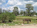
Rural scene around a mass village.

Irrigation terraces in Yunnan.

Cows grazing in the prairie of Oregon.


_(croDB2660).jpg)
Ordinance of the territory in rural Spain
If the limit of rural areas is established in municipalities with fewer than 2,000 inhabitants, there are around 5,800 municipalities in which some 3 million inhabitants would reside in Spain. The fact stands out that, in many cases, each municipality includes several districts or smaller local entities, with which the number of rural localities is greater and therefore the number of inhabitants per locality decreases.
It is worth noting the large differences in the size of human settlements in rural areas. As an example in Spain, the difference between the 327 average inhabitants per municipality in Castilla y León compared to the 864 in Andalusia (INE in 2006) stands out —among municipalities with fewer than 2,000 inhabitants. population centers the figures would vary, increasing the differences, since Castilla y León has more districts per municipality than Andalusia).
Contenido relacionado
Castries
Vermellar
Nepal