
Quetzaltenango
Quetzaltenango (Place where there are quetzals) is a city and also the capital of the Department of Quetzaltenango located in the Republic of Guatemala, noted for its remarkable historical importance and its cultural richness and recognized for being an educational city, it is also a Guatemalan tourist destination for its well-preserved Roman neoclassical architecture. It is also popularly named as "Xelajú" or simply "Xela" (pronounced as shelaju and shela, respectively).
The city is located 206 km northwest of Guatemala City in a mountainous valley in the western highlands of the country with an average elevation of 2,333 m a.s.l. no. m.. It has a population of 204,075 inhabitants but considering its metropolitan area it reaches a total of 748,174, which makes it the third most populous urban agglomeration in the country, only surpassed by the Metropolitan Area of Guatemala and the Metropolitan Conurbation of Las Verapaces, in addition Due to its importance in the sector, the city is located within the 20 most important cities in Guatemala.
Quetzaltenango has various public and private educational centers, such as some of the most renowned universities in the country. It is the city with the largest number of educational centers per inhabitant due to its strategic location, since most of its students are not from the city, but from nearby towns.
Quetzaltenango was proclaimed the Capital of Central America by the Central American Parliament in 2008. It is the head of the department of Quetzaltenango, which covers 1,953 km², equivalent to 1.8% of the national territory. In the xxi century, the municipality was incorporated into the Metropolis de los Altos Commonwealth, an entity that includes several municipalities of the departments of Quetzaltenango and Totonicapán and that promotes their sustainable development in the medium and long term.
Demographically, 53% of the population is mestizo, 45% is indigenous or Amerindian, and 2% is made up of foreigners (mostly from Mexico and Peru). Spanish is mainly spoken, while Quiché and Mam are spoken by the natives on the outskirts of the city. In the same way, Quechua is spoken among the descendants of Peruvian immigrants who settled in the city.
History
Pre-Columbian times
The current head is also mentioned in relation to common wars between the Quichés and Cachiqueles in 1552, with the name of Xelahuh that it had in the indigenous period of the time of King Quicab. The text adds that the town, formerly burned by Ah Chiyú, Ah Chi Ckix, Halic and Tabanal, it was conquered by the Zotziles and Tukuchés. In the Popol Vuh he is mentioned as Xelahuh.
Conquest
After Pedro de Alvarado killed Tecún Umán without mercy, he asked the Mexican indigenous people to accompany him: - «What is the name of the mountain?» —Tomado de Carmack, Robert (1979). The Evolution of the Quiché Kingdom. Guatemala: Society of Geography and History of Guatemala. |
Advancing along the Pacific coastal plain, Pedro de Alvarado encountered no opposition until he reached the Samalá River in western Guatemala. This region was part of the Quiché kingdom and Quiché troops tried to prevent the crossing of the river. However, the conquistadores managed to cross it and looted the nearby settlements in order to terrorize the population and discourage them from carrying out future acts of resistance. On February 8, 1524, after forcing their way across the river, Alvarado's army fought a battle at Xetulul, called Zapotitlán by its Mexican allies and now known as San Francisco Zapotitlán. Although they suffered many wounds inflicted by the Quiché archers defending it, the Spanish and their allies stormed the town and set up camp in the central plaza. Alvarado then headed back upriver into the Sierra Madre and across the pass to the fertile valley of Quetzaltenango, in the center of the k'iche' kingdom. On February 12, 1524, Alvarado's Mexican allies were ambushed at the pass and repulsed by Quiché warriors, but the ensuing Spanish cavalry charge made a deep impression on the Quichés, who had never seen horses before. The cavalry managed to disperse the indigenous troops and the Spanish approached the city of Xelajú, which they found abandoned by its inhabitants. Although the common opinion is that the Quiché prince Tecún Umán was killed in battle near Olintepeque north of Quetzaltenango, Spanish accounts make it clear that at least one and possibly two of Q'umarkaj's lords perished in heavy fighting during the initial approach to Quetzaltenango. However, according to common belief, Tecún Umán perished. during the battle of El Pinar, and, according to local tradition, died in the Llanos de Urbina southeast of Quetzaltenango, near the present-day town of Cantel.
In his third letter to Hernán Cortés, Pedro de Alvarado described the death of one of the four lords of Q'umarkaj in the vicinity of Quetzaltenango. The letter, dated April 11, 1524, was written during his stay in Q'umarkaj Almost a week later, on February 18, 1524, the Quiché army again faced Spanish forces in the Quetzaltenango Valley. The Quiché were defeated and suffered heavy losses, including many of their nobles. So high was the death toll among the native combatants that it was given the new name Xequiquel ("bathed in blood"). to Olintepeque. This battle exhausted the military forces of the Quichés, who finally sued for peace and offered to pay tribute, inviting Pedro de Alvarado to their capital Q'umarkaj. Alvarado deeply mistrusted the intentions of the indigenous people, but accepted the invitation and headed with his army to Q'umarkaj, called Utatlán Tecpán by the Spanish's Nahuatl-speaking allies.

In March 1524, Pedro de Alvarado arrived in Q'umarkaj after having accepted the invitation of the Quiché leadership after its catastrophic defeat in the Quetzaltenango valley. Although he feared a trap by the natives, Alvarado entered the city, but instead of accepting accommodation there, he preferred to set up his camp on the plain outside Q'umarkaj. Faced with the threat posed by the large number of Quiché warriors gathered outside the city and Fearing that his cavalry would not be very effective in the narrow streets of the town, Alvarado invited the highest leaders of Q'umarkaj—Oxib-Keh, the ajpop or king, and Beleheb-Tzy, the ajpop k'amha, or elected king—to visit him in his camp. As soon as they did, he seized them and held them as prisoners in his camp. When the Quiché warriors realized what had happened, they attacked the Spanish and their indigenous allies and managed to kill one of the Spanish soldiers. At this time Alvarado ordered the captured lords burned alive and, after repelling the attack, he proceeded to set the entire city on fire. After the destruction of Q'umarkaj and the execution of its rulers, Pedro de Alvarado sent messages to Iximché, the capital of the Cachiqueles, proposing an alliance to neutralize the resistance of the rest from the strongholds of the Quichés. Alvarado wrote that Iximché sent four thousand warriors to help him in his campaign, although the Cachiquel writings mention that they sent four hundred.
In October 1526, the Cachiquel king Sicanam, established in the area occupied by the modern departments of Chilmaltenango and Sacatepéquez, allied with Sequechul, deposed king of Utatlán and the Quichés and, taking advantage of a dark and rainy night, they approached to Quetzaltenango. Until then, they had been harassing the indigenous people who were already vassals of the Spanish conquistadors and brought their products to the kingdom's capital, thus disrupting its supply chain. However, that night they decided to go on the offensive.In charge of the defense of the city was Pedro Portocarrero, whom Pedro de Alvarado had left in command during a trip he had to make to Spain. Seeing the rebels, Portocarrero left ordinary mayor Hernán Carrillo in charge of defending the city and went out to face the threat with 215 Spanish soldiers, 108 horsemen, 120 indigenous Tlaxcalans, 230 indigenous Mexicans, and 4 cannons. In the ensuing battles, the Spanish forces drove the rebels back to Chimaltenango, but they in turn suffered heavy casualties and had to return to Quetzaltenango for reinforcements. Eventually, Portocarrero and his men managed to encircle Sicanam and Sequechul on top of the a hill, and after strong battles they were captured. Both kings spent fifteen years in prison until Pedro de Alvarado shipped them off to the Moluccas and was never heard from again.
In the summer of 1770 Fernando VI of Spain from the kingdom of Castilla-La Mancha sent Juan Francisco Ruid de Carrascosa y Fernández de Cámara, a native of the town of Carrascosa del Campo, to Quetzaltenango as a commissioner endorsed by the Viceroyalty of New Spain to the then hostile town. There he married a Quetzaltec woman of Spanish descent named María Josefa de Morales Molina y Ruiz de Alarcón, who in 1775 gave birth to her first-born son named Manuel María Ruid de Carrascosa y Morales, who during the Central American War of Independence In 1821, he was sent to Comitán de Domínguez, along with his wife Juana Matamoros de la Rosa and their two beautiful daughters Rita and Dominga Carrascosa Matamoros, who caused a scandal in high society when Dominga got involved with Gregorio Mariano Culebro y Urbano. husband of his sister Rita, giving birth to a son named Manuel José María Carrascosa y Culebro, who appears on the list of Governors of Chiapas on two occasions during the Porfiriato.
After the Independence of Central America

In 1825, the deputies Juan José Flores Estrada, Laureano Nova and Manuel Montúfar y Coronado, asked the Constitutional Assembly to give the title of city to the town of "Quezaltenango". This accessed through Decree No. 63 dated October 29. It should be noted that some writers later referred to the name as "Quetzaltenango", indicating that it came from the place where quetzals (Pharomachrus mocinno) abounded, based on the title of Ixquin Nehaib from 1558.
The State of Guatemala was defined as follows by the Constituent Assembly of said state that issued its constitution on October 11, 1825: «the state will retain the name of State of Guatemala and it is made up of the peoples of Guatemala, reunited in a single body. The state of Guatemala is sovereign, independent and free in its government and internal administration."
Quezaltenango was one of the original municipalities of the State of Guatemala founded in 1825; it was in the department of Quezaltenango/Soconusco, and was the head of it, together with the municipalities of Ostuncalco, San Marcos, Tejutla and Soconusco.
Sixth Estate of the Heights

On April 2, 1838, in the city of Quetzaltenango, a liberal secessionist group founded the independent State of Los Altos which sought to become independent from Guatemala. This state was made up of the modern departments of Quetzaltenango, Huehuetenango, San Marcos, Totonicapán, and Sololá—and it was where the most important Creole members of the Liberal Party of Guatemala and the liberal enemies of the conservative regime came together, who in this way no longer had to emigrate to El Salvador having a practically favorable liberal state in their country.
Liberals in Los Altos began to harshly criticize the conservative government of Mariano Rivera y Paz; they even had their own newspaper: El Popular, which contributed to the harsh criticism. In addition, there was the fact that Los Altos was the region with the greatest production and economic activity in the old State of Guatemala; without Los Altos, the conservatives lost many of the merits that sustained the State of Guatemala in the hegemony of Central America. Central American Federation did not accept it; The Guatemalan government then resorted to force, sending Army General Rafael Carrera to subdue Los Altos.
On April 14, 1838, the conservatives lost the power of the State of Guatemala, and Rafael Carrera - leader of the peasant movement - was confined to the mountains of Mita. It all began with the incursion of the liberal forces of Morazán and José Francisco Barrundia y Cepeda, who entered Guatemala and upon arriving in San Sur, executed Chúa Álvarez, Carrera's father-in-law and placed his head on a pike to punish all his followers. Upon learning of this, Carrera and his wife Petrona, who had gone out to face Morazán as soon as they found out about the invasion and were in Mataquescuintla, swore that they would not forgive Morazán even in the grave. After sending several emissaries, whom Carrera did not want to receive -especially Barrundia, to whom he informed that he was not receiving it so as not to kill him- Morazán began a strong scorched earth offensive, destroying the towns in his path and stripping them of their few assets, and forcing Carrer's forces to hide in the mountains.
Believing that Carrera was totally defeated, Morazán and Barrundia headed for Guatemala City where they were greeted as saviors by Governor Valenzuela and members of the Aycinena Clan, who even proposed sponsoring one of the liberal battalions, while Valenzuela and Barrundia put Guatemala's resources under Morazán's orders to solve any financial problems he might have. Creoles from both parties celebrated until dawn the fact that they finally had a caudillo like Morazán, capable of defeating the rebellion of field. Morazán used the resources to support Los Altos and later replaced Valenzuela with Mariano Rivera Paz, close to the Aycinena Clan, although he did not return the assets confiscated in 1829; in revenge, Juan José de Aycinena y Piñol voted to dissolve the Central American Federation in San Salvador a little later, forcing Morazán to return to El Salvador to fight for his moribund federal mandate. Along the way, Morazán increased the repression in eastern Guatemala, as a punishment for having helped Carrera, whom he considered defeated.
Knowing that Morazán had gone to El Salvador, Carrera attempted to take Salamá with his small remaining force, but was defeated, losing his brother Laureano in combat. With just a few men, he managed to flee, badly wounded, towards Sanarate. After half recovering, he attacked a detachment in Jutiapa and managed to obtain a small booty that he distributed to the volunteers who accompanied him and prepared to attack Petapa, near Guatemala City, where he triumphed, but with considerable casualties.
In September of that year, Carrera attempted an assault on the capital of Guatemala, but the liberal general Carlos Salazar Castro defeated him in the fields of Villa Nueva, and Carrera had to withdraw again to the east of the state. After several attempts unsuccessful in taking the city and Quetzaltenango, he was surrounded and wounded, he had to capitulate before the Mexican general Agustín Guzmán, who had lived in Quetzaltenango since the arrival of Vicente Filísola in 1823. Morazán had the opportunity to shoot him, but he could not because he needed the support of the Guatemalan peasantry to be able to counteract the attacks of Francisco Ferrera in El Salvador; instead, they named him as military chief of Mita, but without weapons.In Mita, he received a notice from Francisco Ferrera to meet, to which he agreed; Knowing that Morazán was going to attack El Salvador, they decided that Carrera was going to attack Guatemala City and for them Ferrera gave him a thousand weapons and ammunition.
Meanwhile, despite the recommendations of those close to him to definitively crush Carrera's forces, Salazar tried to negotiate with him through diplomatic channels. Even to show Carrera that he was neither feared nor mistrusted, he withdrew the fortifications that had been in the Guatemalan capital since the battle of Villa Nueva.
Taking advantage of Salazar's good faith and Ferrera's arms, on April 13, 1839 Carrera took the Plaza de Guatemala by surprise; Salazar Castro, Barrundia and Mariano Gálvez fled before Carrera's arrival; Salazar, in a nightshirt, jumped off the roofs of neighboring houses and sought refuge. Later, as he could, he crossed the border disguised as a peasant and fled Guatemala.Without Salazar, Carrera reinstated Mariano Rivera y Paz, as governor of Guatemala; Rivera Paz in turn appointed him General in Chief of the Army although in reality it was Carrera who had absolute command.

In February 1840, Carrera defeated General Agustín Guzmán and then entered Quetzaltenango, where he imposed a conservative regime that was harsh and hostile to the people of Alta in retaliation for having tried to form a liberal state. Calling all the members of the council, he emphatically told them that he was kind to them because it was the first time they had challenged him, but that he would have no mercy if there was a second time. Finally, General Guzmán, and the head of the State of Los Altos, Marcelo Molina, were sent to the Guatemalan capital, where they were exhibited as war trophies during a triumphant parade on February 17, 1840; in the case of Guzmán, shackled, with still bleeding wounds, and mounted on a mule.

He tried to invade Guatemala for the second time in 1840 after having invaded in 1829 and expelled the members of the Aycinena Clan and the regular orders. In 1840 he was beaten by Carrera in an overwhelming manner, marking the end of his career in Central America.
On March 18, 1840, when Morazán was the Liberal head of State of El Salvador, he invaded Guatemala with fifteen hundred soldiers to avenge the outrage done to the defeated in Los Altos and fearing that this action would put an end to the Liberal efforts to keep the Central American Federation together. Similar to his first invasion in 1829, he reached Barberena virtually unmolested. Guatemala had a cordon of vigilantes from the border with El Salvador; In the absence of a telegraph, the men ran carrying last-minute messages.With the information from these messengers, Carrera hatched his defense plan, leaving his brother Sotero in charge of troops that would present a slight resistance in the city.
Carrera pretended to flee and led the improvised army to the heights of Aceituno since he only had about four hundred men and the same number of rifle charges, plus two old cannons. The city was left at the mercy of Morazán's army, with the bells of its twenty-two temples tolling for divine help. Once Morazán reached the capital, he easily took it and freed Guzmán, who immediately left for Quetzaltenango to deliver the news that Carrera was defeated; Carrera then, taking advantage of the fact that the enemies believed they were victorious, applied a concentration of fire strategy in the city's Central Park and complemented it with the surprise attack tactic with which he caused heavy casualties to Morazán's army to, finally, forcing the survivors to fight hand-to-hand. Already in such a combat scenario, Morazán's soldiers lost the initiative of the attack and their numerical superiority. In addition, they did not know the city in which they were fighting and they had to fight and carry their dead and attend to their wounded when they were still tired from the long march from El Salvador to Guatemala.
In such a way that Carrera, by then already an experienced military officer knew how to stand up and battle Morazán until he defeated him withering, to the point that he, helped by Ángel Molina who knew the alleys to the west of the city, had to flee with their favorites in disguise and shouting "Long live Carrera!" through the Incienso ravine towards El Salvador, to save his life.In his absence, Morazán had been relieved of the position of Head of State of that country, which is why he had to embark for exile in Peru.
In Guatemala, the surviving Salvadorans were mercilessly shot, while Carrera was out in pursuit of Morazán, whom he failed to catch up with. This incident definitively sealed the status of General Carrera and marked the decline of Morazán.
Meanwhile, Guzmán arrived in Quetzaltenango with the news that Morazán had triumphed in the city of Nueva Guatemala de la Asunción, and the city's liberal Creole elite once again declared the State of Los Altos in force. Carrera sent the Salvadoran military Francisco Malespín to notify the K'iche' and K'achi'kel to prepare again to fight the Quetzaltec creoles, and then he left for Quetzaltenango determined to punish the Altense liberals. Upon hearing this news, most of the members of the council fled and the few that remained wanted to retract and apologize for having tried to form the state again. But while the indigenous people of the region persecuted the criollos who fled, Carrera arrested to the members of the council that had remained and then ordered them to be shot -in front of the extinct Banco de Occidente- despite the fact that the Altense population murmured «Massacre! Massacre!" As a result, the liberal criollos were weakened and diminished, and the capital's conservatives frightened; but the indigenous populations of Quetzaltenango realized that they had a strong ally in Carrera.
When Carrera returned to Guatemala to attend to his dying mother, the liberals of the capital fled and fear seized the conservatives of the Aycinena Clan, since it was clear that, had Carrera wanted to, he could have carried out the indigenous revenge and annihilate all whites. The only thing that prevented a new massacre was the fact that Carrera needed money from the Aycinena Clan to pay his troops.
Liberal governments
After the Liberal Reform of 1871, a series of liberal governments began. In 1884, the Appleton publishing house of New York published in English a guide to Mexico and Guatemala, in which some engravings of Quetzaltenango were presented:


Quetzaltec Revolution of 1897


In December 1896, Enecón Mora, from La Ilustración Guatemalteca described how people lived in Quetzaltenango. Commerce was highly developed, and luxury and wealth were increasing among the inhabitants; retail trade was in the hands of Chinese and Jewish immigrants, while high-end trade was represented by the Ascoli, Meyer, Maegli, Stahl, Zadik and Vizcaíno houses, among others. from Banco de Guatemala, Agrícola Hipotecario and Internacional. On the other hand, the entire city and many public and private buildings were illuminated with electric light and the population had two hundred and fifty telephones; both services were efficient and had been introduced by the house of Juan Aparicio.
By 1896 there was already the Faculty of Law and Notaries of the West, and for secondary and normal schools there were two institutes for students of both sexes; there was also a School of Arts and Crafts and a night school for craftsmen. Finally, there were many primary and elementary schools. The Hospital of San Juan de Dios was, after the one in Guatemala City, the best in the Republic for its size.
In 1897, due to the economic crisis derived from the beautification of the infrastructure and the failure of the Central American Exposition, President José María Reyna Barrios began to save on education, closing the schools, and later extended his term for another four years.
The forced extension of the Reyna government created discontent among the Guatemalan population, who realized that the ruler's intentions were no longer solely the progress of the country. Protests took place and on September 7, insurgents led by former minister Próspero Morales took over the barracks and public offices in San Marcos and marched towards Quetzaltenango with an improvised army made up of workers, merchants and professionals. The leaders of the movement, Juan Aparicio, Jr. (wealthy philanthropist), and Sinforoso Aguilar (first mayor of Quetzaltenango), were betrayed by a supposed friend and handed over to soldiers loyal to Reyna Barrios. The President ordered them to be shot on September 13 without prior trial.
The Quetzaltec society pleaded with the president that the condemned men not be shot, to which Reyna Barrios finally agreed and asked her Minister of the Interior, Manuel Estrada Cabrera, to telegraph the message. The Minister -who was also from Quetzaltenango and had a personal dispute with Aparicio- delayed sending the telegram, which reached its destination after Aparicio's death. Apparently, Estrada Cabrera had a personal problem with Aparicio for failing to take over the Quetzaltenango Electric Company, and he took advantage of the circumstance to eliminate him. Realizing this, Reina Barrios sends Estrada Cabrera to Costa Rica on a diplomatic commission; Upon returning from that country, Estrada Cabrera was removed as Secretary of the Interior.
Aparicio and Aguilar and about two hundred of those who fell in the battle of Quetzaltenango, were buried in a common grave in the Quetzaltenango cemetery known since then as the "Pantheon of Martyrs."


San Perfecto earthquake
The San Perfecto earthquake occurred on April 18, 1902 at night and had an estimated magnitude of Mw 7.5 in the department of Quetzaltenango. The earthquake lasted 1 to 2 minutes and was preceded by several premonitory earthquakes and followed by many aftershocks. Between 800 and 900 died from the earthquake and there was significant material damage in the extensive area affected. All churches in western Guatemala and eastern Chiapas were severely damaged or destroyed.


After the death of his mother in the earthquake, the Quetzaltec composer Mariano Valverde was inspired to create his melody "Noche de Luna entre Ruinas." For his part, the German engineer Edwin Rockstroh, professor of sciences and mathematics at the then prestigious National Central Institute for Men in Guatemala City, wrote a technical article on the earthquake in the journal Nature.
Eruption of the Santa María volcano in 1902


1902 was a tragic year for Quetzaltenango: it was just recovering from the April earthquake, when the Santa María volcano erupted on October 24 of that same year. The volcano had been dormant since the Spanish conquest in 1524 and with Its almost perfect cone, 3,768 meters high, was a scenic setting for the Quetzaltec city. The eruption was even more devastating than the earthquake, since it also caused extensive damage to surrounding farms and villages and there are accounts that the sand and ash reached the Chiapas region of Mexico. It is estimated that the catastrophe caused five thousand deaths and thousands of pesos in agricultural and material losses.
The volcano's eruption released a column of material that reached 28 kilometers in height and formed a dark cloud that covered the sunlight for several days. The eruption lasted 36 hours and formed a large crater in the southwestern flank of the mountain, forming the Santiaguito volcano.
| Day | Time | Success |
|---|---|---|
| 24 October | 5:00 p.m. | It was heard in San Felipe a frightening noise resembling the whisper of a huge waterfall for 5 minutes on the side of the volcano; but nothing could be seen because of the much fog. |
| 24 October | 6:00 p.m. | Pomez stone sands fell in Quetzaltenango shortly after ash |
| 24 October | 7:00 p.m. | Lightning and clarity were seen, and a sound like a high oven flame was heard. |
| 24 October | 8:00 p.m. | It was noticed from San Felipe a gigantic column of black ashes with a multitude of spinning torbellins ferociously, crossed by thousands of rays and curved lines of green or red light. The entire volcano and its surroundings trembled continuously and huge detonations were heard up to 160 kilometers away; the strong winds carried with it most of the loose matter of the eruptive column at distances of 800 and more kilometers; a part was carried by higher winds to the North, and in a large extension reigned for whole days absolute darkness. |
| 25 October | 1:00 a.m. | The violence of the eruption increased and began to fall to distances of 14 kilometers from the volcano solid rocks of small and medium sizes and pierced the foils of the neighboring roofs with so many holes, that finally resembled to colanders. |
| 26 October | 12:00 a.m. | The rage of the volcano calmed down. |
| 26 October | 3:00 p.m. | There was an eruption whose cloud was mostly white and it was likely that it consisted mainly of water vapor. |


In the midst of the commotion, the Political Headquarters and the Municipal Corporation were in charge of organizing the immediate resources available to help the victims, organizing the help coming from the neighbors who could provide it and managing it to the government of the capital. In Guatemala City, President Estrada Cabrera and his cabinet were busy organizing the Minerva festivities. His response to the catastrophe was to reduce it and, in the worst case, try to silence it by preventing the media from disclosing the dimensions of the catastrophe in the western region of the country.
In the United States, the first detailed reports of the eruption did not appear until November 13, 1902, when both the San Francisco Call and the San Francisco Chronicle presented accounts of victims who had arrived from Guatemala on barges.
The official response of the central government to the Quezalteca authorities was to declare that public funds were not available, since they had recently been used to help that same city, for those affected by the earthquakes in April, for which reason it was impossible to attend to the request. In such circumstances, the mayor of the city, in an extraordinary session, informed all the members of the council that as a result of the eruption the pastures and crops of the "western area of the Republic" were they went bankrupt, so a shortage of basic grains was to be expected at that time, especially affecting low-income people. For this reason, the municipal corporation decided that two hundred pesos would be invested in the purchase of food to be distributed among the most needy. Likewise, the cattle of the haciendas were perishing. Losses began to be reported, not only due to the disappearance of the herds but also due to the lack of cattle to supply the city's butcher shops. Given the food shortage in the region, the municipal council made the decision to request the central government – which was approved – for authorization to import two thousand quintals of flour free of tax, up to ten thousand, during the following months.
The councilor for supplies of the municipality was in charge of administering the aid for the victims coming not only from the residents of Quetzaltenango but from all that was expected to arrive from the capital and other departments. The supply of drinking water was another immediate problem; The city plumber carried out an inspection of the aqueduct that supplied the city the day after the eruption, reporting no damage to it, but due to the complaints of the neighbors due to the lack of the vital liquid, subsequent inspections indicated that the pipes they were clogged by the large amount of ash and sand that the volcano had thrown up.
The population was affected in vast ways: for the indigenous people it was truly catastrophic, not only because they lost relatives and friends, their homes and crops, but they were also forced to work in the reconstruction work. For their part, the landowners saw the opportunity to compensate for the damages by obtaining other lands and so requested President Estrada Cabrera, who gave them land in San Miguel Uspantán in Quiché and in Panama in Suchitepéquez and Sololá, which until then had been been community lands of the indigenous people of the region.

Reconstruction of the City
The city was severely damaged, for that reason expansion began towards the peripheries known as "la ciénaga" and "democracy" which today are zones 2 and 3, if the new Quetzaltenango plan began with the help of the engineer Francisco Vela who drew the perfect grid of the La Democracy neighborhood and which ended up to 25th avenue. The city center changed from large colonial-style houses to give way to the construction of Europeanist buildings with the help and influence of a group of Italians led by the architect Alberto Porta, who was responsible for great monuments such as the Enríquez Passage, the Metropolitan Cathedral, the current park at Central America, among others. The innovation and growth of Quetzaltenango took a big step when the first and only electric railway in Guatemala was built and the second in America at the time; the Los Altos Railroad and its central station were located in the current intercultural center. In addition to building one of the first talkies in Central America; the Roma theater and which was the largest room in Guatemala until the construction of the Miguel Ángel Asturias Cultural Center in 1978.
Second half of the 20th century

From 1950 to 1964, more industrial factories were established, along with the Cantel and Capuano factories, which already existed. The establishment of the Cervecería Nacional and the Embotelladora Nacional helped to form the economic structure that was drawing what would later be the metropolis of the West and the second city of the country.[citation required]< /sup>
In the 2010s, Quetzaltenango became a strategic place for commerce, services and education, as well as for the textile and liquor industry nationwide. Another sector that has had an interesting upturn in the city is the construction sector, since the construction services industry has proliferated, due to the increase in shopping centers, neighborhoods, and condominiums. Many of the companies established in the country's capital have set their sights on the city of Quetzaltenango as an investment center, which is why the city's economy is growing rapidly.
At the rate of two new developments per month, and with nine universities, the forecasts of the Secretariat of Planning and Programming of the Presidency (SEGEPLAN) indicate that in 2032 it will have more than 2 million 300 thousand inhabitants.[ citation required]
21st century: Los Altos Metropolis Commonwealth
This entity was formed in the xxi century, has a territorial extension of 871.06 km² and is made up of a total population of 364,258 inhabitants. The Commonwealth is made up of the municipalities of San Andrés Xecul and Totonicapán in the department of Totonicapán and by the municipalities of San Carlos Sija, Sibilia (Quetzaltenango), La Esperanza, San Juan Ostuncalco, Quetzaltenango, Zunil and Salcajá in the department of Quetzaltenango. who joined the entity voluntarily. The municipalities are represented through their Municipal Councils and "promote the local, integral and sustainable development of the member municipalities through the formulation of municipal public policies, plans, programs and projects, the execution of works and the efficient provision of the services within its competence, individually and jointly”.
Physical geography
Climate

According to the Köppen climate classification, Quetzaltenango has a temperate sub-humid mountain climate (Cwb). In general, the weather in Quetzaltenango can range from temperate to cold, with sporadic and occasional warm days. The daily maximum is usually reached around noon, thereafter temperatures drop exceptionally fast. Quetzaltenango is one of the coldest cities in Guatemala.
The city is quite dry, except during the rainy season, due to this, two marked storms are recognized and with a high rainfall differential, the rainy season that runs from mid-May to mid-November, where normally, the months the rainiest are June and September. And the dry season, which goes from mid-November to mid-May. It is worth mentioning that during the rainy season, the rain is constant and generally falls in the afternoon.
The coldest months are from November to February, with minimum temperatures of 4 °C and maximum temperatures of 22 °C. It is somewhat common that in the winter months there are frosts in the urban area within the city center, which can drop to -2 °C and −4 °C in peripheral areas.
The hottest months are from March to July, with minimum temperatures of 8 °C and maximum temperatures of 23 °C.
The last days of spring see the highest temperatures, sometimes exceeding 26 °C.
Annually, the average minimum is 6 °C and the average maximum is 22 °C.
The minimum temperature record was reached in February 2002, when it dropped to -11 °C, while in the neighboring mountainous municipality of Olintepeque, the absolute minimum dates from 1984, with -14.2 °C, the maximum by counterpart it was 29.8 °C.
| Month | Ene. | Feb. | Mar. | Open up. | May. | Jun. | Jul. | Ago. | Sep. | Oct. | Nov. | Dec. | Annual |
|---|---|---|---|---|---|---|---|---|---|---|---|---|---|
| Temp. max. abs. (°C) | 28.4 | 29.8 | 29.8 | 28.2 | 29.4 | 26.5 | 25.2 | 25.0 | 26.0 | 25.2 | 25.6 | 26.2 | 29.8 |
| Average temperature (°C) | 22.0 | 23.5 | 25.5 | 23.8 | 23.1 | 21.9 | 21.9 | 22.1 | 20.9 | 21.7 | 21.3 | 22.1 | 22.5 |
| Average temperature (°C) | 12.9 | 13.7 | 14.8 | 15.8 | 15.8 | 15.6 | 15.8 | 15.8 | 15.2 | 15.0 | 14.0 | 13.2 | 14.7 |
| Temp. medium (°C) | 2.3 | 2.9 | 3.9 | 6.3 | 8.8 | 9.3 | 8.2 | 8.5 | 9.0 | 8.4 | 6.0 | 2.8 | 6.4 |
| Temp. min. abs. (°C) | -11.5 | -5.4 | -5.2 | -3.6 | 0.6 | 1.0 | 2.5 | 0.5 | 1.0 | 0.0 | -5.5 | -5.4 | -11.5 |
| Total precipitation (mm) | 1.80 | 5.50 | 14.44 | 41.16 | 131.55 | 147.77 | 98.65 | 106.95 | 134.67 | 93.55 | 18.68 | 7.08 | 801.8 |
| Days of precipitation (≥) | 0.80 | 0.93 | 2.33 | 5.87 | 16.80 | 21.93 | 6 p.m. | 17.53 | 22.80 | 14.47 | 5.67 | 2.13 | 129.3 |
| Hours of sun | 249.57 | 240.27 | 249.33 | 212.77 | 167.14 | 142.32 | 185.27 | 187.51 | 135.61 | 156.94 | 199.15 | 228.69 | 2354.6 |
| Relative humidity (%) | 65.68 | 63.05 | 64.50 | 68.40 | 74.50 | 79.37 | 74.47 | 76.05 | 81.16 | 79.32 | 72.65 | 68.63 | 72.3 |
| Source: National Institute of Seismology, Vulcanology, Meteorology and Hydrology (INSIVUMEH) | |||||||||||||
Geographic location
Quetzaltenango is surrounded by municipalities of the department of Quetzaltenango, except to the north where it borders San Andrés Xecul, of the department of Totonicapán.
| North: San Mateo, La Esperanza and Olintepeque San Andrés Xecul, municipality of the department of Totonicapán | ||
| West: Concepción Chiquirichapa |  | This: Zunil, Almolonga, Cantel and Salcajá |
| South: El Palmar y Zunil | Sureste: Zunil |
Municipal government
Municipalities are regulated by various laws of the Republic, which establish their form of organization, matters relating to the conformation of their administrative bodies, taxes earmarked for them; this legislation is dispersed at various levels. However, the fact that there is specific legislation for municipalities does not mean that the rules contained in other regulatory bodies are not applicable to them, because although they are autonomous entities, they are subject, like all entities of this nature. to national legislation.
Specifically, the main laws governing municipalities in Guatemala since 1985 are:
| N.o | Law | Description |
|---|---|---|
| 1 | Political Constitution of the Republic of Guatemala | It is applicable to several general articles of the same, and also has a specific legal regulation in articles 253 to 262, which constitute its constitutional basis. |
| 2 | Electoral and Political Parties Act | Constitutional law created by the National Constituent Assembly that applies to municipalities in various aspects but mainly in the subject of the formation of their elected authorities, since it regulates the manner in which they are chosen and formed. |
| 3 | Municipal Code | Decree 12-2002 of the Congress of the Republic of Guatemala. It has the ordinary category of law and contains general provisions applicable to all municipalities, and even contains legislation concerning the creation of municipalities. |
| 4 | Municipal Service Act | Decree 1-87 of the Congress of the Republic of Guatemala. It regulates relations between municipalities and public servants in the field of work. It has its constitutional basis in article 262 of the constitution that orders the issue. |
| 5 | General Decentralization Act | Decree 14-2002 of the Congress of the Republic of Guatemala. It regulates the constitutional duty of the State, and therefore of the municipality, to promote and apply decentralization and economic and administrative deconcentration. |
The government of the municipalities of Guatemala is in charge of a Municipal Council, in accordance with article 254 of the Political Constitution of the Republic of Guatemala, which establishes that "the municipal government will be exercised by a municipal council". In turn, the municipal code —which has the character of ordinary law and contains provisions that apply to all municipalities in Guatemala— establishes in its article 9 that "the municipal council is the superior collegiate body for deliberation and decision on matters [...] and has its seat in the constituency of the municipal seat". Finally, article 33 of the aforementioned code establishes that "[t]he exercise of municipal government corresponds exclusively to the municipal council".
The municipal council is integrated in accordance with what the Constitution establishes in its article 254, that is to say «it is integrated with the mayor, the trustees and councilors, directly elected by universal and secret suffrage for a period of four years, being able to be re-elected". In this regard, the municipal code in article 9 establishes "that it is made up of the mayor, trustees and councilors, all directly and popularly elected in each municipality in accordance with the law on the matter".
There are also Auxiliary Mayor's Offices, Community Development Committees (COCODE), the Municipal Development Committee (COMUDE), cultural associations and work commissions. The auxiliary mayors are elected by the communities according to their principles, values, procedures and traditions, they meet with the municipal mayor on the first Sunday of each month. The Community Development Committees and the Municipal Development Council have the function of organizing and facilitating the participation of the communities, prioritizing needs and problems as well as seeking solutions to them.
Economy

Commercial, service, educational (primary, secondary, and university), social, political, governmental, and cultural aspects, among others, attract many people from nearby places and other departments, which is why Quetzaltenango is becomes a city that concentrates commerce and services in the west of the country.
The city also has a wide variety of restaurants, shopping centers, squares, avenues, hotels, and shops that are mainly focused on zones 1, 3, and 9. It has an economically active population according to census data conducted by the INE (2,002), projected for the year 2009 amounts to a total of 54,512 people (representing 37.43% of the total population), of which 35,367 are men and 19,145 are women.
Among its crops, the following stand out: coffee, corn, apple, broccoli, lettuce, African palm, sesame, rice and rubber. It is a livestock, industrial area, with great commercial and service activity.
The department is characterized by having tourist attractions such as: Cerro del Baúl (nature reserve), Cerro Siete Orejas, Cerro Quemado, the baths of Almolonga Cirilo Flores, Las Delicias, Fuentes Georginas (hot springs), the Lagoon de Chicabal and others, which offer ecological and adventure tourism, which has determined that the number of tourists has increased in recent years.

Tourism is important for Quetzaltenango since it is in the city where the excursions to the different destinations offered by the department leave, there are companies that offer travel packages and tour guides, making the city an important visiting point for tourists.
Quetzaltenango organizes an annual fair called the Central American Independence Fair, held from September 12 to 18 in honor of national independence. In this fair you can find mechanical games, the sale of traditional Guatemalan and international food and shops of different categories, beauty pageants, concerts in different parts of the city, social parties and parades that highlight the importance of the event. being the most important day September 15, which commemorates the independence of Guatemala, in addition to a series of different civic activities throughout the month. On such dates an artistic contest is held where writers are awarded at a national level.
On October 7 of each year, it is celebrated with great religious fervor, the day of the Virgen del Rosario, Patron Saint of the Municipality, which includes celebrations throughout the month, being a very special date for the inhabitants who profess the Catholic faith of the municipality.
Quetzaltenango is classified as the cradle of culture in western Guatemala. Important national and international artists, musicians, painters and athletes were born in the city.
Tourism
The city of Quetzaltenango is currently one of the most important tourist destinations in Guatemala, this due to its culture, gastronomy, climate and its works of neoclassical architecture in its Historic Center. Xela, like the colonial city of Antigua Guatemala, are centers of domestic and international tourism. 77% of foreign tourists who enter the city of Alta do so by land through the Inter-American highway and 33% by air using the Quetzaltenango International Airport. 58% of tourists in the city are men and 42% women, mainly between 26 and 35 years of age. According to the Guatemalan Tourism Institute, the months of the year in which the city receives the most tourists are January, June, July, August and September and the average tourist stay is 5.49 days within the city. 59% of tourists stay in the city's hotels while the rest stay at a relative's house or use the Airbnb application.

Tourism in the city has developed since 1892 when the first hotel in Quetzaltenango opened its doors to accommodate visitors to this city, who began to arrive for cultural and business reasons. In 1935, the second hotel that is currently still active was opened. In addition, since the eighties, another type of tourism began to gain strength with the main objective of learning Spanish as a foreign language, with this opening opportunities for the opening of other tourist businesses that complete the existing supply and demand. The city currently offers multiple attractions and services that satisfy the different travel motivations, including culture, ecotourism, adventure, health, conventions, among others. Starting in 2013, the Guatemalan Tourism Institute launched the tourism brand "Vive Xela" which has raised domestic and international tourism in the city and its surroundings. The history, live Mayan culture, ancestral customs, gastronomy, accent neutrality for learning the Spanish language, as well as the volcanoes and hills motivate national and foreign visitors to visit it, for all these aspects that characterize the city it was proclaimed in 2008 as Capital of Central America by the Central American Parliament. Quetzaltenango is part of the tourist region of the highlands of Guatemala, this region is made up of the departments of Quetzaltenango, Totonicapán, Sololá, the northern part of San Marcos, Huehuetenango, Quiché and Chimaltenango. This region is notable for its rich pre-Hispanic and colonial history, visitors have the opportunity to appreciate the most deeply rooted Mayan culture in the country, as well as enjoy nature, landscapes, crops, forests, hot springs, and volcanoes. In this area of Guatemala there is also a high demand in the trade of handicrafts, hiking, canopy, among others.

Among the main tourist attractions of Quetzaltenango, the Historic Center of the city, the Santiaguito volcano, the Santa María volcano, the Cerro Quemado volcano and the Siete Orejas volcano stand out. The city is the starting point to visit the tourist attractions of the region, due to its wide range of main and complementary services found in the city, such as the Historic Center, museums, convention centers, among others.
Tourist attractions of the city

| No. | Description | ||||||||
|---|---|---|---|---|---|---|---|---|---|
| 1 | Historic City Centre | ||||||||
| 2 | History of Quetzaltenango and the Sixth State of the High | ||||||||
| 3 | Museum of Natural History | ||||||||
| 4 | Altos Railway Museum | ||||||||
| 5 | Museum of the Ixquic indigenous costume | ||||||||
| 6 | Traditional gastronomy | ||||||||
| 7 | Costume of the Blessed Child / Intangible Cultural Heritage of the Nation | ||||||||
| 8 | Chapels of the Virgin of the Rosary | ||||||||
| 9 | Festivals in neighborhoods in honor of the patron | ||||||||
| 10 | Mayan sacred sites | ||||||||
| 11 | Craft workshops of fabrics and chocolate processing | ||||||||
| 12 | Mayan culture and language K’iche’ | ||||||||
| 13 | Traditional dance groups and convites | ||||||||
| 14 | Schools of art | ||||||||
| 15 | Statues and monuments | ||||||||
| No. | Description | ||||||||
| 1 | Ecotourism in the Santa Maria Volcano | ||||||||
| 2 | Ecotourism in the Santiaguito Volcano | ||||||||
| 3 | Ecotourism in Cerro El Baúl with city views | ||||||||
| 4 | Ecotourism in Cerro Quemado Volcano | ||||||||
| 5 | Ecotourism in the Seven Ears Volcano | ||||||||
| No. | Description | ||||||||
| 1 | Holy Week Traditions | ||||||||
| 2 | Independence parties | ||||||||
| 3 | Patron Festival in honor of the Virgin of the Rosary | ||||||||
| 4 | Celebration of the Day of Saints | ||||||||
| 5 | Poetry Festival | ||||||||
| 6 | Jazz Festival | ||||||||
| 7 | Central American Floral Games | ||||||||
| 8 | Film Festival | ||||||||
| 9 | Chocolate Festival | ||||||||
| 10 | Sports Club Xelajú MC | ||||||||
Origin of foreign visitors
| Country of Origin | % of tourists visiting the city | |
|---|---|---|
| 27 | ||
| Europe | 20 | |
| 11 | ||
| 10 | ||
| 7 | ||
| 6 | ||
| 4 | ||
| 4 | ||
| 4 | ||
| 3 | ||
| 3 | ||
Football Team «Xelajú Mario Camposeco»
The “Xelajú Mario Camposeco” Social and Sports Club is the most important soccer club in Guatemala at the departmental level. The team, which was named in honor of the late soccer player Mario Camposeco, who tragically died in a plane crash in the 1960s, is the third largest team in Guatemala, behind only the Guatemala City Municipal and Comunicaciones teams. It is the only Major League Soccer team in the city of Quetzaltenango after Balbolan and Rosario FC disappeared.
His fans stand out as one of the most important both in Guatemala and Central America. In its historical development there have been several groups which have been called: La Barra del Tigre, La Ultra Goats, La Barra Extranjera, La Curva del Diablo and La Bulla. The latter was formed in the year 2000, which revolutionized the support of the Team and introduced many radical changes to encourage the Club, which still exists but many of its members left it and now its number is reduced. Another of the most iconic bars that support the Superchivos is La Curva, its name is because it is located in the North general curve, it had its greatest peak during the championship obtained in the 1997-1998 season. Currently the largest bar is La Barra del Sexto Estado and/or La Gloriosa 63, which is located in the south general, which is credited with having made the first Tifo in Central America when the 75th anniversary of the Club was celebrated. in the year 2017.
News


Currently, the city of Quetzaltenango ranks second among the most important urban conurbations in Guatemala and ranks 17th according to the ICL of FUNDESA with a result of 61.32 points, highlighted by the large number of schools, colleges, hospitals and universities, today being the cultural center of the western part of the country. Likewise, in the city there are a large number of Spanish schools, attended by people from many countries of the world, mainly from Mexico and the United States. The education of Spanish as a second language is provided with ecological excursions and adventure tourism. Today the city also has nightlife, concentrated in part of its historic center, where you can taste national and international food and drink, in its various restaurants, bars and nightclubs, and in many municipalities of this department there are shops crafts with a wide variety of craft items.
The city continues to be a pole of attraction for immigrants from rural areas of the country, as well as foreign immigrants, mostly from southern Mexico and Central America.
The city was declared an emerging and sustainable city in July 2013 by the Inter-American Development Bank.
Sectors with the greatest presence today

The city of Quetzaltenango is currently one of the most outstanding cities in the country due to its wide levels of commerce, education, tourism and culture. Regarding the commercial and industrial sector, this city stands out for its high performance due to its economic activity and high levels of production and marketing in terms of the textile industry and the liquor industry. The education and tourism sector has had an increase in its levels of development in recent years.
The Quetzaltec territory also has a large number of resources that, converted into capitals, make said city an area with a high quality of life:
- Human Capital: Mostly young citizens and entrepreneurs with a wide export of talents.
- Financial capital: Head of the second department with the largest financial mobility in the country
- Institutional Capital: 36 public institutions, 4 consular bodies, 28 NGOs recognized in the city and institutions of departmental incidence.
- Capital Infrastructure: Quetzaltenango has the third best infrastructure index in the country only surpassed by Guatemala and Sacatepéquez.
- Cultural Capital: City named as the Central American Capital of Culture by the Central American Parliament, is a cultural venue where multiple groups potentialize local culture.
- Sports Capital: Multiple disciplines, including cycling, athleticism and its highest manifestation, the Sports Club of football have highlighted athletes and citizens at national and international levels.
- Education Capital: One of the city's main engines, the high rate of education coverage, the wide presence of public/private establishments and universities position the city as an educational center.
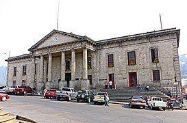
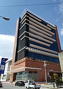
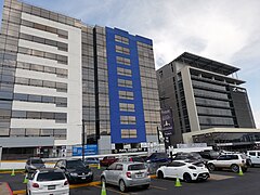
- New and modern buildings and structures of Quetzaltenango
Municipal Palace.
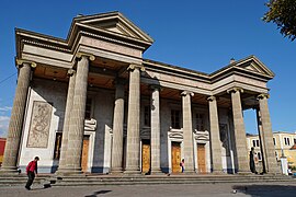
Municipal Theatre.

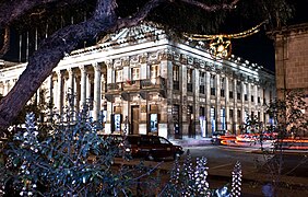
Pasaje Enriquez.

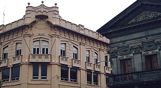
Building in Historic Centre.
Rivera Building.

Old building in the Historic Center.
Quetzaltenango Cathedral.
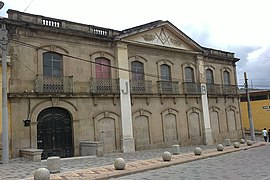
Freemason building in Quetzaltenango.

Temple of Minerva.
Building of Culture.

Arch of the Sixth State of Los Altos.

Latam and Pradera Xela.

Royal Xela Walk.

Latam Hotel.
Utz Ulew Mall.
Torres Pradera Xela.


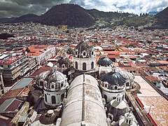
Panorama of the city of Quetzaltenango


Transportation
Los Altos Railroad
During 1930 and 1933, the city of Alta had the Los Altos Railroad railway system that connected the city with the municipality of San Felipe. The financing of the railway was US$ 20 million (at that time), money in gold, which was given by the Guatemalan government, however due to the rainy season in Santa Marta the roads were destroyed and due to the onset of the Great Depression the system was discontinued. Currently, the melody "Ferrocarril de los Altos" by the Guatemalan composer Domingo Bethancourt is known nationally.
Aerial

The Quetzaltenango International Airport operated by the General Directorate of Civil Aeronautics of Guatemala is located northeast of the city in the country's highlands and is the fourth largest airport in Guatemala. The Airport has commercial flights to the La Aurora International Airport located in Guatemala City and to the Mundo Maya International Airport in the city of Santa Elena de la Cruz, as well as charter flights to the Puerto Barrios Airport in the City of Puerto Barrios and to the Cobán airport serving the cities of Cobán and San Pedro Carchá.
Buses

The “Minerva” Bus Terminal is the largest and busiest in the city since hundreds of buses from different cities and municipalities of the Guatemalan highlands and dozens of pullman buses from Guatemala City enter every day. Quetzaltenango, being a tourist city, is visited by Guatemalans and foreigners, so it is also common to see a high number of private tourist buses.
Road
The city of Quetzaltenango is the central point of multiple highways that connect it with other municipalities in the departments of Quetzaltenango and Totonicapán, such as highway RN-1 and Autopista Los Altos, highway RN-09S that connects the city with the fertile valley of Almolonga and the tourist municipalities of the Department of Retalhuleu, Quetzaltenango is also connected to the rest of the country's cities through the Inter-American highway located to the north of the City.
Culture


The city of Quetzaltenango, like the cities of Antigua Guatemala and Guatemala City, stands out for its commitment to culture and traditions that has led it to be named the "Cradle of Culture", a sample of this is that in each of the main entrances to the city an emblematic monument is located as a welcome to its visitors. Historically, it has been the home of great musicians, poets, sculptors and many internationally recognized artists, highlighting among them: Efraín Recinos, Rodolfo Galeotti Torres, Jesús Castillo, Rodolfo Robles Valverde, Werner Ovalle López, Domingo Bethancourt, Wotzbelí Aguilar and Mariano Valverde. among others. The architecture of the city is also a clear example of culture due to its monumental neoclassical architectural works, its colonial layout and its stone streets and bridges along with emblematic monuments that make visiting the city a journey through the history of Guatemala, the The city is also home to a large number of financial, cultural, and state buildings and has a wide gastronomic offer and nightlife. There are several museums and cultural centers in various parts of the city where you can appreciate the historical, archaeological, artistic, traditional and cultural wealth.

In the city there are also a large number of Mayan altars and ceremonial centers that highlight the importance of the roots of the ancient Mayan culture. In the city, apart from the Spanish language, two Mayan languages are still spoken, K'iche and Mam, and there are schools with the purpose of learning and practicing these languages. These schools are usually frequented by local citizens and foreigners who visit the city. In the city and its surroundings there are a large number of official Spanish schools, professional teachers specializing in different vocabularies such as medical, legal, commercial, among others, leading the city to be recognized as an educational center in the highlands of the country.
Traditions and events
Among the most notable traditions in the city are the Holy Week processions, the Central American Independence Fair, and the craft fair in Parque Centroamérica. Quetzaltenango is also a highly sought after destination for holding events, as it has a large number of halls, gardens, hotels and services that adapt to the needs of any activity such as weddings, parties, congresses, conventions, workshops and training. Large-scale political events have been held in the city with the help of the Convention Bureau, whose purpose is to organize the events and link the available service options in order to carry out these activities in the most appropriate manner.
At the movies
Here I stay
The film Here I Stay by Guatemalan director Rodolfo Espinoza Orantes and starring Carlos Hernández, Andrés Zea and Beatriz del Cid, was filmed in Quetzaltenango and shows numerous representative places of the city; among them: the Municipal Theater, the general cemetery of the town, the church of San Juan de Dios, the Zunil tunnel, the Centennial Arch of the 1897 revolution, Cerro Quemado, the Central Park, and the canteen "La Tejana". ».
Short Films "Testimonies of Hope"
As part of the activities of the largest evangelical Christian media outlet in Guatemala Channel 27, El Canal de la Esperanza, in 2016 the short films Testimonies of Hope were filmed in various locations in Quetzaltenango with the purpose of to publicize the spiritual work disseminated through the medium and that has been carried out throughout the country for 22 years, with the central focus being culture and the social problems with the greatest impact in the department.
Featured Characters
- Wotzbelí Aguilar (1897-1940), composer.
- María de la Encarnación Rosal (1820-1886) beata.
- Jacobo Arbenz Guzmán, President of Guatemala, born in Quetzaltenango in 1913.
- Domingo Bethancourt (1906-1980), composer and marimbist.
- Mario Camposeco, football player, with 25 national selected goals.
- Jesús Castillo (1877-1946), composer of the opera Quiché Vinak.
- Otto René Castillo (1936-1967), poet.
- Manuel Estrada Cabrera (Guatemala Dictator from 1898 to 1920)
- Alberto Fuentes Mohr (1927-1979), economist, minister and deputy. Condecorated with the Quetzal Order in the degree of Comndador in 1957.
- Rodolfo Galeotti Torres, sculptor artist, sculpted the sculpture of Tecún Umán of the city.
- Marvin García Poeta, editor, director of the International Poetry Festival of Quetzaltenango.
- Severo Martínez Peláez (1925-1998), historian.
- Carlos Navarrete Cáceres (1931-), writer, ethnologist and anthropologist.
- Paco Pérez (Francisco Pérez Muñoz, 1917-1951), singer Xelajú Moon(born really in the city of Huehuetenango)
- Efraín Recinos, artist, architect, designer of the cultural center Miguel Ángel Asturias.
- Mariano Valverde (1884-1956), composer and marimbist.
- Francisco Vela, Map Builder in Relieve de Guatemala
- Rodolfo Robles Valverde, philanthropist, doctor and scientist, discovered oncocercosis
- Carlos Mérida, a world-renowned painter
- Orlando Sac, world-renowned designer
- Ivana Batchelor, model and winner of the beauty contest Miss Grand Guatemala 2020 and Miss Universe Guatemala 2022.
Sister cities
The city of Quetzaltenango is twinned with 17 cities, which are:
| City | Jurisdiction | Country | Year |
|---|---|---|---|
| Livermore | California | 1965. | |
| Amber | Guanajuato | 1991. | |
| Turin | Piedmont | 1997. | |
| Tromsø | Troms | 1999. | |
| Santa Fe | Grenada | 2000. | |
| Altagracia | Rivas | 2009. | |
| Chiapa de Corzo | Chiapas | 2009. | |
| San Cristobal de las Casas | Chiapas | 2009. | |
| San Francisco de Campeche | Campeche | 2011. | |
| Veracruz | Veracruz | 2012. | |
| Tapachula | Chiapas | 2012. | |
| Comitán de Domínguez | Chiapas | 2013. | |
| Santa Maria Huatulco | Oaxaca | 2016. | |
| Cuzco | Cuzco | 2018. | |
| La Paz | La Paz | 2018. | |
| Guelph | Ontario | 2018. | |
| Colima | Colima | 2019. |
Other department heads
| Department | Head | Department | Head | Department | Head | Department | Head |
|---|---|---|---|---|---|---|---|
| Alta Verapaz | Cobán | Baja Verapaz | Salaam | Chimaltenango | Chimaltenango | Chiquimula | Chiquimula |
| Progress | Guastatoya | Escuintla | Escuintla | Guatemala | Guatemala City | Huehuetenango | Huehuetenango |
| Izabal | Puerto Barrios | Jalapa | Jalapa | Jutiapa | Jutiapa | Petén | Isla de Flores, Santa Elena de la Cruz |
| Quetzaltenango | Quetzaltenango | Quiché | Santa Cruz del Quiché | Retalhuleu | Retalhuleu | Sacatepéquez | Antigua and Barbuda |
| San Marcos | San Marcos | Santa Rosa | Cuilapa | I just... | I just... | Suchitepéquez | Mazatenango |
| Totonicapán | Totonicapán | Zacapa | Zacapa |
Contenido relacionado
Tabarna
The Goat's Party (novel)
Charlemagne