
Province of Santa Cruz de Tenerife
Santa Cruz de Tenerife is a Spanish province that encompasses the western part of the autonomous community of the Canary Islands. The islands of El Hierro, La Gomera, La Palma and Tenerife are attached to it, as well as a series of adjacent rocks (such as those of Salmor, Fasnia, Bonanza, Garachico and Anaga). It is the westernmost and southernmost Spanish province, the third most mountainous due to unevenness of the terrain, and the first in maximum altitude, because it is the highest altitude in the country, the Teide peak (3718 m a.s.l.).
In 2022 the province had 1,048,306 inhabitants. It is the second largest Canary Islands province in population, although the first in density in the archipelago and the one with the highest percentage growth in the Canary Islands. The capital of the province is the city of Santa Cruz de Tenerife, located on the island of Tenerife, the most populated island of the Canary Islands and Spain. It is also the capital of the autonomous community of the Canary Islands together with Las Palmas de Gran Canaria.
History
The province arose in 1833 with the division of Spain into 49 provinces, in which the Canary Islands consisted of a single province with its capital in Santa Cruz de Tenerife.
However, in 1927 the eastern half was separated to form the province of Las Palmas and the province of the Canary Islands was called the Province of Santa Cruz de Tenerife, since it no longer encompassed the entire archipelago. As of that year, a decree was issued by which the city of Santa Cruz de Tenerife should share the capital of the archipelago with Las Palmas de Gran Canaria, which is how it remains today.
Toponymy
The natives of the island of Tenerife are called from Tenerife or chicharreros, although the latter is not entirely correct, since chicharreros are really only natives of the city of Santa Cruz de Tenerife; to those of La Palma, palmeros; those from El Hierro, from El Hierro and those from La Gomera, from La Gomera or from Colombia.
The islands that make up the province of Santa Cruz de Tenerife are commonly called "western islands", to differentiate them from the islands of the province of Las Palmas, called "eastern islands" due to their geographical location to the east of this province. On occasions, the name "Islas Nivarienses" has also been used for the province of Santa Cruz de Tenerife, although this name arose due to the influence of the Catholic diocese of this province, called Diócesis Nivariense. In this sense, the province of Las Palmas for its part is called "Canarian Islands", also by the name of its diocese.
Occasionally and unofficially, this province is known by the name of Tenerife, which is actually its largest and most populous island.
Administration and politics
Unlike most provinces in Spain, the province of Santa Cruz de Tenerife (as well as Las Palmas) lacks a common administrative body for the entire province. The powers normally held by the Provincial Councils are divided between the Government of the Canary Islands and the Island Councils. The Official Gazette of the Province of Santa Cruz de Tenerife is published by the Government of the Canary Islands.
Geography
The Province of Santa Cruz de Tenerife is made up of four islands, Tenerife, La Palma, La Gomera and El Hierro, and a series of uninhabited rocks and islets adjacent to them (Salmor, Fasnia, Bonanza, Garachico, Anaga, etc.)
The islands
Tenerife

Tenerife is the largest island in the Canary Islands, with an area of 2,034.38 km². In addition, it is the most populous of the archipelago, with 931,646 inhabitants (2022) and a density of population of 445 inhabitants/km², and the most populated island in Spain. The most populated municipalities on the island are Santa Cruz de Tenerife (208,563 inhabitants), San Cristóbal de La Laguna (152,222 inhabitants) and Arona (79,377 inhabitants). The city of Santa Cruz de Tenerife (208,563 inhabitants) is the seat of the Parliament of the Canary Islands, the General Captaincy of the Canary Islands and the Cabildo de Tenerife. It is also the most populated city in the municipality and the province and the capital of the island, province and the Autonomous Community of the Canary Islands together with Las Palmas de Gran Canaria. The city of La Laguna (32,078 inhabitants) is the second most populous on the island and the third in the archipelago, it is declared a World Heritage Site by Unesco, and the University of La Laguna is located there. For its part, also in this city is the headquarters of the Consultative Council of the Canary Islands, which is the supreme advisory body of the Autonomous Community of the Canary Islands. Four other municipalities also stand out due to their tourist importance: La Orotava, Puerto de la Cruz in the north, and Arona and Adeje in the south. We must also mention the Villa Mariana de Candelaria, where the image of the Virgin of Candelaria, Patroness of the Canary Islands, is located. The patron saint of the Diocese of Nivariense (which includes the province of Santa Cruz de Tenerife) is the Virgen de los Remedios, that is venerated in La Laguna. Tenerife is known, by virtue of its climate, as "the island of eternal spring", and has various beaches of fine dark volcanic sand and various natural parks. Among other protected natural spaces, it is home to the Teide National Park, also declared a World Heritage Site by Unesco: it is one of the most visited national parks in the world and in it is the peak of Teide, which with its 3718 m s. no. m. It represents the roof of Spain and the third largest volcano in the world from its base. In addition, other natural spaces of great ecological value also stand out on the island, such as the Corona Forestal natural park, which is the largest space natural protected area of the Canary Islands, and the rural parks of Anaga (in the east) and Teno (in the west of the island). The Anaga Massif is the place with the largest number of endemic species in Europe and has been a UNESCO Biosphere Reserve since 2015. From a geological point of view, it is also important to highlight the Cueva del Viento, which is the largest volcanic tube in the European Union and one of the largest in the world, in fact it is the fifth. The island is internationally known for its carnival considered the second most important in the world.
La Palma

La Palma, with 83,439 inhabitants (2022), its 708.32 km² are entirely a Biosphere Reserve. It has had recent volcanic activity, appreciable in the Teneguía volcano, which It last erupted in 1971. In addition, it is the second highest island in the Canary Islands, with Roque de los Muchachos (2,426 meters) as the highest point. This peak is located on the border of the Caldera National Park de Taburiente, and in its vicinity is the Roque de los Muchachos Observatory of the Instituto de Astrofísica de Canarias: in it is the Gran Telescopio Canarias, which with its main mirror of 10.40 m in diameter is counted among the optical telescopes largest on the planet. Due to its exuberant vegetation, La Palma is also known as the "beautiful island". Its capital is Santa Cruz de La Palma (13,842 in the capital, 17,084 inhabitants in the municipality), a city where it has its headquarters the Common Deputy of the Parliament of the Canary Islands (position equivalent to De Ombudsman, but at the regional level), and the most populous municipality is Los Llanos de Aridane (20,766 inhabitants).
La Gomera

La Gomera has an area of 369.76 km² and is the second least populated island of the seven largest, with 21,798 inhabitants (2022). Geologically it is one of the oldest in the archipelago. The insular capital is San Sebastián de La Gomera (8965 inhabitants). In La Gomera is the Garajonay National Park, declared a World Heritage Site by Unesco in 1986, which represents a good example of a laurel forest. For its part, the Silbo gomero (whistling language practiced by some inhabitants of the island), is also a World Heritage Site since 2009. The island was the last territory Christopher Columbus touched before reaching America on his voyage of discovery in 1492: for this reason it is also known as the "Columbian island".
El Hierro

El Hierro is the westernmost island of the archipelago, and among the main islands, it is the smallest, with 268.71 km², and the least populated, with 11,423 inhabitants (2022). Its capital is Valverde (4,995 inhabitants). The entire island was declared a Biosphere Reserve in 2000. It is known for its juniper specimens tilted by the wind; by the ancient Garoé or Holy Tree; because of its giant lizards, and because in the past the 0º meridian took Punta de Orchilla, located in the west of the island, as a reference. Since the 18th century, people traveled to this island to drink the curative waters of the Sabinosa Well, or Well of Health. Here was born the singer and drummer Valentina la de Sabinosa, a figure of Canarian folklore. The island also stands out for its seabed and its diving centers. Between October 2011 and March 2012, an underwater eruption took place, now completed. The submarine volcanic cone is located 88 meters deep, near the town of La Restinga, in the Mar de las Calmas. The 2011 El Hierro eruption made headlines in all the media.
Nature


The province of Santa Cruz de Tenerife has 3 national parks, being the Spanish province with the most national parks: (Las Cañadas del Teide, La Caldera de Taburiente and Garajonay). Four places in the Canary Islands have been declared World Heritage Sites by UNESCO, and three of them are in this province, these are: Garajonay National Park in 1986 and Teide National Park in 2007. Also the city of San Cristóbal de La Laguna was declared by Unesco in 1999, a World Heritage Site. In addition, the islands of La Palma were declared Biosphere Reserves in their entirety in 1983, although later in 1997 and 2002 land was added to the reserve until reaching the entire island, El Hierro in 2000 and La Gomera in 2012. In addition, since 2015 the Anaga Massif in Tenerife has also been considered a Biosphere Reserve.
Demographics


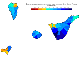
Population growth in recent decades is mainly centered on the island of Tenerife, especially on the south coast and the metropolitan area of Santa Cruz-La Laguna, while the north coast of Tenerife has lost population in recent years. The rest of the islands can be said to be suffering from population stagnation, with very slight growth or losses.
| Municipality | Population (2018) | Surface (km2) | Density(hab/km2) |
|---|---|---|---|
| Adeje | 47869 | 105.95 | 446.25 |
| Agulo | 1067 | 25,39 | 42,02 |
| Alajeró | 2006 | 49,42 | 40,59 |
| Arafo | 5562 | 34,27 | 162.30 |
| Arico | 7831 | 178,76 | 43,81 |
| Arona | 79448 | 81.79 | 971.37 |
| Barlovento | 1855 | 43,55 | 42,59 |
| Breña Alta | 7154 | 30.82 | 232,12 |
| Breña Baja | 5498 | 14,2 | 387.18 |
| Buenavista del Norte | 4755 | 67.45 | 70.50 |
| Candelaria | 27641 | 49.18 | 562.04 |
| Fasnia | 2768 | 45.11 | 61,36 |
| Border | 4018 | 80.12 | 50.15 |
| Fuencaliente de la Palma | 1709 | 56.42 | 30,29 |
| Garachico | 4819 | 29,28 | 164,58 |
| Garafía | 1626 | 103 | 15,79 |
| Granadilla de Abona | 48374 | 162.45 | 297,78 |
| Guancha, La | 5428 | 23,78 | 228,26 |
| Isora Guide | 20991 | 143.43 | 146.35 |
| Güímar | 19739 | 102.39 | 192,78 |
| Hermigua | 1805 | 39.67 | 45,50 |
| Icod de los Vinos | 22749 | 95.91 | 237,19 |
| San Cristobal de La Laguna | 155549 | 102.06 | 1524,09 |
| Llanos de Aridane, Los | 20171 | 35,79 | 563,59 |
| Matanza de Acentejo, La | 8956 | 14,11 | 634.73 |
| Orotava, La | 41833 | 207,31 | 201.79 |
| Step, El | 7543 | 135.92 | 55.50 |
| Port of the Cross | 30483 | 8,73 | 3491.75 |
| Puntagorda | 2073 | 31.1 | 66.66 |
| Puntallana | 2493 | 35.1 | 71.03 |
| Realejos, Los | 36405 | 57.09 | 637.68 |
| Rosario, El | 17352 | 39,43 | 440,07 |
| San Andrés y Sauces | 4112 | 42,75 | 96.19 |
| San Juan de la Rambla | 4799 | 20.67 | 232,17 |
| San Miguel de Abona | 19672 | 42,04 | 467,94 |
| San Sebastian de la Gomera | 8945 | 113.59 | 78.75 |
| Santa Cruz de la Palma | 15674 | 43,38 | 361,32 |
| Santa Cruz de Tenerife | 204856 | 150.56 | 1360.63 |
| Holy Ursula | 14445 | 22,59 | 639.44 |
| Santiago del Teide | 10755 | 52,21 | 206,00 |
| Sauzal, El | 8947 | 18,31 | 488,64 |
| Silos, the | 4757 | 24,23 | 196,33 |
| Tacoronte | 23961 | 30.09 | 796.31 |
| Tank, El | 2670 | 23,65 | 112.90 |
| Tazacorte | 4600 | 11,37 | 404,57 |
| Tegueste | 11203 | 26,41 | 424.20 |
| Tijarafe | 2564 | 53,76 | 47,69 |
| Valverde | 4955 | 103.65 | 47,81 |
| Great King | 4484 | 32,36 | 138.57 |
| Vallehermoso | 2829 | 109,32 | 25,88 |
| Victoria de Acentejo, La | 9040 | 18,36 | 492,37 |
| Vilaflor de Chasna | 1645 | 56.26 | 29,24 |
| Villa de Mazo | 4791 | 71.17 | 67.32 |
| Pinar de El Hierro, El | 1825 | 84.95 | 21,48 |
The province of Santa Cruz de Tenerife is the 43rd in Spain in which there is a higher percentage of inhabitants concentrated in its capital (20.11%, compared to 31.96% for the whole of Spain).

Population by municipality in the province of Santa Cruz de Tenerife

Population density by municipality
Population growth by municipality between 1998 and 2008

Population growth by municipality between 2008 and 2018


Contenido relacionado
Fee
Roncesvalles
Morocco