Province of Puntarenas
Puntarenas is province number 6 of Costa Rica, located in its western zone and covering most of the country's Pacific coast. It borders the provinces of Guanacaste, Alajuela, San José, Limón and Panama. It has an area of 11,265 km², which makes it the largest province in Costa Rica. It is divided into 13 cantons and 60 districts.
According to the 2011 census carried out by the National Institute of Statistics and Census (INEC), the total population of the province of Puntarenas was 410,929 inhabitants. 54.7% of the population is considered urban population. The province has a literacy rate of 96.2%, an average schooling of 7.2 years, and a 5.9% population born abroad. Its capital is the city of Puntarenas, which is located on a spit of land several kilometers long and about 400 m wide, flanked by an estuary on one side, and the Pacific Ocean on the other. Other important towns are Caldera - the country's main commercial port on the Pacific, Jacó, Parrita, Quepos, Puerto Cortés and Golfito.
The territory of the province of Puntarenas extends from the southeastern end of the Nicoya peninsula to the northwest, to Punta Burica, on the border with Panama, and encompasses several islands in the Pacific Ocean, such as the archipelago of the Gulf of Nicoya., and Cocos Island, located 550 km southwest of the Osa peninsula. The province has a varied relief, including high mountains, valleys, beaches and coastal landscapes. Puntarenas has a rugged coastline, which gives rise to numerous beaches and bays that make the province attractive for tourism. Its climate is dry tropical, with two well-defined seasons. It has numerous areas and protected zones of great biological wealth, such as Cabo Blanco, Manuel Antonio, Monte Verde and Corcovado. The province's economy includes commerce, the service sector, tourism, agricultural activities, mining, fishing and port activity.
The region of the province of Puntarenas was inhabited since pre-Columbian times, by Chorotega indigenous people of Mesoamerican culture, in the northwest, and by indigenous societies of Intermediate Area culture, mainly in the South Pacific. These towns bequeathed important cultural contributions to the country, highlighting the stone spheres, symbols of Costa Rica. Currently, there are numerous indigenous reserves in the southeast of the country that preserve a large part of their traditions, mainly in the cantons of Coto Brus and Buenos Aires de Puntarenas. The city of Puntarenas, known as 'The Pearl of the Pacific', was the country's main port for much of its history, became a National Spa in 1940, and today continues to be a main point of reference of the Costa Rican Pacific coast. The presence of numerous cultural traditions throughout its history, both of native peoples and immigrants, makes the culture of the province of Puntarenas one of the richest, most varied and recognizable in Costa Rica.
History

Pre-Columbian era
The current territory of the province of Puntarenas was inhabited in pre-Columbian times by various Amerindian groups, both of Mesoamerican influence and those of the Intermediate Area, who practically occupied the entire coast from the Gulf of Nicoya to Punta Burica. Among these groups, the Huetares of the West, the Chorotegas, the Quepoa, the Bruncas, the Coctú nation, and the Buricas are distinguished. These autochthonous groups were organized hierarchically into chiefdoms, had a subsistence agriculture based on corn, tubers, curcubitaceae and fishing, and had the presence of specialists who made ceramics of various types for both ritual and utilitarian purposes, as well as the manufacture of luxury objects of jade, gold, stone and other materials, which were used as signs of rank. The stone spheres stood out mainly, a unique artistic and cultural manifestation of the Costa Rican aborigines of the southeastern area of the province of Puntarenas.
Spanish conquest and colonization
The Pacific coast of Costa Rica was explored by the Spanish first by Juan Ponce de León, and then, in 1522, by Gil González Dávila, who traveled along the entire Puntarena coast, from the Golfo Dulce to the Gulf of Nicoya, and entered national territory through the mouth of the Tempisque River, to Nicoya and then Nicaragua. In 1524, Francisco Hernández de Córdoba established the first Spanish population in Costa Rica near the current Esparza, the town of Brussels, which subsisted until 1527. In 1529, Juan de Cavallón y Arboleda arrived in Chomes on the road to Nicaragua and Nicoya, and established the Real de la Ceniza, a Spanish garrison, between the mouths of the Machuca and Jesús María rivers, and from there he directed the explorations that, through the Grande de Tárcoles river, penetrated the Central Valley. In 1556, the second church in Costa Rican territory was built in Chomes. In 1563, the advance Juan Vázquez de Coronado followed Cavallón's route to the city of Castillo de Garcimuñoz, founded by him, and later, in alliance with local indigenous kings, he led an expedition to the southeast, where he came into contact with the Quepoa. and later, with the bruncas and coctús.
The town of Aranjuez, founded in 1568 by Perafán de Ribera, was the main Spanish port on the Pacific during the colonial period. The Spanish had partial control of the Costa Rican Pacific territory, well established in the northern and central Pacific area of the country, but their dominance was not total beyond Quepos], where the local indigenous people managed to retain a certain autonomy, although decimated by diseases. and miscegenation. In 1720 the name of the place appeared for the first time as “Punta de Arena”. It was the Panamanian Miguel Antonio de Unanué who was the first to use the Puntarenas spit of land as an embarkation port. Puntarenas was declared the country's largest port in 1814 by the Cortes of Cádiz at the request of Governor Tomás de Acosta y Hurtado de Mendoza.
From region to province and boom as a port

In 1834 an attempt was made to move the port to Caldera, but six years later it returned to Puntarenas as a state port and then as a free port (1847). In 1848, due to the small population, the region was given the rank of Comarca, and three years later, the canton of Puntarenas was created. Between 1840 and 1850, numerous infrastructure works were built to strengthen the port, which became the country's main port for the export of coffee to Europe, which became the main engine of the country's development. In 1855 the first migrations of Chinese began. For its participation in the National Campaign of 1856-1857, President Juan Rafael Mora Porras gave Puntarenas city status on September 17, 1858. In 1871, construction of the railroad began to connect Puntarenas with San José, which was It ended in 1910. This promoted national tourism, by improving the communication of the Central Valley with the Pacific. In 1909, Costa Rica restructured its political organization, dividing the country into seven provinces, thus creating the Province of Puntarenas.
Puntarenas in the 20th and 21st centuries
In 1915, a decree by Alfredo González Flores added the districts of Cóbano, Lepanto and Paquera, located on the Nicoya peninsula, to the canton of Puntarenas, increasing the surface area of the province, which became the largest in the country.. Between 1930 and 1940, various infrastructure was built in the city of Puntarenas, such as the main dock and the Captaincy. In 1936, the United Fruit Company began the cultivation of bananas in the Golfito region, an economic activity that lasted until 1984. After the Civil War of 1948, there was a new restructuring of the country's political organization, with the creation of new cantons., like Aguirre in 1948 and Parrita in 1971. Between 1950 and 1970, fishing activity increased in the Gulf of Nicoya. In 1970, the port of Caldera was inaugurated, which became the main port in the Costa Rican Pacific. To reactivate the province's economy, the Golfito Free Commercial Deposit was created in 1990 and the Barranca Free Trade Zone in 1992, but the fishing crisis worsened with the ban on trawling in 2013. At the end of the century XX and the beginning of the XXI century span>, numerous architectural projects were carried out with the purpose of improving tourist visitation to the city of Puntarenas, which began receiving cruise ships in the year 2000.
Geography
Relief
The province of Puntarenas is characterized by its long and rugged coastal relief. Its geography is irregular, with swampy areas (Corcovado), islands (Chira, Venado, Negritos, San Lucas, Herradura, Bejuco, Caballo, Cedros, Cuchillos, Violín), mangroves and peninsulas (Nicoya, Osa and Burica). Of its thirteen cantons, only five do not have Pacific coasts: Buenos Aires, Coto Brus and Corredores, located in the southeast region of the province, in the valley of the Grande de Térraba River, and the cantons of Montes de Oro and Monteverde, located north of the central canton of Puntarenas.
The mountain systems reach a maximum of 1834 m above sea level. n. m. in the area of the canton of Monteverde. The Costera or Brunqueña row, a branch of the Talamanca mountain range, runs parallel to the coast and encloses the valleys of Coto Brus and El General, to the southeast of the province. This row is crossed by the Grande de Térraba River, the longest in the country, and divides it into a southern section, with the Zapote (1,440 m a.s.l.) and Anguciana (1,707 m a.s.l.) hills, and another northern section, where the hills stand out. Palmar Norte (1,070 m a.s.l.) and Uvita (1,223 m a.s.l.).
Other minor mountain systems in the province are made up of the southern slope of the Tilarán mountain range, some hills of the Nicoya peninsula and the first foothills of the Talamanca mountain range. On the Osa peninsula, the Rincón (745 m a.s.l.), Brujo (617 m a.s.l.), Chocuaco (647 m a.s.l.) and Salsipuestas hills stand out. On the Nicoya peninsula, the Azul hills (1,018 m a.s.l.) and Frío hills (755 m a.s.l.) stand out.
The Puntarenas coastline has a northwest-southeast direction and includes three large geographic units:
- The Gulf of Nicoya and the end of the Nicoya Peninsula, where are Paquera, Lepanto and Cobano, districts of the central canton of Puntarenas. The Gulf is characterized by a sinuous coastal perimeter, with cliffs and mangrove areas. On the eastern coast of the Gulf, a land language stands out, where the city of Puntarenas is located. To the southeast of Puntarenas, is the port of Caldera, the most important of the Costa Rican Pacific.
- A flat and more rectilinear sector with numerous beaches, ranging from Herradura Bay to Coronado Bay. In this long coastline there are many populations, including Jaco, Parrita, Quepos, Dominical and Uvita.
- The Osa Peninsula with the Sweet Gulf and the western half of Burica tip. Here is the city of Golfito, important free commercial deposit.
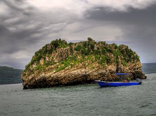
The Gulf of Nicoya contains an archipelago of islands located around the Nicoya peninsula, among which the island of Chira and the island of San Lucas stand out. Other important islands in the province are Herradura Island, located in the bay of the same name, and Caño Island, located in Coronado Bay. The latter stands out because in the past it was used as a ceremonial site and cemetery by the aboriginal cultures that inhabited this sector of the province. Cocos Island, located in the Pacific Ocean and with rich biodiversity, is an important national park and was declared a World Heritage Site by UNESCO.
- Islands of the province of Puntarenas
Caño Island, important pre-Columbian ceremonial site.
Coco Island, World Heritage, has a unique biological diversity in the world.
The Venado Islands (left) and Bejuco (right) views from Mount La Gloria, Nicoya Peninsula.
Tolinga Island, an islet close to Turtle Island.
Hydrography

The river courses of the province of Puntarenas originate in the neighboring provinces. They are characterized by the fact that their flow decreases during the dry season, with the exception of the Grande de Térraba River, whose basin is the largest and largest in the country (5,085 km²). The Térraba collects water from numerous tributaries from the Talamanca Mountain Range and the General and Coto Brus valleys, and pours them into Coronado Bay through a river delta.
The rest of the rivers are generally short and few. The Parrita, Savegre and Naranjo rivers stand out in the central area of the province. The Grande de Tárcoles River, which drains the waters of the Western Central Valley, empties into the entrance to the Gulf of Nicoya. Other important rivers are the Barranca River and the Jesús María River, which flow near the city of Puntarenas. Between the towns of Puntarenas and Punta Morales, the Aranjuez, Guacimal and Lagarto rivers flow, which come from the Tilarán mountain range.
There are also the Ario, General, Coto Brus and Coto rivers.
Protected areas

In the province of Puntarenas there are six conservation areas that include seven national parks (two of which are World Heritage Sites), three biological reserves and two wildlife refuges, assigned to the National System of Conservation Areas of Costa Rica:
Tempisque Conservation Area
The Tempisque Conservation Area (ACT) includes the entire Nicoya peninsula, whose southern tip, the districts of Lepanto, Cóbano and Paquera, belong to Puntarenas. In this area is the oldest protected area in Costa Rica, the Cabo Blanco Absolute Natural Reserve. The conservation area also includes several refuges located on the coastal strip of the peninsula, some of them private or semi-private, as well as wildlife refuges located on the islands of the Gulf of Nicoya.
| Wild areas of the Early Conservation Area in Puntarenas |
|---|
|
Arenal-Tempisque Conservation Area

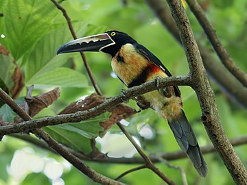
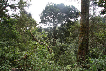
This area has territory in three provinces of the country (Guanacaste, Alajuela and Puntarenas). The part that corresponds to Puntarenas is located to the northwest, and includes the important Monteverde Cloud Forest Biological Reserve, located in the canton of Puntarenas, at the foot of the Sierra de Tilarán, and which receives around 70,000 tourists a year. In Monteverde alone, 70 of the 103 tree families reported for the country and 21.23% of the orchid species are represented. The reserve covers a biological conservation area that is located in the foothills of the Tilarán Mountain Range. It is the habitat of more than 2,000 species of plants and trees, 100 species of mammals, more than 400 species of birds and around 1,200 species of amphibians and reptiles. Among the species are the bellbird, jaguars, pumas, monkeys and toads. It is the habitat of more than 300 species of orchids and 200 species of ferns.
Central Pacific Conservation Area
The Central Pacific Conservation Area covers the lands between the community of Manzanillo, in the extreme north of the province of Puntarenas, to the Barú River in the canton of Quepos and the intermediate lands in the southwest of the Central Valley and part of the high mountain lands in the Talamanca Mountain Range, representing 11% of the national territory. It has 16 hydrographic basins, 11 of the 12 life zones, 7 of the 9 transitions and presents the 6 altitudinal levels into which the country is divided. It presents 5,640 plant species of the almost 90,000 thousand collected for the country, a figure that represents 62.7% of the plant species in Costa Rica. It reports at least 5000 species of plants endemic to Costa Rica, 201 of the 238 species of mammals existing in Costa Rica, including the 4 species of primates reported in Mesoamerica, as well as the 6 species of wild cats in America, 746 species of birds of the 892 established for Costa Rica. Three of the national parks in this area are located in the province of Puntarenas, including the Manuel Antonio National Park, one of the most attractive tourist centers in the country. The wildlife refuges located on Hermosa Beach and San Lucas Island are also part of this area.
| Wild areas of the Central Pacific Conservation Area in Puntarenas |
|---|
|
Coco Island Maritime Conservation Area

Declared a World Heritage Site according to UNESCO, Cocos Island is one of the most biodiverse sites in the world, where 235 species of plants (70 endemic), 362 of insects (64 endemic) and 2 of endemic reptiles; 3 of spiders, 100 of birds (13 residents, 3 endemic and in danger of extinction), 57 of crustaceans, 118 marine mollusks, more than 250 of fish, 600 of marine mollusks, 18 of corals 50 arthropods (7 are endemic), and 250 species of marine fish. Whitetip sharks, hammerhead sharks, yellowfin tuna, parrotfish, manta rays and horse mackerel proliferate in its waters. The French explorer and researcher Jacques-Yves Cousteau considered Cocos Island the most beautiful in the world during his lifetime.
La Amistad-Pacific Conservation Area
The La Amistad-Pacific Conservation Area includes La Amistad International Park and Chirripó National Park. Both parks have territory on the Pacific slope of the Talamanca mountain range, and include part of the territories of the Puntarenas cantons of Buenos Aires and Coto Brus. This area also has several indigenous territories: Térraba, of the Térraba ethnic group; Salitre and Cabagra, from the Bribri ethnic group; Abrojos Montezuma, Altos de San Antonio, Conte Burica, Coto Brus, Osa, from the Ngöbe ethnic group; and Boruca and Curré, of the Boruca ethnic group. The Las Tablas protective zone is also located in Coto Brus.
| Wild areas of the Conservation Area The Friendship-Pacific in Puntarenas |
|---|
|
Osa Conservation Area
It is located in the southern Pacific of the country and includes the Osa peninsula and the Golfo Dulce. Its biodiversity is very rich in terrestrial and marine species, endemic or in danger of extinction. The Corcovado National Park stands out mainly. Caño Island preserves vestiges of the country's pre-Columbian past. In the region there are several indigenous reserves of the Ngöbe ethnic group.
| Wild areas of the Osa Conservation Area |
|---|
|
Climate
In general, the province is characterized by having a dry tropical climate in the north of the province and humid in the south, with maximum temperatures around 34 °C, and minimum temperatures that rarely fall below 20 °C. The historical temperature marks are 17 °C and 42.3 °C, the latter also representing the highest temperature recorded in Costa Rica. In mountainous parts like Monteverde they can be around 12°C to 20°C, and in the mountain range area in the south of the province they can drop to 0°C. In the north of the province, the rainfall regime is around 1500-2500 mm annually, with the Cóbano area being the wettest with up to 3000 mm, while in the south of the province they can reach up to 5000 mm.
Administrative division
The province of Puntarenas was officially created as Comarca de Puntarenas by Law No. 36 of December 7, 1848. It acquired the title of province by legislative decree No. > 10 of September 17, 1858. Law No. 4666, "Law on the Administrative Territorial Division", of August 19, 1969, officially established Puntarenas as the sixth province of Costa Rica.
The province of Puntarenas is divided into 13 cantons and 60 districts. The cantons (In order of foundation) and their respective heads are:
| Canton | Head | Districts |
| Puntarenas | Puntarenas | Puntarenas, Pitahaya, Chomes, Lepanto, Paquera, Manzanillo, Guacimal, Barranca, Isla del Coco, Coconino, Chacarita, Chira, Acapulco, El Roble, Arancibia |
| Spread | Spread (Holy Spirit) | Holy Spirit, San Juan Grande, Macacona, San Rafael, San Jerónimo, Caldera |
| Buenos Aires | Buenos Aires | Buenos Aires, Volcano, Potrero Grande, Boruca, Pilas, Colinas, Chánguena, Biolley, Brunka |
| Montes de Oro | Miramar | Miramar, La Unión, San Isidro |
| Osa | Puerto Cortés | Puerto Cortés, Palmar, Sierpe, Piedras Blancas, Bahía Ballena, Bahía Drake |
| Quepos | Quepos | Quepos, Savegre, Naranjito |
| Golfito | Golfito | Golfito, Guaycará, Pavón, Comte-Burica |
| Coto Brus | San Vito | San Vito, Sabalito, Aguabuena, Limoncito, Pittier, Gutiérrez Braun |
| Parrita | Parrita | Parrita |
| Corridors | Neily City | Corridor, La Cuesta, Canoas, Laurel |
| Garabito | Jaco | Jaco, Tacoles, Lagunillas |
| Monteverde | Saint Helena | Monteverde |
| Puerto Jiménez | Puerto Jiménez | Puerto Jiménez |
Economy
The main economic activities in the province of Puntarenas are fishing and tourism, closely followed by agriculture and livestock. There is also important industrial activity.

In terms of foreign trade, Caldera, located 28 km south of the city of Puntarenas, in the canton of Esparza, is the main commercial seaport for imports and exports of the country located in the Pacific Ocean. 13% of the country's total exports leave this port, and 28% of the agricultural production that Costa Rica exports, especially sugar, alcohol, wood and fresh products such as pineapple, melon and cassava, containers, solid bulk., iron, vehicles, general merchandise and tuna, destined for the United States (45% of the country, of which 62% leaves through Caldera), China, Singapore, Argentina, Chile and Peru.
Agriculture
The agricultural activity of the province of Puntarenas is mainly characterized by the cultivation of African palm, which occupies 14,000 hectares of cultivated land. African palm is particularly abundant in the cantons of Parrita and Quepos, with the Palmatica company as the main producer. In cantons such as Garabito, Esparza, Parrita and Aguirre, the production of rice (12,496 ha), tobacco, corn, beans, fruits and vegetables is also important. Sugar cane is grown mainly in Esparza and Miramar.

Coffee is particularly important in the El General and Coto Brus valleys. Starting in the 1950s, coffee, which for many years was the driving force of the country's economy, began to develop in areas such as Coto Brus. It is worth highlighting that the communities located in the southeast of the province of Puntarenas have a close relationship with the Joséfino canton of Pérez Zeledón, which is the largest national producer of coffee, oriented towards export.
Bananas, the country's main agricultural product, were an important crop in the province of Puntarenas during the 1950s, and constituted a large enclave that spanned from Palmar Sur and Palmar Norte to Golfito. After the disappearance in the region of the main producing company, the transnational United Fruit Company, the large banana plantations came to be replaced by African palm plantations.
In recent years, a change has been observed in agricultural dynamics, with the introduction of non-traditional crops, mainly melon, but also papaya, watermelon and spices such as pepper and vanilla. Cabuya is also grown in the area of San Cristóbal, La Lucha and Frailes. Starting in the 1980s, the introduction of pineapple cultivation for export in the plains of Buenos Aires became the main non-traditional agricultural product. Its cultivation ranges from sowing to the packaging and freezing process. Currently, Costa Rica is the main pineapple exporting country in the world.
Livestock

Livestock farming is one of the most prominent economic activities in the region. It is extensive, based mainly on beef and dual-purpose cattle, and Indian blood species such as Brahmin predominate. In the area of Monteverde, in Montes de Oro, and in the central canton of Puntarenas, livestock farming for milk production is developed. The Monteverde cooperative stands out in this aspect, which produces cheese, butter, custard and other derivatives, destined for export and national consumption.
Livestock exploitation is very important in the southeastern cantons of the province, especially in the extensive valleys of General and Coto Brus. It relies on cattle for meat, milk and dual purpose. In this region, meat is marketed by cooperatives such as Coopemontecillos and also by intermediaries such as municipal slaughterhouses, butcher shops or livestock auctions.
Fishing

There are two main fishing centers in the province of Puntarenas: the city of Puntarenas itself, in the northwest of the province, and Quepos, located towards the southeast. The port of Puntarenas absorbs about 90% of the regional fishing fleet, while the second port absorbs about 9.9%. 96.5% of the fleet corresponds to artisanal vessels, pangas and boats, and 3.5% is dedicated to semi-industrial and industrial fishing. Fishing activity provides the country with nearly 3,500,000 kg of fish. Most of the catches are made in the Gulf of Nicoya (73.8%), and tuna and shrimp stand out. 25.9% of the catches at the national level are carried out in the Pacific area, which highlights the importance of Puntarenas as an entry of foreign currency to the country.
Towards the southeast of the province, fishing continues to be an important resource for its inhabitants. The area of greatest importance for this activity corresponds to the coastal area that extends between Punta Llorona and Punta Burica, including the Golfo Dulce. The main fish for commercialization are dorado and shark, as well as different types of mollusks.
Industry
As Puntarenas is one of the main fishing ports on the Pacific coast of Costa Rica, most of the processing centers dedicated to fish conservation have been installed there, with companies such as Sardimar and Tesoro del Mar.
Obtaining salt is another important industrial activity. There are also shipyards where fishing boats are built. Other relevant industries in the province are coffee processing, African palm (Palmatica), rice (Arrocera Miramar), wood, especially teak for export (Panamerican Woods), in Jicaral, dairy products (Monteverde, Coopemontecillos), processing of chemical products such as fertilizers (Fertica), in the canton of Puntarenas, and the transformation of metallurgy (aluminum) by the company Alunasa, in the canton of Esparza. In Barranca there is a free zone where maquila and clothing manufacturing is carried out. There are also light industries such as mechanical and electrical workshops, furniture and construction materials factories.
Tourism
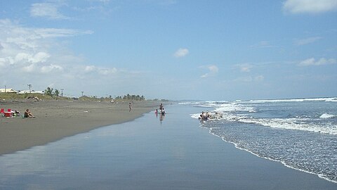
The Central Pacific is one of the main destinations for national and foreign tourism. Its natural and scenic wealth, the existence of numerous conservation areas, and its relative proximity to the Central Valley make it one of the main tourist attraction poles in Costa Rica. Tourism, the country's main economic activity and foreign exchange earnings, has increased the weight of some Puntarenas populations that have gone from small fishing towns to true urban centers, such as Jacó, Herradura, Parrita, Quepos, Golfito and Puerto Cortés.. In the last decade there has been considerable infrastructure development that can be seen in places such as Jacó or Playa Dominical, whose beaches are areas suitable for surfing that have attracted a significant flow of foreigners. In the surroundings of Jacó, in the last decade, there has been significant real estate development. The southern end of the Nicoya peninsula, where the districts of Lepanto, Paquera and Cóbano are located, is one of the most important tourist enclaves in the Costa Rican Pacific, where there are beaches such as Montezuma, Tambor, Pochote, Tortuga and Cabo Blanco.
City of Puntarenas
The city of Puntarenas, capital of the province, is rich in tradition, history and customs. It has various places of tourist interest, among which can be mentioned, in addition to the extensive beach, the Paseo de los Turistas, the Barrio El Carmen Spa, the cathedral boulevard, the marine park and the House of Culture. One of the tourist sites par excellence is the Paseo de los Turistas, a pedestrian avenue that borders the ocean, and where all kinds of businesses are located: hotels, bars, ice cream parlors, nightclubs, etc. In its numerous restaurants you can taste the typical dishes of Puntarenas gastronomy, such as vigorón, Puntarenas ceviche, chuchecas, resbaladera, arroz guacho, rice with seafood, stuffed grapefruits and granita, popularly known as "Churchill". ».

The rise of the city of Puntarenas as a tourist destination dates back to 1940, when it was baptized as "National Spa" due to the numerous visits by tourists from all over the territory, which were made mainly through the railway, which arrived directly to the heart of the beach, in the place that today is known as the Paseo de los Turistas. The train trip, which runs through different and picturesque communities from the valley to the port, currently only reaches Caldera, but even so, it continues to be attractive mainly among the Costa Rican population. Currently, land communication with the Pacific is carried out by paved roads such as the highway through the Aguacate mountains or the Inter-American Highway, but since the construction of Route 27 that connects the Central Valley with Caldera de Esparza, Travel time to the city of Puntarenas and its neighbors has been greatly shortened, which has further encouraged national and foreign tourism.
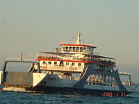
Puntarenas also functions as a stopover site to access other tourist regions of the country, such as the South Pacific or the province of Guanacaste. The city also has a ferry service that connects Puntarenas with the Nicoya peninsula. One of the most notable aspects of tourism in the city of Puntarenas in recent times is the arrival of international cruise ships at its dock. As of January 15, 2014, the inauguration of the Mesoamerican Route by the Azamara Quest cruise line allows passengers to board at the port of Caldera to make voyages between Costa Rica and the rest of Central America, Mexico and Los Angeles. in United States.
National parks and nature reserves
The province of Puntarenas has a great natural attraction that makes the region a receiving pole for foreign and national tourists. There are numerous landscapes made up of extensive beaches, some mountainous areas covered in cloud forest, valleys, hydrographic basins and rich fauna. In this regard, the notable tourist offer around the Manuel Antonio national park stands out, the second most visited in the country after the Poás Volcano national park, as well as the Monte Verde Cloud Forest Biological Reserve, which receives more than 70,000 national and foreign tourists. annually.
In the southeast region of the province, there is a free commercial warehouse in the city of Golfito that, together with the recent creation of the Piedras Blancas national park, encourages the visit of nationals to that region.
The Corcovado National Park, which preserves 41,788 hectares of shallow lagoons, mangroves, rivers, humid and cloud forests, and a large number of endangered animal species, attracts a large number of tourists, scientists and researchers every year. Around the park, which is accessed by a ferry between Golfito and Puerto Jiménez, on the eastern coast of the Osa peninsula, there are some hotels that also have private reservations.
Beaches
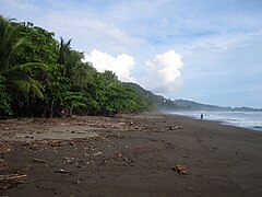
The beaches in the region mostly have hotels, hostels and cabins. According to the ranking «Travellers' Choice 2013", from the Tripadvisor website, two beaches in the province are among the 10 best in Central America: Manuel Antonio beach, selected as the best beach in Central America according to travelers, and Hermosa beach, ranked number 8. In 2016, Manuel Antonio beach was chosen by this same site as one of the best 25 beaches in the world.
Puntarenas
Beautiful
Bejuco
Uvita
Punta Leone
Manuel Antonio
Playa Espadilla
Dominical beach
Montezuma
Tortuga
Country
Playa Esterillos
Tambor
Corporal
Bodies
Jaco
Mining
Mining exploitation occurs in the southern area, where gold, zinc, iron and silver are extracted.
Infrastructure
Puntarenas is the largest province in Costa Rica and is connected to the rest of the country by land. It has a ferry that crosses the Gulf of Nicoya.
The most important ports in the province are Puntarenas, Caldera, Quepos and Golfito.
Multiple regional airfields are located in the province.
Culture
Art
Art is also an important exponent for the city, it currently has more than 25 stone sculptures resulting from national and international symposiums and are located along the "Paseo de los Turistas" and on the cathedral boulevard outdoors to be enjoyed by the public. Painters of national and international quality, Guillermo Trejos Cob, Isidro Con Wong and Jorge Rodríguez Iogui (National Scenography Award 2008 and currently president of the Association of Puntarenas Artists), adorn the province.
There is an association of Puntarenas artists that brings together different disciplines such as: theater, dance and folk dance, painting, sculpture, music; that seeks to project local artists on a national and international level.
In addition, theater becomes a very strong form of expression for Puntarenas where two National Theater Awards (2008) reside: Pablo Sibaja, category of Best Supporting Actor and Jorge Rodríguez Iogui in the category of Best Set Design. The public is constantly delighted with performances by Buenos Aires actors and actresses as guests and foreigners.
Pre-Columbian heritage
In the southeastern region of Puntarenas there are several indigenous reserves of the peoples who occupied the Térraba valley (called Diquís in the Boruca language) and the Osa peninsula during pre-Columbian times. These aboriginal peoples preserve their values, customs and traditions, although threatened by poverty and the acculturation process. Among these customs, the Game of the Little Devils of Boruca stands out, whose existence dates back to the times of the Spanish conquest. There are numerous archaeological remains in the region, such as those located in Palmar Sur de Osa, where a large number of stone spheres can still be found in their original site, which are currently considered a symbol of national identity. The vast majority of gold objects from the pre-Columbian era that are exhibited in the museums of San José also come from this important archaeological region, since the Osa region contains deposits of alluvial gold that pre-Columbian cultures used to create pendants, bracelets, discs and other objects. The Boruca Indigenous Community Museum, created in 1985 as an initiative of a group of women, is responsible for safeguarding the artistic heritage of this aboriginal people.
Illustrious people
- See Roster of Puntanians
Contenido relacionado
Tristan de Acuna
Portal:Mexico/Main article
New Town Cemetery
Portal:Chile/Featured/Votes
Matera


