
Province of La Rioja (Argentina)
La Rioja, in the text of the provincial Constitution: Province of La Rioja, is one of the twenty-three provinces or federated states of the Argentine Republic. It is one of the twenty-four self-governing states or first-order jurisdictions that make up the country, and one of the twenty-four national legislative electoral districts. Its capital and most populous city is the homonymous La Rioja. It is located in the northwest of the country, bordering Catamarca to the north, Córdoba to the east, San Luis to the south, San Juan to the southwest, and Chile to the northwest, whose border is determined by the watershed of the Cordillera de los Andes. With 387,728 inhabitants in 2016, it is the fourth least populated province —ahead of La Pampa, Santa Cruz and Tierra del Fuego, Antártida and Islas del Atlántico Sur, the least populated— and with 3.7 inhabitants/km², the sixth least densely populated, ahead of Catamarca, Río Negro, Chubut, La Pampa and Santa Cruz, the latter being the least densely populated.
In La Rioja, a mountainous relief with sparse vegetation predominates without the presence of a permanent water course. Its economy is supported by agriculture under artificial irrigation, with the production of vines and olive trees mainly, however, tourism has also grown considerably in recent years, with the Talampaya National Park standing out as the main attraction.
History
The Diaguitas inhabited the La Rioja territory when the Spanish conquerors arrived.
Since the creation of the Viceroyalty of Peru by royal decree of March 1, 1543, the current territory of La Rioja was integrated into the Governorate of Tucumán.
On May 20, 1591, Juan Ramírez de Velasco, from the Spanish region of La Rioja, founded "the City of All Saints of Nueva Rioja" with the aim of establishing a strategic seat to combat the indigenous.
In 1630 there was an uprising of the Diaguitas Indians that was put down by Governor Felipe de Albornoz.
The most notable demographic phenomenon of this era was the vertiginous increase in the population of African origin. Both in La Rioja and in the rest of Tucumán, the parcels had become extinct and the "Indians" they stopped paying tribute to the king, working for the Spaniards in parcels, so they tried to replace it with the blacks who entered, legally or illegally, through the port of Buenos Aires. It is amazing how many "blacks" registered in the censuses that the parish priests periodically carried out, such as the almost 500 slaves owned by the Society of Jesus, which had two ranches in the district.
In 1776 Tucumán became part of the newly created Viceroyalty of Río de la Plata.
When the Viceroyalty of Río de la Plata was administratively subdivided, in accordance with the Royal Ordinance of Intendants of January 28, 1782, the current province of La Rioja was located within the Intendancy of San Miguel de Tucumán governorate. The Royal Decree of August 5, 1783, abolished the governorship of Tucumán, with which the governorship of Córdoba del Tucumán was formed, which included Córdoba, San Luis, Mendoza, San Juan, La Rioja and small western sectors of the current province of Santa Fe.
A census of this area ordered by Viceroy Rafael de Sobremonte gave as a result that there were 9,887 inhabitants.
The local council supported the May Revolution and the Primera Junta.
In 1813, the Intendance of Cuyo was created and General José de San Martín assumed the position of governor, separating from Cordoba control, Mendoza, San Juan and San Luis, leaving La Rioja under the dependence of Córdoba.
In 1814, the Cordovan governor José Javier Díaz integrated the province of Córdoba into the «Union of Free Peoples» of José Gervasio Artigas as a federated province. La Rioja, which was part of the Municipality of Córdoba del Tucumán, ignored this action by the governor and temporarily remained autonomous. On December 15, 1817, the supporters of the unitary Directory of Buenos Aires returned to the government of Córdoba, returning La Rioja to the situation of government tenure.
After the uprising of the army in Arequito, a part of the rebels under the command of Francisco Villafañe, deposed Lieutenant Governor González on January 24, 1820 and elected, by acclamation, General Francisco Ortiz de Ocampo, former chief, governor de Arribeños in Buenos Aires and head of the first liberating expedition to Upper Peru.
A period of anarchy ensued until Facundo Quiroga, commander of Los Llanos (lower areas of southern Rioja), managed to impose himself with his rural militias and stabilize Nicolás Dávila in government in September 1821.
La Rioja was one of the thirteen signatory provinces of the Argentine Constitution of 1853 by which the Argentine Republic was established.
On February 3, 1881, an interprovincial treaty was signed with the province of San Luis, defining the boundaries between the two provinces.
The boundary with the Province of San Luis was established by National Law No. 22184, issued by the military government and published in the Official Gazette on March 12, 1980.
Since December 2019, the governor has been the Peronist, Ricardo Quintela.
Government
The province of La Rioja is an autonomous state, which integrates the Argentine Republic according to the rules of the federal regime established by the Constitution in force since 1853, retaining all powers not expressly delegated to the national State.
For this reason, the province is governed by three independent powers: the Executive Power headed by a governor, the unicameral Legislative Power, and the Judiciary Power headed by the Superior Court.
..jpg)
Culture
Religious festivals
San Nicolás de Bari, the patron saint of the province, is celebrated in the city of La Rioja in July.
On December 31, the Tinkunaco Festival is celebrated. Encounter between the Child Jesus Alcalde and San Nicolás de Bari. It takes place at noon in front of the Government House. This party is also lived in the Department of Famatina and in Malligasta (Department of Chilecito).
The San Francisco Solano Pilgrimage to Las Padercitas (Quebrada de los Sauces) takes place on the second Sunday of August. The faithful of all the neighborhood congregations of the capital city make their walk in the morning and return in the afternoon. Feast of the Indian Virgin (Sanagasta) every last Friday of September. He comes on a pilgrimage to La Rioja. Every September 24, in the city of La Rioja, the Virgin of Mercedes, general of the army, is honored. On Fridays of Holy Week, the traditional pilgrimages to the Lord of Peña are carried out, in the Department of Arauco. In Chilecito the feast of Santa Rita is officiated with deep fervor, on May 22.
In February, the festival of San Blas, in San Blas de los Sauces and that of Our Lady of Candelaria, in Olta. In June those of San Pedro and San Pablo in Famatina and that of San Antonio de Padua in Anillaco. In August, the festival of Santa Rosa de Lima, in Patquia. In October, the celebration of our Lady of the Rosary, in Ulapes, Chamical, Tama and Villa Unión. In December, the Immaculate Conception, in Aimogasta and Chepes, and that of Our Lady of Andacoyo in Vinchina.

Popular Beliefs
As it happens in the other provinces of Argentina and especially in rural areas, there are popular legends and myths in La Rioja. In the valleys, in the ravines, in the mountains, in the sunny plains, in the posts and places, in the abandoned mines, local traditions of indigenous and Creole origin persist.
Among the mythological characters that are supposed to live in the Famatina and Velasco ravines, the following can be mentioned: Pachamama or Mother of the Earth; the Llastay or Owner of the animals and birds of the hill; the Huayrapuca or Colorado Wind, which whips the valleys and mountainous slopes of western Rioja; the Mikilo, a small and mischievous man; the Kuntur, demon kidnapper of children who live in the hills; the Yacumama or Yacurmana, which appears in the water currents that come down from the mountain in cascades, and can be seen from afar in all directions; the Zapan Zucum, protector of children and the carob tree; the Pujllay or god of Chaya, represented as a ragged doll mounted on a donkey, who evokes sadness and joy through his singing, and wanders throughout the town. It is said that at the end of each Chaya, he buries it until the next, when he revives. Other mythical characters from La Rioja are: the Mulanima, an animal with chains that appears at night; the sombrero leprechaun, a short man who appears during naps; the black hand, the witches and Salamanca, the secret place where they hold their meetings.
Traditional foods

Like all the provinces of Argentina, La Rioja has its own culinary tradition. Among the typical foods, the following stand out:
Humita en chala is a grated corn paste mixed with chili and other seasonings, wrapped in corn husks. The api squash is a mixture of squash, cheese, onion and chili that the people of La Rioja eat, especially at Easter.
During the different popular festivals in the province, locro is a must, a stew made with meat, corn, beans, pumpkin, and chili, and empanadas, made with minced meat, potatoes, olives, raisins, chili, and others. seasonings, wrapped in dough.
In the Llanos region of La Rioja, roast kid is a deep-rooted custom. In addition, the kid entrails are minced to make the chanfaina. Other traditional foods include stewed busecas, mazamorra, Creole roast, machaco, sandunga, chicharrón, quesillo or goat cheese, and charqui.
Among the Riojan drinks, the aloja or añapa stand out, which is made with ground and fermented carob that is consumed especially at Christmas. Among the sweets is the arrope, the apricots, the patay and the zambumba.
Provincial Anthem of La Rioja
Oíd las riojanos the cry of Chacho,
resounding on the infernal plain,
igniting in the monkey's blood
the volcanoes of freedom.
See shreds of ponchos and spears,
in hard entrevero under the quebrachal,
and Quiroga's voice, thunder,
silenced for being federal.
Do not forget that it has remained on the hill,
the prayer of this Diaguita town,
than listening to Solano's violin
His blessed word learned.
Carry with the strength of the Zonda and the sun,
through fertile valleys, through burning plains,
by chayeros hills of eternal snow,
Your noble spirit, your indigenous blood. (Bis)
Lyrics: Leila Mirta Marasco de Bilmezis Music: Francisco Frega
Festivals
Rituals are characteristic in each and every corner of La Rioja. In them, each town evokes in its songs the culture, experiences and activities that identify it.
The most relevant is the Chaya Festival, which takes place in February in the capital of the province. And that brings together the whole town for four nights.
During Christmas in the Hills, in Chilecito, Christmas carols are sung.
In the Viñador festival, in the town of Villa Unión, the town highlights this activity, and sings to their land, to the vine and to the wine.
In Milagro, an entire region gathers at the Beef Festival, to pay homage to its traditional grenadier activity.
According to the place where they live, the people of La Rioja are inspired by the countryside, the river, the mountain and all those that are part of their landscape to honor their land and evoke their sorrow and joy. In this way, they revive their festivities according to their predominant activities, such as Quesillo, in Las Peñas (Castro Barros Department); the Friendship Festival in Anillaco; del Cabrito in Chepes; of the Peach in Guandacol; Dressage in Pinchas; of the Walnut in Famatina, etc.
La Chaya
It is a traditional festival in the province of La Rioja that takes place in February of each year and where an ancestral custom is revived. It is then when the festival is held and the classic clash in the neighborhoods of the city, in which the participants. This custom has been carried out approximately since 1942.
Tourism


The natural beauties of the province form an attractive invitation to tourism. Some of the main centers are found in Chilecito, at the foot of the majestic Famatina massif; in Nonogasta, in the valley of the Río Grande or de los Sauces, and in Villa Unión, from where you can access the Talampaya National Park which, due to its scenic and paleontological value, has been declared a World Heritage Site by Unesco, together with Ischigualasto in the neighboring province of San Juan. In the plains, Olta, Malanzán and the General Ocampo Department (Balneario de Aguadita de Los Peralta and Ambil) stand out.
In the capital city, La Rioja, you can visit the Artisan Route, the Religious Circuit in the historic center, the Inca Huasi Archaeological Museum and the Castro Barros Cultural Walk. On the outskirts is the City Park, as a space for multiple uses, and the ruins of Las Padercitas, which allow you to learn about the first inhabitants of La Rioja.
The province has the Dique de los Sauces, a traditional place for water sports and silverside fishing, as well as the Sanagasta dam, which is characterized by a special microclimate, its artisan markets and museums, the possibility of practicing activities such as hiking, horseback riding and rappelling, and visiting places such as the Cueva de las Brujas, the Sanagasta and Huaco Geological Park, all accompanied by a captivating landscape.
In the department of Castro Barros there is a succession of small towns that are located at more than 1,000 m a.s.l. no. m. where peace reigns and which have a special micro climate, these towns are enclosed by the eastern and western slopes of Velasco, which are called the Costa Riojana
In the Department of Arauco in Señor de la Peña every Thursday and Good Friday, pilgrims and promises arrive in search of spiritual peace, invoking their protection, from different parts of the region and the country.
The Vientos del Señor tourist complex is an extensive surface of clay soil, where you can practice sand yachting, Kitebuggy and recreational activities such as horseback riding, bicycle tours, walks, enjoying the scenery.
Termas de Santa Teresita, located in a mountainous area, provides water that reaches between 42° and 46°, producing hydrotherapeutic effects.
Passing through Aimogasta is the Archaeological Site of Huaco, located in the department of San Blas de los Sauces. On the other hand, Chilecito has a photographic safari along the La Mejicana Mine cableway, and rural tourism activities between farms and wineries. In the town of Miranda, is the Cuesta de Miranda and the river that bears the same name: There is a set of historic chapels, all of them declared a national historic monument. In Famatina you can practice paragliding and get to know the Ocre ravine. The towns of Ángulos and Campanas gather thousands of parishioners every year for the Niño de Hualco festival. In Chañarmuyo there is a dam for recreational activities. In Patquía there is the Chiflón Provincial Park, where guided tours are carried out among petroglyphs and community mortars of the aboriginal essence, and the Los Colorados Provincial Reserve, where hiking is practiced.
In the department of General Ángel Vicente Peñaloza there are several historical, cultural and natural attractions, such as the Chila lagoons, standing out the Quebrada de los Cóndores. This is a plateau that has panoramic views of Olta and its dam, adding to the fact that more than 150 condors inhabit it, which makes it the most important condor reserve outside the Andes. In Olta there is the dam of the same name and there is the famous Caminito in which Gabino Peñaloza was inspired.
The city of Villa Unión is the most important center of the Bermejo Valley (which integrates the El Chiflon Provincial Park, the Talampaya National Park and the Laguna Brava Nature Reserve) and is the starting point to continue learning about the history of El Condado, Quebrada del Yeso and Cerro el Toro.
In Vinchina you can see the Estrellas Diaguitas, the Quebrada de la Troya and discover fossilized footprints and petrified forests.
Place name
The etymology of the place name Rioja, named after the autonomous community of La Rioja (Spain) and inherited by the province of La Rioja and its capital in Argentina, has been much discussed. The main theories are: The one that makes it correspond with the Oja river; the one that points out as a seed a nominal tautology in the term rivo Ohia that would mean "river of fluvial bed", the one that points to the term "rivalia" which would be translated as land of streams; and the multiple ones that indicate that it would have its origins in the Basque language, for example as a union of the words erria and eguia, which would be translated as land of bread. This name appears written for the first time in a document from the Middle Ages dated in the year 1099, the Fuero de Miranda de Ebro.
Geography


It is located in the northwest of the country. The west of the province is within the Andean region and most of it within the geographical region called Sierras Pampeanas. In the northern part of the province, it is crossed by several mountain ranges such as the Sierra de Velasco and the Sierra de Famatina, whose summit is the high Cerro General Belgrano (which, with an altitude of 6250 m.a.s.l., is the extra-Andean summit highest in the world outside of Asia), which run from north to south and form wide valleys between them. The south has several mountains isolated by plains. Its territory occupies an area of 89,680 km², so its extension can be compared with that of Portugal.
It basically presents three areas that go from the south to the north:
- The south has a low relief, dominated by the Sierra de los Llanos and other adjacent mountains, such as the Mines and Malanzán mountains, surrounded by all semi-desert plains. Something far from the main mountains, heading south, is the Sierra de Chepes. The area also has the largest dam in the province, the dam of Anzulon. Among these mountains are villages such as Chamical, Chepes, Olta, Malanzán and Ulapes.
- The southeast of the province is the lowest area and there is the penillanura called Los Llanos de La Rioja and at the limits the desert depression of the Salinas Grandes.
 Climate rates of La Rioja according to Köppen
- The southeast of the province is the lowest area and there is the penillanura called Los Llanos de La Rioja and at the limits the desert depression of the Salinas Grandes.
.svg)
- The centre of the province has two major formations, the Sierra de Velasco and the Sierra de Famatina. On the east side of the Sierra de Velasco the capital of the province is located.
The Sierra de Velasco bifurcates in two, forming a valley that is known as "La Costa" or "La Costa de Arauco", where there are relatively important towns, such as Aimogasta, Anillaco and Aminga. At its northwest end, the mountain range gives way to a narrow valley, occupied by a series of small towns, the most important of which is Salicas.
To the east of the Sierra de Velasco is a wide semi-desert plain, almost uninhabited, barely interrupted by the Sierra Brava. Most of the rivers in the province flow into this wide plain, losing themselves in flood and saline drains.
- To the west of the Sierra de Velasco is a wide valley, the Valley of Famatina or Antinaco, whose center occupies the city of Chilecito. Around the year 2000, the valley has seen its agricultural production very increased, with the contribution of irrigation with groundwater. In this valley are also the villages of Famatina, Campanas, Pituil, Nonogasta, Vichigasta, Anguinán, Sañogasta and Los Sarmientos.
- In the Sierra de Famatina you will find the General Belgrano hill, with a height of 6250 m n. m., at the foot of which is the city of Chilecito.
The Sierra de Famatina also adjoins other mountains known as Sierra de Paganzo and Sierra de Sañogasta, to the southwest of which is the Talampaya National Park. The Sierra de Sañogasta in its northern term begins the Sierra de Famatina; between them they form a strait that is known as the Cuesta de Miranda.
- The western sector of the province is formed, from east to west, by:
- the wide valley of the Vinchina River, occupied by populations such as Guandacol, Villa Unión and Villa San José de Vinchina.
- the precordillera, which includes some saws such as Umango and Del Toro Muerto;
- a plateau, partially occupied by the Laguna Brava Provincial Reserve; and
- the Andes, which marks the limit with Chile. In this area you will find the highest summits of the province, such as Cerro Bonete, of 6.759 m. n. m., Cerro Veladero, of 6.471 m. n. m., and Monte Pissis, which are among the highest peaks of Argentina. The only sporadicly empowered step to access Chile from La Rioja is the international step Pircas Negras: La Rioja is the only Argentine province bordering Chile that still lacks (2012) a permanent international step towards that country.
Seismicity
The seismicity of the La Rioja region is frequent and of low intensity, and a seismic silence of medium to severe earthquakes every 30 years in random areas. Its last expressions occurred:
- 12 April 1899 (123 years), at 16.10 UTC-3 with 6.4 Richter; as in every seismic town, even with a short seismic silence, the history of other regional seismic movements (La Rioja Earthquake of 1899) is forgotten.
- October 24, 1957 (65 years old), at 22.07 UTC-3 with 6.0 Richter (Villa Castelli Earthquake of 1957): In addition to the physical gravity of the phenomenon, the oblivion of the population joined these recurring events
- 28 May 2002 (20 years), at 0.03 UTC-3, with 6.0 Richter scale (La Rioja Earthquake 2002)
In this regard, the large number of buildings with concrete roofs, buildings with baked brick walls stands out; without adherence to anti-seismic building regulations.
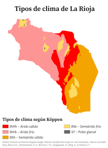
Climate and vegetation


The climate in most of the territory is continental semi-arid and mountain arid, with low humidity, due to the fact that the humid winds come from the South Atlantic anticyclone and when they reach this province they do so with low humidity and strong solar radiation (heliophany). In the lowlands, summers are very hot and winters are short, with moderate temperatures. Rainfall does not exceed 400 mm per year, with the exception of some mountainous areas, where it is somewhat more important.

The dominant natural vegetation is xerophytic, scrubby shrubs, with few tree formations, where different species of carob trees (Prosopis sp.), aguaribay and Ziziphus mistol grow..

La Rioja presents characteristics typical of a continental climate. Winters are mild and dry, with average temperatures above 10 °C and little rain, as well as a high daily oscillation. Summers are rainy and extremely hot with average maximum temperatures of 35.3 °C [and average minimum of 25 °C], and absolute maximums around 48 °C, one of the highest in Argentina. During the period between December 2012 and February 2013, the province recorded the highest average daily temperature (average between maximum and minimum daily record) in Argentina, rising to 30.27 °C.[ citation required] Regarding the aforementioned period (90 days), 14 days registered maximum temperatures equal to or greater than 40 °C, and 5 days registered minimum temperatures equal to or greater than 30 °C (it can be done note that, frequently, the daily maximum temperature is recorded between 5:00 p.m. and 7:00 p.m.; and the daily minimum temperature between 4:00 a.m. and 6:00 a.m.). It is also common to find periods of two or three consecutive days with maximum daily temperatures in the range of 38 to 40 degrees Celsius, with a strong component of atmospheric humidity (50% to 60%). As statistical data for the period indicated above, it will be noted that the absolute maximum temperature was recorded on December 24, 2012, reaching 44 °C in the shade.
Water resources


Due to the prevailing semi-arid climate, almost all agricultural activity in the province of La Rioja depends on the contribution of its few and meager rivers, along which all its towns rise.
The rivers of the province provide highly variable flows, and most of them, with the exception of the Vinchina River, form part of a large endorheic basin, which also includes most of the province of Catamarca, part of the north and northwest of the province of San Luis, the extreme east of the province of San Juan, and the extreme west and northwest of the province of Córdoba. Among the most outstanding we find the Sanagasta river, the Abaucán or Arauco river, and other minor currents.
Other basins present in La Rioja are the plains and the Antinaco-Los Colorados valley, the former belonging to the southern territory of the province, formed by small rivers of short length and low flow (which only a few few are permanent). These are used in dams built for drinking or irrigation water, such as Olta, Anzulon and Portezuelo. Several slopes are also born that are used for human consumption.
The Los Colorados-Antinaco valley basin is divided into several sub-basins, which are:
- From the Miranda River: one of the most flowing sub-basins has. It runs through the Miranda Cuesta.
- From the river Durazno: it is the most used basin for human consumption and irrigation. After the water is captured, it follows its course with the name of the river Los Sarmientos, currently dry, leading to the Lower River of Saint Helena.
- From the Guanchín River: this basin is very unused since it has a variable volume. When the town of Sañogasta passes, it receives the name of Rio Grande and flows into the Lower River of Santa Helena in the form of napa.
- From the Capayán River: it is the most untapped river in the entire basin. It sinks as a form of nap and flows into the Lower River of Saint Helena.
- From the Angle River: it is a transient river, which has only water in times of exceptional rains.
- From the White River: it is a river of permanent flow and is taken advantage of by the dam Chañarmuyo.
- From the river Campanas: it is a river with permanent water that flows into the dam of Chañarmuyo.
All these rivers flow into the main river called Bajo de Santa Helena, which is a permanent river in exceptional times and goes to the groundwater. The Vinchina River is formed with the contribution of the Jagüé River, which is born on the slopes of Monte Pissis and Cerro Bonete, and other minor streams that come down from the Sierra de Famatina. By joining the La Troya or Guandacol river, on the border with San Juan, both form the Bermejo river. After several name changes, of which the most used is that of the Desaguadero River, it is lost in the western region of the province of La Pampa; Previously it flowed into the Colorado River, which currently does not provide any flow, except in years of exceptional flooding.
La Rioja Capital is located in the lower valley of the Rio Grande de La Rioja, which is currently completely dry. This river, called the Sanagasta River in its upper course, is dammed by the Los Sauces Dam upstream of the city; it provides drinking water to the city, which recursively (10 to 12 events a year, in spring or summer) is subjected to partial and focused cuts in the drinking water service. The water that is not used for human consumption is used for irrigation.
Economy
The provincial economy is based primarily on agriculture. This is located on irrigated surfaces and its products are mostly marketed in the country. The main crop is grapes. To a lesser extent, walnut, olive, jojoba, other fruits (for example almonds and dates) and various vegetables are cultivated.
They are dedicated to the manufacture of wines, the production of nuts/walnuts and olives, and leather.
They mainly raise cattle and goats.
Historically, mining has been and is important, especially the gold and copper mines (such as those of Famatina). Since 2008, educational centers have become an important pole of development of the local economy, in the growth of the demand for rentals and services by foreign students, and not natives of the province. Regarding the latter, the growth of students from the National University of La Rioja stands out.
Economic Regions
The economy of La Rioja is divided according to the regions that are located. These and their economic activities are the following:[citation required]
- Bermejo Region (I): this region is made up of the city of Villa Unión, the village Villa Castelli and Vinchina, all heads of the department General Felpe Varela, General Lamadrid and Vinchina respectively. The economy is based on fruit production. It is a corridor that connects La Rioja with Chile through the Pircas Negras Pass on route 76. This step became the tourist corridor par excellence as it has natural and historical attractions.
- Region of Valle Antinaco-Los Colorados (II): is the most productive region in the province. It is supplied with shallow and underground irrigation, and it produces vine, walnut olive and small vegetables. It is composed of the following cities: Chilecito, Nonogasta, Vichigasta, Sañogasta and Famatina
- Region North (III): its main pole is Aimogasta, as it produces olive and in good quantity. On the riojana coast it is produced for auto supply in general vegetables. The same is true in the department of San Blas, but it has several tourist attractions and therefore takes strength, without taking into account that it has a very enormous energy power by the wind farm Arauco. The cities and towns that make up the region are Aimogasta, Anillaco, Aminga and San Blas de los Sauces.
- Capital Region (IV): The industrial park that produces several goods is concentrated in this area. There is also agricultural production by groundwater. This region is the most populous, with the huge disparity that exists in terms of the number of inhabitants between the two existing localities, while the city of La Rioja has more than 150,000 inhabitants, Villa Sanagasta has only 2000, and acts as a satellite and the summer town of La Rioja.
- Northern plain region (V): it is a region that is dedicated to agriculture and is based on extensive livestock. It has several attractions such as El Chiflón Park, Talampaya, Quebrada de los Condores y Caminito. The cities and towns of this region are Chamical, Olta, Patchia, Tama and Punta de los Llanos.
- South plain region (VI): it is a region that only has irrigation in the town of Catuna and the rest is dedicated to the extensive breeding of goats. At the beginning of the 20th century it was populated by forests of brittles and carob trees, with the passage of time these were deforested. This region suffers from the massive exodus to San Juan or to the city of La Rioja. It has several tourist attractions such as the Quebrada de Ambil, the Guasamayo reserve, the Copacabana virgin and the Caudillos Route in San Antonio. The cities and towns of this region are Chepes, Ulapes, Malanzan, Santa Rita de Catuna, Milagro and Portezuelo.

Administrative division
The province is divided into 18 departments. The provincial Constitution was sanctioned in 1855, with modifications in 1866. A new constitution was sanctioned in 1986 and modified in 2011.
The province recognizes provincial autonomy and establishes that all municipalities must issue their organic charter.
Unlike most Argentine provinces, in La Rioja the departments and municipalities are the same entity, which are listed under Municipalities of La Rioja (Argentina). For information on the municipal organization of the province, see: Municipal Organization of La Rioja (Argentina).
,_departments_and_capital.png)
| Department | Home town |
|---|---|
| Arauco | Aimogasta |
| Capital | La Rioja |
| Castro Barros | Aminga |
| Chamical | Chamical |
| Chilecito | Chilecito |
| Colonel Felipe Varela | Villa Unión |
| Famatina | Famatina |
| General Angel V. Peñaloza | Tama |
| General Belgrano | Olta |
| General Juan Facundo Quiroga | Malanzán |
| General Lamadrid | Villa Castelli |
| General Ocampo | Miracle |
| General San Martín | Ulapes |
| Independence | Patchia |
| Rosario Vera Peñaloza | Chepes |
| San Blas de los Sauces | San Blas |
| Sanagasta | Villa Sanagasta |
| Vinchina | Villa San José de Vinchina |
Boundary dispute with San Juan
Decree-Law No. 18,004, promulgated by the military government on December 23, 1968, established the boundaries between the provinces of La Rioja and San Juan. Previously, the military controllers of both provinces entered into an agreement on March 12, 1968 in order to put an end to a secular boundary dispute. On December 21, 1973, the Legislature of La Rioja sanctioned Provincial Law No. 3468, ignoring the validity of the Decree-Law of the military government. The Government of San Juan enacted Provincial Law No. 3580 in January 1969, ratifying the interprovincial agreement signed by the military inspectors in 1968. The dispute centers on the glacier and the hill, both called El Potro, with potential copper and gold mining, where Decree-Law No. 18004 established that the limit starts from El Potro hill, heading from there in a southeasterly direction until reaching the Blanco river, but it does not say what the angle of the southeast direction is, so the area was delimited but not demarcated.
Demographics


Historical evolution of the population of the province:
- 1778: 9,699.
- 1783: 9,887 hectares.
- 1795: 14,231 hab.
- 1814: 14,095 hab.
- 1820: ca. 18,000-200,000 hectares.
- 1847: ca. 25,000.
- 1853: ca. 30,000 hectares.
- 1869: 48,746 hab.
- 1895: 69,502.
- 1914: 79,754 hab.
- 1947: 110,746 hab.
- 1960: 128,220 hab.
- 1970: 136,237 hab.
- 1980: 164,217 hab.
- 1991: 220,779 inhabitants (Indec, 1991) (urban population: 167,142 (Indec, 1991)), (rural population:53,587 (Indec, 1991).
- 2001: 289,820 inhabitants (Indec, 2001) (urban population: 241,289 (Indec, 2001), rural population:48,531 (Indec, 2001).
- 2010: 331,847 inhabitants (urban population: 288,518 (Indec, 2010), rural population:45,124 (Indec, 2010)
| Graphic of demographic evolution of La Rioja between 1869 and |
 |
Ethnic composition
During the great wave of European immigration, La Rioja was the province that received the fewest immigrants, both in quantitative and relative terms. Despite this, the province has been a recipient of immigrants from other parts of the world, mainly from the Arab world, with Syria and Lebanon standing out.
Main cities and towns
| N.o | City | Department | Population |
|---|---|---|---|
| 1 | La Rioja | Capital | 178.872 |
| 2 | Chilecito | Chilecito | 33.724 |
| 3 | Chamical | Chamical | 12.919 |
| 4 | Aimogasta | Arauco | 12.249 |
| 5 | Chepes | Rosario Vera Peñaloza | 11.039 |
| 6 | Nonogasta | Chilecito | 6.937 |
| 7 | Villa Unión | Felipe Varela | 4.639 |
| 8 | Olta | General Belgrano | 4.547 |
| 9 | San Blas de los Sauces | San Blas de los Sauces | 3.918 |
| 10 | Miracle | General Ocampo | 3.494 |
Sports

- Football: Racing Club, Club Atlético Independiente, El Club Atlético Defensores de la Boca el Club Américo Tesorieri.
- Basketball: Club Facundo, Club Atlético Riojano, Club Atlético Independiente, Club Amancay, Club Social y Deportivo San Martín.
- Rugby: Chelcos Rugby club, Social Rugby Club, C.R.A.R, Orange R.C, San Patricio R.C. of the Capital, Matacos Rugby Club de Chamical, Nevado Rugby Club and Takú R.C. of Chilecito, Montoneros R.C. de Olta and El Olivo R.C de Aimogasta.
- Swimming: Municipal Sports (competitive swimming, school, promotional and national federated) and Physical Education Center No. 5 (recreational swimming, older adults).
Featured Characters
Contenido relacionado
Rome
Coordinated Universal Time
4th century BC c.