
Popocatepetl
The Popocatépetl (Spanish) ![]() [popokaridetepetl] (?·i)Nahuatl
[popokaridetepetl] (?·i)Nahuatl ![]() [popo feltkaıtepe wrappedt ] (?·i)(of the Nahuatl: Popōcatepētl or Popokatepetl‘Cerro que humea’) is an active volcano located in Mexico. It is within the territorial limits of the states of Mexico, Morelos and Puebla. It is located about 72 km southeast of Mexico City, 43 km from Puebla, 63 km from Cuernavaca, and 53 km from Tlaxcala.
[popo feltkaıtepe wrappedt ] (?·i)(of the Nahuatl: Popōcatepētl or Popokatepetl‘Cerro que humea’) is an active volcano located in Mexico. It is within the territorial limits of the states of Mexico, Morelos and Puebla. It is located about 72 km southeast of Mexico City, 43 km from Puebla, 63 km from Cuernavaca, and 53 km from Tlaxcala.
It has a symmetrical conical shape, and is linked to Iztaccíhuatl on the north by a mountain pass known as Paso de Cortés. The volcano had perennial glaciers near the mouth of the cone, at the tip of the mountain. It is the second highest volcano in Mexico, with a maximum altitude of 5,400 meters above sea level, only after Citlaltépetl, at 5,636 m.
On June 3, 2019, it recorded two new explosions that led the Mexican government to declare a type 3 yellow alert, warning of a possible ash fall in the municipalities of Ecatzingo and Atlautla, in the State of Mexico; Ciudad Ayala, Cuautla, Jantetelco, Jonacatepec, Ocuituco, Temoac, Tetela del Volcán, Yecapixtla and Zacualpan, in the state of Morelos, and in Acteopan, Atzitzihuacán, Cohuecan and Tochimilco, in the state of Puebla.
Toponymy
Its name, from the Nahuatl language, composed of Popōca "to smoke" and tepētl "mountain, hill", together means "mountain that smokes", due to to its already constant activity since pre-Hispanic times.
Geology
Popocatépetl is a stratovolcano, and paleomagnetic studies of it indicate that it is approximately 730,000 years old. Its height is 5,500 m s. no. m., is conical in shape, has a diameter of 25 km at its base and the top is the elliptical cut of a cone and has a northeast-southwest orientation. The distance between the walls of its crater varies between 660 and 840 m.
Popocatépetl has always been active, despite having been at rest for a good part of the second half of the XX century. In 1991 an increase in its activity began and from 1993 the fumaroles were already clearly visible from distances of around 50 kilometers.
In addition, there are a large number of records from ancient times about the periods of activity of the volcano, and an eruption is even recorded in 1927, which was artificially caused by the dynamiting of the crater to extract sulfur from it. The last violent eruption of the volcano occurred from December 18 to 19, 2000. On December 25, 2005, a new explosion occurred in the crater of the volcano, which caused a column of smoke and ash 3 kilometers high and the expulsion of lava.
Given that lava can come out of any fissure that occurs on its slopes and not just from its crater, it is difficult to know in advance which areas would be affected in the event of an eruption. The most that can be said is that if the lava came out of the north or northeast, or east and southeast, the state of Puebla would be affected. If it came out of the south, the state of Mexico and possibly the state of Morelos would be affected., and if it left the west and southwest side, the region where the population of Amecameca is located would be affected. The surface area affected will depend on the viscosity of the lava. As a last theoretical possibility, if the crater were filled with lava (unlikely), it would spill out on the northeast side, the direction in which the lower edge of the crater is located.
The areas that would be affected by the ashes and gases from Popocatépetl would depend on the direction of the winds, mainly at the height of the crater. Broadly speaking, it can be said that if the emissions occurred from November to April, the Puebla valley would be affected. If the eruption occurred from June to September, the southern region of the state of Mexico and the state of Morelos would be the regions at greatest risk[citation required], although they could also suffer damaged the southern end of Mexico City[citation needed].
However, knowing all this is not enough to save lives, since even knowing that in a large eruption that occurred in January, for example, the winds would carry the cloud of ash and gases towards the state of Puebla[ citation needed], there probably would not be enough time to organize an evacuation, since it is currently not possible to predict well in advance when the phenomenon will occur. For this reason, measurements are being made of the deformations of the volcano and its hydrothermal activity, and records of the seismic activity that comes from the bowels of the volcano are being made, which allow efficient and adequate plans to be put in place to save the population from a disaster[citation needed].
On the other hand, the volume of ice contained in the Popocatépetl glaciers is greater than 17 million cubic meters. These glaciers are located on the northwest-north face and if they melted suddenly, the water current would probably be channeled through the central ravine and the Ventorrillo ravine[citation needed]. In this situation, Santiago Xalitzintla, San Nicolás de los Ranchos and San Pedro Benito Juárez could be some of the most affected towns. In the rainy season, it is expected that the mudflow affects a larger area because the soil has less capacity to absorb or infiltrate water because it is saturated by water. It could also cause acid rain in the event of a violent explosion.
History

Pre-Columbian times
Excavations carried out on the northeast slope of the volcano, in the Tetimpa housing complex, have revealed human occupation since 800 BC. C. It was discontinued by an eruption at the dawn of the Christian era (s. i) and another around 700-850 AD. C., covering the area with a layer of pumice whose thickness reached 2 m in height.
Conquest
The first recorded ascent of this volcano was made by the Spanish led by Diego de Ordás in 1519.
Hernán Cortés described it like this:
That eight leagues in this city of Churultecal are two very high and very wonderful mountain ranges, because in the end of August they have so much snow than anything else high of them if not snow, it seems. And from the one that is the highest one comes out many times, as well as day and night, as large pile of smoke as a great house and climbs up the mountain to the clouds, as right as a vita, which, it seems, is so much the force with which it comes out that although up in the mountain range it always laughed the wind, it cannot twist it. And because I have always wished of all the things of this earth to be able to make your highness very particular relationship, I wanted of this, that it seemed to me something wonderful, to know the secret and sent ten of my companions, such that for such a business they were necessary and with some natural of the land that guided them and entrusted them much to try to raise the said mountain and know the secret of that smoke, from where and how it came out. They went and worked what was possible to go up and they could never, because of the much snow that in the saw there are and many torbellinos that from the ash that comes out of there go through the saw and also because they could not suffer the great coldness that was upward, but they came very close to the high and so much that when they were up there they began to come out that smoke and say that it went out with so much momentum and noise that it looked down.
News
Popocatépetl has been one of the most active volcanoes in Mexico. Since 1354, 18 eruptions have been recorded. In 1927 a considerable eruption occurred, thus initiating a period of rest. Then, on December 21, 1994, after several years of inactivity, the volcano registered an explosion that produced gas and ash that were transported by the prevailing winds more than 25 km away. Currently its activity is moderate, but constant, with the emission of fumaroles, composed of gases and water vapor, and sudden and unforeseen minor expulsions of ash and volcanic material. The last violent eruption of the volcano was recorded in December 2000, which, following the predictions of scientists, led to the evacuation of thousands of people in the areas near the volcano. On December 25, 2005, a new explosion occurred in the crater of the volcano, which caused a column of smoke and ash three kilometers high and the expulsion of lava. Later on the morning of June 3, 2011, Popocatépetl again emitted large fumaroles without causing damage. On November 20, 2011, a great explosion took place that made the earth tremble, being heard in the towns near the slopes, but without major disturbance. On the morning of January 16, 2012, the volcano registered a fumarole of water vapor and ash, without this representing risks for the population surrounding the colossus.
On April 16, 2012, CENAPRED (National Center for Disaster Prevention) raised the volcanic alert traffic light from yellow phase 2 to yellow phase 3 due to the great activity that has been taking place, without until the moment represents a serious danger to society.
At 3:23 a.m. on April 30, 2013, the Popocatépetl volcano spewed incandescent fragments 800 meters from the crater on the northeastern slope, reported the National Center for Disaster Prevention (CENAPRED).
On May 12, 2013, after the loud noise that was felt in the town of Atlixco, the National Coordination of Civil Protection of the Ministry of the Interior, reported a change in the traffic light of the volcanic alert, from yellow phase 2 to phase 3 due to the increase in the activity of the Volcano, for which the Popocatépetl Operational Plan came into action. Through a statement, SEGOB announced that in a meeting with the Scientific Advisory Committee, at the National Center for the Prevention of Disasters (CENAPRED) that, due to the fact that explosions, vulcano-tectonic events, tremor episodes and exhalation trains were observed in the previous two weeks, the Committee concluded by consensus to issue the recommendation. However, on June 2, 2013, CENAPRED returned the alert level to yellow phase 2.
On June 17 and 18, the volcano registered several explosive events of greater magnitude, recording Fumaroles that reached 4 km above the crater level and expulsions of incandescent rock that reached the slopes on the South-West side of the colossus. The alert remained in yellow phase 2.
The volcano became active on July 7, 2013, spewing clearly visible ash in nearby towns, the ash also reached Mexico City, spewing pyroclastic flows and incandescence. The volcanic traffic light was placed in yellow phase 3.
The volcano registered an explosion on January 22, 2019, launching incandescent material and ash, this explosion could be felt in areas surrounding the volcano (areas of the state of Puebla and the State of Mexico) however the volcanic traffic light was located in yellow phase 2, on February 9 and 18 the volcano released strong fumaroles, the ashes reached Puebla and Tlaxcala, on February 14 the volcano released incandescent material and ash again, the volcanic traffic light continued in yellow phase 2, on February 22 On March 26, 2019, the volcano registered a strong explosion, again releasing incandescent material accompanied by ash, it even burned some grasslands near the volcano, the noise was heard in the areas surrounding the volcano, on March 26 and 27 the volcano again It registered explosions of incandescent material accompanied by lava, ash and toxic gases, it came to burn several pastures, which were on the slopes of the volcano, on the morning of March 28, 2019 it launched strong f umarols that reached 4 km above the level of the crater, that same day the traffic light was placed in yellow phase 3.
In 1994, the 16th century monasteries built on its slopes were declared a UNESCO World Heritage Site.
Precursors of eruptions
Volcanic eruptions can be preceded by changes in seismic and vulcanomagnetic activity, in the chemical composition of gases, spring water, and sometimes by deformation. To make an adequate volcanic forecast, it is necessary to recognize these indicative signs of an eruption and its timing. The eruptions of Popocatépetl that began on December 21, 1994, were preceded by increases in volcanotectonic (VT) seismic events, changes in temperature and concentration of sulfates and chlorides in the crater lake and in pCO2 in the springs. There was also a drop in pH in some springs several months before the eruption. Long-period seismic events also increased prior to some eruptions, and harmonic tremor episodes as well as negative magnetic anomalies preceded doming and are linked to magma rise. The cumulative seismic energy of volcanotectonic seismic events shows an acceleration in the rate before the main eruptions. There were clear precursors before the eruptions of December to January 2001, such as negative magnetic anomalies, correlated with the increase in seismicity, as well as small changes in the springs. These changes occurred two months before the eruption. Additionally, a few days before there were episodes of high-amplitude harmonic tremor and an increase in the flow of SO2, this, together with the analysis of the RSAM data, allowed an adequate evaluation and prognosis of the 2000 eruption.
Eruption of November 3 and 6, 2014
At 10:54 p.m. on November 4, a large column of smoke was already visible over the volcano, which ended at 1:35 in the morning. During this period of time, various explosions containing incandescent material, steam of water, small amounts of ash at 11:45; They declared that the volcano had entered an eruptive state, but that these small eruptions were foreseen at the phase 2 yellow volcanic alert level, so it was not necessary to modify the alert level. During this activity there were no injuries and no incidents since the ash and incandescent material fell only in the Cortés pass.
Eruption of April 18, 2016

In the early morning of April 18, 2016, at approximately 2:15 a.m. (local time) the volcano began to have activity. Ash emissions began first, followed by a series of small eruptions. Subsequently, around 3:00 a.m., there was a strong eruptive phase followed by a shower of incandescent material, which reached a radius of 1.6 kilometers. This generated a fumarole that extended several kilometers, which caused ash fall in nearby cities.
High volcanic activity
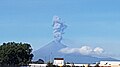
_2.JPG)
Popocatépetl is known for its high volcanic activity that occurs commonly. Since it was reactivated in 1994, up to now it has presented a series of eruptions of which the most violent have been that of the year 2000, and the early morning of April 18, 2016. Another eruption was that of February 16, 2018 after the 7.2 earthquake on the Richter scale that struck Mexico. The volcano ejected a large fumarole of water and ash that reached 700 meters in height at 6:24 p.m. local time.
The last recorded eruption was on April 11, 2020.
.jpg)
The volcano is one of the most monitored in the world and it is also one of the most dangerous, threatening more than 26 million people.
Visits
Popocatépetl is an active volcano, access to which is currently restricted to the general public, only professionals and civil protection personnel are allowed to climb, with prior identification and preparation of a permit; specifying objectives as well as certifying the personality and capacity of the applicant. Continuous monitoring of volcanic activity is maintained, in order to alert and provide protection to the inhabitants of neighboring towns.
For nature lovers, in the Iztaccíhuatl-Popocatépetl National Park you can do various activities such as mountain biking, extreme sports such as mountaineering on the Iztaccíhuatl volcano, or hiking, where it is possible to appreciate beautiful places and forests where they live white tailed deer, rabbits, skunks, squirrels. The best season to visit the place is from November to March.
Mythology
Legend has it that in pre-Hispanic times Itzaccíhuatl, a Tlaxcalan princess of great beauty, and Popocatépetl, a handsome and brave warrior, lived before leaving for the war in which the Tlaxcalans were immersed against their staunch enemies, the Aztecs. Popocatépetl asked the chief of his town for the hand of the princess Iztaccíhuatl. He granted it to her on the condition that he return safely from the war to marry her. Thus, the warrior went to battle while the princess awaited the return of her love. However, the tongue of a jealous rival of Popocatépetl mediated in bad faith, deceiving the princess and informing her that her lover had died in combat. Dragged by inconsolation and brokenness, victim of her deceit, she died of sadness for the loss of her beloved. A short time later, Popocatépetl returned victorious from the battle willing to marry Iztaccíhuatl; however, upon his arrival, he received the unfortunate news of his death. For several days and nights, they say that the young man wandered through the streets until he found a way to honor the great love that both professed, and that is how he ordered a great tomb to be erected under the sun, piling up 10 hills to raise a huge mountain. Once built, he took the inert body of the princess from her, and laying her down on the top of the mountain, kissed her one last time so that after her, with a smoking torch in hand, he would kneel to watch over her eternal dream of she. Since then, they have stayed together, facing each other. Over time, the snow covered their bodies, which became two huge volcanoes and would remain unchanged until the end of time.
Another legend related to this volcano is related to one of the affectionate nicknames that the population of nearby towns have given to the mountain. This volcano is also known as "Don Goyo", short for Gregorio, since it is said that, from time to time, an old man appears on his way to "somewhere" in the different towns in the area and calls himself Don Gregorio. or Chinese Gregory. The local people assure that this old man is the personification of the volcano that comes to make sure that the people who inhabit the area act in good faith and show respect to the volcano so that, if so, good fortune smiles on them.
Gallery
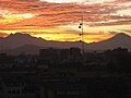
Iztaccíhuatl and Popocatépetl at dawn from Mexico City.

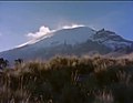
Fumarola del Popocatépetl (22 January 2001), heading south. The city of Puebla can be seen at the bottom left of the image and Mexico City on the right side.

The Popocatepetl Volcano seen from the town of Cuijingo (January 2010).

The Popocatepetl Volcano between 1890 and 1930.
The Popocatepetl Volcano during its resting period (year 1960).
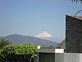
Photo of Popocatepetl from the municipality of Jiutepec, Morelos.

Popocatépetl seen from the north of Mexico City (January 2016).

View from Mexico City of Iztaccihuatl and Popocatépetl volcanoes.

View from Cortés Pass.
View from Iztaccíhuatl.
View from UNAM.
Popocatépetl Volcano Activity in 2019.

Satellite view of Popocatépetl.

Popocatépetl activity in December 2001.

Popocatépetl seen from space in February 2020

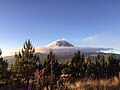
The Popocatépetl, seen from Amecameca, state of Mexico.


Contenido relacionado
Geology of the Falkland Islands
Alicante Province
Carob tree (Spain)