Pilcomayo River National Park


The Río Pilcomayo National Park is located 5 km from the town of Laguna Blanca and 4 km from the town of Laguna Naick Neck, in the province of Formosa in Argentina. It has an area of 51,889 ha and its geographical center is at the coordinates 25°04′00″S 58°07′00″W / -25.06667, -58.11667.
Creation
The Río Pilcomayo National Park was created by law no. 14073, sanctioned on September 29, 1951 and promulgated on October 17, 1951 by decree no. 20756/1951.
Créase the Rio Pilcomayo National Park in the national territory of Formosa, whose limits will be: to the Northwest the southern arm of the river Pilcomayo to its intersection with the north arm of the same river; to the northeast and east the river Pilcomayo to its mouth in the river Paraguay, and to the south to the mouth of the black river
The province of Formosa was created by law no. 14408 sanctioned on June 16, 1955 and promulgated by decree no. 9947/1955 of June 28, 1955, which provided:
ARTICLE 10. - The property located within their respective territorial limits that belong to the public or private domain of the Nation shall be transferred to the domain of the new provinces except those that need to be used for national public use or service, in which case the reservation shall be established by the National Act within three years of the promulgation of the present.
Decree Law No. 654/1958 of January 21, 1958 provided:
Art. 5o - In the terms of Article 10 of Law No. 14.408, the following national parks and natural monuments shall continue to belong to the domain of the National State: (...) (a) Pilcomayo National Park, in the province of Formosa, with the limits specified by Law No. 14.073;
Originally it had 285,000 hectares, but at the request of the Formosa Legislature on September 27, 1968, Law No. 17915 was sanctioned and promulgated, which reduced it to 51,889 hectares. The disaffected area was transferred to the provincial State.
Article 1.- Modify the limits of the Rio Pilcomayo National Park determined by Law 14.073 that are fixed in the following form: to the Northwest the southern arm of the Rio Pilcomayo from Puerto Ramos to its confluence with the north arm of the same river; to the northeast the River Pilcomayo to the meridian 57o 58to the east, this meridian; to the south, the parallel 25° 10from that meridian to the east margin of the Laguna Blanca, then surrounding it through its South and West margins; to Southwest, a line sensibly straight from the last point mentioned to Puerto Ramos, passing through the post El Quebrachal.
Article 3.- Transfer to the Province of Formosa the domain of the surface that, from the limits described above, is excluded from the jurisdiction of the Río Pilcomayo National Park.
Decree No. 2149/90 of October 10, 1990 designated a sector of the national park as a strict nature reserve. The limits of the strict nature reserve were modified by Decree No. 453/1994 of 23 March 1994, which reduced it and created the wild nature reserve.
In 2006, the Five-Year Management Plan 2007–2011 Río Pilcomayo National Park was approved.
Features
The area protects a representative area of the Eastern or Humid Chaco environments. Due to the varied types of climates and soils, there are different plant communities:
- Coastal jungle.
- Mountain Islets: forest formations in the form of islands.
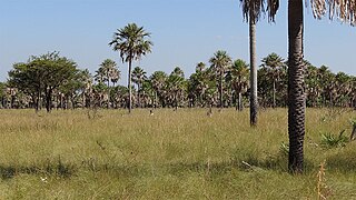
- Palm savannahs: with a discontinuous tree stratum and a herbaceous one.
It houses large species: quebracho, white and red, and showy lapachos. In the lower strata, smaller trees grow: carob trees, guayabí trees and palo drunkos.
This impenetrable mountain is inhabited by animals such as the guazuncho (corzuela), capybaras, peccaries, howler monkeys, pumas and birds such as the charata and the ipacahá. In the lower areas, the maned guazú, the rhea and the chuñas live, all of them have the particularity of having long limbs that allow them to move comfortably in the high grasslands and flooded areas.
Aquatic environments are inhabited by storks, herons, roseate spoonbills and ducks; also two species of alligators, the black and the overo. Fish from these waters have adaptations that allow them to survive in periods of drought, such as the tamboatá or cascarudo, being able to breathe atmospheric air and change puddles by propelling themselves with their pectoral fins.
This park has been included in the List of Wetlands of International Importance (Ramsar Convention).
It is an area with little slope, with many grasslands, estuaries and lagoons. The area is subject to periodic floods that alternate with periods of drought, creating vast and growing flooded areas in the summer. Subtle unevenness of the terrain allows us to differentiate sectors with different probabilities of flooding, one of the determining factors of the environmental diversity of the area. Most of the Park's surface is occupied by grasslands and caranday palm groves, with estuaries in the lowlands and mountain islets at the highest points.
- White palm or caranday: up to 14 m tall and glauco-green palm leaves; this arboreal porte monocotley is used by the cotorras and other birds to make their nests. The carpenter heads straw and the ñenday parrot nest in the holes of their trunks. These palm trees are also used as a shelter for bats as the large long long tail
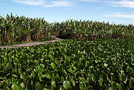
In Laguna Blanca, the largest body of water in the park with 700 hectares, two species of alligator live: the overo and the black, both in danger of extinction. There are also various snakes such as the curiyú boa and aquatic snakes, among which the ñacaniná stands out. On its coasts, extensive pehuajozales and pirizales develop where capybaras and coypus or "otters" live.
Climate
The park's climatic type is humid tropical with no dry season. Precipitation averages 1,200 mm annually, and the average annual temperature is 23 °C. In summer, maximum temperatures can reach 45°C and winters are not exempt from days with low temperatures, but these frosts only occur on some occasions.
The area is affected by the South Atlantic anticyclone and the thermal low of the South American continent, which promote the formation of tropical air masses. The combination of these masses with the polar Atlantic masses determines the rainfall regime.
As for rainfall, there is a marked decrease in the winter season and two peaks of increase, one in the month of March, which is more pronounced, and another mild one in the month of November.
It is important to note that the Park is located within the area of frequent tornado production, but there is no good record of them.
Administration
By resolution No. 126/2011 of the National Parks Administration of May 19, 2011, it was established that the national park would be classified for administrative purposes in the category protected areas of complexity II, for which is headed by an appointed intendant, to which 4 departments depend (Administration; Works and Maintenance; National Park Rangers; Conservation and Public Use) and 2 divisions (Office and Desk of Entries, Exits, and Notifications; Human Resources and Training). The mayor's office has its headquarters in the town of Laguna Blanca.
Amenities
Camping, bathrooms, information offices, first aid room, parking, places to bathe. Interpretation trails. Walks guided by a park ranger. Hotels in Clorinda and Laguna Blanca.
Access mode
RN 11 connects the cities of Formosa (capital of the Province) and Clorinda. RN 86 starts from Clorinda, passing near the southern limit of the Park, in the town of Laguna Naick Neck. From here, after traveling 4 km along a country road, you arrive at the recreational area and the Laguna Blanca Park Ranger Section.
You can also access the Park from the town of Laguna Blanca —located on National Route No. 86, 65 km from Clorinda— along a local road that after 7 km reaches the “Estero Poí” Park Ranger Section. The Park Administration is located in the town of Laguna Blanca. In the Laguna Blanca recreational area there is a camp with counters, toilets and stoves. From there, two interpretation trails start.
- Sendero to the Laguna Blanca: you can access by walkways, through a pajozal, where carpinchos and yacarés can be seen between achiras of yellow flowers and vines, as well as a variety of pale birds. In the water body you can perform navigation without motor.
Image gallery
Laguna Blanca
Gateways
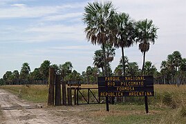
Entrance to the park
Rhea


