Petrus Plancius

Petrus Plancius (Dranouter, now Heuvelland, 1552 – May 15, 1622), Latinized form of Pieter Platevoet, was a Flemish theologian, cartographer and astronomer. He is known for having introduced the Mercator projection method to navigation maps and for developing a new method of measuring longitude. He published several guides and navigation diaries, his best-known work being a map of the world, the Nova et Exacta Terrarum Tabula geographica et hydrographica (1592).
Biography
He was born Pieter Platevoet in Dranouter, now in Heuvelland, West Flanders. He studied theology in Germany and England. At the age of 24 he was ordained a minister of the Dutch Reformed Church.
Due to fear of religious persecution by the Inquisition, he fled from Brussels to Amsterdam after the city fell to the Spanish in 1585. There he became interested in navigation and cartography and, being fortunate enough to have access to nautical charts recently brought from Portugal, he was soon recognized as an expert on the sea routes to India. He firmly believed in the existence of a northeast passage, until the failure of Willem Barents' third voyage in 1597 seemed to exclude the possibility of such a route.
Cartographer
He was one of the founders of the Dutch East India Company for which he made more than 100 maps and navigation charts. He became the company's official cartographer.
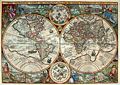
In 1592 he published his best-known map, the world map titled Nova et exacta Terrarum Tabula Geographica et hydrographica. Apart from maps, he published journals and navigation guides and developed a new method of determining longitude. He also introduced the Mercator projection to navigation maps.
Plancius was a friend of Henry Hudson, the English navigator still known today for his explorations in the New World and the search for a passage to the Pacific Ocean through the North Pole.
The new southern constellations
In 1589 Plancius had collaborated with the Amsterdam cartographer Jacob Floris van Langren on a 32.5 cm celestial globe, on which, using the limited information available on the celestial characteristics of the southern hemisphere, he represented for the first time: the Crux of the Southern Cross, the Triangulum Australe, in the southern triangle, and the Magellanic Clouds, the Large Magellanic Cloud and the Small Magellanic Cloud.
Therefore, on the occasion of the first Dutch expedition to the East Indies in 1595, Plancius asked the Dutch navigator Pieter Dirkszoon Keyser, chief pilot of the Hollandia, to carry out astronomical observations for the purpose to fill the hitherto empty spaces in the area of the south celestial pole. Keyser died during that expedition in Java - the expedition had many casualties - but his observations were delivered to Plancius by the later well-known explorer Frederick de Houtman. The observations referred to a catalog of 135 stars probably obtained with the help of the same Houtman, then his assistant. These stars were then organized into 12 new southern constellations, which were represented on a 35 cm celestial globe, which was prepared in late 1597 (or early 1598) in collaboration with the Amsterdam cartographer Jodocus Hondius the Elder.
Those constellations of Plancius (which made reference above all to animals and themes described in natural history books and travel diaries of his time) were the following: Apus, the bird of paradise; Chamaeleon, the chameleon; Dorado, the golden carp (or swordfish); Grus, the crane; Hydrus, the little water snake; Indus, representing the American Indian; Musca, the fly; Pavo, the peacock; Phoenix; Triangulum Australe, the southern triangle; Tucana, the toucan; and Volans, the flying fish.
These constellations, together with the constellation of Columba, introduced by Plancius in his great wall map of the world of 1592, were incorporated in 1603 by Johann Bayer in his atlas of the sky, Uranometria.
In 1612 (or 1613) Plancius presented the following eight constellations on a 26.5 cm celestial globe published in Amsterdam by Pieter van der Keere: Apes, the ox; Camelopardalis, the giraffe (many represented as a camel); Cancer Minor, the crab; Tigris, the Tigris River; Gallus the rooster; Jordanus, the Jordan River; Monoceros, the unicorn; and Sagitta Australis, the arrow of the South. Of the later constellations, only Camelopardalis and Monoceros are still found in modern sky charts.
Recognitions
The minor planet 10648 Plancius commemorates his contributions to celestial and terrestrial cartography.
Maps

Orbis Terrarum, 1590
Orbis Terrarum de Petrus Plancius, 1594

Nova France.. Terra Nova, 1592

Insulae Moluccae, 1592


