Pechora River
The Pechora River (also transliterated as Petchora) (Russian: ' Печора ' Pečora; in Komi, Печӧра; in Nenezo, Санэроˮ яха) is a river in northern European Russia that flows into the Pechora Sea (Barents Sea, Ocean Arctic). It is 1809 km long (making it the sixth longest in Europe) and drains a basin of 322,000 km². Administratively, it runs through the Komi Republic and the Nenets Autonomous District.
Name
The name of the river probably comes from the name of the Pechora tribe, recorded here by Russian annals. If the hydronym is primary, the name is old and possibly related to the hydronym, in Komi 'Visera'. - Vishera.
Ethnographer B. O. Dolgikh believed the name comes from the Nenezo peo language, or Nenezo language - "forest" and Idioma nenezo 'ter', or in Idioma nenezo 'der' - "inhabitant", which means "inhabitant of the forest".
The Mansi call the river Peserya, according to one version the hydronym means "pechora (tribe) river", in Mansi it means "river", i.e., could also be the basis of the river's modern name.
Geography
This river rises in the Northern Ural Mountains at Koyp in Russia. It has a length of 1809 km, basin - 322 thousand km². It rises in the Northern Urals, in the southeast of the Komi Republic, and flows mainly to the southwest. It is born at 675 m above sea level. In 1981, a cast iron slab with the inscription "From here the great northern river Pechora is born" It marked the beginning or source of the river.
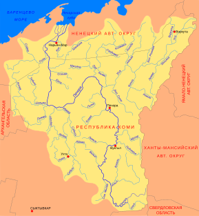
From its source to the mouth of the Unya, the Pechora has a mountainous character. At the village of Yakshi (after the confluence with the Volostnitsa River), it turns north and flows along the Pechora plain to Ust-Usa. After the mouth of the Usa it turns to the west, forming a broad elbow with two large curves. The width of the channel here reaches 2 km and extensive floodplains appear in the valley. In the Ust-Tsilma area (after the confluence of the Pizhma and Tsilma rivers) the Pechora turns north again, in this section its wide floodplain is cut by numerous channels ("spheres") and meander-shaped lakes.
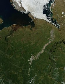
About 130 km from the mouth the Pechora splits into two branches, the eastern (Bolshaya Pechora) and the western (Malaya Pechora) branches. Downstream, near Naryan-Mar, the river forms a delta about 45 km wide and flows into the Pechora Bay of the Pechora Sea.
Runoff currents extend south to the town of Oxina.
The overall slope of the river is 0.373 m/km. In its upper reaches (upstream of Ilycha) the slope is 2.5-3.0 m/km, the river is fast and rapid, and its bottom is stony. Below Ust-Ilycha the slope is 0.10-0.11 m/km, the flow of the Pechora almost doubles, the channel widens from 100-150 to 300 m, the bottom changes from stony to sandy, mixed with pebbles and gravel.
Its main tributaries are the following rivers:
- on the right:
- river Ilytch (Illic), with a length of 411 km, a flow of 177 m3/s and a basin of 16 000 km2;
- Shchugor river (storage), with a length of 300 km, a flow of 252 m3/s and a basin of 9660 one km2;
- river Usá (рса), with a length of 565 km, a flow of 1310 m3/s and a basin of 93 600 km2;
- Ersai river (Ёрса), with a length of 206 km and a basin of 2520 km2;
- River Lai (Liada), with a length of 332 km and a basin of 9530 km2;
- Shapkina river (Shopstone), with a length of 499 km, a flow of 582 m3/s and a basin of 6570 km2;
- on the left:
- River Severnaïa Mylva (Северная Мылва), with a length of 213 km, a flow of 29.5 m3/s and a basin of 5970 km2;
- Kojva river (Коrugва), with a length of 194 km and a basin of 9560 km2;
- River Lija (LEDGE), with a length of 223 km and a basin of 6620 km2;
- river Izhma or Izva (Izhma), with a length of 531 km, a flow of 317 m3/s and a basin of 31 000 km2;
- River Tsilma (Consililla), with a length of 374 km, a flow of 228 m3/s and a basin of 21 500 km2;
- river Pizhma (Пиrugма), with a length of 389 km, a flow of 55 m3/s and a basin of 5470 km2;
- river Vel (Вель), with a length of 173 km and a basin of 4110 km2;
- River Lemjo, with a length of 197 km and a basin of 4310 km2;
- river Un'ja (рнья), with a length of 163 km, a flow of 45 m3/s a basin of 2890 km2;
- River Sula (Carlo), with a length of 353 km, a flow of 92 m3/s a basin of 10 400 km2;
Maps
On the second map you can read the names of three cities in its course: Vuktyl (Вукты́л), Pechora (Печора) and Narian-Mar (Нарьян-Мар). This river flows into the Arctic Ocean next to the Northern Dvina River, in spring the melting causes its flow to increase significantly.
Hydrology
The average monthly flow of the river was recorded between 1981 and 1993 in the town of Oksino, located 141 km upstream from the mouth. The values are presented in the diagram below (metric units, m3/s)..

Flow rates of the Petchora at different points of its course
| Locality | Distance from the mouth (km) | Recruitment area km2 | Module] (m3/s) | water level (mm) |
|---|---|---|---|---|
| Troïtsko-Petchorsk62°43′N 56°13′E / 62.72, 56.22 | 1359 | 35600 | 530 | 470 |
| Oust-Chougor64°16′N 57°37′E / 64.27, 57.62 | 1036 | 67500 | 1067 | 499 |
| Moutny Materik65°57′N 55°10′E / 65.95, 55.17 | 610 | 205000 | 3146 | 484 |
| Oust-Tsilma65°25′N 52°17′E / 65.42, 52.28 | 425 | 248000 | 3440 | 431 |
| Oksino67°38′N 52°11′E / 67.63, 52.18 | 141 | 312000 | 4379 | 485 |
Geology
The Pechora Basin is framed by two primary age ridges forming a V and connected by a glacial deposit threshold: to the west the Timan ridge (200-300 m) and to the east the Ural ridge (1000 to 1800m). The basin itself is covered by Quaternary deposits that borrow most of their elements from the Paleozoic rocks of the region.
Environment
In the upper basin of the Pečora, around the confluence with its tributary Ilyč, is the Pečoro-Ilyčskij nature reserve, which forms the core area of the Komi virgin forest, one of the World Heritage sites.
Settlements
The most important marinas on the Pechora are Naryan-Mar, Ust-Tsilma, Shellyayur, Pechora, Vuktyl.
Other settlements on the Pechora include Komsomolsk-on-Pechora, Troitsko-Pechorsk, Akis, Ust-Unya, Aranets, Brykalansk, Peschanka, Sokolovo, Ulyashovo, Rodionovo, Novikbozh, Ust-Usa, Shellyabozh, Zakharvan, Denisovka, Mutny Matter, Kipievo.
.
Pechora-Kama canal projects
Before the arrival of the railway in the Pechora, an important way of traveling to the region was via a portage road, from Cherdyn on the Kama Basin to Yaksha on the Pechora.
The construction of the «Pechora-Kama-Kama-Pechora Canal» was to connect the Pechora and Kama-Kama basins. The realization of this project would have allowed the integration of the Pechora into the Unified Deep-water System of the European part of Russia. Subsequently, the project was mainly used to transfer the waters of the Pechora to the Kama and, subsequently, to the Volga and the Caspian Sea.
The canal between the Pechora and the Kama was part of a plan for the reconstruction and development of the Volga, approved in November 1933 at a special conference at the Academy of Sciences. Research in this regard was carried out by the Hydroelectric Project under the direction of Sergei Yakovlevich Zhuk. Plans for the channel took on new life in 1961, during the reign of Nikita Khrushchev. The canal became part of an even grander plan: the Turning of the Siberian Rivers.
On March 23, 1971, underground near the village Vasyukovo of the Cherdynsky District of Perm Oblast, about 100 km north of the city of Krasnovishersk, three 15-kiloton nuclear charges were detonated. These test engineering nuclear explosions, known as project Taiga, were part of a series of peaceful nuclear explosions in the USSR and were intended to demonstrate the use of nuclear explosions for canal construction. The triple explosion created an elongated crater measuring 600×380 meters. Subsequently, it was decided that it was not possible to build the canal in this way, as it would have required hundreds of nuclear explosions, and the 'nuclear option' was abandoned. to create the channel excavation. The USSR government completely abandoned the Northern Rivers gyre in 1986.
Between the 1960s and 1980s, the project of a Pechora-Kama Canal along the same general route was widely discussed, this time not so much for transportation, but for the diversion of part of the water from the Pechora to the Kama, as part of a great investment scheme of the North River. However, no construction work took place on the route of the proposed canal, apart from a triple nuclear explosion in 1971, which excavated a crater over 600 m.
Literary reference
The Pechora River was the origin of the name of Pechorin, the protagonist of the 1839 novel A Hero of Our Time by Mikhail Lermontov, a well-known work of Russian literature.


