
Paseo de la Castellana
The Paseo de la Castellana (known as the New Paseo de las Delicias de la Princesa in the XIX) is an avenue in Madrid that runs through the city from the Plaza de Colón, in the center, to the north node. It entered service in the early 20th century century. In the first decade of the XXI century, it consisted of six central lanes (main road) and four lateral lanes (service road).
Of north-south orientation, its initial layout corresponded to that of the old fluvial channel of the Fuente Castellana stream, a source that flowed a little further north of the current Gregorio Marañón square. It extended beyond said spring, to the so-called Nuevos Ministerios, where the old Madrid racetrack was located. From there, an extension was made, projected in times of the First Republic, until almost reaching the limits of the old town of Fuencarral, today a neighborhood of Madrid.
Together with Paseo del Prado and Paseo de Recoletos, the Castellana forms a fundamental road axis that crosses Madrid from north to south. Its extension to the north to Fuencarral is planned, within the urban project known as "Madrid Nuevo Norte".
History

.jpg)
Paseo de la Castellana has its origins in the road that, in a south-north direction, flanked the city of Madrid during the 17th and 18th centuries: the Prado and Recoletos promenades. The extension to the north of this Prado-Recoletos axis was already considered during the regency of María Cristina de Borbón, widow of King Ferdinand VII, and mother of the one who later acceded to the throne with the name of Isabel II. At first, the The promenade was not officially called that, but Paseo de las Delicias de la Princesa, in honor of the future Queen Elizabeth II, to distinguish it from the Paseo de las Delicias del Río (now Paseo de las Delicias), and it was finished conditioning in 1834.
The first reform plans for the promenade date back to 1846, but it was the Ensanche project designed by Carlos María de Castro, the so-called Castro Plan (1857), which turned the Prado-Recoletos-Castellana complex into the main thoroughfare that crossed the city from south to north. To the west was the old nucleus of the town while to the east was the expansion of the city.
In 1911, the promenade, together with the Prado and Recoletos promenades, received the name of Avenida de la Libertad, but this name was not consolidated. In 1916 the Government commissioned an expansion project to engineer Juan Merlo, who He made a plan of the new limits of Madrid. By 1916, Núñez Granés made a first project to extend this road. Although at first, it was thought that the layout should follow the course of the Fuente Castellana stream, Núñez Granés proposed that the extension of the Castellana be in a straight line, crossed by four squares, the first of which is Alfonso XIII.

The nobility that had historically settled in the center of the city, during the XIX century and the first years of the XX, gradually settled in the outlying areas of the city. This is the reason why a good number of palaces were built in the Castellana. Most of them were torn down until the 1970s of the XX century. In 1909 the German-speaking Evangelical Church was installed next to the Plaza de Colón.
In 1926, the Technical Extension Board approved a new project, based on that of Núñez Granés. Six squares were projected along the new road —which would measure 5,005 meters. In 1929, the City Council called an international competition for the Planning of Madrid, which included the extension of the Castellana.
During the Spanish Civil War, Paseo de la Castellana, together with Paseo del Prado and Paseo Recoletos, received the name Avenida de la Unión Proletaria. After the war ended, the promenade underwent a new name change, passing to be called Avenida del Generalísimo. The poor condition of the road after the conflict meant that in 1941 the dictator Francisco Franco ordered the preparation of a General Urban Planning Plan for Madrid, the Bidagor Plan, in which he proposed the extension of the then Generalissimo Avenue. It consisted of a wide avenue with plenty of squares to be used for large demonstrations, rallies, and political-military parades. In 1949, Paseo de la Castellana recovered its name, but only in the section that existed before the war. The prolongation of the promenade, from its junction with Raimundo Fernández Villaverde street, retained the name of Avenida del Generalísimo. It was not until 1980 that Avenida del Generalísimo disappeared, once again being part of Paseo de la Castellana.
In the 1990s, the construction of the KIO towers was considered, choosing the project of the American architect John Burgee. He proposed to build two glass and granite towers of twenty-seven stories each and two other ten-story buildings later. The towers presented a great novelty: they had a 15% inclination on the Paseo de la Castellana to give the sensation of a door.
Las Cuatro Torres de Madrid has closed off this great avenue to the north since the late 2000s.
Other denominations
Among the various names that the promenade has received throughout its history are: Paseo de la Fuente Castellana, Paseo de Isabel II, Paseo de las Delicias de la Princesa (1834-1871), Avenida de la Libertad (together with the Prado and Recoletos promenades, 1911), Unión Proletaria avenue (together with the Prado and Recoletos promenades, 1936-1939), Generalísimo avenue (since 1939 the entire avenue; since 1949 only the section north of Raimundo Fernández Villaverde; in 1980 he recovered his name).
Unique places

After starting in the Plaza de Colón, the promenade has a large number of public buildings on both sides, especially ministries and embassies of different countries (such as the one of Germany). These are buildings dating from the late 19th century to the mid XX. In this first section, which is winding and narrower than the subsequent ones, are the Emilio Castelar and Doctor Marañón squares.
After passing the Gregorio Marañón (Q52084168) square, you will find the Museum of Natural Sciences and the Higher Technical School of Industrial Engineers on the even sidewalk, and after the next square, San Juan de La Cruz (Q27345106), is the Nuevos Ministerios, a complex that brings together several public buildings.
Once you have passed the Nuevos Ministerios, a stretch of avenue begins after the rest, known between 1949 and 1980 as Avenida del Generalísimo, where the predominant buildings are both homes and offices. In this section is the AZCA financial complex, the most important in the city. This section of the promenade is interrupted by three squares: Plaza de Lima, Plaza de Cuzco and Plaza de Castilla.
Around the Plaza de Lima we find the Palacio de Congresos de Madrid and the Santiago Bernabéu stadium. In addition, this section includes two large transport interchanges, Plaza de Castilla and Nuevos Ministerios. In the Plaza de Castilla is the monument to Calvo Sotelo, the obelisk of La Caja and the Puerta de Europa towers.
After Plaza de Castilla, there is the last section, with the characteristics of an urban highway, since it lacks level crossings and traffic lights on the central road. On the odd side is the new Cuatro Torres Business Area complex, on the grounds of the former Real Madrid sports complex.
Transportation
_52.jpg)
In its northern section, between the end and the Plaza del Doctor Marañón, the avenue is covered by line 10 of the Madrid Metro, with stops at Begoña (Line 10), Plaza de Castilla (Line 1, Line 10, and Line 9), Cuzco (Line 10), Santiago Bernabéu Station (Line 10), Nuevos Ministerios (Line 10, Line 6 and Line 8) and Gregorio Marañón (Line 10 and Line 7). From the Plaza del Doctor Marañón to Colón, there is no Metro line that runs along the axis, but it is crossed by lines 5 at the Rubén Darío station and 4 at the Colón station.
The main lines of the axis are the 27, which runs along the axis from Plaza de Castilla to Colón, and the 147 that runs from the Plaza del Doctor Marañón to the height of Hospital La Paz. Other important lines are the 14 that runs along the promenade between Nuevos Ministerios and Colón, the 40 that uses the avenue between the Cuzco square and the Doctor Marañón square, the 45 that has stops between the San Juan de la Cruz square and the de Colón, and the 150 that provides service from the Plaza de Lima to Colón. Other lines that partially run along the promenade are 5, 7, 12, 16, 66, 67, 126, 134, 135, 173, 174, 176, 177, 178 and the T62, as well as various night bus lines, such as the N1 (to Gregorio Marañón), the N22 (to Plaza Castilla) and the N24 (to the Hospital de La Paz) and practically all the intercity buses of corridors 1 and 7, which, having its head in the Plaza de Castilla interchange, must use the last stretch of the promenade to leave Madrid.
Finally, in terms of rail transport, Adif has a station in Nuevos Ministerios with a stop for lines C-2, C-3, C-4, C-7, C-8 and C-10 of Cercanías Madrid. Likewise, although they are not on the Paseo itself, the Recoletos and Chamartín stations can be said to serve the southern and northern ends of the promenade, respectively.
| Metro Stations | Columbus |
| EMT Bus Lines | 5 7 12 14 27 40 45 66 67 124 126 134 135 147 149 150 173 174 175 176 178 SE704 N1 N22 N24 |
| Interurban bus lines | 151 152C 153 154C 155 155B 156 157 157C 159 161 171 181 182 183 184 185 191 193 194 195 197 712 713 714 716 721 722 724 725 726 876 N101 N102 N103 N104 N701 N702 |
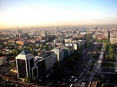
Aerial view

Estadio Santiago Bernabéu
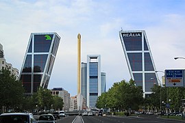
Gate of Europe

CTBA

INE Building

Hospital Universitario La Paz


_48.jpg)

_01.jpg)
_01.jpg)