
Oder
The Oder or Odra (Polish: Odra; German: The Oder; Czech: Odra; Lower Sorabian: Odra) is a major river in Central Europe that Born in the Czech Republic. After flowing (generally in a north-northwest direction) through western Poland and forming for 187 km the present border between Poland and Germany (part of the Oder-German line), Neisse), flows into the Szczecin Lagoon and then, through three branches (Dziwna, Świna and Peenestrom), finally empties into the Pomeranian Bay (Stettiner Haff) in the Baltic Sea.
Administratively, it runs through the Czech regions of Olomouc and Moravian-Silesia, through the Polish voivodeships of Silesia, Opole, Lower Silesia (and its capital Wrocław), Lubusz and Western Pomerania, and borders the German states of Brandenburg and Mecklenburg-Western Pomerania.
The Oder River is 866 km long, although it is the longest course in its basin, reaching 1045 km, corresponds to the Oder-Varta system, since one of its tributaries, the Varta River, is almost equal in length (808 km). Over the past 150 years, channel correction works have reduced the length of the Oder from 1040 km to what it is today 866km. It drains a broad basin of 118,861 km², of which 106,056 km² is in Poland (89%), 7,217 km² in the Czech Republic (6%) and 5,587 km² in Germany (5%). In 1997 the last great flood of the Oder took place, which among other cities badly damaged Wrocław.
Its main tributaries are the aforementioned Varta and the rivers Bóbr (272 km), Neisse ( 252 km), Nysa Kłodzka (182 km), Barycz (139 km), Mała Panew (132 km), Ina (126 km) and Widawa (110km).
Etymology
The Oder is known by various names in different languages, but the most modern ones are very similar: in English and German, Oder; in Czech, Polish and Lower Sorbian, Odra; in Upper Sorbian, Wódra; in Kashubian: Òdra). In medieval Latin: Od(d)era and in Renaissance Latin: Viadrus (a word invented in 1534).
The ancient geographer Claudius Ptolemy located a river Συήβος (Suebos, in Latin: Suevus, from the name of the Suebi tribe at the location of the current Oder), which resembles the modern name of the Świna, the main channel connecting the Szczecin Lagoon with the Baltic Sea. A mouth called Οὐιαδούα (or Οὐιλδούα, due to the graphic similarity of the Α and Λ), and therefore, in Latin Viadua or Vildua, is located by him at a third of the distance between the Suebos and the Vistula, and perhaps corresponding to the modern Wieprz.
In Old Church Slavonic, the name of the river is Vjodr.
History
The river was known by the Romans as the Viadrus or Viadua in classical Latin, which although located in the Germania Magna was already a branch of the amber route that it ran from the Baltic to the Roman Empire (see Roman road). In German language it was, and is called, the Oder, written in the oldest documents as Odera or Oddera in the medieval Latin documents. He is mentioned in the Dagome iudex, which describes the territory of the Duchy of Poland under the rule of Mieszko I of Poland ca. 990, as part of the western border of the duchies.
Before the Slavs settled along its shores, the Oder was already an important trade route and cities in Germany are documented along with many tribes living between the Albis (also known as Elbe), Oder and Vistula. Centuries later, after the Germanic tribes had left, the Bavarian Geographer (ca. 845) refers to the following West Slavic peoples: Sleenzane, Dadosesani, Opoloni, Lupiglaa and Gоlеnsizi in Silesia, and Wolinians and Pyrzycans in West Pomerania. A document from the Bishopric of Prague (1086) mentions Zlasane, Trebovyane, Poborane and Dedositze in Silesia.
In the 13th century the first dams were built to protect farmland.
The Finow Canal, originally built in 1605, connects the Oder and Havel. After the completion in 1914 of the straighter Oder-Havel canal, its economic relevance decreased.
The first actions to improve the waterway were at the initiative of Frederick the Great, who recommended the diversion of the river into a new, straight channel in the swampy stretch of land known as Oderbruch near Küstrin. The work was carried out between 1746-1753: a large tract of marsh was converted to farmland, a considerable diversion was dug, and the main stream was confined to a channel.
At the end of the 19th century three additional modifications were made to make the waterway:
- channeling the main course in Breslavia, and from the confluence of the Glatzer Neisse to the mouth of the channel Klodnitz, a distance of more than 80 km. These engineering works were completed in 1896;
- construction of the Canal Óder-Spree during 1887-1891 to connect the two rivers named;
- deepening and regulation of the mouth and lower course of the current.
By the Treaty of Versailles (1919) navigation on the Oder would be administered by the International Oder Commission. Under articles 363 and 364 of the treaty, Czechoslovakia had the right to lease in Stettin (now Szczecin) its own section on the port, then called Tschechoslowakische Zone im Hafen Stettin. however, after 1945, Czechoslovakia did not recover that legal status, de facto abolished in 1938-1939.
At the 1943 Tehran Conference, the Allies decided that Germany's new eastern border would run along the Oder, but after World War II, the Oder and Lusatian Neisse formed the Oder-Neisse line, which it was designated by the victorious allies at the Potsdam Conference as the new border between Poland and Germany. A significant percentage of the German population east of these two rivers were evacuated by Nazi Germany or fled before the Red Army approached. After the war, the remaining population was forcibly expelled in accordance with the Potsdam Agreement. East Germany confirmed the border with Poland in 1950, although West Germany, after a period of rejection, only accepted that border in 1970. In 1990 the newly reunified Germany and the Republic of Poland signed a treaty recognizing it as their border.
Geography
The Oder is 866 km long: 112 km in the Czech Republic, 742 km in Poland (including the 187 km of the German-Polish border) and is the second longest river in Poland (after the Vistula). It drains a basin of 118,861 km², 106,056 km² of which is in Poland (89%), 7,217 km² in the Czech Republic (6%), and 5,587 km² in Germany (5%). Several canals connect it with the Havel, Spree and Vistula systems and with the Kłodnica. It flows through the Polish voivodeships of Silesia, Opole, Lower Silesia, Lubusz and Western Pomerania and the German states of Brandenburg and Mecklenburg-Western Pomerania.
The main branch empties into the Szczecin Lagoon, near Police. The Szczecin Lagoon is bordered to the north by the islands of Usedom (to the west) and Wolin (east). Between these two islands, there is only a narrow channel (Świna) that connects with the Pomeranian Bay, which is a part of the Baltic.
The largest city in the Oder is Wroclaw, in Lower Silesia.
Course
Course in the Czech Republic
The Oder rises at an altitude of 627 m in the Nízký Jeseník mountain massif, an eastern foothills of the Sudetenland, in the Olomouc district (in the Olomouc region) near and east of the city of Olomouc, in the historical region of Moravia. The small stream heads north for a short stretch, then turns east, entering the Moravian-Silesian region, beginning a short stretch that was used as a border between the historical Moravian and Silesian regions. The Oder turns more and more towards the ESE, passing near the small town of Klokočůvek, the first town of its course with only a little more than a hundred inhabitants. It then reaches Hermánky (182 hab.) and Jakubčovice nad Odrou (673 hab.) to shortly reach Odry (7,350 inhabitants in 2015), the small town that gives it its name.
It continues its progress passing Jeseník nad Odrou (1882 hab.), where the Oder turns sharply to the ENE, in a section with many short meanders and small alluvial lagoons on both sides of the course abandoned in times of flooding. It then reaches the Oder, the small town of Studénka (9792 inhabitants) and soon reaches the important city of Ostrava (297,421 inhabitants in 2013), capital of the Moravian-Silesian region. In Ostrava it receives on the left bank the Opava River (from 119 km) and also on the right, the Ostravice River (40 miles). The Oder then passes through small Bogumin (22,129 inhabitants), almost on the border with Poland, located at the confluence, on the right, with the river Olza (99km). For a short section of less than 10 km the water current will act as a border, a section in which it passes very close to the Polish city of Chalupki (1694 hab. in 2007). Then it goes into Poland through the southern part of the Silesian Voivodeship.
- The Order in the Czech Republic

Pedestrian and cyclist path along the Oder in Odry

The Order near Jakubčovice

The Order near Ostrava
Confluencia del Óder (izqda.) y el Opava (dcha.) en Ostrava

One of the lateral lagoons abandoned by the Order in Rychvald, Karviná district


.jpg)
Course in Poland
Entering Poland, the Oder heads north in a wide, low-lying valley through which Highway 45 also runs and in which it soon reaches the small town of Racibórz (56,397 inhab. in 2012), one of the historical capitals of Upper Silesia. For a short stretch it will be the border between voivodeships, between Silesia and Opole, which it will then enter in the south. It then meets the short Bierawka (55.5 km) on the right, almost opposite the small town of Cisek 1485, inhab. in 2015). It continues its progress passing through Kędzierzyn-Koźle (58,749 inhab. in 2015), a small town located at the confluence with the Kłodnica River (75 km), which approaches the Oder from the left. It then continues through the small towns of Zdzieszowice (13,127 inhab. in 2007) and Krapkowice (17,840 inhab.. in 2007), it is located at the left confluence with the Osobłoga River (65.5 km). It then reaches the important city of Opole (119,465 inhabitants in 2015), the capital of the voivodeship. Leaving Opole, it receives the Prószkowski Potok (40.8 km) on the right bank and then the Mała Panew (132km).
The Oder continues its advance in a northwesterly direction and after receiving Nysa Kłodzka (181.7 km) on the left and Stobrawa (78.1 km), arrives in the city of Brzeg (36,675 inhab. in 2015), to soon enter the Lower Silesian Voivodeship. It immediately reaches the small town of Oława (32,356 inhab. in 2014), where it receives the Oława River (91.7km).
- The Order in Poland before Breslavia
The Order near Racibórz

The port of Kózle, in Kędzierzyn-Koźle. The image shows the mouth of the Gliwice channel.

Confluence of the Oder and the Osobloga
The Order at the Opole entrance
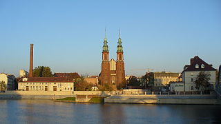
Opole Cathedral in front of the river


Continue through Jelcz-Laskowice (23,200 inhab. in 2015) and reach the important city of Wroclaw (635,759 inhab. in 2015), the capital of the void data and the most populous city in its entire course. It is located at the crossroads of two historical trade routes: the Via Regia and the amber route, and it has been developed on several fluvial islands delimited by old channels and modern canalizations. In the city it receives from the left bank and reaching from the south to the short Ślęza (78.6 km).
- The Order in Breslavia

Breslavia Cathedral on the edge of the river.

The Order in Breslavia.
View of the Rędzińska fluvial island, with the locks that regulate the Oder.

Order your passage through a park in Breslavia.


Past Wroclaw receives Bystrzyca (95 km) on the left and Widawa () on the right 103 km) to then pass through the small towns of Uraz (949 hab.) and Brzeg Dolny (1,663 inhab. in 2008, where the PCC Rokita SA chemical plant is located). It then passes the Cistercian Abbey of Lubiąż, before entering Lubiaz, where it meets Kaczawa (98 km) on the left, before passing Ścinawa (5,767 inhab. in 2015). It continues its advance and the Oder will be the limit of the small ecological reserve of Naroczycki Łęg, a floodplain established in 1999. It continues its slow course, reaching the historic city of Głogów (66,659 hab. in 2011), located at the confluence, on the right, with the Barycz (139 km). It is followed by Bytom Odrzański (4480 inhab. in 2010).
It then enters the Lubusz voivodeship, passing in front of the city of Nowa Sól (40,369 inhabitants in 2011) and just a couple of kilometers north of the major city of Zielona Góra (138,512 inhab. in 2015). As soon as Nowa Sól is left behind, the Óder welcomes Krzycki Rów (74.34 km) and Obrzyca (66 km) just before Cigacice, to momentarily turn east, passing through Krosno Odrzańskie (12,041 hab. in 2012), where it receives, on the left bank, the Bóbr river (272 km). It then continues through the Krzesin Landscape Park, established in 1998 and protecting an area of 85.46 km² on both sides of the Oder. In this protected section it receives the Neisse (252 km) on the left in Ratzdorf (north of Guben, in Brandenburg), a point that starts a section from 187 km where the river will be the international border with Germany.
- The Order between Breslavia and the border

The abbey of Lubiąż

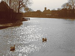
The Oder at your pass by Ścinawa
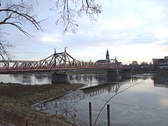
Railway bridge in Głogów
Nowa Town Hall Just the banks of the Order
Bridge in Krosno Odrzańskie
Boca del Neisse Lusacio en el Óder


The river heads clearly in a northerly direction and in this border section it first passes in front of the German city of Eisenhüttenstadt (27,444 inhab. in 2014), 'iron foundry town', an iron and steel town founded in 1950 by the government of the German Democratic Republic as a model of a socialist town and for a time carried the name of Stalinstadt.
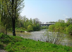
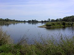
Continuing its advance, it reaches Frankfurt (57,649 inhabitants in 2014) and its Polish twin Słubice (16,872 inhab. in 2015) that until 1945 was part of Frankfurt until the new border was defined. It then continues through the Polish city of Kostrzyn nad Odrą/Küstriner Vorland (18,120 inhabitants in 2014), located at the confluence of its main tributary, the Varta River. (808 km), who tackles him from the right. The entire Polish area of the confluence and lower reaches of the Varta has been declared as the Ujście Warty National Park since 2001. Finally, the Oder enters the West Pomeranian Voivodeship in a northwesterly direction, passing through the small towns of Gozdowice and Osinów Dolny, where the river turns north again.
- The border section of the Order

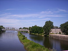
The historical part of the city of Eisenhüttenstadt; the Canal Óder-Spree in the foreground
View of Frankfurt and Słubice

Słubice view, in front of Frankfurt

View of the remains of the ancient fortress of Kuestrin (sixteenth century), destroyed in the Second World War


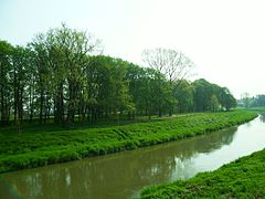
A long section of the Lower Oder valley begins here, in which the river and its banks enjoy joint high protection in both countries. First, on the Polish side, there is the Cedynia Landscape Park (Cedyński Park Krajobrazowy) an area established in 1993 that protects 308.5 km². (This park is managed by the body "Lower Oder Valley Landscape Park Complex" (Zespół Parków Krajobrazowych Doliny Dolnej Odry). The same authority oversees the Lower Oder Valley Landscape Park, the Park Szczecin Landscape Park and the Boca del Varta Landscape Park (in the Landscape Parks there are seven nature reserves.) The Oder River then becomes the western boundary of the German Lower Oder Valley National Park, a long linear park established in 1995 that protects 104.18 km² along almost 60 km from the German shoreline to the border. The Polish shoreline is also protected by another park, the Lower Oder Valley Landscape Park (Park Krajobrazowy Dolina Dolnej Odry), established in 1993 and safeguarding other 71.49 km².
At the beginning of this protected section, it receives, coming from Germany and to the left, the Alte Oder, an old branch of the Oder that comes from the Oderbruch region. Follow Krajnik Dolny, which communicates with the nearby German city of Schwedt. It continues past the small German town of Gartz, where the river divides into two branches: the Western Oder (Polish: Odra Zachodnia) and the Eastern Oder (Odra Wschodnia). The Western Oder branch is a border river to the German town of Mescherin, located opposite the Polish Gryfino, where the Oder re-enters Polish territory.
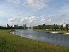
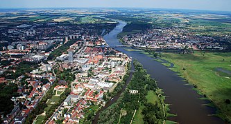
In their final stretch, both branches of the river reach the city of Szczecin (407,047 inhabitants in 2015), the capital of the West Pomeranian Voivodeship, which It has a fluvial port that receives oceanic maritime traffic and that allows the existence of an important naval industry as well as important food, chemical and cement industries. The slope of the last thirty kilometers before Szczecin is only a few centimeters.
- The river Óder in Szczecin
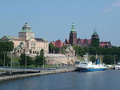
The Order in Szczecin
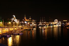
Night view of the Opera
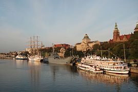
River port


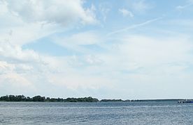
The Oder then widens and overflows into Lake Dąbie (a delta lake about 15 km long and up to 4 km wide that starts inland from the city of Szczecin itself) and then reaches the town of Police (33,625 inhab. in 2014), the last of its course, where it hosts the short Gunica ( 32 km) and the Oder where it begins to widen. In this section it receives the Gowienica (47.9 km) on the right and then flows into the Szczecin lagoon, limited to the north by the Usedom islands (to the west) and Wolin (east) and connecting by a narrow channel between them (Świna) with the Pomeranian Bay, which is a part of the Baltic Sea.
- The Oder after Szczecin

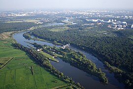
Aerial view of Szczecin and Lake Dąbie
El Óder en Police

The Łarpia, a Distributor of the Order in Police
.jpg)


Cities
In the main course:
- Ostrava – Bohumín – Racibórz – Kędzierzyn-Koźle – Krapkowice – Opole – Brzeg – Oława – Jelcz-Laskowice – Breslavia – Brzeg Dolny – Ścinawa – Szlichtyngowa – Głogów – Bytom Odrzański


In the Szczecin lagoon and its canals:
- in the lagoon: Nowe Warpno – Ueckermünde
- on the Dziwna Channel (between Wolin Island and Continental Poland): Wolin – Kamień Pomorski – Dziwnów
- in the channel of the Świna (between the Wolin and Usedom Islands):
- in the branch Peenestrom (between the island Usedom and mainland Germany): Usedom – Lassan – Wolgast
OZach-panoramic-fragment.jpg)
Tributaries
- Eastern influx (right):
- Ostravice (64 km) – Olza (99 km) – Raude – Bierawka (55.5 km) – Kłodnica (75 km- Czarnka - Mała Panew132 km) – Stobrawa (78.1 km) – Widawa (103 km) – Jezierzyca (33,63 km) – Barycz (139 km) – Krzycki Rów (74.34 km) – Obrzyca (66 km) – Jabłonna – Pliszka – Ołobok – Gryżynka – Varta (808 km) with the Noteć – Myśla – Kurzyca (25 km) – Stubia – Rurzyca – Tywa – Płonia – Ina (126 km) – Gowienica (47.9 km) - Śmieszka
- Western tributaries (left):
- Opava (119 km) – Psina (Cyna) – Cisek – Olszówka – Stradunia (28 km) – Osobłoga (65.5 km) – Proszkowski Potok (40.8 km) – Nysa Kłodzka (181.7 km) – Oława (91.7 km) – Ślęza (78.6 km) – Bystrzyca (95 km) – Średzka Woda (326 km)– Cicha Woda – Kaczawa98 km) – Ślepca – Zimnica – Dębniak – Biała Woda – Czarna Struga – Śląska Ochla – Zimny Potok – Bóbr (Bóbr)272 km) – Olcha – Racza – Neisse Lusacio (252 km) – Finow (13.7 km) – Gunica (32 km).
Hydrometry
The very flat relief of the regions it crosses explains why the Oder sometimes causes catastrophic floods.
The rainfall pattern varies approximately twice a year, with a maximum flow of 783 m³/s in April, when the snow melts, and a minimum flow of 379 m³/s in September).
| Maximum monthly rate of the (in m3/s.) |
 |
Navigation
The Oder is navigable for much of its course, reaching upstream to the city of Koźle, where the river meets the Gliwice Canal. The upstream part of the river was canalized and allows the traffic of larger barges (up to CEMT IV Class) to navigate between the industrial sites of the entire Wroclaw area. Downstream the river flows freely, passing through the cities of Eisenhüttenstadt (where the Oder-Spree canal connects with the Spree in Berlin) and Frankfurt on the Oder. Downstream of Frankfurt, the Warta River allows a navigable connection to Poznań and Bydgoszcz for smaller ships. In Hohensaaten the Oder-Havel canal connects again with the waterways of Berlin.
Near its mouth the Oder reaches the city of Szczecin, an important seaport in the region. The river finally reaches the Baltic Sea through the Szczecin Lagoon, the mouth being in Świnoujście.
Contenido relacionado
Seismogenic faults in the Region of Murcia
Storm bog
Carpet